Walker Park And Nature Trail Photos


You might also consider
More like Walker Park And Nature Trail
Recommended Reviews - Walker Park And Nature Trail
Start your review...

5 years ago
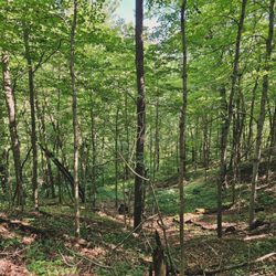
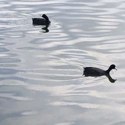
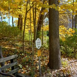
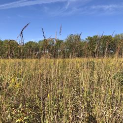
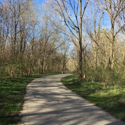
This 11 acre park and nature trail is part of the Zionsville Park system and services the surrounding neighborhoods of Whitestown. The short nature trail has a hard surface but access is over grass. There is natural prairie surrounded by young trees. Maybe a good place to bird watch. Summer overgrowth of the trail left me feeling somewhat unsafe. The play structure is small with basic swings, slides and climbing structure. Not as fancy as the nearby Main Street Park. The local 4-H donated a small pavilion complete with tables and waste cans. The park features a large retention pond with paved sidewalks and benches on two sides. There are supplies for cleaning up after your pooch. Also, there is a nicely maintained field that can be used for soccer or football. There is parking for 16 cars. This is a good neighborhood park. read more


More info about Walker Park And Nature Trail
6310 Albert S White Dr
Whitestown, IN 46075
Directions
Hours
Outdoor Amenities
You might also consider


Walker Park And Nature Trail - parks - Updated July 2026
Best of Whitestown
People found Walker Park And Nature Trail by searching for…
Fun Things to Do in Whitestown, Indiana
Soccer Fields in Whitestown, Indiana
Lakes & Ponds in Whitestown, Indiana
Picnic Areas in Whitestown, Indiana
Walking Trails in Whitestown, Indiana
Hiking Trails in Whitestown, Indiana
Places to Take Pictures in Whitestown, Indiana
Photo Spots in Whitestown, Indiana
Kids Birthday Party Venues in Whitestown, Indiana
Scenic Drive in Whitestown, Indiana
Playgrounds for Kids in Whitestown, Indiana
Kids Birthday Places in Whitestown, Indiana
Scenic Views in Whitestown, Indiana
Running Trails in Whitestown, Indiana
View Points in Whitestown, Indiana
Nature Walks in Whitestown, Indiana
Waterfalls in Whitestown, Indiana
Kids Indoor Play Area in Whitestown, Indiana
Picnic Spots in Whitestown, Indiana
Attractions in Whitestown, Indiana
Beautiful Views in Whitestown, Indiana
Trending Searches in Whitestown, IN
Baby Activities near Walker Park And Nature Trail
Baseball Fields near Walker Park And Nature Trail
Black Owned Nail Salons near Walker Park And Nature Trail
Boardwalk near Walker Park And Nature Trail
Boat Rental near Walker Park And Nature Trail
Cliff Jumping near Walker Park And Nature Trail
Creeks near Walker Park And Nature Trail
Day Trips near Walker Park And Nature Trail
Dog Friendly Beaches near Walker Park And Nature Trail
Dog Swimming near Walker Park And Nature Trail
Fishing Spots near Walker Park And Nature Trail
Free Picnic Areas near Walker Park And Nature Trail
Free Things To Do With Kids near Walker Park And Nature Trail
Jet Ski Rental near Walker Park And Nature Trail
Kayak Rental near Walker Park And Nature Trail
Kids Activities Indoor near Walker Park And Nature Trail
Kids Activities Outdoor near Walker Park And Nature Trail
Lakes near Walker Park And Nature Trail
Off Road Trails near Walker Park And Nature Trail
Outdoor Activities near Walker Park And Nature Trail
Outdoor Basketball Courts near Walker Park And Nature Trail
Paddle Boat Rentals near Walker Park And Nature Trail
Picnic Spots near Walker Park And Nature Trail
Places To Walk Around near Walker Park And Nature Trail
Playgrounds near Walker Park And Nature Trail
Public Pools near Walker Park And Nature Trail
Public Shower near Walker Park And Nature Trail
River Swimming near Walker Park And Nature Trail
Rock Quarry near Walker Park And Nature Trail
Running Trails near Walker Park And Nature Trail
Scenic Night View near Walker Park And Nature Trail
Scenic Overlook near Walker Park And Nature Trail
Secluded Spots near Walker Park And Nature Trail
Soccer Store near Walker Park And Nature Trail
Splash Pad near Walker Park And Nature Trail
Strawberry Picking near Walker Park And Nature Trail
Sunrise View near Walker Park And Nature Trail
Swimming Holes near Walker Park And Nature Trail
Swimming Lakes near Walker Park And Nature Trail
Toddlers Fun Places near Walker Park And Nature Trail
Volleyball Courts near Walker Park And Nature Trail
Watch Sunset near Walker Park And Nature Trail
Water Parks near Walker Park And Nature Trail
Browse Nearby
BEST of Whitestown, Indiana Things to Do near Walker Park And Nature Trail
BEST of Whitestown, Indiana Coffee near Walker Park And Nature Trail
BEST of Whitestown, Indiana Restaurants near Walker Park And Nature Trail
BEST of Whitestown, Indiana Playgrounds near Walker Park And Nature Trail
BEST of Whitestown, Indiana Hiking near Walker Park And Nature Trail
BEST of Whitestown, Indiana Breakfast near Walker Park And Nature Trail
Browse Brands
Related Searches in Whitestown, IN
Affordable Kayak Rental Services in Whitestown, Indiana
Best Dog Hiking Trails Around Whitestown, Indiana
Best Fishing Locations and Guides in Whitestown, Indiana
Best Kids Birthday Places to Celebrate in Whitestown, Indiana
Best Kids Playgrounds to Visit in Whitestown, Indiana
Best Off Leash Dog Parks in Whitestown, Indiana
Best Parks for Parties and Events in Whitestown, Indiana
Best Places for Horseback Riding in Whitestown, Indiana
Best Sightseeing Experiences Available in Whitestown, Indiana
Best Water Parks for Kids in Whitestown, Indiana
Check Out Great Playgrounds in Whitestown, Indiana
Check Out Off Road Trails in Whitestown, Indiana
Discover Baseball Fields Around Whitestown, Indiana
Discover Dog Friendly Trails to Explore in Whitestown, Indiana
Discover Fun Kid Activities to Enjoy in Whitestown, Indiana
Discover Fun Toddler Parks in Whitestown, Indiana for Your Little One
Discover Kids Indoor Play Area Venues in Whitestown, Indiana
Discover Lakes & Ponds to Explore in Whitestown, Indiana
Discover Popular Bike Trails in Whitestown, Indiana
Discover Popular Photo Spots in Whitestown, Indiana
Discover Scenic Mountain Bike Trails Near Whitestown, Indiana
Discover Soccer Fields in Whitestown, Indiana Near You
Discover Top Nature Parks to Visit in Whitestown, Indiana
Discover Top State Parks to Visit in Whitestown, Indiana
Discover Walking Parks in Whitestown, Indiana Near You
Discover a Hiking Trail in Whitestown, Indiana
Discover the Best Beaches in Whitestown, Indiana
Discover the Best Fishing Lake in Whitestown, Indiana
Discover the Best Kids Park Spots in Whitestown, Indiana
Discover the Best Night Hike Trails in Whitestown, Indiana
Dog-Friendly Hikes With Dogs in Whitestown, Indiana
Enjoy Camping Adventures Around Whitestown, Indiana
Enjoy Kayaking Adventures in Whitestown, Indiana
Enjoy Off Leash Dog Hikes in Whitestown, Indiana
Enjoy Tent Camping Spots Around Whitestown, Indiana
Enjoy a Beautiful Waterfall Hike in Whitestown, Indiana
Enjoy the Best Mini Golf Courses in Whitestown, Indiana
Enjoy the Best Picnic Spots and Ideas in Whitestown, Indiana
Enjoy the Best Walking Trails in Whitestown, Indiana
Explore Beautiful Parks and Green Spaces in Whitestown, Indiana
Explore Easy Hikes Perfect for All in Whitestown, Indiana
Explore Free Kids Activities Near Whitestown, Indiana
Explore Free Picnic Areas Around Whitestown, Indiana
Explore Fun Activities to Do in Whitestown, Indiana
Explore Outdoor Basketball Courts for All Skill Levels in Whitestown, Indiana
Explore Parks With Pull Up Bars in Whitestown, Indiana
Explore Picnic Parks Near Whitestown, Indiana
Explore Popular Campgrounds Near Whitestown, Indiana