Whitehorse Trail Photos


You might also consider
More like Whitehorse Trail
Recommended Reviews - Whitehorse Trail
Start your review...

1 month ago
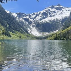
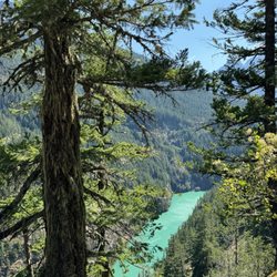
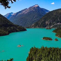
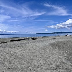
Spanning over 27 mi between Arlington and Darrington, this old railroad track was converted to a scenic trail in the 90s. It parallels the North Fork of the Stillaguamish River. There are picturesque views of forests, farmland, streams, rivers, waterfalls, and wildlife. There are many access to the tral along its route. Check out the Washington Trail Association or Snohomish County Parks and Facilities websites for more info. read more


More info about Whitehorse Trail


Whitehorse Trail - hiking - Updated June 2026
Best of Darrington
People found Whitehorse Trail by searching for…
Fun Things to Do in Darrington, Washington
Parks in Darrington, Washington
Hiking Trails With Waterfalls in Darrington, Washington
Camping in Darrington, Washington
Dog Friendly in Darrington, Washington
Sunset View in Darrington, Washington
Stairs Workout in Darrington, Washington
Running Trails in Darrington, Washington
Trending Searches in Darrington, WA
Boat Rental near Whitehorse Trail
Cherry Picking near Whitehorse Trail
Cliff Jumping near Whitehorse Trail
Day Trips near Whitehorse Trail
Dog Swimming near Whitehorse Trail
Fishing Spots near Whitehorse Trail
Kayak Rental near Whitehorse Trail
Off Road Trails near Whitehorse Trail
Pick Your Own Farms near Whitehorse Trail
Public Pools near Whitehorse Trail
Public Shower near Whitehorse Trail
River Swimming near Whitehorse Trail
Rock Quarry near Whitehorse Trail
Scenic Drive near Whitehorse Trail
Scenic Night View near Whitehorse Trail
Secluded Spots near Whitehorse Trail
Splash Pad near Whitehorse Trail
Strawberry Picking near Whitehorse Trail
Swimming Holes near Whitehorse Trail
Browse Articles
Browse Nearby
BEST of Darrington, Washington Things to Do near Whitehorse Trail
BEST of Darrington, Washington Parks near Whitehorse Trail
BEST of Darrington, Washington Restaurants near Whitehorse Trail
BEST of Darrington, Washington Coffee near Whitehorse Trail
BEST of Darrington, Washington Campgrounds near Whitehorse Trail
BEST of Darrington, Washington Photo Spots near Whitehorse Trail
BEST of Darrington, Washington Taxis near Whitehorse Trail
BEST of Darrington, Washington Breakfast near Whitehorse Trail
Browse Brands
Related Searches in Darrington, WA
Affordable Paddle Board Rental in Darrington, Washington
Best Fishing Locations and Guides in Darrington, Washington
Best Places for Horseback Riding in Darrington, Washington
Check Out Off Road Trails in Darrington, Washington
Discover Dog Friendly Beaches Near Darrington, Washington
Discover Dog Friendly Trails to Explore in Darrington, Washington
Discover Popular Photo Spots in Darrington, Washington
Discover Scenic Mountain Bike Trails Near Darrington, Washington
Discover Top Boat Tours in Darrington, Washington for All Ages
Discover a Hiking Trail in Darrington, Washington
Discover the Best Night Hike Trails in Darrington, Washington
Dog-Friendly Hikes With Dogs in Darrington, Washington
Enjoy Camping Adventures Around Darrington, Washington
Enjoy a Beautiful Waterfall Hike in Darrington, Washington
Enjoy the Best Tubing Experiences in Darrington, Washington
Enjoy the Best Walking Trails in Darrington, Washington
Exciting Cliff Jumping Spots in Darrington, Washington
Experience Stunning Sunset Views in Darrington, Washington
Explore Beautiful Parks and Green Spaces in Darrington, Washington
Explore Bike Rentals Throughout Darrington, Washington
Explore Easy Hikes Perfect for All in Darrington, Washington
Explore Family-Friendly Zoos and Wildlife in Darrington, Washington
Explore Popular Campgrounds Near Darrington, Washington
Explore Popular RV Parks Around Darrington, Washington
Explore Scenic Lakes to Visit in Darrington, Washington
Explore Secret Spots Worth Visiting in Darrington, Washington
Explore Top Dog Parks in Darrington, Washington Near You
Explore Top Water Parks in Darrington, Washington Today
Explore the Best Swimming Holes Around Darrington, Washington
Find Fun Things to Do With Kids in Darrington, Washington
Find Top Skate Parks in Darrington, Washington for All Skill Levels
Find Top-Rated Disc Golf in Darrington, Washington
Find the Best Playgrounds to Visit in Darrington, Washington
Find the Best Scenic View Locations in Darrington, Washington
Find the Best Swimming Pools in Darrington, Washington Today
Hiking Trails With Waterfalls in Darrington, Washington
Must-See Tourist Attractions Around Darrington, Washington
Off Leash Dog Hiking Trails in Darrington, Washington
Perfect Spots to Watch Sunset in Darrington, Washington
Popular Fishing Spots to Explore in Darrington, Washington
Popular Kids Activities in Darrington, Washington
Popular Places to Take Pictures in Darrington, Washington
Popular Things to Do in Darrington, Washington
Safe River Swimming Areas in Darrington, Washington
See Top Fireworks Events in Darrington, Washington
Top Fishing Charter Experiences in Darrington, Washington
Top Playgrounds for Kids to Enjoy in Darrington, Washington
Top Running Trails to Explore in Darrington, Washington
People who viewed Whitehorse Trail also viewed
Goat Lake Trail
7 reviews
Mother Nature’s Window Trailhead
1 review
Northern State Recreation Area
22 reviews
Boulder River Trail
11 reviews
Centennial Trail
14 reviews
Howard Miller Steelhead Park
22 reviews
Nakashima Barn - Centennial Trail
1 review
Pilchuck Park
1 review
Worlds Smallest Park
1 review
Silo Park
3 reviews