Cancel

    Open app

    Search

    Wilbur's Watch

    5.0 (2 reviews)

    Wilbur's Watch Photos

    You might also consider

    Recommended Reviews - Wilbur's Watch

    Your trust is our priority, so businesses can't pay to alter or remove their reviews. Learn more about reviews.
    Yelp app icon
    Browse more easily on the app
    Review Feed Illustration

    18 years ago

    Helpful 6
    Thanks 0
    Love this 5
    Oh no 0
    Photo of Jeff P.
    288
    11
    0

    9 years ago

    Helpful 1
    Thanks 0
    Love this 0
    Oh no 0

    You might also consider
    Verify this business for free

    People searched for Hiking 1,143 times last month within 15 miles of this business.

    Verify this business

    Castle Rock State Park

    Castle Rock State Park

    4.6
    (430 reviews)
    23.0 km

    Have long eyed the Castle Rock State Park and glad we finally went! The park charges a nominal…read moreparking fee ($10 at time of writing); the parking fee is waived if you have one of the supported passes. Check their site for more info: https://www.parks.ca.gov/?page_id=538# We really enjoyed our hike here. The space is beautiful, and the trails are well-maintained. The trailhead had plenty restrooms as well. We made it up to Goat Rock Lookout, back down, then detour to the waterfall. It took ~1.5 hours in total, which was perfect for a end-of-day hike before the park closes at sunset. The view up at Goat Rock Lookout was breathtaking!

    If you're looking for another place that has breathtaking views surrounding the whole Santa Cruz…read moreMountains (but don't want to go all the way to Portola Valley), Castle Rock State Park is the place for you. This place is usually my go to when the weather is just perfect and you want good views of the mountains viewing the Monterey Bay and the Santa Clara Valley. In addition, the park is even open during the cold winter season, where it occasionally will snow (because of how high the elevation is, the main base is situated at about 3,200 feet above sea level). This place has been my go-to park for hiking for a while, because of its terrain. At the same time, it's also been because of how much snow they get when cold fronts come into effect. They are also open year-round, so definitely swing by this state park when you do get the chance to! It's a decision you'll never regret.

    Photos
    Castle Rock State Park
    Castle Rock State Park
    Castle Rock State Park

    See all

    Whitehouse Ridge Trail

    Whitehouse Ridge Trail

    5.0
    (1 review)
    0.0 km

    I'm sure if you read my reviews you'll see that I sound like a broken record when I talk about all…read morethe nature and hiking around the Bay Area. Yet, I'm still amazed when I discover a new area like the redwood-lined woods along the Whitehouse Ridge Trail. This trail is hidden away off the Pacific Coast Highway between Santa Cruz and Half Moon Bay, a place I find myself weekly. However, I only recently discovered this trailhead down Whitehouse Canyon Road. You'll have to be vigilant to notice the street because it's unmarked off of the PCH 1, but about 2.3 miles up a very uneven dirt road you'll come to a little parking area right before a private residence area. The Whitehouse Ridge trail is 1.2 miles but moderately strenuous in my opinion (maybe a little less depending on your fitness level) but is worth it for the totally amazing views of Franklin Point, Pigeon Point lighthouse, and Año Nuevo Point. You can choose the lower vista for a short hike or go up to the higher vista point for better views and further exploration amongst the redwoods. This area skirts Big Basin State Park and continues onto Chalk Mountain to eventually connect with the West Ridge Trail. To do the whole thing from Whitehouse Ridge to West Ridge would take all day so do some exploring before you attempt it all because it would not be a walk in the park (heh). This is one of my favorite hikes in Northern California. If you're looking for a moderate hike in a shaded area try this. Here's a link to a Google maps with markers to aid you: https://goo.gl/zx0e2b

    Photos
    Whitehouse Ridge Trail
    Whitehouse Ridge Trail
    Whitehouse Ridge Trail

    See all

    Skyline to the Sea Trail

    Skyline to the Sea Trail

    4.6
    (11 reviews)
    20.0 km

    I've only hiked about 16 miles of this trail, but my oh my is it absolutely breathtaking! This is…read moretruly a hiker's and backpacker's dream trail. I've hiked about 8 miles of this trail through Castle Rock State Park and another 8 miles through Big Basin Redwoods State Park. I hiked this trail with a friend last year up to Berry Creek Falls and it was absolutely stunning! The actual trail itself is almost 30 miles long and stretches from the Santa Cruz Mountains all the way to Big Basin Redwoods State Park. The trail begins at the Saratoga Gap which is a ridge within the Santa Cruz Mountains. It makes its' way up the coast past the Pacific Ocean, then through the beautiful mountains of Castle Rock State Park, and finally through the amazing Redwoods within Big Basin Redwoods State Park. This trail has such an amazing variation of different terrains. From your typical coastal ridge paths, to hilly and mountainous inclines, to flat and paved excursions through the Redwoods; this trail seems to simply have it all. I'd have to say that my favorite section of this trail was definitely being able to hike through the Redwoods. Big Basin is California's oldest park and you'll get to see the most amazing old growth Redwood trees. I've always been fascinated by Redwoods, so exploring them while on this trail was so much fun. Aside from the Redwoods, the stretch of this trail through Big Basin is extremely green and filled with a plethora of different plant species and vibrant flowers. And of course, there's Berry Creek Falls which is pretty much the icing on the cake. This waterfall is beautiful and worth the extra miles to get there. I can't forget to mention the incredible rock formations that you'll see while hiking the section that goes through Castle Rock State Park. These views are equally mesmerizing. It's definitely a great workout as much of the trail ascends and descends through the mountains. Lots of water is must and I would recommend bug spray (at least for the portion that runs through Big Basin). I would love to hike the rest of this trail at some point and hopefully make it down to the beach one day. Either way, any hike along this trail will be enjoyable whether it's 5 miles or 30. Would highly recommend this hike if you're planning on visiting Big Basin Redwoods, Castle Rock, Sanborn County Park, or Saratoga Gap Open Space Preserve.

    What a fantastic trail! 30+ miles over 3 days starting at Castle Rock campground to Waddell Beach…read more(stopping at Waterman Campground and Jay Campground at the Big Basin HQ). Almost all shaded by the trees (lots of redwoods!) and fantastic scenery the entire time, will well marked trails. You pretty much can't get lost at all. If you do, you deserve to get lost! Also all these campsites have piped drinking water and pit toilets so you probably don't need to bring your water pump. You'll need to make these reservations quite early too since they're pretty limited. State park # is (831) 338-8861 to make the reservations. NIGHT 0: Castle Rock Campground. We ended up not actually staying here because we thought (and there wasn't anything that indicated otherwise) that the campground was right at the trailhead. Instead it's 2.7 miles in. Thus as we had prepared for car camping the first night and were meeting others the next morning at the trailhead, we decided to find another campground elsewhere that was next to the road. Parking at Castle Rock trailhead gets crazy packed on the weekends so come early! The parking lot also closes at sunset so you'll need to make sure your car is in before then. DAY 1: This will be the most "complicated" path since you have to take a couple different trails. As you hike towards Castle Rock (assuming you didn't stay there the night before), you'll see a bunch of day climbers and boulderers. Gorgeous views above the tree skyline along the way. http://www.yelp.com/biz_photos/skyline-to-the-sea-trail-davenport?select=mjXU08P2ueRqY-WvlfHxSw#yvfjWy3mdAw7PSTrD67dWw After you past Castle Rock, take the Travertine Springs Trail for ~2 miles which will connect to the Saratoga toll road trail for another mile until you hit an uphill dirt road on your right. It's 0.4 miles going up a couple hundred feet so not too bad. This will take you to the Skyline to the Sea trail (finally!) in which you'll take this for another ~2.6 miles to Waterman camp. You'll hug Highway 9 pretty closely so you'll see a couple abandoned cars that fell off the road. This one more recent. http://www.yelp.com/biz_photos/skyline-to-the-sea-trail-davenport?select=mjXU08P2ueRqY-WvlfHxSw#QekFu-9mgaN6xt7NUH5KsA. And this one from a while ago! http://www.yelp.com/biz_photos/skyline-to-the-sea-trail-davenport?select=mjXU08P2ueRqY-WvlfHxSw#UnpOYfPqPlJ-impxBrz65A NIGHT 1: Waterman Gap Campground Your instinct may be to tucker down at the sites right around the pit toilet. My advice is to walk a little further towards the back to sites 5 and 6. It's a a bit extra of a hike but totally worth it since you get your privacy. Campsite isn't too far from Highway 9 too so you may hear some speedracers zooming by at night like we did. This is also the first (and only) area where you do get cell phone reception. DAY 2: You pretty much stay on Skyline to the Sea trail the entire way from here now. Your goal now is to get to the Jay Campground at Big Bason HQ. You still hug the road sometimes and even cross it a couple times. Again gorgeous views along here. http://www.yelp.com/biz_photos/skyline-to-the-sea-trail-davenport?select=mjXU08P2ueRqY-WvlfHxSw#WIfT7_JSDYc7zXVP0uHMWA NIGHT 2: Jay Campground You're at the park HQ so good time to stock up on stuff or get a bit of real food if you're tired of your freeze dried! THEY DO HAVE BEER THOUGH. And showers too (1 quarter = 2 min), The camp shop does not carry propane for Jet Boilers in case you run out like we did. However you can ask them to use their hot water though to heat up your freeze dried foods. DAY 3: You're almost there! A slight change in scenery here. No more hugging highways and more bridge crossing and waterfalls. Oh and way more banana slugs. http://www.yelp.com/biz_photos/skyline-to-the-sea-trail-davenport?select=mjXU08P2ueRqY-WvlfHxSw#mjXU08P2ueRqY-WvlfHxSw I swear, the last ~3 miles felt like FOREVER. The trail opens wider and the trees start thinning in front of you which makes you constantly feel like you're almost there. Then you immediately smell the salty ocean breeze and which iswhen you know you're at the end!
    Photos
    Skyline to the Sea Trail
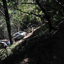
    Another abandoned car that fell off Hwy 9 into the trail!
    Another abandoned car that fell off Hwy 9 into the trail!
    Skyline to the Sea Trail

    See all

    Purisima Creek Trail

    Purisima Creek Trail

    4.6
    (61 reviews)
    20.3 km

    We drove to the Purisima Creek Road Parking Area, arriving at 9:50 on Friday as the 5th car in the…read more7 spaces lot. Toilet at trailhead; out of TP by afternoon so BYOpaper just in case. Walking next to the creek was easy and tranquil. Looped up Craig Britton Trail for vista views. Had a trail lunch at a u turn. Later at Harkins Ridge Trail, we were treated to see and hear a beautiful bird pecking on a tree trunk. I think the best part of hiking this trail is the lack of people; we had the forest to ourselves. We finished this 7.4 miles loop in 4 hrs, including a lunch stop.

    Did the Whittemore Gulch and Harkins Loop trail a few weeks back and boy oh boy, the the hike was…read moreamazing. Route was strenuous, as advertised but awesome. The hike was about 80% shaded in some of the most gorgeous redwood forests, with crisp woodsy air, and lots of flora and wildlife. Wooded trails were nice and cool, which afforded a welcome respite from the warmer ambient temperature (non forested). Saw a lot of banana slugs, some dear, and a bunch of flowers of different types-some endemic and sadly some invasive to the bay. The hike offered views of the bay (at the expense of no shade) on top of the ridge, which was neat. Elevation gain of the hike was approximately 1500 feet, which was gradual in some parts but more steep on others. Didn't use a hiking pole, but wish I did because my legs felt like jello afterwards! The hike which was advertised as around 7 miles took my friend and me about 3h45m (advertised recommended time as 4h-4h30m) with a bunch of rest breaks. Definitely would be back to explore the other trails and get a good dose of trees and nature.

    Photos
    Purisima Creek Trail
    Purisima Creek Trail
    Purisima Creek Trail

    See all

    Wilbur's Watch - hiking - Updated August 2026

    Loading...
    Loading...
    Loading...