Abigail Adams State Park Photos


You might also consider
More like Abigail Adams State Park
Recommended Reviews - Abigail Adams State Park
Start your review...

7 years ago
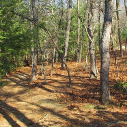
This park is THE #1 place to play Community Day in Pokemon Go for most players. There's been multiple articles written about it for a years now. The spawn rates for Pokemon are very high, lots of PokeStops, and some PokeGymes. You could also play other AR games like Ingress & Harry Potter Wizards Unite. If you are a photographer this is a also a great spot. There's a path, and several benches. read more


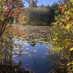
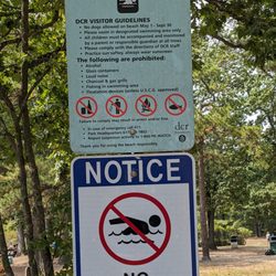
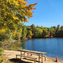
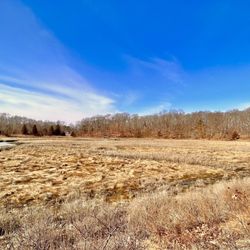
I have passed by this place at least a few dozen times. Each time I only see a small spot for a few cars and didn't bother to go in any further. Today my boyfriend and I decided to go for a walk and since the last time we passed by there were several Pokéstops and lures going on we thought we could make this a nice fun Friday evening adventure as we have been talking about coming here for some time now but just never made it. The turn into the bigger lot is pretty sharp on the right as you're headed north on Bridge St. There are also a few spots right up front but it's usually occupied, and so was today. We went all the way in and had to come back out because there was no place to park, except a couple of handicap spots. There is also a Yacht club on the far right of the park. The park isn't very big but it's very nicely done. The drought however, along with people walking on the grass, has really damaged the greens turning them tan and dried out. We parked in the side and sat and watched the sunset as I played PokémonGo until a spot opened up. We grabbed it and headed to the park for the walk and the play. It was really beautiful seeing so many people out. We walked alongside the bank of the water and it was low tide so saw the bottoms of the land. The houses across the way was nice too. There were a couple of trails you can walk over to just off the "Kibby's Property" sign but since ITT was getting dark we decided not to go in. And at nighfall, a truck came about starting rounding up the people and lead them out of the park because although it's open year round, it closes at dusk and it was beyond dusk at that point. Best park about this small park is that it had at least about 13 Pokéstops and the lures were going on all of them. Had a great time here and will definitely come back again soon! read more

More info about Abigail Adams State Park
You might also consider


Abigail Adams State Park - hiking - Updated June 2026
Best of Weymouth
People found Abigail Adams State Park by searching for…
Beaches in Weymouth, Massachusetts
Sunset View in Weymouth, Massachusetts
Playgrounds in Weymouth, Massachusetts
Walking Trails in Weymouth, Massachusetts
Picnic Areas in Weymouth, Massachusetts
Watch Sunset in Weymouth, Massachusetts
Scenic Night View in Weymouth, Massachusetts
Fishing Spots in Weymouth, Massachusetts
Public Shower in Weymouth, Massachusetts
Swimming Lakes in Weymouth, Massachusetts
Harry Potter in Weymouth, Massachusetts
River Swimming in Weymouth, Massachusetts
Lakes & Ponds in Weymouth, Massachusetts
Parks for Kids in Weymouth, Massachusetts
Places to Take Pictures in Weymouth, Massachusetts
Parks BBQ Grills in Weymouth, Massachusetts
Kids Friendly Beaches in Weymouth, Massachusetts
Bike Trails in Weymouth, Massachusetts
Playgrounds for Kids in Weymouth, Massachusetts
Secluded Beach in Weymouth, Massachusetts
Free Swimming Pool in Weymouth, Massachusetts
Picnic Spots in Weymouth, Massachusetts
Trending Searches in Weymouth, MA
Baseball Fields near Abigail Adams State Park
Beaches near Abigail Adams State Park
Bird Sanctuary near Abigail Adams State Park
Black Owned Nail Salons near Abigail Adams State Park
Boardwalk near Abigail Adams State Park
Boat Rental near Abigail Adams State Park
Cliff Jumping near Abigail Adams State Park
Day Trips near Abigail Adams State Park
Dog Friendly Beaches near Abigail Adams State Park
Dog Friendly Trails near Abigail Adams State Park
Fishing Spots near Abigail Adams State Park
Free Kids Activities near Abigail Adams State Park
Jet Ski Rental near Abigail Adams State Park
Kids Activities Outdoor near Abigail Adams State Park
Lakes near Abigail Adams State Park
Lakes & Ponds near Abigail Adams State Park
Off Road Trails near Abigail Adams State Park
Outdoor Activities near Abigail Adams State Park
Outdoor Basketball Courts near Abigail Adams State Park
Parks With Pull Up Bars near Abigail Adams State Park
Pick Your Own Farms near Abigail Adams State Park
Places To Walk Around near Abigail Adams State Park
Public Beaches near Abigail Adams State Park
Public Shower near Abigail Adams State Park
River Swimming near Abigail Adams State Park
Rock Quarry near Abigail Adams State Park
Scenic Drive near Abigail Adams State Park
Secluded Spots near Abigail Adams State Park
Soccer Store near Abigail Adams State Park
Splash Pad near Abigail Adams State Park
Strawberry Picking near Abigail Adams State Park
Sunrise View near Abigail Adams State Park
Swimming Holes near Abigail Adams State Park
Swimming Lakes near Abigail Adams State Park
Swimming Pools near Abigail Adams State Park
View Fireworks near Abigail Adams State Park
Watch Sunset near Abigail Adams State Park
Water Parks near Abigail Adams State Park
Browse Nearby
BEST of Weymouth, Massachusetts Things to Do near Abigail Adams State Park
BEST of Weymouth, Massachusetts Restaurants near Abigail Adams State Park
BEST of Weymouth, Massachusetts Coffee near Abigail Adams State Park
BEST of Weymouth, Massachusetts Parks near Abigail Adams State Park
BEST of Weymouth, Massachusetts Beaches near Abigail Adams State Park
BEST of Weymouth, Massachusetts Breakfast near Abigail Adams State Park
Browse Brands
Related Searches in Weymouth, MA
Affordable Kayak Rental Services in Weymouth, Massachusetts
Best Fishing Locations and Guides in Weymouth, Massachusetts
Best Nature Trails for Hiking in Weymouth, Massachusetts
Best Off Leash Dog Parks in Weymouth, Massachusetts
Best Parks for Parties and Events in Weymouth, Massachusetts
Best Places for Horseback Riding in Weymouth, Massachusetts
Best Water Parks for Kids in Weymouth, Massachusetts
Check Out Great Playgrounds in Weymouth, Massachusetts
Check Out Off Road Trails in Weymouth, Massachusetts
Discover Baseball Fields Around Weymouth, Massachusetts
Discover Beautiful Garden Spots in Weymouth, Massachusetts
Discover Dog Friendly Trails to Explore in Weymouth, Massachusetts
Discover Free Parking Options in Weymouth, Massachusetts
Discover Lakes & Ponds to Explore in Weymouth, Massachusetts
Discover Popular Photo Spots in Weymouth, Massachusetts
Discover Public Beaches to Visit in Weymouth, Massachusetts
Discover Scenic Mountain Bike Trails Near Weymouth, Massachusetts
Discover Soccer Fields in Weymouth, Massachusetts Near You
Discover Top State Parks to Visit in Weymouth, Massachusetts
Discover a Hiking Trail in Weymouth, Massachusetts
Discover the Best Beaches in Weymouth, Massachusetts
Discover the Best Night Hike Trails in Weymouth, Massachusetts
Enjoy Camping Adventures Around Weymouth, Massachusetts
Enjoy Exciting Mountain Biking Adventures in Weymouth, Massachusetts
Enjoy Kayaking Adventures in Weymouth, Massachusetts
Enjoy a Beautiful Waterfall Hike in Weymouth, Massachusetts
Enjoy the Best Walking Path in Weymouth, Massachusetts
Enjoy the Best Walking Trails in Weymouth, Massachusetts
Exciting Cliff Jumping Spots in Weymouth, Massachusetts
Explore Beautiful Parks and Green Spaces in Weymouth, Massachusetts
Explore Easy Hikes Perfect for All in Weymouth, Massachusetts
Explore Family-Friendly Zoos and Wildlife in Weymouth, Massachusetts
Explore Free Picnic Areas Around Weymouth, Massachusetts
Explore Fun Activities to Do in Weymouth, Massachusetts
Explore Parks With Pull Up Bars in Weymouth, Massachusetts
Explore Popular Campgrounds Near Weymouth, Massachusetts
Explore Popular Picnic Areas Around Weymouth, Massachusetts
Explore Popular RV Parks Around Weymouth, Massachusetts
Explore Popular Scenic Overlook Points in Weymouth, Massachusetts
Explore Popular Scenic Views Near Weymouth, Massachusetts
Explore Scenic Lakes to Visit in Weymouth, Massachusetts
Explore Secret Spots Worth Visiting in Weymouth, Massachusetts
Explore Top Dog Parks in Weymouth, Massachusetts Near You
Explore Top Water Parks in Weymouth, Massachusetts Today
Explore the Best Beach Spots in Weymouth, Massachusetts
Explore the Best Boating Spots in Weymouth, Massachusetts
Explore the Best Swimming Holes Around Weymouth, Massachusetts
Explore the Best Trail Options in Weymouth, Massachusetts
Browse Articles
People who viewed Abigail Adams State Park also viewed
Pope John Paul II Park
20 reviews
Webb Memorial State Park
19 reviews
Faxon Park
10 reviews
Whitney and Thayer Woods
6 reviews
Wompatuck State Park
50 reviews
Stony Brook Reservation
12 reviews
Hyde Park
Quincy Quarries Reservation
36 reviews
Great Hill Park
1 review
Jamaica Pond
115 reviews
Jamaica Plain
Merrymount Park
7 reviews