Blue Mountain Recreation Area Photos


More like Blue Mountain Recreation Area
Recommended Reviews - Blue Mountain Recreation Area
Start your review...

13 years ago
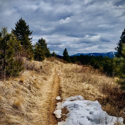
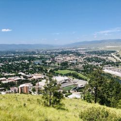
endless trails for puppy tails... Love Blue Mountain...I take my dogs there on a regular basis to run, hike, and retrieve their favorite ball. We love going here because there is a new, undiscovered (by us) trail around every bend. You can go on a short, quick hike or make it an all-day affair. Awesome place just minutes from downtown Missoula. read more


More info about Blue Mountain Recreation Area
5500 Blue Mountain Rd
Missoula, MT 59801
Directions
Visit Website
http://www.fs.usda.gov/
Hours
Outdoor Amenities


Blue Mountain Recreation Area - hiking - Updated June 2026
Best of Missoula
People found Blue Mountain Recreation Area by searching for…
Places to Take Pictures in Missoula, Montana
Fun Things to Do at Night in Missoula, Montana
Hiking Trails in Missoula, Montana
Waterfall Hike in Missoula, Montana
Picnic Areas in Missoula, Montana
Things to Do in Missoula, Montana
Scenic Views in Missoula, Montana
Off Road Trails in Missoula, Montana
Beautiful Views in Missoula, Montana
Attractions in Missoula, Montana
Tent Camping in Missoula, Montana
Easy Hikes in Missoula, Montana
Things to Do on a Rainy Day in Missoula, Montana
Hiking Trails Kid Friendly in Missoula, Montana
Scenic Overlook in Missoula, Montana
Walking Trails in Missoula, Montana
Running Trails in Missoula, Montana
Trending Searches in Missoula, MT
Boat Rental near Blue Mountain Recreation Area
Day Trips near Blue Mountain Recreation Area
Fishing Spots near Blue Mountain Recreation Area
Lakes near Blue Mountain Recreation Area
Parks near Blue Mountain Recreation Area
Picnic Areas near Blue Mountain Recreation Area
Pool Supplies near Blue Mountain Recreation Area
River Tubing near Blue Mountain Recreation Area
Scenic Drive near Blue Mountain Recreation Area
Browse Articles
Browse Nearby
BEST of Missoula, Montana Restaurants near Blue Mountain Recreation Area
BEST of Missoula, Montana Coffee near Blue Mountain Recreation Area
BEST of Missoula, Montana Things to Do near Blue Mountain Recreation Area
BEST of Missoula, Montana Breakfast near Blue Mountain Recreation Area
BEST of Missoula, Montana Shopping near Blue Mountain Recreation Area
BEST of Missoula, Montana Thrift Stores near Blue Mountain Recreation Area
Browse Brands
Related Searches in Missoula, MT
Best Fishing Locations and Guides in Missoula, Montana
Best Fun Things to Do in Missoula, Montana
Best Places for Horseback Riding in Missoula, Montana
Best Places for Stunning Views in Missoula, Montana
Best Waterfalls and Swimming Holes in Missoula, Montana
Check Out Off Road Trails in Missoula, Montana
Discover Kid Friendly Hiking Trails in Missoula, Montana
Discover Popular Bike Trails in Missoula, Montana
Discover a Hiking Trail in Missoula, Montana
Enjoy Camping Adventures Around Missoula, Montana
Enjoy Exciting Mountain Biking Adventures in Missoula, Montana
Enjoy Kayaking Adventures in Missoula, Montana
Enjoy River Tubing Adventures in Missoula, Montana
Enjoy Tent Camping Spots Around Missoula, Montana
Enjoy the Best Picnic Spots and Ideas in Missoula, Montana
Enjoy the Best Tubing Experiences in Missoula, Montana
Enjoy the Best Walking Trails in Missoula, Montana
Explore Beautiful Parks and Green Spaces in Missoula, Montana
Explore Easy Hikes Perfect for All in Missoula, Montana
Explore Free Things to Do Around Missoula, Montana
Explore Fun Activities to Do in Missoula, Montana
Explore Nature Spots Around Missoula, Montana
Explore Popular Campgrounds Near Missoula, Montana
Explore Popular RV Parks Around Missoula, Montana
Explore Popular Scenic Overlook Points in Missoula, Montana
Explore Scenic Lakes to Visit in Missoula, Montana
Explore the Best Boating Spots in Missoula, Montana
Explore the Best Trail Options in Missoula, Montana
Explore the Scenic River in Missoula, Montana
Family Friendly Hiking With Kids in Missoula, Montana
Find Cozy Camping Cabins in Missoula, Montana
Find Fun Things to Do With Kids in Missoula, Montana
Find the Best Parks for Picnics in Missoula, Montana
Find the Best Playgrounds to Visit in Missoula, Montana
Find the Best Scenic View Locations in Missoula, Montana
Hiking Trails With Waterfalls in Missoula, Montana
Must-See Tourist Attractions Around Missoula, Montana
Plan a Scenic Drive Route Near Missoula, Montana
Popular Fishing Spots to Explore in Missoula, Montana
Popular Kids Activities in Missoula, Montana
Popular Places to Take Pictures in Missoula, Montana
Popular Things to Do in Missoula, Montana
Popular Things to See in Missoula, Montana
Relax at Natural Hot Springs Near Missoula, Montana
Safe River Swimming Areas in Missoula, Montana
Safe and Fun Parks for Kids in Missoula, Montana
Top Places to Visit in Missoula, Montana for Sightseeing
Top Playgrounds for Kids to Enjoy in Missoula, Montana
People who viewed Blue Mountain Recreation Area also viewed
Bess Reed Park
1 review
Crazy Canyon Trail to Mount Sentinel
1 review
University Mountain
1 review
Memorial Rose Garden Park
2 reviews
Mount Jumbo
4 reviews
Jacob's Island Bark Park
18 reviews
Traveler's Rest State Park
7 reviews
Blackfoot River Outfitters
28 reviews
Lewis & Clark Trail Adventures
23 reviews
AR Riding and Training
4 reviews