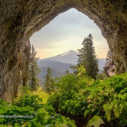
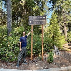
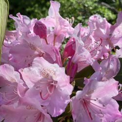
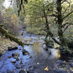
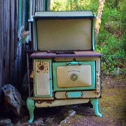
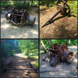
Cancel

    Open app

    Search

    Cascadia State Park

    4.3 (4 reviews)

    Cascadia State Park Parks Photos

    Recommended Reviews - Cascadia State Park

    Your trust is our priority, so businesses can't pay to alter or remove their reviews. Learn more about reviews.
    Yelp app icon
    Browse more easily on the app
    Review Feed Illustration

    6 years ago

    Helpful 0
    Thanks 0
    Love this 0
    Oh no 0

    5 years ago

    Helpful 0
    Thanks 0
    Love this 0
    Oh no 0

    14 years ago

    Helpful 0
    Thanks 0
    Love this 0
    Oh no 0

    4 years ago

    Helpful 0
    Thanks 0
    Love this 0
    Oh no 0

    Verify this business for free

    Get access to customer & competitor insights.

    Verify this business

    Salt Creek Falls - Two waterfalls for the price of one admission...both Salt Creek Falls and Diamond Creek Falls are fantastic.

    Salt Creek Falls

    4.7(12 reviews)
    27.7 mi

    Salt Creek Falls is Oregon's 2nd tallest waterfall, a 286 foot plunge from top to bottom. Visiting…read morehere is easy. It's located right off Highway 58 and 65 miles southeast of Eugene, OR. It's a $5 day use fee. I visited on Labor Day Monday and it wasn't so busy. Once you park, Salt Creek Falls is off to the right hand side but...Diamond Creek Falls (another very worthwhile waterfall to visit) is located towards the left hand side. So...I'd suggest visiting both. You get rewarded with 2 waterfalls for the price of 1 admission. The pathway to Salt Creek Falls Viewpoint is half a mile at most, but along the way there'll be a quick preview of the falls beside the staircase leading towards the trailhead. You can't miss it and you'll hear the falls loudly crashing down below. The hike to the viewing deck is casual. You walk through the forest. It's pretty quiet. Once you arrive at the lookout viewpoint, Salt Creek Falls is impressive. You get undisturbed looks at the waterfall. If your curiosity interests you, you can walk around past the platform for closer glances. I did venture out a little just to avoid the guardrail being in my pictures. But I would say...it's a very steep decline and footing wasn't so secure. Be cautious with your steps. You'll understand this while there. Btw...there were no signs indicating you couldn't venture past the viewing deck. It's up to you to decide how much further you'd like to explore. I noticed some people joined me on the cliffside, while others stayed on the viewing deck. In all, it doesn't take long to see Salt Creek Falls. It's definitely a refreshing breathe of air to be at another marvelous Oregon waterfall, and that's where making the next part of your visit better when you return back to the parking lot and continue onto the 3 mile roundtrip trail to Diamond Creek Falls. I won't say too much about Diamond Creek Falls. I can save it for another review, but I will say it's a complete 180 degree different type of waterfall and setting. You get more into the heart of nature. And you can stand at the base of Diamond Creek Falls looking right up at it cascading in front of your eyes in comparison to witnessing Salt Creek Falls from a vista point platform. They're both unique natural wonders in their own ways. If you're in the central part of Oregon, I'd make plans to come to Salt Creek Falls. I think you'll be pleasantly surprised by two magical looking waterfalls that barely get recognition. I didn't know they existed prior to 2024, and I thought I had been to them all, lol. Goes to show...there always more to see, always more to discover. Getting out among the great outdoors is a beautiful thing.

    Great waterfall viewing here. It's not too far from the parking lot down to the viewing areas…read more There are different viewing areas to go to and get different vantage points. What I liked about this is that they do have accessible viewing areas. Definitely worth going to and having a picnic, hike or both.

    Photos
    Salt Creek Falls
    Salt Creek Falls - If you venture past the Salt Creek Falls observation deck, it'll offer better views for capturing that magical moment.

    If you venture past the Salt Creek Falls observation deck, it'll offer better views for capturing that magical moment.

    Salt Creek Falls - Half mile path through the forest heading to Salt Creek Falls overlook.

    See all

    Half mile path through the forest heading to Salt Creek Falls overlook.

    Abiqua Falls Trailhead - The ropes section of the hike wasn't as daunting as initially feared.

    Abiqua Falls Trailhead

    4.5(11 reviews)
    36.7 mi

    Awesome spot, but you need a good car! Drove a RAV4 to the…read moregate, then walked a short distance. You definitely need a capable car because some uphill parts are rough and slippery (almost lost traction). The hike down is a bit steep and slippery but there are ropes to help. Tip: Bring gloves! After reaching the bottom, just follow the stream to the beautiful waterfall. We had a picnic there and it was so chill. There are no trash cans here,please take your trash with you. I felt like being at a childhood summer camp with the hiking and climbing. The water was too cold to swim this time, but I'll definitely be back during the summer!

    Abiqua Falls! I just visited this beautiful 92-foot waterfall sort of in the middle of nowhere in…read moreOregon but located about 50 miles south of Portland. I have a lot to relay about the experience. This review could take the maximum 5000 words, lol, but I'll try my best to keep things as concise as possible... There are many questions about what to expect from Abiqua Falls. Even myself, I had concerns and doubts. But...I survived and it's an easy adventure to a very secluded waterfall. I'll try and answer the following questions... - Can you drive to the trailhead? From my POV, it's a VERY ROUGH ROAD down to the bottom. There's one specific section (and you'll recognize it immediately) where the road is practically cracked in half with divots and potholes. I actually witnessed a Ford Explorer trying to drive over it on the way back up and it was a big struggle for them! They eventually got past it, but I thought they were stuck. You absolutely need a high clearance 4x4 vehicle to make it down to the base to access the trailhead to Abiqua Falls. For me...I have a Suburu and I parked 2 miles away at the Abiqua Falls "Parking Lot" (according to Google) and then walked 2 miles down to the bottom and 2 miles back up. There was no way I was risking a flat tire, especially with not knowing how to change a tire and there barely being cell phone reception in the area. Btw...just to arrive at the Abiqua Falls parking lot, you must first drive 1.5 miles on a dirt road. For me, dirt and gravel roads are like nails on a chalkboard. I cringe driving over them. - Where is the trailhead located? This is a good question because there's no specific sign for Abiqua Falls, but it's easy to discover. Here's how...the road down to the bottom only goes so far. Eventually, you'll confront a white fence where you can leave your car (if you drove). But...there's a clear opening to the forest on the left-hand side of the road as you're going down. People say it's hard to find, but truly...you can't miss it. If you're any sort of outdoors enthusiast, it's simple. The hike is 7/10ths of a mile out and back. That's it! Again...there's barely any hiking involved, especially if you drive down to the base. - What is the ropes section like on the trail? I must be transparent. I read other people's AllTrails and Google reviews, and this can be deceiving. Let me explain... There were many reviews saying how the ropes section is intense and you're practically repelling down the cliff side. WRONG! WRONG! WRONG! It's an easy pathway. The ropes are no big deal. I have a serious fear of heights, and I casually made my down to the creek. Using the ropes was necessary for the most part, but it wasn't scary. It didn't strain my hands. IT IS NOT STRESSFUL! I'd rate the trail as easy - moderate. Do not fear the incline/decline slope. There's nothing of that sort. It is 100% safe to get up and down the trail. Once down at the bottom of the creek, hang on the left hand side. You'll notice the trail continuing around the bend that leads straight to Abiqua Falls. It's easy. I had no problems at any point in time. I've been on much, much rougher trails during my explorations. I visited on a random Thursday morning at the end of August and pretty much had the falls to myself. There were a few people that came along towards the middle of the day. I believe if you're coming to Abiqua Falls, you must bring a bathing suit and towel. I think it's a right of passage. The waterfall is scenic and the setting is charming, but other than admiring the views and maybe having a picnic, you must take the plunge in the pool of water that Abiqua Falls splashes down into. - Was the water cold? Absolutely! Lol, I was dreading the cold water but made the premeditated decision that I was swimming to have a fun memory. It wasn't even hot outside as well, but I forced myself in and I'm glad I just did it. Obviously, your body adjusts to the cold and it's not too extreme. Overall, the ambiance at Abiqua Falls was liberating. The canyon walls sort of engulf you from high above. You're standing at this dramatic waterfall and when the sun reaches above the tree line, you can notice some slight coloring in the waters which can make for a magical moment. In all, maybe you need a few hours to hang out at the falls before returning to the ropes section and heading back up to the trailhead and road. Again, the hike back up to the top is barely strenuous. It's a slight workout. Most folks can handle it. Lastly, if you're someone who left their car all the way at the top of the road (like I did), it is possible that you may get offered a lift from those hikers who took a chance driving their cars down to the base. If so, hop in, lol. It'll save time not having to trek back uphill. In the end, I enjoyed getting to witness Abiqua Falls. The journey to arrive here was not as daunting as I initially anticipated. And again, from my POV, be kind to your car tires. Don't risk the drive.

    Photos
    Abiqua Falls Trailhead - The trailhead to Abiqua Falls. It's located on the left hand side of the road.

    The trailhead to Abiqua Falls. It's located on the left hand side of the road.

    Abiqua Falls Trailhead - This is Abiqua Falls, a fantastic under the radar  Oregon waterfall.

    This is Abiqua Falls, a fantastic under the radar Oregon waterfall.

    Abiqua Falls Trailhead - Had Abiqua Falls Trail pathway saved on my phone, just in case I got lost.

    See all

    Had Abiqua Falls Trail pathway saved on my phone, just in case I got lost.

    Terwilliger Hot Springs - Beginning of the trail to the springs

    Terwilliger Hot Springs

    3.8(54 reviews)
    20.8 mi

    My partner is a hot springs enthusiast and always seems to have this on his list for how he wants…read moreto celebrate his birthday. The drive out from Portland is long, but after you get here the trip is really enjoyable, we often try to plan a night somewhere closer. It's 12$ for a 2 hour visit, they do take credit cards. We tend to be here mid week mid day so we have not had any issue with parking. There are always other people present, but it has never seemed overly busy. The staff we interact with are always very pleasant. There is a bathroom in the parking lot. It's a short walk up to the hot springs, I'm confident mostly anyone could do this. It's nice to feel like you are in nature. I imagine this was a much more beautiful area before the fires, but I am thankful that it did reopen and is usable. Do make sure you bring some water to stay hydrated while hot springing. Do be aware that sometimes people are unclothed at hot springs. Also know that hot springs are hot and this may not be how you want to spend a hot day. There are multiple pools of multiple sizes which do vary in heat. There is a small stream with cold water running nearby. There are places to sit where you can be partially in the water. If you are planning to walk around a lot you may want water shoes as these rocks can be hot on your feet. We always have a nice time and leave feeling rejuvenated. I keep meaning to look into camping options nearby. I'd love to experience this with some friends on my next visit.

    It was a beautiful drive. It is run by a contractor so no park passes are accepted. I think $12 is…read moretoo much, something around $5 would be more acceptable. There is a 2 hour time limit, I think that is annoying (they mark the time on your receipt that goes on the dash of your vehicle). The parking area is tiny and the chalk lines are far too narrow, difficult to put a normal size car in the lines let alone a truck. There are a LOT of rules. Can't do this, can't do that... on and on. But oh, you don't have to wear clothes. It's just over controlled. There is a really gross toilet at the springs -some sort of belt driven system, yuck, a pit toilet would have been better. There were 26 people there when I got there and it felt crowded. I can't imagine the 50 people they allow, that would be ridiculous. The water was nice and warm. I wouldn't rush to go back.

    Photos
    Terwilliger Hot Springs
    Terwilliger Hot Springs
    Terwilliger Hot Springs

    See all

    Hendricks Park - Entrance to Park

    Hendricks Park

    4.9(38 reviews)
    38.1 mi

    A Beautiful Return to a Place Full of Nature and History…read more Both my wife and I had visited this spot before when we lived in the area, so with a little time to spare before lunch nearby, we decided to revisit it with her son and daughter-in-law. Nestled on a forested butte just east of the University of Oregon in Eugene, this area is absolutely stunning. The rhododendron garden is especially beautiful, offering a peaceful and scenic escape that feels tucked away from the city. Beyond its natural beauty, the area is steeped in history. One of the most notable connections is to Steve Prefontaine--a legendary runner and seven-time NCAA champion for Oregon. He trained in and around Hendricks Park and tragically passed away in a car accident on a winding road just below the park. His legacy lives on not only in the running world but also in the early success of Nike, where he became the brand's first sponsored athlete and helped elevate it to global prominence. Whether you're a nature lover, a history buff, or just looking for a quiet place to explore, this area is well worth a visit.

    Hendricks Park is one of those places that I knew was around town, but never visited until after I…read moremoved away and came back to visit. I grew up in the Cal Young area or Santa Clara, so I wasn't very often in this part of town and though Eugene isn't a huge city, you can easily not hit other areas of town. Hendricks Park is the oldest park in the city. It's mostly known as a rhododendron garden, but it has native plants as well. There are trails throughout for you to explore the place. It's really peaceful and beautiful when the weather is nice, and you'll forget you're in the city.

    Photos
    Hendricks Park
    Hendricks Park
    Hendricks Park

    See all

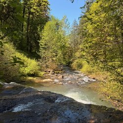
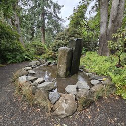
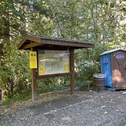
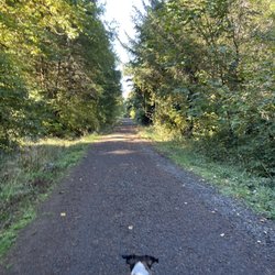
    Cascadia State Park - parks - Updated June 2026

    Loading...
    Loading...
    Loading...