Cancel

    Open app

    Search

    Cedar Creek Swimming Pool

    5.0 (1 review)

    Cedar Creek Swimming Pool Photos

    You might also consider

    More like Cedar Creek Swimming Pool

    Recommended Reviews - Cedar Creek Swimming Pool

    Your trust is our priority, so businesses can't pay to alter or remove their reviews. Learn more about reviews.
    Yelp app icon
    Browse more easily on the app
    Review Feed Illustration

    2 years ago

    Fun and convenient! We really like the easy-going nature of this pool too! Thank you so much for being here!

    Helpful 0
    Thanks 0
    Love this 0
    Oh no 0

    Verify this business for free

    People searched for Swimming Pools 207 times last month within 15 miles of this business.

    Verify this business

    Lake Sidney Lanier

    Lake Sidney Lanier

    4.3
    (26 reviews)
    45.8 mi

    A hidden staycation opportunity that flies under the radar. Known for their boating and lake…read moreactivities but the other side offers a relaxed environment. Lodge/hotel lodging with spacious rooms with the treat of a Keurig in each room. A truly heated pool with poolside service or indoor or patio eating. Onsite restaurant with outdoor lake views offering buffet breakfast and menu dinners. A coffee nook offering fresh coffee/lattes along with patries. The topper is an onsite spa. Plenty of options on the property with golf, pickle ball, game room and water park.
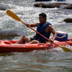
    I'm very surprised Lake Lanier has so few reviews. After all, it was one of the water sport venues…read moreof the 1996 Olympics, one of the most popular summertime destinations in the state. Most any warm season holiday is celebrated at Lake Lanier making it a popular place for vacation rental homes. Here you can go boating, fishing, swimming, hiking, golfing, as well as experience a fabulous fireworks show in the summer or Christmas lights and snow sleds in the winter. There is a spa, a beach, a waterpark, a luxury resort and good times @ Margaritaville. You can rent jet skis, go horseback riding, charter a fishing boat, rent a house boat, go camping or take a hot air balloon ride nearby. It was created by the completion of Buford Dam on the Chattahoochee River in 1956, and named for Confederate Army poet Sidney Lanier. Its primary purpose was for flood control and water supplies and has a water volume of about 1,049,400 acre-ft. The narrative will tell you its construction destroyed more than 50,000 acres of farmland and displaced more than 250 families, 15 businesses, and relocated 20 cemeteries along with their corpses in the process. But I want to pause here and dive a little deeper under the surface of its waters and introduce you to: [ OSCARVILLE, GEORGIA ] "The truth is rarely pure and never simple." ― Oscar Wilde Lake Lanier is partially located in Forsyth county. It is a county that prided itself on not having black residence so much that Oprah came to film an episode of her Emmy Award-winning talk show here in 1987 (trigger warning): https://www.youtube.com/watch?v=WErjPmFulQ0 The show makes mention that "no black person had lived in the county for 75 years", which was a direct reference to a predominantly African-American community known as Oscarville. It was home to 1,100 black people prior to a racial conflict in 1912 which was so brutally violent that it caused blacks to flee the county... even those who were landowners. "According to Elliot Jaspin, a historian and journalist quoted by the Digital Library of Georgia and the New Georgia Encyclopedia, only about 24 of the nearly 40 Black landowners in Forsyth County at the time were able to sell their land. The other properties have no record of sale, and some believe the abandoned land was simply taken by White residents." - The Times Oscarville began as a small farming town around 1870, but after so many fled the county in 1912, it was practically a ghost town. Those still claiming ownership of their land either had it seized or were "asked" to to forfeit their land to build the Buford Dam by Newport Dam Development according to an article published on April 6, 2021 by The Signal. Prior to the violence, Oscarville was actually known for its agricultural prowess in fighting off the boll weevil infestation that hindered many farm crops and enriching the soil with chicken feces. A technique that has been duplicated to this day to revive poor farming/gardening soil. "Facts do not cease to exist because they are ignored." ― Aldous Huxley [ MUST WATCH ] Link to Oscarville | The Town Submerged by Lake Lanier (Intrigued Mind): https://www.youtube.com/watch?v=ifMKfBO_R6s [ FINAL THOUGHTS ] Lake Lanier is a beautiful lake and a rich resource for Atlanta. It provides approx. 70% of the drinking water for Metro Atlanta as well as power, recreation and businesses. But there is more than what meets the eye as you look across its glistening surface. An entire town is buried by its waters and has been nearly forgotten, and the hard truth is this is not an isolated story. There are several other towns across the country who suffered the same fate. They include: Kowaliga (Benson), Alabama Seneca Village In New York City Susannah, Alabama and Vanport, Oregon The story of Lake Lanier and Oscarville will be featured in an upcoming TV series called Oscarville - Below the Surface. Here is the link to the trailer: https://www.youtube.com/watch?v=yVux8Y96cok Thanks for reading. 2022 / 59 #BlackHistorySeries

    Photos
    Lake Sidney Lanier
    Lake Sidney Lanier
    Game room

    See all

    Game room
    Riley Moore Falls

    Riley Moore Falls

    5.0
    (4 reviews)
    57.0 mi

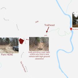
    I just wanted to update my 3/15/20 review below to add I've now done this hike several times, but…read moreTHIS time I had the chance to hike it with a friend who is directly related to the namesake of the waterfall... Riley Moore. Sandie is a church friend of mine and Riley Moore was her Great Great Uncle (I believe that's right). He once upon a time operated a grist mill here at the top of the falls. She's been trying to get here to see the waterfall, but couldn't find it and wanted to join us (along with her family) since I knew the way. Upon further research I discovered there are actually still remnants of the mill including visible drill holes, spikes and bolts. Thought that was pretty cool info to share! [ [ [ PREVIOUS REVIEW ] ] ] Riley Moore Falls is small in height but HUGE in personality. It's located off State Road S37-748, which is a nicely maintained gravel road where cars and trucks alike can comfortably traverse. ~~~ DIRECTIONS From Westminster, SC - DO NOT turn onto Cobb Bridge Road from Long Creek Hwy (Hwy 76) where you will see the brown & white sign pointing you in the direction of Riley Moore Falls. Our GPS had us go this way, then left onto State Road S37-748, but the road was CLOSED during our visit! INSTEAD, turn onto PU-32 also known as Rocky Fork Road. Turn left onto a gravel road near Rocky Fork Baptist Church and follow that until it dead ends @ State Road S37-748 (also known as Spy Rock Road). Turn right and drive approx. 1.4 miles (4 minutes) to 748c (aka Riley Moore Shoals Road). Park at the intersection of State Road S37-748 and 748c. DO NOT ATTEMPT TO DRIVE 748c in a car or minivan. Low clearance vehicles will find the terrain on this road to be VERY difficult to navigate without bottoming out or getting stuck. I'd also recommend 4x4 capability on wet days! There can be several deep-pocketed muddy areas after heavy rains. ~~~ THE TRAIL Once you reach the intersection of Spy Rock Rd (S37-748) and 748c, park roadside on Spy Rock, secure your vehicle and begin your hike approx. 1/2 mile down the "primitive road." IF you have a high ground clearance SUV or truck, you can drive the primitive road another half mile or so to a second parking area near the trailhead. The primitive road is VERY BUMPY  and can be muddy in spots after heavy rains, so a 4x4 is best. After reaching the second parking area, follow the marked trail on the left!!! The trail is a little over a 1/2 mile to the falls from here. The trail is fairly straightforward and easy to follow. ~~~ THE FALLS Once you reach the Chauga River, you will notice a large sandy area with plenty of room for an entire horde of hikers!!! Riley Moore Falls is not very tall (only about 12 feet), but it is very wide and has a deep base pool. PRO TIP - Bring swimwear, towels and a picnic, but be sure to pack it in and pack it out. ~~~ THINGS TO KNOW Hiking Distance: 2 miles (round trip to falls from S37-748) Difficulty of hiking 748c: All downhill to trailhead (moderate return) Difficulty of hiking trail to falls: EASY Creek Crossings: NO Elevation Gain: 357 feet Waterfall Height: Approx 12 feet Access to top of falls: NO - not without getting wet Access to base of falls: YES Pool of water @ base of Falls: YES Sitting areas @ base: YES + sandy beach RESTROOMS: NO PARKING: YES (along road) + secondary parking area closer to trailhead for trucks and high ground clearance vehicles with room for about 6 cars. ~~~ [ FINAL THOUGHTS ] A lovely waterfall in any season, but also a great spot for a summer swim. While we had the waterfall practically to ourselves during our Mid-March expedition, be advised other trail website reviews say it gets trashy & crowded in summer months. What a shame if that is true because it truly is a treasure. ENJOY! 2022 / 74 #UPDATE 178

    This is the best waterfall we got to visit in SC this far. After we left Reedy Branch Falls we…read moredrove here. Well, as close as we could get. I didn't realize that we couldn't drive all the way to the trailhead so we had a long hike in store due to me having to carry my toddler most of the time. I should have re-read the previous reviews before coming. My friend did help me carry her as well and for that I was very thankful. So definitely don't recommend this hike with a little one unless strapped in a carrier. Also, I don't recommend it for the elderly either. It's definitely a wilderness hike deal with roots and elevation change. In fact, it's mostly downhill on the way to the falls, but on the way back it's pretty much all uphill, which was not fun with aforementioned young child. It's about a half mile to the actual trailhead and then another 0.7 mile to the falls. That's about 2.4 miles round trip. The reason of course that my boys absolutely became enamored with this place is the large swimming hole. It is wonderful and has plenty of space. The waterfall itself is beautiful and although it's not as tall as others, its width is quite impressive. I was trying to get as close as I could and even noticed a hidden part of the falls inside of the rock structure. That was so cool!! The sand at the base and shore give it a beachy vibe. We definitely packed it in and out making sure not to leave anything behind as to preserve the area as best as possible. Needless to say we were wiped by the time we made it back to our vehicles, but we're still glad we decided to venture here. Coming back with my hubby and boys in the very near future. Happy yelping!

    Photos
    Riley Moore Falls
    CREATED FROM GOOGLE MAPS
    CREATED FROM GOOGLE MAPS
    Riley Moore Falls

    See all

    Watson Mill Bridge State Park

    Watson Mill Bridge State Park

    4.4
    (17 reviews)
    15.8 mi

    Wonderful morning on the trails for a group hike! We did two loops…read more The trails are well maintained and clearly marked. There are some inclines, making it a moderate hike. Several people enjoyed the sliding rocks and waterfall afterward. Great outing for family and/or friends .

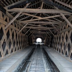
    On this rainy and chilly Sunday morning the park felt almost suspended in its own quiet, the kind…read moreof stillness you only get when the weather keeps everyone else home and you end up with the place to yourself. No one was camping or fishing or wandering the grounds (though I did see one park ranger pickup truck on patrol), which meant I had time with the real centerpiece of the park, the Watson Mill Covered Bridge, and the soft sound of the river underneath it carried farther than usual in the damp air. The bridge was built in 1885 by W. W. King, one of Georgia's most skilled nineteenth century bridge builders, and it remains the longest existing covered bridge in the state at 236 feet. It uses the Town lattice truss system, a design patented in 1820 that relies on a crisscross pattern of planks secured with wooden pegs, and Watson Mill is one of the best surviving examples of that method in the Southeast. The bridge once served the workers of the grist mill and sawmill that stood nearby, and it doubled as a community gathering place where people held picnics and even square dances. The Georgia Department of Transportation restored it in 1973, and the bridge became the anchor for the surrounding state park, which preserves both the structure and the landscape that supported it. The posted clearance was too low for my Sprinter van so I walked the length of the bridge instead, letting the boards creak underfoot and taking in the smell of wet timber that always feels older than the structure itself. There is no dedicated pedestrian lane, but the interior is wide enough that I could step to the side when a car approached, and the drivers moved slowly enough that it never felt unsafe. The combination of the rain, the quiet, and the long wooden tunnel made the whole experience feel like stepping back into the late nineteenth century for a few minutes. [Review 245 of 2026 - 942 in Georgia - 25434 overall]

    Photos
    Playground
    Playground
    Watson Mill Bridge State Park, Comer
    Watson Mill Bridge State Park, Comer
    Watson Mill Bridge in Watson Mill Bridge State Park, Comer

    See all

    Watson Mill Bridge in Watson Mill Bridge State Park, Comer
    Van Pugh Park

    Van Pugh Park

    4.0
    (14 reviews)
    42.1 mi

    We came out this way for day camping, which I didn't know was a thing. The South Park is for day…read moreuse and North is for camping. It was July 3rd and 4th, so busy weekend. We had an issue with my son getting in due to the park rangers and police closing entry. It was full and they turned my son around by accident. However, I don't think he let them know he had a reservation. That's the reason for my star bump but both the police officer and ranger were apologetic, so much appreciated. Day camping is a new thing for me. For $15/day, you can rent a site from 8AM to 8PM. They have running water and electricity. There are also two bathroom facilities with showers. The day use spots are good for two vehicles and have a picnic table and trash bag hanger. Easy access to the water in most spots. They have two grills to cook at the sites. It's very much worth the money. They don't allow alcohol, pets or really loud music. The beaches are nice and water is pretty clear. The coves make it easy for swimming. I do recommend!

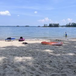
    What a great place for a day outing or a week long stay on the clear waters of Lake Lanier…read more Facilities are what you expect from a Georgia State Park ..... excellent! Proximity to some of the islands makes it a great place to kayak from without to much worry from boats and jet skis. Although our time spent here is during the week I imagine the lake can be somewhat hazardous on weekends with boats everywhere. Regardless it is a great spot to spend time in the warm waters and just relax. One of our favorite Georgia spots.

    Photos
    Van Pugh Park
    Van Pugh Park
    Pan of the beach

    See all

    Pan of the beach

    Cedar Creek Swimming Pool - swimmingpools - Updated August 2026

    Loading...
    Loading...
    Loading...