Chehalem Ridge Nature Park Photos


You might also consider
More like Chehalem Ridge Nature Park
Recommended Reviews - Chehalem Ridge Nature Park
Start your review...

Reviews With Photos

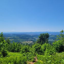
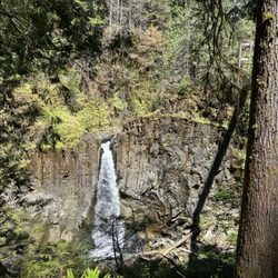
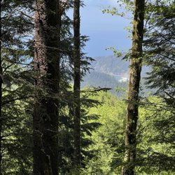
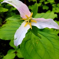
What a discovery!! We were staying in Forest Grove and happened upon this Nature Preserve. We weren't really in appropriate hiking/walking attire, but what the heck, we wanted to check it out. Great signage, maps, park art. They had trail maps at every trail intersection. I kept commenting on how well it was maintained, later learning it's a pretty new park. We didn't really see many people, we did see evidence of horses but none on the trails. We hiked 6 miles - there just a lot to explore. Pretty views of the countryside and mountains nearby. Very calming. We loved every minute!!

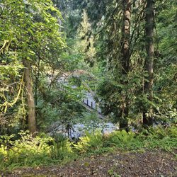
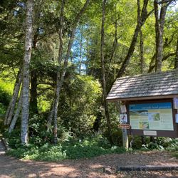
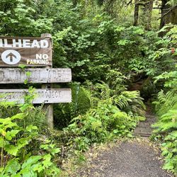
This is still listed as a new Park. Never had it's grand opening celebration due to two years of Covid. Well all that comes to an end this month. I believe the 17th will be a party by Metro to attract people and let them know the park is open for business. Great picnic pavilions all new and clean. Easily accessible for parties and picnics. Plenty of space to have a good time Nice new bathrooms well maintained and clean for now. The paths are all well marked with maps and direction signs at every turn. Hard to get lost for sure. There are also paths for horses and bikes so be prepared as you cross these paths to share the space. We didn't see anyone or any horse parties. Although they left evidence of their presence behind. Watch where you step. Every viewpoint is worth the extra effort to get there. Presenting different almost 360 views as you hit each one. Definitely recommend visiting them all. The trails are kind of medium skill set. Mostly gravel. There are a couple time ayou cross the old logging road where it can get muddy and slippery uphill. Nothing too challenging just those spots where extra care is needed. A nice place to get into the woods and have a little peace and quiet.

10 months ago
Great day for a hike and Chehalem Ridge didn't disappoint. Plenty of parking, clean restrooms, and some very nice views. I'll be going back. read more


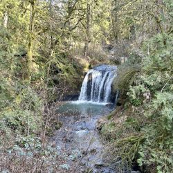
Beautiful park with tree covered trails and wide paths. We did the woodland trail then continued up Timber Road and onto the Chehalem Ridge trail. Path was mostly flat with slight inclines here and there until you got to Timber Road, this was really the only tougher incline, mostly because it was out in the direct sun. The scenery was beautiful forrest and ferns, with a couple viewpoints out to the hills in the distance. Directional signage on the trials was pretty good, didn't notice any maps aside from the one at the entrance, but at least you could see when trail intersected and which way to go for each. We came on a Friday afternoon, the parking was plentiful and we almost had the trial to ourselves. There are two covered picnic areas at the trailhead, both had a handful of picnic tables and benches. Beware - we were chased off by yellow jackets while trying to enjoy our lunch. We were there on a pretty warm day, so they seemed to be extra active. Restrooms at the trailhead were spacious and clean. read more


Fabulous! Great parking and facilities, including covered picnic tables and clean restrooms. There are a variety of trails, most multi-use. The trails are signed and maintained well and the grounds were clean everywhere we roamed. It's easy to make yourself a path of any length needed, as the trails cross-cross often with minor elevation changes but nothing steep. We were impressed...a beautiful and peaceful shady trail system! read more


4 years ago
What a discovery!! We were staying in Forest Grove and happened upon this Nature Preserve. We weren't really in appropriate hiking/walking attire, but what the heck, we wanted to check it out. Great signage, maps, park art. They had trail maps at every trail intersection. I kept commenting on how well it was maintained, later learning it's a pretty new park. We didn't really see many people, we did see evidence of horses but none on the trails. We hiked 6 miles - there just a lot to explore. Pretty views of the countryside and mountains nearby. Very calming. We loved every minute!! read more


This is still listed as a new Park. Never had it's grand opening celebration due to two years of Covid. Well all that comes to an end this month. I believe the 17th will be a party by Metro to attract people and let them know the park is open for business. Great picnic pavilions all new and clean. Easily accessible for parties and picnics. Plenty of space to have a good time Nice new bathrooms well maintained and clean for now. The paths are all well marked with maps and direction signs at every turn. Hard to get lost for sure. There are also paths for horses and bikes so be prepared as you cross these paths to share the space. We didn't see anyone or any horse parties. Although they left evidence of their presence behind. Watch where you step. Every viewpoint is worth the extra effort to get there. Presenting different almost 360 views as you hit each one. Definitely recommend visiting them all. The trails are kind of medium skill set. Mostly gravel. There are a couple time ayou cross the old logging road where it can get muddy and slippery uphill. Nothing too challenging just those spots where extra care is needed. A nice place to get into the woods and have a little peace and quiet. read more


4 years ago
Beautiful trails. Good little hiking workout. All flat. Pretty views. A few lil critters too. read more


4 years ago
3 years ago
More info about Chehalem Ridge Nature Park
38263 SW Dixon Mill Rd
Gaston, OR 97119
Directions
Visit Website
https://www.oregonmetro.gov
Hours
Outdoor Amenities
Ask the Community - Chehalem Ridge Nature Park


Chehalem Ridge Nature Park - hiking - Updated June 2026
Best of Gaston
People found Chehalem Ridge Nature Park by searching for…
Hiking Trails in Gaston, Oregon
River Swimming in Gaston, Oregon
Picnic Areas in Gaston, Oregon
Flower Fields in Gaston, Oregon
Walking Trails in Gaston, Oregon
Watch Sunset in Gaston, Oregon
Scenic Overlook in Gaston, Oregon
Scenic Views in Gaston, Oregon
Off Road Trails in Gaston, Oregon
Places to Take Pictures in Gaston, Oregon
Sunrise View in Gaston, Oregon
Secret Spots in Gaston, Oregon
Waterfall Hike in Gaston, Oregon
Off Leash Dog Hikes in Gaston, Oregon
Fun Things to Do at Night in Gaston, Oregon
Park With BBQ Pits in Gaston, Oregon
Beach Camping in Gaston, Oregon
Trending Searches in Gaston, OR
Baseball Fields near Chehalem Ridge Nature Park
Beaches near Chehalem Ridge Nature Park
Boardwalk near Chehalem Ridge Nature Park
Boat Rental near Chehalem Ridge Nature Park
Cliff Jumping near Chehalem Ridge Nature Park
Day Trips near Chehalem Ridge Nature Park
Dog Friendly Beaches near Chehalem Ridge Nature Park
Dog Friendly Trails near Chehalem Ridge Nature Park
Fishing Spots near Chehalem Ridge Nature Park
Free Kids Activities near Chehalem Ridge Nature Park
Free Picnic Areas near Chehalem Ridge Nature Park
Jet Ski Rental near Chehalem Ridge Nature Park
Kayak Rental near Chehalem Ridge Nature Park
Kids Activities Outdoor near Chehalem Ridge Nature Park
Lakes near Chehalem Ridge Nature Park
Lakes & Ponds near Chehalem Ridge Nature Park
Off Road Trails near Chehalem Ridge Nature Park
Outdoor Activities near Chehalem Ridge Nature Park
Outdoor Basketball Courts near Chehalem Ridge Nature Park
Paddle Boat Rentals near Chehalem Ridge Nature Park
Parks With Pull Up Bars near Chehalem Ridge Nature Park
Pick Your Own Farms near Chehalem Ridge Nature Park
Places To Walk Around near Chehalem Ridge Nature Park
Public Shower near Chehalem Ridge Nature Park
Rock Quarry near Chehalem Ridge Nature Park
Scenic Drive near Chehalem Ridge Nature Park
Scenic Night View near Chehalem Ridge Nature Park
Secluded Spots near Chehalem Ridge Nature Park
Soccer Store near Chehalem Ridge Nature Park
Splash Pad near Chehalem Ridge Nature Park
Strawberry Picking near Chehalem Ridge Nature Park
Sunrise View near Chehalem Ridge Nature Park
Swimming Holes near Chehalem Ridge Nature Park
Swimming Lakes near Chehalem Ridge Nature Park
Swimming Pools near Chehalem Ridge Nature Park
View Fireworks near Chehalem Ridge Nature Park
Watch Sunset near Chehalem Ridge Nature Park
Browse Nearby
BEST of Gaston, Oregon Restaurants near Chehalem Ridge Nature Park
BEST of Gaston, Oregon Things to Do near Chehalem Ridge Nature Park
BEST of Gaston, Oregon Coffee near Chehalem Ridge Nature Park
BEST of Gaston, Oregon Breakfast near Chehalem Ridge Nature Park
BEST of Gaston, Oregon Wineries near Chehalem Ridge Nature Park
Browse Brands
Related Searches in Gaston, OR
Best Fishing Locations and Guides in Gaston, Oregon
Best Lookout Points to Visit in Gaston, Oregon
Best Nature Trails for Hiking in Gaston, Oregon
Best Places for Horseback Riding in Gaston, Oregon
Best Spots for Star Gazing in Gaston, Oregon
Best Waterfalls and Swimming Holes in Gaston, Oregon
Check Out Off Road Trails in Gaston, Oregon
Discover Dog Friendly Trails to Explore in Gaston, Oregon
Discover Popular Bike Trails in Gaston, Oregon
Discover Popular Photo Spots in Gaston, Oregon
Discover Scenic Mountain Bike Trails Near Gaston, Oregon
Discover Stunning Skyline View Spots in Gaston, Oregon
Discover Top Boat Tours in Gaston, Oregon for All Ages
Discover Top Nature Parks to Visit in Gaston, Oregon
Discover a Hiking Trail in Gaston, Oregon
Discover the Best Beaches in Gaston, Oregon
Discover the Best Night Hike Trails in Gaston, Oregon
Dog-Friendly Hikes With Dogs in Gaston, Oregon
Effective Stairs Workout Spots in Gaston, Oregon
Enjoy Fishing Pier Spots in Gaston, Oregon With Scenic Views
Enjoy a Beautiful Waterfall Hike in Gaston, Oregon
Enjoy the Best Night View Spots in Gaston, Oregon
Enjoy the Best Walking Trails in Gaston, Oregon
Exciting Cliff Jumping Spots in Gaston, Oregon
Experience Stunning Sunset Views in Gaston, Oregon
Explore Beautiful Parks and Green Spaces in Gaston, Oregon
Explore Easy Hikes Perfect for All in Gaston, Oregon
Explore Free Picnic Areas Around Gaston, Oregon
Explore Landmarks & Historical Buildings in Gaston, Oregon
Explore Parks With Pull Up Bars in Gaston, Oregon
Explore Popular Campgrounds Near Gaston, Oregon
Explore Popular RV Parks Around Gaston, Oregon
Explore Popular Scenic Overlook Points in Gaston, Oregon
Explore Popular Scenic Views Near Gaston, Oregon
Explore Popular View Points Around Gaston, Oregon
Explore Secret Spots Worth Visiting in Gaston, Oregon
Explore Summer Camps for All Ages in Gaston, Oregon
Explore Top Gyms in Gaston, Oregon Now
Explore Top Water Parks in Gaston, Oregon Today
Explore the Best Boating Spots in Gaston, Oregon
Explore the Best Swimming Holes Around Gaston, Oregon
Explore the Best Trail Options in Gaston, Oregon
Find Cozy Camping Cabins in Gaston, Oregon
Find Parks and Recreation Activities in Gaston, Oregon
Find Popular Ziplining Spots Around Gaston, Oregon
Find Top-Rated Waterfalls in Gaston, Oregon Now
Find the Best Scenic View Locations in Gaston, Oregon
Hiking Trails With Waterfalls in Gaston, Oregon
Browse Articles
People who viewed Chehalem Ridge Nature Park also viewed
Graham Oaks Nature Park
17 reviews
Bald Peak State Scenic Viewpoint
6 reviews
Lowami Hart Woods Natural Area
9 reviews
Rock Creek Trail
12 reviews
Tualatin Hills Nature Park & Recreation District
102 reviews
Fernhill Wetlands
12 reviews
Chief Kno-Tah at Shute Park
7 reviews
LL Stubb Stewart State Park
18 reviews
Fanno Creek Trail
10 reviews
Waterhouse Park
5 reviews