Columbia Rock Photos


You might also consider
More like Columbia Rock
Recommended Reviews - Columbia Rock
Start your review...

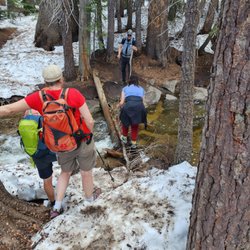
Awesome trail! It was one hell of a hike going up and zig zagging but the views are absolutely breathtaking views! Worth every step! If you keep going you will head towards Upper Yosemite Falls. I believe that is what we were told. Which we will be doing next month lol fun times! You cannot beat the views on this trail. The views are spectacular--everything Yosemite is about. You shouldn't be too afraid of heights either. We made it in time to experience the Firefall phenomenon! EPIC! read more


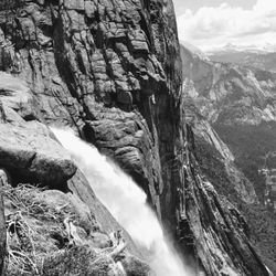
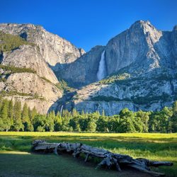
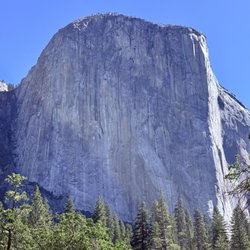
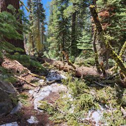
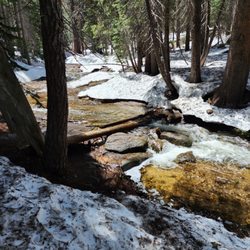
We were looking for a short, moderately strenuous, and view rewarding hike. Found at this Columbia Rock viewpoint via Upper Yosemite Falls trail. Distance is about 2 miles round trip, all switchbacks, and about 1,000 ft elevation. Our entire hike took about 2 hours, including a long break at the famous viewpoint,180 degrees views of Yosemite Valley with Half Dome. 32 oz water required for Winter and Spring, 64 oz wafer required for Summer and Fall. We started the trail from Camp 4, bathrooms avail there. Saw lots of climbers practicing their sport. I also saw a plaque listing Camp 4 as a National Register of Historic Places for the growth and development of rock climbing. Later, I read that Camp 4 is one of 3 most famous climbing base camps on earth, along with Everest Basecamp, and Chamonix by Mont Blanc. Look for Midnight Lightning, a chalk lightning bolt drawn on a super difficult concave shaped boulder. read more


More info about Columbia Rock
Yosemite Falls Trl
Yosemite Valley, CA
Directions
Hours
Outdoor Amenities


Columbia Rock - parks - Updated June 2026
Best of Yosemite Valley
People found Columbia Rock by searching for…
Hiking in Yosemite Valley, California
Campgrounds in Yosemite Valley, California
National Parks in Yosemite Valley, California
Picnic Areas in Yosemite Valley, California
Things to Do in Yosemite Valley, California
State Park in Yosemite Valley, California
Camping Sites in Yosemite Valley, California
Trails in Yosemite Valley, California
Hiking Trails in Yosemite Valley, California
Scenic Overlook in Yosemite Valley, California
Scenic View in Yosemite Valley, California
Picnic Areas BBQ Pits in Yosemite Valley, California
Swimming Holes in Yosemite Valley, California
Playgrounds in Yosemite Valley, California
Viewpoints in Yosemite Valley, California
Camping With Showers in Yosemite Valley, California
Public Showers in Yosemite Valley, California
Picnic Tables in Yosemite Valley, California
Picnic Spots in Yosemite Valley, California
Fishing Spots in Yosemite Valley, California
Camping Cabins in Yosemite Valley, California
Free Overnight Parking in Yosemite Valley, California
Trending Searches in Yosemite Valley, CA
Bait And Tackle Shop near Columbia Rock
Boat Rental near Columbia Rock
Cliff Jumping near Columbia Rock
Dog Friendly Beaches near Columbia Rock
Fishing Spots near Columbia Rock
Jet Ski Rental near Columbia Rock
Kayak Rental near Columbia Rock
Pick Your Own Farms near Columbia Rock
Public Pools near Columbia Rock
Strawberry Picking near Columbia Rock
Swimming Holes near Columbia Rock
Swimming Lakes near Columbia Rock
Browse Articles
Browse Nearby
BEST of Yosemite Valley, California Playgrounds near Columbia Rock
BEST of Yosemite Valley, California Picnic Areas near Columbia Rock
BEST of Yosemite Valley, California Restaurants near Columbia Rock
BEST of Yosemite Valley, California Things to Do near Columbia Rock
BEST of Yosemite Valley, California Coffee near Columbia Rock
BEST of Yosemite Valley, California Breakfast near Columbia Rock
BEST of Yosemite Valley, California Campgrounds near Columbia Rock
BEST of Yosemite Valley, California Gold Panning near Columbia Rock
BEST of Yosemite Valley, California Sledding near Columbia Rock
Browse Brands
Related Searches in Yosemite Valley, CA
Best Fun Things to Do in Yosemite Valley, California
Best Parks for Parties and Events in Yosemite Valley, California
Best Water Parks for Kids in Yosemite Valley, California
Check Out Great Playgrounds in Yosemite Valley, California
Discover Baseball Fields Around Yosemite Valley, California
Discover Popular Photo Spots in Yosemite Valley, California
Discover Top Nature Parks to Visit in Yosemite Valley, California
Discover the Best Beaches in Yosemite Valley, California
Enjoy the Best Picnic Spots and Ideas in Yosemite Valley, California
Enjoy the Best Walking Trails in Yosemite Valley, California
Explore Beautiful Botanical Gardens in Yosemite Valley, California
Explore Easy Hikes Perfect for All in Yosemite Valley, California
Explore Family-Friendly Zoos and Wildlife in Yosemite Valley, California
Explore Free Picnic Areas Around Yosemite Valley, California
Explore Fun Activities to Do in Yosemite Valley, California
Explore Parks With Pull Up Bars in Yosemite Valley, California
Explore Popular Campgrounds Near Yosemite Valley, California
Explore Popular Picnic Areas Around Yosemite Valley, California
Explore Popular RV Parks Around Yosemite Valley, California
Explore Popular Recreation Centers Around Yosemite Valley, California
Explore Popular Scenic Views Near Yosemite Valley, California
Explore Scenic Lakes to Visit in Yosemite Valley, California
Explore Summer Camps for All Ages in Yosemite Valley, California
Explore Top Dog Parks in Yosemite Valley, California Near You
Explore Top Gyms in Yosemite Valley, California Now
Explore Top Water Parks in Yosemite Valley, California Today
Find Parks and Recreation Activities in Yosemite Valley, California
Find Picnic Tables for Outdoor Fun in Yosemite Valley, California
Find Top Skate Parks in Yosemite Valley, California for All Skill Levels
Find Top Skating Rinks in Yosemite Valley, California for All Ages
Find Top-Rated Waterfalls in Yosemite Valley, California Now
Find the Best Parks BBQ Grills in Yosemite Valley, California
Find the Best Parks for Picnics in Yosemite Valley, California
Have Fun at a Splash Pad in Yosemite Valley, California
Indoor Playgrounds to Explore in Yosemite Valley, California
Locate a Public Shower Facility in Yosemite Valley, California
Must-See Tourist Attractions Around Yosemite Valley, California
Parks With Basketball Courts for Games in Yosemite Valley, California
Picnic Areas With BBQ Pits Available in Yosemite Valley, California
Popular Fishing Spots to Explore in Yosemite Valley, California
Popular Kids Activities in Yosemite Valley, California
Popular Things to Do in Yosemite Valley, California
Popular Things to See in Yosemite Valley, California
Top Hiking Trails to Explore in Yosemite Valley, California
Top Running Trails to Explore in Yosemite Valley, California
Top Swimming Lakes to Enjoy in Yosemite Valley, California
Top-Rated Basketball Courts to Play at in Yosemite Valley, California
Top-Rated Hikes in Yosemite Valley, California to Explore
Visit Popular Museums in Yosemite Valley, California Now
Walk Dog Friendly Hiking Trails in Yosemite Valley, California