Cancel

    Open app

    Search

    Dawkins Line Rail Trail

    3.0 (2 reviews)

    Dawkins Line Rail Trail Photos
    Recommended Reviews - Dawkins Line Rail Trail

    Your trust is our priority, so businesses can't pay to alter or remove their reviews. Learn more about reviews.
    Yelp app icon
    Browse more easily on the app
    Review Feed Illustration

    6 years ago

    Helpful 5
    Thanks 0
    Love this 2
    Oh no 0

    4 years ago

    Helpful 1
    Thanks 1
    Love this 0
    Oh no 1

    Verify this business for free

    Get access to customer & competitor insights.

    Verify this business

    Quiet Trails State Nature Preserve - Licking River.

    Quiet Trails State Nature Preserve

    4.5(2 reviews)
    92.1 mi

    Quiet Trails was my find of the year!…read more I am hesitant to write a review because putting it on the Yelp map might make it a little less secretive. I only found out about this place through word of mouth from a few friends as there is very little information online. For the locals in Harrison County, Quiet Trails has been a popular hiking spot along the Licking River. This year-round hiking trail loops 1.7 miles down to the river and back up. The loop is actually two different trails that meet up at the same point - so you can choose to go down and up the same path, or go back on the other path. We initially choose what we thought was the more difficult path (Challenger Trail) to get down to the river, and the 'easier' path back up -- but I think it should have been marked the other way around. One path is rather wide and easy to see -- the other (Deep Hollow) is very narrow and goes through some very steep areas. While some areas are clearly the path, some parts were a little bit harder to see and we had to use intuition to figure out which way to go. Yet, it is a stunningly gorgeous hike, especially on the Deep Hollow path. We were told that it would be an easy, short hike. It wasn't easy or short at all with a toddler that wanted to be carried nearly the entire time. Once we got to the river, we had a little bit of a break as he wanted to wade and splash, but we were eager to get out of the heat and back in the car. By the end of the hike, my back was so sore (can you guess who carried the kid most of the time?). We will try to come back when my child is a bit older and more willing to walk himself, or just without him on a day date. If your kids are used to hiking or over the age of five, they will most likely be fine. Also, the GPS will take you here -- but be prepared to be a bit confused as you drive through back roads to find this place. The little gravel pull-off [parking lot] with the gate and a small sign is actually the entrance to the preserve. You'll have to shimmy through the fence to get to the paths. We were so confused if we were even in the right place until we saw a person that was a seasoned hiker in this area. Thank goodness! Oh, and bring a stick to knock down some spider webs. I'm excited to come back here next summer and do more hiking!

    This is a nature preserve and doesn't allow dogs, including on a leash. There is a large sign at…read morethe start of the trail. It's a lovely area and the trail looked promising.

    Photos
    Quiet Trails State Nature Preserve
    Quiet Trails State Nature Preserve

    See all

    Edge of Appalachia Preserve

    Edge of Appalachia Preserve

    5.0(2 reviews)
    76.1 mi

    Great all around destination for a hike. Trails are well maintained, and the Buzzardroost Rock…read moretrail was a good out and back with some variety, about 4.5 miles overall. Glad we arrived early in the morning due to the Summer heat, but also because once we arrived at the overlook, the fog was moving through the mountains and valleys creating an even more scenic experience. Anxious to return in the Fall! And my husband thoroughly enjoyed the curvy driving roads we took to get there!!

    DO NOT GO ALONE! Well I did but I wouldn't suggest it! This trail is way out there on an…read moreAppalachia mountain. Not an easy trail to find or to hike! Storms that have came through have left trees blocking path. Going over the trees is not that difficult but there was this one tree trunk that came to a sharp point. I don't think very many people travel this path (hence why there's a box so that if you're never heard from again someone some day might find your name in the box). I went in the trail at 7pm figuring I could get a good hike in in an hour (but that didn happen barely made it out before dark). but because the trail is long i just wanted to keep going; however, definitely remember the BEARS - something I wasn't expecting either. Oh, and FYI when you do sight a bear you are supposed to let the local ranger know - which I'm not even sure where a ranger would be up there?... Again nice hike but don't go alone. I survived but I also came across a bear and almost broke my ankle (high ankle sprain) and I could still be out there hoping someone would travel this path.

    Photos
    Edge of Appalachia Preserve
    Edge of Appalachia Preserve
    Edge of Appalachia Preserve

    See all

    Pinnacles Hiking Trails - Millipede

    Pinnacles Hiking Trails

    4.6(36 reviews)
    79.2 mi

    Do it!! The Berea Pinnacles is one of my favorite places to hike when visiting Berea Kentucky. It's…read morea 3.4 mile out and back hike to the East Pinnacles. You can gain some extra mileage by visiting other overlooks on the mountain. I would say it's a moderate hike with some steep inclines and rocky areas to navigate. The trek up keeps me sweating. The view from the East Pinnacle is beautiful. Definitely the perfect spot to take in the beauty of nature. At the start of the trail head there is an area to grab a hiking stick. Be sure to pack plenty of water and wear appropriate shoes for hiking. Be safe on the edge of the rocks and make smart choices. It's beautiful but can be dangerous so use caution. @outdoorswithmandy

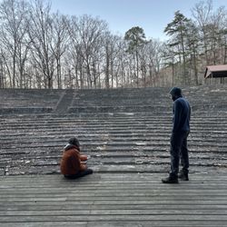
    The pinnacles are absolutely gorgeous. And at the beginning of the trail, there is a gorgeous and…read morerustic amphitheater. If you stand on the stage and look out, the backdrop is the hilly mountains. So cool and really inspiring (especially if you were a theater kid!). We went up to a Indian lookout points, such a lovely view. We started heading West, which the sign did say was a difficult descent. But when we got to the cliff you had to climb down, the trail markers weren't totally clear, plus the sun was setting, so we decided to turn around and go to the Devil's Kitchen. It's amazing how difficult these trails are! We descended to multiple cliff formations with little caves to chill under. The scenery is 10/10. I just think the trail markers could be a tiny bit clearer. Highly suggest!

    Photos
    Pinnacles Hiking Trails
    Pinnacles Hiking Trails
    Pinnacles Hiking Trails

    See all

    Dawkins Line Rail Trail - hiking - Updated July 2026
    Loading...
    Loading...
    Loading...