Ebensburg War Memorial Photos


More like Ebensburg War Memorial
Recommended Reviews - Ebensburg War Memorial
Start your review...

3 years ago


15 years ago
10 years ago
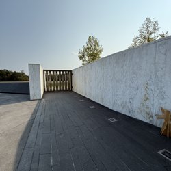
Nice small memorial to the soldiers that fought in the revolutionary war, mexican war, war of 1812, spanish american war and civil war. Plaques of all the names of soldiers that died for Pennsylvania. read more


More info about Ebensburg War Memorial


Ebensburg War Memorial - landmarks - Updated June 2026
Best of Ebensburg
People found Ebensburg War Memorial by searching for…
Things to Do in Ebensburg, Pennsylvania
Attractions in Ebensburg, Pennsylvania
Things to See in Ebensburg, Pennsylvania
Places to Take Pictures in Ebensburg, Pennsylvania
Photo Spots in Ebensburg, Pennsylvania
Scenic Overlook in Ebensburg, Pennsylvania
Tourist Attractions in Ebensburg, Pennsylvania
Hiking Trails in Ebensburg, Pennsylvania
Walking Trails in Ebensburg, Pennsylvania
Scenic Views in Ebensburg, Pennsylvania
View Points in Ebensburg, Pennsylvania
Public Services & Government in Ebensburg, Pennsylvania
Military Museum in Ebensburg, Pennsylvania
Landmarks in Ebensburg, Pennsylvania
Historical Sites in Ebensburg, Pennsylvania
Places to Visit in Ebensburg, Pennsylvania
Field Trips in Ebensburg, Pennsylvania
Observation Deck in Ebensburg, Pennsylvania
Night View in Ebensburg, Pennsylvania
Picnic Areas in Ebensburg, Pennsylvania
DMV Offices in Ebensburg, Pennsylvania
Castles in Ebensburg, Pennsylvania
Trending Searches in Ebensburg, PA
Bait And Tackle Shop near Ebensburg War Memorial
Day Trips near Ebensburg War Memorial
Dog Swimming near Ebensburg War Memorial
Fishing Spots near Ebensburg War Memorial
Hiking near Ebensburg War Memorial
Kayak Rental near Ebensburg War Memorial
Landmarks & Historical Buildings near Ebensburg War Memorial
Pick Your Own Farms near Ebensburg War Memorial
Pool Supplies near Ebensburg War Memorial
River Swimming near Ebensburg War Memorial
River Tubing near Ebensburg War Memorial
Scenic Restaurants near Ebensburg War Memorial
Splash Pad near Ebensburg War Memorial
Strawberry Picking near Ebensburg War Memorial
Swimming Holes near Ebensburg War Memorial
Swimming Lakes near Ebensburg War Memorial
Swimming Pools near Ebensburg War Memorial
Things To Do This Weekend near Ebensburg War Memorial
Browse Articles
Browse Nearby
BEST of Ebensburg, Pennsylvania Photo Spots near Ebensburg War Memorial
BEST of Ebensburg, Pennsylvania Restaurants near Ebensburg War Memorial
BEST of Ebensburg, Pennsylvania Things to Do near Ebensburg War Memorial
BEST of Ebensburg, Pennsylvania Museums near Ebensburg War Memorial
BEST of Ebensburg, Pennsylvania Coffee near Ebensburg War Memorial
BEST of Ebensburg, Pennsylvania Hotels near Ebensburg War Memorial
BEST of Ebensburg, Pennsylvania Campgrounds near Ebensburg War Memorial
BEST of Ebensburg, Pennsylvania Breakfast near Ebensburg War Memorial
BEST of Ebensburg, Pennsylvania Ski Resorts near Ebensburg War Memorial
Browse Brands
Related Searches in Ebensburg, PA
Best Fun Things to Do in Ebensburg, Pennsylvania
Book Engaging Historical Tours in Ebensburg, Pennsylvania
Discover Charming Historic Homes in Ebensburg, Pennsylvania
Discover Family-Friendly Aquariums in Ebensburg, Pennsylvania
Discover Historic Sites and Places in Ebensburg, Pennsylvania
Discover Popular Landmarks in Ebensburg, Pennsylvania
Discover Popular Photo Spots in Ebensburg, Pennsylvania
Discover the Best Beaches in Ebensburg, Pennsylvania
Enjoy Arts & Entertainment in Ebensburg, Pennsylvania
Enjoy Hiking Adventures in Ebensburg, Pennsylvania
Enjoy the Best Walking Trails in Ebensburg, Pennsylvania
Experience Stunning Sunset Views in Ebensburg, Pennsylvania
Explore Beautiful Botanical Gardens in Ebensburg, Pennsylvania
Explore Beautiful Castles and Landmarks in Ebensburg, Pennsylvania
Explore Beautiful Parks and Green Spaces in Ebensburg, Pennsylvania
Explore Children's Museums Near Ebensburg, Pennsylvania
Explore Family-Friendly Zoos and Wildlife in Ebensburg, Pennsylvania
Explore Free Things to Do Around Ebensburg, Pennsylvania
Explore Fun Activities to Do in Ebensburg, Pennsylvania
Explore Fun Field Trips in Ebensburg, Pennsylvania
Explore Popular Scenic Overlook Points in Ebensburg, Pennsylvania
Explore Popular Scenic Views Near Ebensburg, Pennsylvania
Explore Scenic Lakes to Visit in Ebensburg, Pennsylvania
Explore Secret Spots Worth Visiting in Ebensburg, Pennsylvania
Explore Top Art Galleries Located in Ebensburg, Pennsylvania
Explore Venues & Event Spaces in Ebensburg, Pennsylvania
Explore Vibrant Public Art Displays in Ebensburg, Pennsylvania
Find Beautiful Views in Ebensburg, Pennsylvania
Find Exciting Tours to Take in Ebensburg, Pennsylvania
Find Fun Things to Do With Kids in Ebensburg, Pennsylvania
Find Top Art Museums in Ebensburg, Pennsylvania
Find Top Libraries to Visit in Ebensburg, Pennsylvania
Find Top-Rated Waterfalls in Ebensburg, Pennsylvania Now
Find the Best Bridge Spots in Ebensburg, Pennsylvania
Find the Best Playgrounds to Visit in Ebensburg, Pennsylvania
Fun Rainy Day Activities to Try in Ebensburg, Pennsylvania
Hiking Trails With Waterfalls in Ebensburg, Pennsylvania
Must-See Tourist Attractions Around Ebensburg, Pennsylvania
Popular Kids Activities in Ebensburg, Pennsylvania
Popular Picnic Spots to Visit in Ebensburg, Pennsylvania
Popular Places to Take Pictures in Ebensburg, Pennsylvania
Popular Things to Do in Ebensburg, Pennsylvania
Stair Climbing Activities and Gyms in Ebensburg, Pennsylvania
Top Hiking Trails to Explore in Ebensburg, Pennsylvania
Top Historic Restaurants to Try in Ebensburg, Pennsylvania
Top Things to Do With Kids in Ebensburg, Pennsylvania
Tour Famous Lighthouses Located in Ebensburg, Pennsylvania
Visit Cultural Centers in Ebensburg, Pennsylvania
People who viewed Ebensburg War Memorial also viewed
Sgt Michael Strank Memorial Park
2 reviews
Cambria County Library System
1 review
Staple Bend Tunnel
1 review
Lemon House
2 reviews
Stone Bridge
1 review
US Post Office
1 review
Cresson Sanatorium & Prison
1 review
Young Peoples Community Center
1 review
Department of Motor Vehicles
1 review
Pennsylvania Commonwealth of
4 reviews