Johnstown Flood National Memorial Photos


More like Johnstown Flood National Memorial
Recommended Reviews - Johnstown Flood National Memorial
Start your review...


Reviews With Photos


I was not very familiar with the Johnstown Flood, clearly demonstrating the importance of having memorial like this. The site is well maintained and includes a museum with some exhibits and displays about the flood, a film, and some historic buildings. They are situated above the site of the former dam and its affiliated lake, which is now covered in plant life and trees and has a trail that can be enjoyed. The rangers were very friendly and gave us a rundown after welcoming us into the visitor center. They offer a Junior Ranger program for the site, as well. You can also drive around to the other side of the dam, where there are trailheads, a restroom facility and a small parking lot.


This is a subject I teach in school each year, so I was very eager to see the area. There's not much to the museum, but the movie you see there is well done. There are placards to read and a recording of a survivor telling his story. There are outside things to see, but the wind was biting that day. I'm glad we took the time to see this place.


You know what irks me? When someone gives you a history lesson instead of a review. Also, when someone does nothing but complain about the place they are reviewing. Can I just say, 'Quit your bitching.' Can I get an Amen? Johnstown Flood National Memorial is not hard to find as one previous reviewer wrote. Take the main highway (US 219) to the exit and within a few minutes you are there. People need to take it easy with the negativity here. Don't you think there is already enough negativity here? I mean the flood did start here and mismanagement of the club was here. Are you expecting some grand extravagant theme park? It's a humble place, comprised of buildings that probably sat dormant for years because of the stigma that place held. You really should just be there to take in the shear size of the place. You don't need any sign to tell you where the dam began, it's pretty obvious (you can even see it from the highway). Then all you have to do after that is look back from that point and see where the water stretched to. What most people don't tell you here is that you can walk down to the dam breast and go out to the observation decks. Here, you get a better perspective as to where the water laid and how far back it went. There are signs with information dotting the place for the people that may not know what happened here years ago. Inside is a nice mix of informative displays and visual cues to show you how bad the flood was. Staff, at least when I was here, were pleasant and informative. They even suggested that after we were done here that we go down into Johnstown for the flood museum (they even knew the hours of that place even though they aren't under the same company). How about that...an actual review on a place with minimal (if any) history lesson. And I don't think I complained once about the place. How refreshing.


Sadly, I had very little knowledge of Johnstown. I think this may be embarrassing to people living in that region, but common to those of us that do not. Regardless, national sites like this allow all of us to learn more about our country. This was certainly a site of darker times. On May 31, 1889, after relentless rain, 20,000,000 tons of water gobbled up Johnstown, Pennsylvania killing over 2,000 unsuspecting victims. Despite enjoying this chance to learn more (and I did!), I was disappointed with this site in comparison to others I have visited. The movie was informative, but way too long and dark. The visitor center museum felt very amateurish. I didn't feel like there was enough to see and do here. If you'd like, you can drive further to visit the cemetery.


I stop by regularly to think. I watch the runners on the quiet paths. I look over the vista of the lake bed and acknowledge the beauty of the area that turned it into a vacation oasis onehundredthirtyfive years ago. Emotions wash over me during meditation reflections as I sit there.


1 year ago

2 years ago
There is not much to see here but you'll learn a lot about the tragedy. The rangers here are very friendly and knowledgeable. Plenty of parking space. read more


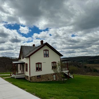

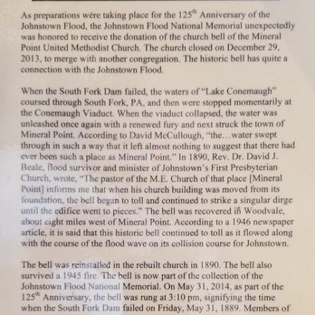
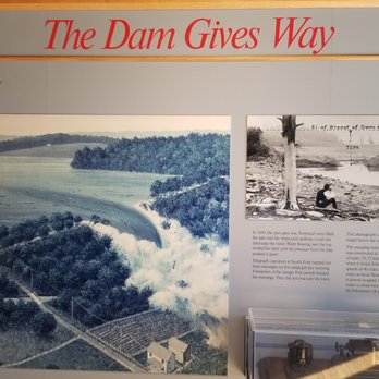
The Johnstown Flood National Memorial Visitor Center sits on the hillside just above the historic dam site and provides a good view up the South Fork of the Little Conemaugh River and the valley that once held Lake Conemaugh. Across the valley, you can still see the South Fork Fishing and Hunting Club, once a private resort for rich folks from Pittsburgh perched on what was the historic edge of the lake. The rich and famous, including Andrew W. Mellon and Henry Clay Frick, were some of the members. The 1889 clubhouse is now part of the memorial. The Club had purchased the land around the lake including the old leak-prone dam and had done little to maintain it. The Johnstown Flood National Memorial was established in 1964, commemorates the Great Johnstown Flood of May 31, 1889, and preserves the remains of the South Fork Dam. On May 31, 1889, after torrential rains, the dam burst sending a 40-foot wall of water into the city of Johnstown, Pennsylvania. More than 2,000 people were killed with a third never identified, including 99 whole families and 400 children under the age of 10. Hundreds of homes and businesses were destroyed. The National Park Service did a wonderful job pulling together the National Memorial to help explain the tragic story. There are a lot of photographs to be seen. There is a 35-minute film called "Black Friday," which does an excellent job of recreating the Great Flood. Other exhibits explain the causes and the effects of the flood. Afterward, you should take the time to visit the Grandview Cemetery, where many of the 2,200 are buried. read more




4 years ago
I was not very familiar with the Johnstown Flood, clearly demonstrating the importance of having memorial like this. The site is well maintained and includes a museum with some exhibits and displays about the flood, a film, and some historic buildings. They are situated above the site of the former dam and its affiliated lake, which is now covered in plant life and trees and has a trail that can be enjoyed. The rangers were very friendly and gave us a rundown after welcoming us into the visitor center. They offer a Junior Ranger program for the site, as well. You can also drive around to the other side of the dam, where there are trailheads, a restroom facility and a small parking lot. read more


This is a subject I teach in school each year, so I was very eager to see the area. There's not much to the museum, but the movie you see there is well done. There are placards to read and a recording of a survivor telling his story. There are outside things to see, but the wind was biting that day. I'm glad we took the time to see this place. read more


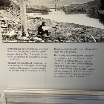

5 years ago

13 years ago
You know what irks me? When someone gives you a history lesson instead of a review. Also, when someone does nothing but complain about the place they are reviewing. Can I just say, 'Quit your bitching.' Can I get an Amen? Johnstown Flood National Memorial is not hard to find as one previous reviewer wrote. Take the main highway (US 219) to the exit and within a few minutes you are there. People need to take it easy with the negativity here. Don't you think there is already enough negativity here? I mean the flood did start here and mismanagement of the club was here. Are you expecting some grand extravagant theme park? It's a humble place, comprised of buildings that probably sat dormant for years because of the stigma that place held. You really should just be there to take in the shear size of the place. You don't need any sign to tell you where the dam began, it's pretty obvious (you can even see it from the highway). Then all you have to do after that is look back from that point and see where the water stretched to. What most people don't tell you here is that you can walk down to the dam breast and go out to the observation decks. Here, you get a better perspective as to where the water laid and how far back it went. There are signs with information dotting the place for the people that may not know what happened here years ago. Inside is a nice mix of informative displays and visual cues to show you how bad the flood was. Staff, at least when I was here, were pleasant and informative. They even suggested that after we were done here that we go down into Johnstown for the flood museum (they even knew the hours of that place even though they aren't under the same company). How about that...an actual review on a place with minimal (if any) history lesson. And I don't think I complained once about the place. How refreshing. read more


8 years ago
Sadly, I had very little knowledge of Johnstown. I think this may be embarrassing to people living in that region, but common to those of us that do not. Regardless, national sites like this allow all of us to learn more about our country. This was certainly a site of darker times. On May 31, 1889, after relentless rain, 20,000,000 tons of water gobbled up Johnstown, Pennsylvania killing over 2,000 unsuspecting victims. Despite enjoying this chance to learn more (and I did!), I was disappointed with this site in comparison to others I have visited. The movie was informative, but way too long and dark. The visitor center museum felt very amateurish. I didn't feel like there was enough to see and do here. If you'd like, you can drive further to visit the cemetery. read more


5 years ago
I stop by regularly to think. I watch the runners on the quiet paths. I look over the vista of the lake bed and acknowledge the beauty of the area that turned it into a vacation oasis onehundredthirtyfive years ago. Emotions wash over me during meditation reflections as I sit there. read more


4 years ago
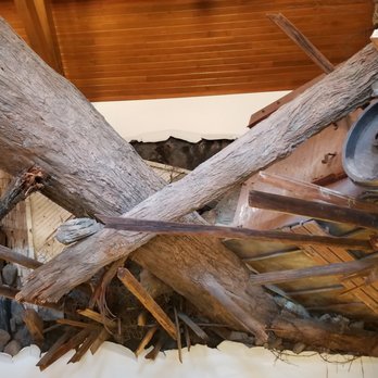
We were traveling this weekend and passed a sign for the National Park. We decided to swing around and stop by. So glad that we did! It was very interesting to learn about the flood. The life-like tree in the house was amazing to see. The rangers were very helpful and informative. We definitely recommend you watch the on-site movie that truly takes you back to events of that fateful day. The theater is extremely nice for this site. If you enjoy national parks you won't be disappointed. read more


4 years ago
3 years ago


13 years ago
4 years ago


15 years ago

10 years ago

13 years ago

14 years ago

13 years ago

12 years ago

9 years ago

12 years ago

11 years ago
14 years ago
16 years ago
13 years ago
More info about Johnstown Flood National Memorial
Ask the Community - Johnstown Flood National Memorial
Review Highlights - Johnstown Flood National Memorial




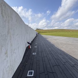
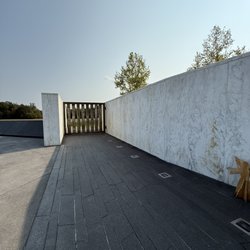









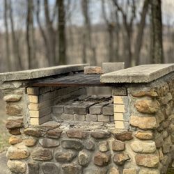


Johnstown Flood National Memorial - landmarks - Updated September 2026
Best of South Fork
People found Johnstown Flood National Memorial by searching for…
Places to Take Pictures in South Fork, PA
Free Things to Do in South Fork, PA
Scenic Views in South Fork, PA
Scenic Overlook in South Fork, PA
Beautiful Views in South Fork, PA
Scenic Drive in South Fork, PA
Observation Deck in South Fork, PA
Fun Things to Do at Night in South Fork, PA
Watch Sunset in South Fork, PA
Walking Trails in South Fork, PA
Tourist Attractions in South Fork, PA
Arts & Entertainment in South Fork, PA
Historical Tours in South Fork, PA
Trending Searches in South Fork, PA
Apple Picking near Johnstown Flood National Memorial
Archery near Johnstown Flood National Memorial
Attraction Farms near Johnstown Flood National Memorial
Beautiful Views near Johnstown Flood National Memorial
Catholic Schools near Johnstown Flood National Memorial
Consignment Shops near Johnstown Flood National Memorial
Dance Wear near Johnstown Flood National Memorial
Eyelash Extensions near Johnstown Flood National Memorial
Formal Wear near Johnstown Flood National Memorial
Kids Birthday Party near Johnstown Flood National Memorial
Landmarks & Historical Buildings near Johnstown Flood National Memorial
Makeup Artists near Johnstown Flood National Memorial
Mens Suits near Johnstown Flood National Memorial
Photo Spots near Johnstown Flood National Memorial
Places To Take Pictures near Johnstown Flood National Memorial
Private Schools near Johnstown Flood National Memorial
Pumpkin Patches near Johnstown Flood National Memorial
Scenic Overlook near Johnstown Flood National Memorial
Things To Do This Weekend near Johnstown Flood National Memorial
Browse Articles
Browse Nearby
BEST of South Fork, Pennsylvania Restaurants near Johnstown Flood National Memorial
BEST of South Fork, Pennsylvania Parks near Johnstown Flood National Memorial
BEST of South Fork, Pennsylvania Things to Do near Johnstown Flood National Memorial
BEST of South Fork, Pennsylvania Coffee near Johnstown Flood National Memorial
BEST of South Fork, Pennsylvania Breakfast near Johnstown Flood National Memorial
BEST of South Fork, Pennsylvania Attractions near Johnstown Flood National Memorial
BEST of South Fork, Pennsylvania Hotels near Johnstown Flood National Memorial
Browse Brands
Related Searches in South Fork, PA
Beautiful Flower Fields in South Fork, Pennsylvania
Best Fun Things to Do in South Fork, Pennsylvania
Book Engaging Historical Tours in South Fork, Pennsylvania
Discover Charming Historic Homes in South Fork, Pennsylvania
Discover Famous Monuments in South Fork, Pennsylvania
Discover Fun Things to Do Alone in South Fork, Pennsylvania
Discover Historic Sites and Places in South Fork, Pennsylvania
Discover Popular Landmarks in South Fork, Pennsylvania
Discover Popular Photo Spots in South Fork, Pennsylvania
Discover the Best Beaches in South Fork, Pennsylvania
Discover the Best Night Hike Trails in South Fork, Pennsylvania
Enjoy Hiking Adventures in South Fork, Pennsylvania
Enjoy the Best Night View Spots in South Fork, Pennsylvania
Enjoy the Best Walking Trails in South Fork, Pennsylvania
Experience Stunning Sunset Views in South Fork, Pennsylvania
Explore Beautiful Botanical Gardens in South Fork, Pennsylvania
Explore Beautiful Castles and Landmarks in South Fork, Pennsylvania
Explore Beautiful Parks and Green Spaces in South Fork, Pennsylvania
Explore Children's Museums Near South Fork, Pennsylvania
Explore Family-Friendly Zoos and Wildlife in South Fork, Pennsylvania
Explore Free Things to Do Around South Fork, Pennsylvania
Explore Fun Field Trips in South Fork, Pennsylvania
Explore Popular Scenic Overlook Points in South Fork, Pennsylvania
Explore Popular Scenic Views Near South Fork, Pennsylvania
Explore Scenic Lakes to Visit in South Fork, Pennsylvania
Explore Secret Spots Worth Visiting in South Fork, Pennsylvania
Explore Top Art Galleries Located in South Fork, Pennsylvania
Explore Venues & Event Spaces in South Fork, Pennsylvania
Find Beautiful Views in South Fork, Pennsylvania
Find Fun Things to Do With Kids in South Fork, Pennsylvania
Find Fun Things to Do at Night With Kids in South Fork, Pennsylvania
Find Top Art Museums in South Fork, Pennsylvania
Find Top-Rated Waterfalls in South Fork, Pennsylvania Now
Find the Best Bridge Spots in South Fork, Pennsylvania
Find the Best Parks for Picnics in South Fork, Pennsylvania
Fun Rainy Day Activities to Try in South Fork, Pennsylvania
Hiking Trails With Waterfalls in South Fork, Pennsylvania
Must-See Tourist Attractions Around South Fork, Pennsylvania
Plan a Scenic Drive Route Near South Fork, Pennsylvania
Popular Kids Activities in South Fork, Pennsylvania
Popular Outdoor Activities to Try in South Fork, Pennsylvania
Popular Places to Take Pictures in South Fork, Pennsylvania
Popular Things to Do in South Fork, Pennsylvania
Popular Things to See in South Fork, Pennsylvania
Secure Convenient Parking Options in South Fork, Pennsylvania
Top Hiking Trails to Explore in South Fork, Pennsylvania
Tour Famous Lighthouses Located in South Fork, Pennsylvania


