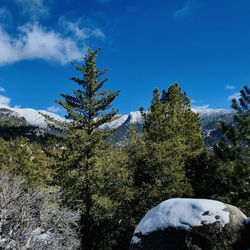
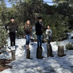
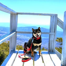
Ernie Maxwell Scenic Trail Photos


You might also consider
More like Ernie Maxwell Scenic Trail
Recommended Reviews - Ernie Maxwell Scenic Trail
Start your review...

Reviews With Photos


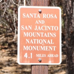
Easy and nice, We were able to use our America the beautiful pass that Rdawg has. You did need a special permit to go up to hike devils slide hike, the ranger stopped us to let us know and was turning people back to get one. We walked down to the entrance for Ernie maxwell scenic trail. It was an easy trail and glad we started around 8 am any later it would have been too hot. We had enough shade and were able to hike without getting wet. We passed a couple streams with flowing water.


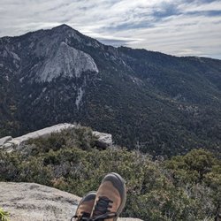
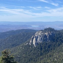
This is a very nice hike. Parking is rough, though. You park along the side of the mountain and hopefully, leave enough space for cars to still pass by. At the time of our visit, no Adventure Pass was required for parking but please do your own homework and don't send me your parking ticket. We didn't complete the full hike but I understand it's an out and back, 2.3 miles each way. The elevation gain is very gradual throughout and I would definitely classify this as an easy hike. There's plenty of shade, too, which is very nice. There are also very nice views throughout the hike and plenty of places to rest (just on rocks and such, no benches or anything like that). It wasn't too buggy during our visit and there were plenty of birds and squirrels to enjoy. Well worth a visit.

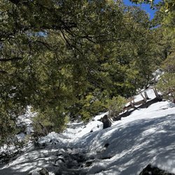
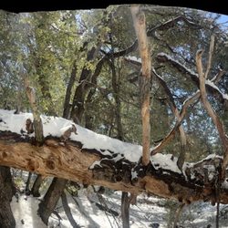
This was a ~4.6 mile round trip that took ~2.5 hours to complete. Trail was easy to follow; microspikes were helpful. There were 3 or 4 small stream crossings; all do-able without getting wet. Furthermore, there were 3 areas with downed trees on the trail. This was a peaceful and enjoyable hike. Unfortunately, the end of the trail was anticlimactic as it ends at a road without any exceptional view. Parking was limited since there are many popular trails in the same area. Short video of the hike for those interested! https://youtu.be/R9bkBHtQfQY

Easy trail to get to and to walk on. Very family friendly. Gets hot in the summer and during midday. Parking is easy. Make sure you get adventure pass about few miles away in town , at ranger station or the gas station around the ranger station. Overall enjoyed the hike. Good scenery and best of all lots of shades. Would definitely recommend for anyone seeking an easy and leisurely trail walk.

A great hike with great scenery, definitely not difficult at all. Plenty of areas of shade even at high noon! Very small stream crossings but tons of wild life. Be cautious of rattle snakes! Encountered one on my last visit. Also the area can have poison oak, so keep an eye out for that.. especially by water and at the base of trees. Mountain lions are also possible but more likely to be spotted at dusk and dawn (DO NOT RUN, make yourself big & loud, do not turn your back) Please take care of the trail(: pack out what you packed in


Although it's an easy trail, I'd like to warn those who are afraid of height to prepare for some areas that are steep. This trail can be seen on your right side, immediately after turning right by the Humber park sign. Do not go all the way up as it will lead you to the San Jacinto Wilderness Park. Unless, of course, if you want to take that trail too. .


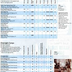
Idyllwild is a great place to hike and has some of the funnest trails in the area. The Ernie Maxwell Scenic Trail might be the most used out of all of them. In order to hike this trail from Humber Park you'll need to purchase an Adventure parking pass at the ranger station in town ( $5 for the day or $30 for a year). However, unlike the other trailheads that originate from Humber Park, you DO NOT need the Wilderness pass. The Wilderness passes are distributed on a first come / first served basis at the Ranger station downtown Idyllwild and they DO run out during the summer weekends! The Ernie Maxwell Scenic Trail is really popular because it's relatively easy and good for newbies, families, and senior citizens. It's about 4.5 miles there and back, but don't underestimate it's lack of huge elevation jumps as it not being able to kick your butt. You are at some elevation and it might be very hot/cold depending on the weather. Bring way more water than you think will be required ( and bring some food like apples / bars). PROS - No Wilderness Pass required ( Remember, you still need to buy an Adventure parking pass) - The whole family (all ages) can hike this trail. Dogs too.. CONS - It's popular and at times it's hard to feel like you're outdoors on busy days. - There and back can be a bit boring on this trail because it all looks mostly the same. - A lot of dogs unleashed, but not were scary. And no POOP on the trail ( Which is a pro)

I am not going to fool anyone! If you are just beginning to wake up your muscles and you are just blubber like me. This is your beginners trail. It is really and easy one and super shady. Really pretty and peaceful especially if are alone. Trust me this is a piece of cake hike. the only thing you need to maybe worry is the thin air. That is the only thing that really slows me down. I have been coming out and about to this trail for about seven years. I have never seen a bear or mountain Lions. Only people and dogs. No bathrooms only at Humber Park. So yes pack TP and H20.

This was a nice and easy hike around 5 miles round trip. It's pretty much out and back. Theres a good amount of parking near the trail. The parking can get busy since there's other trails nearby. Where we started, there was a creek right in the beginning. There's a distinct trail to follow and the terrain isn't too bad. Theres some rocks here and there. The views were amazing as we were able to see different types of trees, mountain, birds, and squirrels. It got a little repetitive towards the end because it looked like we were passing by the same thing over and over. read more


This is such a perfect hiking trail!!! It's called the scenic route but I think the distance and slow incline are a perfect workout for those of us that don't go hiking too often. It's a very beautiful trail with a couple creeks and lot of people with their dogs. Would definitely hike this trail again just for a calming walk with nice views. read more


1 year ago
very easy, meh hike. You can park along the road & do the uphill portion first (I recommend doing it this way) Or you can park in a parking lot and do the uphill on the way back to your vehicle. It's an out and back trail. About 2.5 miles each way from trailhead to trailhead - takes around 2 to 3 hours. Path is kept clear - we saw lots of families and dogs on this trail. It just didn't have spectacular views in my opinion, making it a mehhhh hike. read more


7 months ago
Moderate hike, half shaded, with some pretty nice Yosemite-esque views! I enjoyed some fall foliage in mid-November. Nothing mind blowing, more like a nice walk with some incline to get your cardio in. Dogs allowed on leash and limited parking available at trail head. read more


Easy and nice, We were able to use our America the beautiful pass that Rdawg has. You did need a special permit to go up to hike devils slide hike, the ranger stopped us to let us know and was turning people back to get one. We walked down to the entrance for Ernie maxwell scenic trail. It was an easy trail and glad we started around 8 am any later it would have been too hot. We had enough shade and were able to hike without getting wet. We passed a couple streams with flowing water. read more


2 months ago
11 months ago
A great hike, I recommend starting at the bottom of the hill so that your walk back is easier! read more


1 year ago
This is a very nice hike. Parking is rough, though. You park along the side of the mountain and hopefully, leave enough space for cars to still pass by. At the time of our visit, no Adventure Pass was required for parking but please do your own homework and don't send me your parking ticket. We didn't complete the full hike but I understand it's an out and back, 2.3 miles each way. The elevation gain is very gradual throughout and I would definitely classify this as an easy hike. There's plenty of shade, too, which is very nice. There are also very nice views throughout the hike and plenty of places to rest (just on rocks and such, no benches or anything like that). It wasn't too buggy during our visit and there were plenty of birds and squirrels to enjoy. Well worth a visit. read more


This was a ~4.6 mile round trip that took ~2.5 hours to complete. Trail was easy to follow; microspikes were helpful. There were 3 or 4 small stream crossings; all do-able without getting wet. Furthermore, there were 3 areas with downed trees on the trail. This was a peaceful and enjoyable hike. Unfortunately, the end of the trail was anticlimactic as it ends at a road without any exceptional view. Parking was limited since there are many popular trails in the same area. Short video of the hike for those interested! https://youtu.be/R9bkBHtQfQY read more


Easy trail to get to and to walk on. Very family friendly. Gets hot in the summer and during midday. Parking is easy. Make sure you get adventure pass about few miles away in town , at ranger station or the gas station around the ranger station. Overall enjoyed the hike. Good scenery and best of all lots of shades. Would definitely recommend for anyone seeking an easy and leisurely trail walk. read more


2 years ago
A great hike with great scenery, definitely not difficult at all. Plenty of areas of shade even at high noon! Very small stream crossings but tons of wild life. Be cautious of rattle snakes! Encountered one on my last visit. Also the area can have poison oak, so keep an eye out for that.. especially by water and at the base of trees. Mountain lions are also possible but more likely to be spotted at dusk and dawn (DO NOT RUN, make yourself big & loud, do not turn your back) Please take care of the trail(: pack out what you packed in read more


5 years ago
Although it's an easy trail, I'd like to warn those who are afraid of height to prepare for some areas that are steep. This trail can be seen on your right side, immediately after turning right by the Humber park sign. Do not go all the way up as it will lead you to the San Jacinto Wilderness Park. Unless, of course, if you want to take that trail too. . read more


3 years ago
Beautiful and easy trail! We started from the southern entrance because it is free parking and you start uphill, then when your tired you can go downhill . read more


Idyllwild is a great place to hike and has some of the funnest trails in the area. The Ernie Maxwell Scenic Trail might be the most used out of all of them. In order to hike this trail from Humber Park you'll need to purchase an Adventure parking pass at the ranger station in town ( $5 for the day or $30 for a year). However, unlike the other trailheads that originate from Humber Park, you DO NOT need the Wilderness pass. The Wilderness passes are distributed on a first come / first served basis at the Ranger station downtown Idyllwild and they DO run out during the summer weekends! The Ernie Maxwell Scenic Trail is really popular because it's relatively easy and good for newbies, families, and senior citizens. It's about 4.5 miles there and back, but don't underestimate it's lack of huge elevation jumps as it not being able to kick your butt. You are at some elevation and it might be very hot/cold depending on the weather. Bring way more water than you think will be required ( and bring some food like apples / bars). PROS - No Wilderness Pass required ( Remember, you still need to buy an Adventure parking pass) - The whole family (all ages) can hike this trail. Dogs too.. CONS - It's popular and at times it's hard to feel like you're outdoors on busy days. - There and back can be a bit boring on this trail because it all looks mostly the same. - A lot of dogs unleashed, but not were scary. And no POOP on the trail ( Which is a pro) read more


I am not going to fool anyone! If you are just beginning to wake up your muscles and you are just blubber like me. This is your beginners trail. It is really and easy one and super shady. Really pretty and peaceful especially if are alone. Trust me this is a piece of cake hike. the only thing you need to maybe worry is the thin air. That is the only thing that really slows me down. I have been coming out and about to this trail for about seven years. I have never seen a bear or mountain Lions. Only people and dogs. No bathrooms only at Humber Park. So yes pack TP and H20. read more


5 years ago
This is a fun and scenic trail. It's not a loop trail. The path is well defined. It took us about two hours. read more

6 years ago
The terrain is easy to moderate hike. Very appropriate for beginners. If you enjoy nature, this trail is a treat. Full of beautiful things to enjoy. Flowers in different colors: pink (Manzanilla), red, yellow, purple and orange. There were at least 5 different running creeks (big and small). Very peaceful and pretty. This trail, to me, offers a lot for a short hike of 2.6 miles round-trip. It is well worth the hike. Bring water and snacks to enjoy along the way. Happy trails! read more


6 years ago
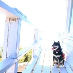
Absolutely LOVED this trail!! Very scenic and lots of shade. We took our time and enjoyed every moment. We had our Golden retriever with us too. She had plenty of rest stops along the way. Highly recommend!! read more


6 years ago
Definitely go early on the weekends and also because once that sun hits it'll get toasty. Great trail for beginners, just don't underestimate the return trip. Im in fair shape, and still made it through. Ah-mazing picture opportunities for scenery and fashion shots. read more


7 years ago
7 years ago
9 years ago
Very bful. Easy. Great for kids. Had fun hiking this trail with kids and friends. If looking for easy trail with kids then you must go with this one. Good views. read more


5 years ago
More info about Ernie Maxwell Scenic Trail
Idyllwild-Pine Cove, CA 92549
Directions
Hours
Outdoor Amenities
Ask the Community - Ernie Maxwell Scenic Trail
Review Highlights - Ernie Maxwell Scenic Trail
You might also consider


Why does Yelp recommend reviews?
2 reviews that are not currently recommended
The reviews below are not factored into the business's overall star rating.
1 year ago
9 years ago
Ernie Maxwell Scenic Trail - hiking - Updated July 2026
Best of Idyllwild-Pine Cove
People found Ernie Maxwell Scenic Trail by searching for…
Hiking Trails With Waterfalls in Idyllwild-Pine Cove, California
Things to Do in Idyllwild-Pine Cove, California
Dog Friendly Hiking Trails in Idyllwild-Pine Cove, California
Parks in Idyllwild-Pine Cove, California
Scenic Drive in Idyllwild-Pine Cove, California
Scenic View in Idyllwild-Pine Cove, California
Walking Trails in Idyllwild-Pine Cove, California
Hiking With Kids in Idyllwild-Pine Cove, California
Playgrounds in Idyllwild-Pine Cove, California
Waterfalls and Swimming Holes in Idyllwild-Pine Cove, California
Sunrise View in Idyllwild-Pine Cove, California
Running Trails in Idyllwild-Pine Cove, California
Free Parking in Idyllwild-Pine Cove, California
Things to Do at Night in Idyllwild-Pine Cove, California
Natural Hot Springs in Idyllwild-Pine Cove, California
Trails in Idyllwild-Pine Cove, California
Stroller Friendly Hikes in Idyllwild-Pine Cove, California
Photo Spots in Idyllwild-Pine Cove, California
Hikes With Dogs in Idyllwild-Pine Cove, California
Scenic Overlook in Idyllwild-Pine Cove, California
Kids in Idyllwild-Pine Cove, California
Easy Hikes in Idyllwild-Pine Cove, California
Trending Searches in Idyllwild-Pine Cove, CA
4th Of July Fireworks in Idyllwild-Pine Cove, CA
Black Owned Nail Salons in Idyllwild-Pine Cove, CA
Boat Rental in Idyllwild-Pine Cove, CA
Cliff Jumping in Idyllwild-Pine Cove, CA
Day Trips in Idyllwild-Pine Cove, CA
Fireworks in Idyllwild-Pine Cove, CA
Jet Ski Rental in Idyllwild-Pine Cove, CA
Kayak Rental in Idyllwild-Pine Cove, CA
Lakes & Ponds in Idyllwild-Pine Cove, CA
Off Road Trails in Idyllwild-Pine Cove, CA
Outdoor Activities in Idyllwild-Pine Cove, CA
Places To Walk Around in Idyllwild-Pine Cove, CA
Public Pools in Idyllwild-Pine Cove, CA
Public Shower in Idyllwild-Pine Cove, CA
River Swimming in Idyllwild-Pine Cove, CA
Rock Quarry in Idyllwild-Pine Cove, CA
Running Trails in Idyllwild-Pine Cove, CA
Scenic Night View in Idyllwild-Pine Cove, CA
Scenic Overlook in Idyllwild-Pine Cove, CA
Secluded Spots in Idyllwild-Pine Cove, CA
Soccer Store in Idyllwild-Pine Cove, CA
Splash Pad in Idyllwild-Pine Cove, CA
Strawberry Picking in Idyllwild-Pine Cove, CA
Sunrise View in Idyllwild-Pine Cove, CA
Swimming Holes in Idyllwild-Pine Cove, CA
Swimming Lakes in Idyllwild-Pine Cove, CA
Watch Sunset in Idyllwild-Pine Cove, CA
Browse Articles
Browse Nearby
BEST of Idyllwild-Pine Cove, California Coffee near Ernie Maxwell Scenic Trail
BEST of Idyllwild-Pine Cove, California Restaurants near Ernie Maxwell Scenic Trail
BEST of Idyllwild-Pine Cove, California Things to Do near Ernie Maxwell Scenic Trail
BEST of Idyllwild-Pine Cove, California Parks near Ernie Maxwell Scenic Trail
BEST of Idyllwild-Pine Cove, California Scenic View near Ernie Maxwell Scenic Trail
BEST of Idyllwild-Pine Cove, California Breakfast near Ernie Maxwell Scenic Trail
BEST of Idyllwild-Pine Cove, California Campgrounds near Ernie Maxwell Scenic Trail
BEST of Idyllwild-Pine Cove, California Sledding near Ernie Maxwell Scenic Trail
BEST of Idyllwild-Pine Cove, California Snow Tubing near Ernie Maxwell Scenic Trail
Browse Brands
Related Searches in Idyllwild-Pine Cove, CA
Best Fishing Locations and Guides in Idyllwild-Pine Cove, California
Best Places for Horseback Riding in Idyllwild-Pine Cove, California
Best Sledding Spots and Fun in Idyllwild-Pine Cove, California
Best Waterfalls and Swimming Holes in Idyllwild-Pine Cove, California
Check Out Off Road Trails in Idyllwild-Pine Cove, California
Discover Dog Friendly Trails to Explore in Idyllwild-Pine Cove, California
Discover Scenic Mountain Bike Trails Near Idyllwild-Pine Cove, California
Discover Walking Parks in Idyllwild-Pine Cove, California Near You
Discover a Hiking Trail in Idyllwild-Pine Cove, California
Discover the Best Night Hike Trails in Idyllwild-Pine Cove, California
Discover the Best Running Track in Idyllwild-Pine Cove, California
Dog-Friendly Hikes With Dogs in Idyllwild-Pine Cove, California
Enjoy Camping Adventures Around Idyllwild-Pine Cove, California
Enjoy Exciting Mountain Biking Adventures in Idyllwild-Pine Cove, California
Enjoy Kayaking Adventures in Idyllwild-Pine Cove, California
Enjoy Tent Camping Spots Around Idyllwild-Pine Cove, California
Enjoy a Beautiful Waterfall Hike in Idyllwild-Pine Cove, California
Enjoy the Best Walking Trails in Idyllwild-Pine Cove, California
Exciting Cliff Jumping Spots in Idyllwild-Pine Cove, California
Explore Beautiful Parks and Green Spaces in Idyllwild-Pine Cove, California
Explore Easy Hikes Perfect for All in Idyllwild-Pine Cove, California
Explore Fun Activities to Do in Idyllwild-Pine Cove, California
Explore Popular Campgrounds Near Idyllwild-Pine Cove, California
Explore Top Dog Parks in Idyllwild-Pine Cove, California Near You
Explore the Best Boating Spots in Idyllwild-Pine Cove, California
Explore the Best Swimming Holes Around Idyllwild-Pine Cove, California
Explore the Best Trail Options in Idyllwild-Pine Cove, California
Family Friendly Hiking With Kids in Idyllwild-Pine Cove, California
Find Beautiful Views in Idyllwild-Pine Cove, California
Find Popular Ziplining Spots Around Idyllwild-Pine Cove, California
Find the Best Parks for Picnics in Idyllwild-Pine Cove, California
Find the Best Playgrounds to Visit in Idyllwild-Pine Cove, California
Find the Best Scenic View Locations in Idyllwild-Pine Cove, California
Great Places to Walk in Idyllwild-Pine Cove, California
Hike the Popular Waterfall Trail in Idyllwild-Pine Cove, California
Hiking Trails With Waterfalls in Idyllwild-Pine Cove, California
Plan Nature Center Visits in Idyllwild-Pine Cove, California
Plan a Scenic Drive Route Near Idyllwild-Pine Cove, California
Popular Fishing Spots to Explore in Idyllwild-Pine Cove, California
Popular Picnic Spots to Visit in Idyllwild-Pine Cove, California
Popular Things to Do in Idyllwild-Pine Cove, California
Popular Things to See in Idyllwild-Pine Cove, California
Safe River Swimming Areas in Idyllwild-Pine Cove, California
Safe and Fun Parks for Kids in Idyllwild-Pine Cove, California
Top Climbing Spots and Gyms in Idyllwild-Pine Cove, California
Top Playgrounds for Kids to Enjoy in Idyllwild-Pine Cove, California
Top Running Trails to Explore in Idyllwild-Pine Cove, California
Top Swimming Lakes to Enjoy in Idyllwild-Pine Cove, California
Top Swimming Spots and Pools in Idyllwild-Pine Cove, California
Walk Dog Friendly Hiking Trails in Idyllwild-Pine Cove, California
People who viewed Ernie Maxwell Scenic Trail also viewed
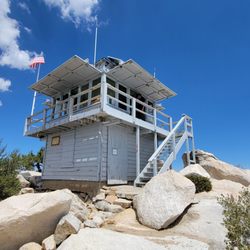
Tahquitz Peak via Devil's Slide Trail
22 reviews
Deer Springs Trail To Suicide Rock
27 reviews
San Jacinto Ranger Station
18 reviews
The Wildlands Conservancy - Mission Creek Preserve
8 reviews
Fern Basin Campground
22 reviews
Massacre Canyon
8 reviews
San Gorgonio via Vivian Creek
54 reviews
Lykken Trail
46 reviews
Whitewater Riverbed
7 reviews
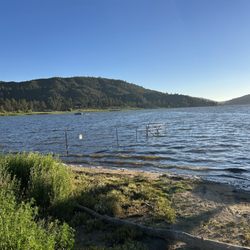
Lake Hemet
1117 reviews