Estero Island Photos


More like Estero Island
Recommended Reviews - Estero Island
Start your review...

12 years ago
The beach is lovely-- clean white sand and all the ocean you could want. There are so many things to do-- paddle board, boat, kayak, jet ski, swim, lay around, shell hunt (esp. at Lover's Key), bird watch... The beach is cleaned constantly and combed daily so there is virtually no trash. At low tide, you can find all kinds of critters on the beach-- we threw back many a starfish, brittle start, and sea cucumber. Please do not dig up live sand dollars or bother the live crabs! Many interesting artifacts to be found at any time-- horseshoe crab corpses, sea pork, seaweeds, etc. Many birds-- different types of sandpipers and gulls, egrets, pelicans-- some are playful or unafraid of close contact with humans. Loved the beach! Hated the island. The traffic is god awful south of San Carlos and north there is nothing but bars and curio stands. Old people or young people everywhere, not much for the middle-aged. The food offerings are terrible-- only pizza, burgers, ice cream-- certainly nothing veg-friendly or healthy to be found. In town, Ft. Myers is not much better. Probably will not go back, but if I do, I will be sure to stock up on some healthy food in Tampa or Naples to stock my fridge so I can enjoy beach time instead of having to drive off the island every night for something decent to eat. read more


More info about Estero Island


Estero Island - landmarks - Updated July 2026
Best of Fort Myers Beach
People found Estero Island by searching for…
Things to Do in Fort Myers Beach, Florida
Bird Sanctuary in Fort Myers Beach, Florida
Places to Take Pictures in Fort Myers Beach, Florida
Boardwalk in Fort Myers Beach, Florida
Things to Do at Night in Fort Myers Beach, Florida
Public Services & Government in Fort Myers Beach, Florida
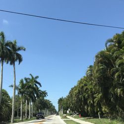
Scenic Drive in Fort Myers Beach, Florida
Lighthouses in Fort Myers Beach, Florida
Scenic Overlook in Fort Myers Beach, Florida
Places to Walk Around in Fort Myers Beach, Florida
Chapel in Fort Myers Beach, Florida
Beautiful Views in Fort Myers Beach, Florida
Beach in Fort Myers Beach, Florida
Places to Walk at Night in Fort Myers Beach, Florida
Scenic Night View in Fort Myers Beach, Florida
Attractions in Fort Myers Beach, Florida
Fun Things to Do With Teens in Fort Myers Beach, Florida
Historical Sites in Fort Myers Beach, Florida
Photo Spots in Fort Myers Beach, Florida
Young Crowd in Fort Myers Beach, Florida
Field Trips in Fort Myers Beach, Florida
Hidden Gems in Fort Myers Beach, Florida
Trending Searches in Fort Myers Beach, FL
4th Of July Fireworks near Estero Island
Black Owned Nail Salons near Estero Island
Boat Rental near Estero Island
Flower Fields near Estero Island
Jet Ski Rental near Estero Island
Kayak Rental near Estero Island
Landmarks & Historical Buildings near Estero Island
Lighthouses near Estero Island
Picnic Areas near Estero Island
Places To Visit near Estero Island
Places To Walk Around near Estero Island
Public Pools near Estero Island
River Swimming near Estero Island
Scenic Restaurants near Estero Island
Secluded Spots near Estero Island
Sightseeing near Estero Island
Soccer Store near Estero Island
Strawberry Picking near Estero Island
Swimming Holes near Estero Island
Swimming Lakes near Estero Island
Things To Do This Weekend near Estero Island
Things To See near Estero Island
Browse Articles
Browse Nearby
BEST of Fort Myers Beach, Florida Restaurants near Estero Island
BEST of Fort Myers Beach, Florida Coffee near Estero Island
BEST of Fort Myers Beach, Florida Things to Do near Estero Island
BEST of Fort Myers Beach, Florida Shopping near Estero Island
BEST of Fort Myers Beach, Florida Breakfast near Estero Island
BEST of Fort Myers Beach, Florida Beaches near Estero Island
Browse Brands
Related Searches in Fort Myers Beach, FL
Best Fun Things to Do in Fort Myers Beach, Florida
Best Nature Trails for Hiking in Fort Myers Beach, Florida
Book Engaging Historical Tours in Fort Myers Beach, Florida
Discover Charming Historic Homes in Fort Myers Beach, Florida
Discover Free Parking Options in Fort Myers Beach, Florida
Discover Popular Photo Spots in Fort Myers Beach, Florida
Discover Top State Parks to Visit in Fort Myers Beach, Florida
Discover the Best Beaches in Fort Myers Beach, Florida
Discover the Best Interactive Museum in Fort Myers Beach, Florida
Discover the Best Military Museum in Fort Myers Beach, Florida
Enjoy Scenic Night View Experiences in Fort Myers Beach, Florida
Enjoy the Best Night View Spots in Fort Myers Beach, Florida
Enjoy the Best Walking Trails in Fort Myers Beach, Florida
Experience Stunning Sunset Views in Fort Myers Beach, Florida
Explore Beautiful Botanical Gardens in Fort Myers Beach, Florida
Explore Beautiful Castles and Landmarks in Fort Myers Beach, Florida
Explore Beautiful Parks and Green Spaces in Fort Myers Beach, Florida
Explore Children's Museums Near Fort Myers Beach, Florida
Explore Free Things to Do Around Fort Myers Beach, Florida
Explore Fun Activities to Do in Fort Myers Beach, Florida
Explore Fun Field Trips in Fort Myers Beach, Florida
Explore Nature Spots Around Fort Myers Beach, Florida
Explore Popular Scenic Overlook Points in Fort Myers Beach, Florida
Explore Popular Scenic Views Near Fort Myers Beach, Florida
Explore Secret Spots Worth Visiting in Fort Myers Beach, Florida
Explore Top Art Galleries Located in Fort Myers Beach, Florida
Explore Top Haunted Places Near Fort Myers Beach, Florida
Explore Venues & Event Spaces in Fort Myers Beach, Florida
Explore Vibrant Public Art Displays in Fort Myers Beach, Florida
Find Beautiful Views in Fort Myers Beach, Florida
Find Exciting Tours to Take in Fort Myers Beach, Florida
Find Top Art Museums in Fort Myers Beach, Florida
Find Top Libraries to Visit in Fort Myers Beach, Florida
Find the Best Bridge Spots in Fort Myers Beach, Florida
Find the Best Playgrounds to Visit in Fort Myers Beach, Florida
Must-See Tourist Attractions Around Fort Myers Beach, Florida
Popular Picnic Spots to Visit in Fort Myers Beach, Florida
Popular Places to Take Pictures in Fort Myers Beach, Florida
Popular Places to Walk Around in Fort Myers Beach, Florida
Popular Things to Do in Fort Myers Beach, Florida
Popular Things to See in Fort Myers Beach, Florida
Top Hiking Trails to Explore in Fort Myers Beach, Florida
Top Historic Restaurants to Try in Fort Myers Beach, Florida
Top Museums for Kids to Visit in Fort Myers Beach, Florida
Top Things to Do With Kids in Fort Myers Beach, Florida
Tour Famous Lighthouses Located in Fort Myers Beach, Florida
Visit Popular Museums in Fort Myers Beach, Florida Now
Visit a Free Museum Near You in Fort Myers Beach, Florida
Visit the Train Museum in Fort Myers Beach, Florida
Where to Catch the Best Sunrise View in Fort Myers Beach, Florida
People who viewed Estero Island also viewed
Downtown Bonita Springs
2 reviews
First Street
5 reviews
Iwo Jima Monument
2 reviews
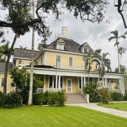
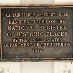
Murphy - Burroughs House
6 reviews
Fort Myers Beach Public Library
11 reviews
Southwest Florida Military Museum & Library
1 review
Sanibel Public Library
13 reviews
Matanzas Bridge Fishing Pier
2 reviews
Matlacha Pass Bridge
2 reviews
LittleFreeLibrary
1 review