Franklin Falls Trailhead Photos


You might also consider
More like Franklin Falls Trailhead
Recommended Reviews - Franklin Falls Trailhead
Start your review...

Reviews With Photos

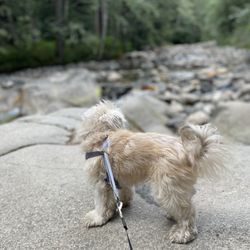
Beautiful day in nature. There are a few new signs begging people to keep their dogs leashes AND not leave poop bags, but alas there was one on the trail. It's easy- if you cannot hold a pop bag the entire time while hiking DO NOT BRING YOUR DOG... and keep your dogs all on leashes. After arriving at the falls there was a couple with three dogs and all of them were off leash. It's not ok for dogs to be wandering around possibly leaving their poop and approaching other dogs. The trail was pretty as always.

On a nicely manicured trail, down a shady road, up near snoqualmie pass, lies this delightful waterfall! We've been driving over Snoqualmie pass for darn near 40 years, and I had no idea this was here. From the waterfall, you're able to see the westbound lanes as you're descending the west side of Snoqualmie pass. The trail is well marked, and more manicure than we are generally used to. While it was a really nice hike, it honestly took a little bit away from it. That said, it's one we would do again. We don't hike on the side of the mountains very often, so we've forgotten how busy it would be on a Saturday. We were lucky to find a place to park, but do be ready to spend a little bit of time circling. They were probably 1000 people that we saw on the trail, and a few hundred down near the waterfall, including the number of groups that were swimming underneath it. It still remains very picturesque, and is the sort of place. It's nice to hike with friends, especiallyif you have younger kids. It's not a particularly difficult trail, and other than a slight descent to the waterfall, it's not much different than walking through a park.

Simply breathtaking, any time of year. It's a bite-sized creekside "hike" / nature walk to a wonderful waterfall at the end. Discovery NW Pass required. If you are going to do this hike, please be respectful of nature ^___^ Keeping our trails trash free preserved the beauty for us all (critters included!) I just love the PNW.

A friend had posted photos of waterfall and I just knew I had to come here. On a few different trail and hiking ops, it rated this as an easy trail. 1 mile there, 1 mile back and about an hour for the hike. But what I feel no one mentioned is that the hike there is ALL UPHILL. All of it. According to my watch it was almost a 400ft elevation gain. There are areas where there are stairs that made on the pathway but some of the stairs have a tall height. But the trail and path is wide enough in 99% of the areas so that it's easy to pass other hikers. There are a few sections where you can easily rest on the way up on the trail without blocking anyone walking on the trail so that is a very nice benefit. When you get close to the waterfall, the path ends and you have to navigate on rocks to get to the waterfall. As someone who doesn't always balance so well, I did need some assistance. The water from the waterfall is so clear and beautiful. There is something so soothing about being in nature like that. Surrounded by greenery, water sounds and fresh air. Going back down the trail is much faster since you are going down but for someone with bad knees the height of the stairs sometimes made it an issue when going down. It was better for me to walk on the outside of the stair instead. Overall highly recommend. It's beautiful and a great hike.

")
Went on a short hike today to see the big Waterfall. Parking was kind of difficult to find since there were a lot of people there. Luckily, we found one space in the main Visitor Parking lot when someone had pulled out. Just some cars were parked very close to each other. Some people can be very inconsiderate of others. We also witnessed several people driving down the wrong way and entering in where it clearly shows a DO NOT ENTER sign!!! Stupid people... The short walk up to the Waterfall was great! Enjoyed the nice weather, good trail and took a whole lot of pictures. Very scenic for the most part.

The falls are ok, but the trail is the highlight. We parked in the large lot up the hill past the first trailhead we spotted. We hopped on the trail here and completed the Wagon Road to Franklin Falls trail loop...through the gorgeous forest...down the slippery steps for a brief viewing of the falls...along the beautiful Snoqualmie River...past the adorable cabins...and back around to the opposite end of the parking lot. Sure the falls are pretty, but I enjoyed the hike more...beautiful place!

We have been to Franklin fall in the summer many times. This is our first time snowshoeing to the fall on a very merry white Christmas Day. Instead of going from the trail head parking lot. We came down from the Summit at snoqualmie all the way down to the fall. The walk was super beautiful and the kids get to play in the snow and even grab a few popsicles (icicles) to eat and play with. This is an amazing winter wonderland and the perfect day to hang outdoors with the family.
We hike here a fair bit, despite it being 40min drive from home. Love the hike, it's beautiful. Waterfall is beautiful. The creek is serene and clean. You can see the bottom of the creek. It's just an amazing site/sight :) The bathrooms however - DISGUSTING. People need to treat public facilities better. Recommend the hike, avoid the convenience.

So easy to get to, yet so pretty! My uncle decided to take my family and I here after seven years. I recall that the last time we went, it was rainy and a bit slippery, but this time around, it was perfectly sunny. The wooden bridge to get to the trailhead was nice to take photos on, and the trail to get to the fall itself was nicely maintained. And boy, were the falls beautiful! You can walk pretty close to it on the rocks- def nice for photo ops. Def coming on out again if I want an easy, yet pretty getaway.


We found this to be a beautiful and leisurely hike with a rewarding end. It's a pretty popular hike even though it's a decent drive from the city, so plan to arrive early or give it a visit on a weekday. The parking lot is right at the trailhead and takes the NW Forest Pass. It's a pretty mild hike with only 2 miles roundtrip and a 400 ft elevation gain. The trail is pretty smooth and well maintained. There are two vista points, one directly on the trail and the second you can climb the rocks to go right up to the base of the waterfall. The trail is shaded the whole way so you don't have to worry too much about the sunscreen. The falls themselves are beautiful at 135 ft of total waterfall and an icy cold pool of water at its base. The trees and natural PNW forest are an incredible backdrop making these falls a breathtaking sight. There's lots of places to sit on rocks and just enjoy the water, that is if there aren't too many people around. We took the Wagon Road Trail back to the parking lot which completes a nice loop and was less trafficked than the in and out Franklin Falls Trail. It's a well worthy hike and perfect for a quick outdoor experience.

Great PNW day trip. I would recommend for all ages. Please keep in mind this is a hike and dress accordingly. Once you reach the falls the rocks are slippery and if you plan on getting close to the falls for a great shot you my get your feet wet. I plan on returning again with other family members and it friends. Absolutely stunning natural landscape, easy access and easy hike. Some inclines and a few fallen tree you will need to go over, under or around but not with much difficulty. Some areas have a steep open drop overlooks. So keep kids and animals close. read more


9 years ago
So we decided to come pay a visit as our family is here and we did not want to impose a strenuous hike on them. Franklin falls trail was just perfect for them. 2 mile Round trip from the trail head with 400 ft gain , this hike is great for everybody. Given the easiness , people who come here mostly don't have trail etiquette which you just have to be ok with. If you are fast paced you might want to ask yourself to be excused as most people wont bother asking. But aside from all that a decent view and a well kept trail will make this a short nice walk with family. Once you reach the falls , there is a nice area where you can enjoy the cold water and kiddos and furry family can have their share of fun as well. Mostly good vibes!!! I got bitten by mosquitoes while I was waiting for the others . My family didn't seem to have a problem . I would suggest to avoid wearing black or any dark color for that matter. I was wearing black tights and that sure attracted them. Also parking is hard to find . We got lucky and scored the spot while someone was leaving. But it's better to get here nice and early to avoid circling around for a spot. Also don't forget to carry your Northwest Pass or America the great pass and hang them in your cars. Happy trails! read more


9 years ago
My favorite falls so far! This was a beautiful and easy 2 mile round trip walk from the parking lot at the bottom. The falls itself is located underneath the Denny Creek Viaduct (the bridge above the trees on I-90). The rocks at the end of the path closer to the falls are very slippery, so be careful. We went in July 2017 and the falls were quite heavy. I loved it. read more


6 years ago
Beautiful place but please clean the restrooms felty no toilet paper and very nasty please take care of it . read more

6 years ago
9 years ago
An easy hike with awesome results! Two miles roundtrip (roughly three during the winter season). There's a small parking lot at the base of the hike and it's super close to various other trails (Denny Creek, Granite Mt, etc). This hike is relatively short and on the flatter side so expect a lot of traffic especially during the weekends and holiday breaks. I just went for the first time during the winter and it's absolutely beautiful. It's just as beautiful in the summer/spring but something about the snow and icicles makes this destination truly magical. The trail is covered in compacted snow so have some gear (poles/shoes) and dress warm! I saw too many noobs going solely for pictures (I get it, the PNW is beautiful) but cmon you really can't complain about the cold when you're simply wearing a tank with a plaid shirt (insert eye roll emoji). Especially when you get down to the falls, it gets slippery and you'll get wet when you get close to the falls. Dress warm and take it slow, it may be a short hike but snow/cold is no joke! I recommend this hike to everyone, so check it out for yourself! Note: if you're using google maps, put in the coordinates from the WTA website because the Franklin Falls Trail on google maps takes you a bit farther than where the trail actually is. read more


9 years ago
Franklin Falls....oh what a time. So a little background on myself, I'm definitely more of a couch-potato than a nature-enthusiast. But since I was in the Seattle area for vacation, I was down to do some exploring with my friends. Anyways this hike is not for the faint of heart. I believe it was a total of 9 or 10 miles round trip (depending on where you park). It's a great and beautiful hike, but can also be very strenuous for those who are not accustomed to long hiking distances. Here's some details about my trip to Franklin Falls: Me and a group of 4 other friends ventured out to this place roughly around 10:30am, didn't get back to our car until around 3:30pm. You can do the math (although we did frequently stop and took many pictures). Getting to this place can be fairly tricky, our GPS application kept rerouting us so it took us a while to actually get to the area. Tip: Use Google Maps instead of Apple Maps! So we get to the area, and some random lady tells us not to go up the road to where the trail begins due to traffic and bad road conditions. She was right! So we parked at the the very very base of the road (keep in mind this is not the base of the trail, we parked literally right next to the freeway). This in itself, made our trip much longer than most people. I believe it was a 3 mile trip just to get to the trail itself from our car. So yeah, if you park near the freeway, that's the distance you will have to traverse just to get to the trail. I also want to side note about the road conditions leading to the Franklin Falls trail. It's BAD. We went this past weekend and the roads were iced up like an ice skating rink. We even saw people get stuck in some parts of the road. I recommend parking at the base of the road and walking up to avoid this mess. That, or have really good AWD car...or chains could work too I guess. Anyways, so it's about a 3 mile hike from the base of the road to the actual trail itself. From there, it's another 2 miles to reach Franklin Falls. So in essence, 5 miles one way. Like I said, this hike tested my will to live....lol. I felt like quitting many times but my friends kept me going. Make sure you have the appropriate winter/snow gear because it's cold and slippery out there. I honestly think that the hike there was cooler than the actual waterfall. On the way there, you will encounter many places to take a cool instagram photo! From the frozen creeks to the snow-blanketed trees, this place is a winter wonderland during these months. As for the Falls itself, it is also very breathtaking. Frozen waterfalls, I mean, how cool is that? There is a specific part when getting down to the falls that some people might have trouble with. It's a semi-steep slope that requires you to hold onto a rope so you don't slip and fall. Other than that, it was pretty easy. Overall, Franklin Falls is a must! Make sure you bring a portable battery charger because you will be taking pictures for days. All I can say is to be ready for mother nature because I felt like I was on Man vs. Wild during the hike. This hike is definitely a bucket list item, and I am glad I can cross it off my list! Also check out my photos that I will be posting with this review. read more


9 years ago
Initially was scared about the icy conditions and crazy traffic heading into the trailhead to hike this falls based on recent reports but luckily it seems that when you go on a working day or a day after a major holiday, the volume wasn't too bad at all. I had a 2WD so I had to hike longer as I basically parked maybe 0.2-0.3 miles before the trailhead. I parked before the bridge to the trailhead. The hike from the trailhead was about 1 mile. Didn't see any cars parking near the trailhead. The hike was very nice but the road to the trailhead was icy and packed with snow. There was also a lot of potholes so be very careful! I bought online a Northwest pass for $5 in order to hike here. From Issaquah region, took about 40 minutes. Don't rely on Google maps to take you to Franklin Falls because it takes you to the wrong exist. Exit 47 is the correct one, take that, turn left and turn right and fork to the left when available and just follow the path to the trailhead. read more

Annemarie managed to convince me that it would be a good idea to go hiking in the winter, somehow. I'm still not sure how it happened but one sunny Sunday morning, after brunch, I found myself suddenly dressed in winter gears (all hers) and off we went on this 2-mile hike. It was relatively easy, even for a house cat like me. It was the start of winter and it had been snowing, so everything was covered in fluffy white, powdery snow and it was a beautiful winter wonderland. With my snow boots, it was actually easy to walk in the snow (and thankfully my boots are waterproof and I would highly recommend waterproof boots and jacket). I saw families with kids and small dogs (although a couple small dogs had to be carried). I love hikes that have a clear end and beginning (did I just use the words love and hike in the same sentence?!), and this is definitely one of those. This hike ends with a beautiful waterfall that I think is more gorgeous in the winter. It can be a bit tough to find the trailhead and also to find where to park, but otherwise, short hike + big reward = my kind of hike. read more


10 years ago
9 years ago
Roads were good in June. Alot of fun and easy trail. View is very nice but there are also alot of little stops you can make and enjoy views. Very family friendly trail. There is a $5 fee so bring cash! read more


9 years ago
One of the most fun hikes I've been on. We went during the winter (march) and this is usually when the waterfall is still frozen. It looks absolutely beautiful and I would say the trek is dog friendly! The road was closed to get to the parking lot because of the snow so the home that is usually a 2 mile hike was a 7.5 mile hike. Either way it was definitely worth it!! read more

9 years ago
Beautiful, short (less than)1 mile hike from the parking lot out to the falls. I definitely think children could do this easy- 400ft elevation and steady rising. I'm a pro photog that was visiting from Virginia- ended up bringing clients out here after I hiked it to do a shoot because I found it so beautiful(pictured). read more


9 years ago
Wear good shoes/boots....tred. Start early....no later than 1pm. Road closed in winter so its a 6mile hike and a dangerous spot at the end. Most people slide down at the end. REI has spikes i recommend them in the snow. read more

Family friend hike to an amazing waterfall. The trail head is located off exit 47 on I90 in the Denny Creek campground. The trail can get packed but there is sufficient parking. 2 mile round trip with some elevation gain to the bottom of the waterfall. Doable for all ages and dogs as well. Unlike Snoqualmie which is viewed from the top, here you walk to the base of the waterfall. There are options to walk down to the creek as well. Highly recommended. read more

8 years ago
11 years ago
This is a really neat hike. Supppper easy, not too long, and a beautiful waterfall at the end. Depending on the weather, the parking can be a little hectic but you'll eventually find some. Make sure to park in a spot with room so another car doesn't back into yours and not leave a note! The trail is well maintained and follows the creek/river so a lot of places to stop and either play in the water or get good pictures. At the end of the hike is the waterfall. We have taken a packed lunch and sat on the big rocks at the end in the sunlight and enjoyed lunch by the waterfall. It was a good weekend excursion not too far from home. It is pretty shady and follows the water so if it's not too hot out, keep that in mind. read more


A beautiful and easy hike for the winter! I went today (late November) and the fall at the end of the trail was half frozen. Though there wasn't enough snow to make a winter wonderland, the view was fabulous. If you are craving the outdoors in the winter and want an easy hike, I would absolutely recommend this one. read more

Hiked this on 4/10/2016. Got here at 4 pm. Found a lot of parking. Definitely recommend this. A lot of value for the distance. ~2 miles. Bought the Pacific Northwest forest pass from outdoor emporium in Seattle. You will need one. Costed me $5. When we hiked there was a lot of snow. That made it more fun. Bring extra socks. Will definitely go again!! read more

10 years ago
What an awesome place for a short hike. Loved how quiet it was and listening to the water the whole time. The closer you got to the water fall you could here the traffic from I-90 but to me I just toned it out and focused on the water sound. Nothing like nature to turn a not so good vacation into a tolerable one! This is a must when I visit this side of the state. The best part is that you are not that far from a camp ground...just down the the road so that will happen this summer! read more


9 years ago
Truly amazing!!! It's gorgeous! Just make sure you have AWD and snow chains. You can get stuck and it becomes a hassle. Just park off the exit of the freeway to avoid getting stuck if you don't have chains or a decent car to get though the icy roads (extra 5 miles added to the hike total of 7 if you park there)and don't listen to google maps . Take exit 47 from Seattle . read more


10 years ago
Amazing ice fall. You will deserve a 2 miles snow trail though sometimes you probably fall down to the smooth trail. It's also suitable for kids when it is slippery, they can slide to pass. So much fun! read more


10 years ago
This was a great hike for kids and beginning hikers as well. Strollers would not work but if you have a baby sling or hiking backpack, it works perfect. Wear slip proof shoes or hiking shoes for this one especially on those wet days, the last part of the trail just before the falls has some slippery rocks. It is a well cared for trail and there are beautiful scenery all the way in. But the falls itself is what makes this hike so awesome. We had three adults and two children (1yrs old & 6yrs old) so we packed a lunch and found a nice spot by the falls to eat. There is a lot of room but keep in mind it is mostly rocks. On the way out we stopped by the river and let the kids swim. Will definitely do this hike again when the little guy gets a little bigger. There is only one bathroom in the beginning of the hike, by the handicap parking. This is a popular trail so go early. Also, parking can be a little tricky for those bigger vehicles for once the road starts filling up there is only room for one car at a time. Happy trails!!! read more


10 years ago
10 years ago
What a beautiful, short hike! We have been here in the summer as well as just getting back from there this afternoon! I was hoping to see it in the snow and it definitely didn't disappoint me! We did have to park approx 3/4 of a mile from the trailhead as the road was blocked, then the hike to the falls is about a mile. So approximately 3 1/2 miles round trip. Very narrow road once everybody starts parking on both sides...ends up being a one lane road! It does get a little slippery in a few places, so make sure you have some shoes with traction. The falls are gorgeous as always! Oh, you do need a Discover Pass to park and explore here... read more


When planning my trip to Seattle, and my trip was only a quick three day trip, I still wanted to incorporate some nature into it. This hike was perfect. It wasn't too far of a drive away from the city (about an hour away). The hike wasn't strenuous at all, there were group of elementary school aged kids that I saw during the hike. Also good to bring dogs along too. And the site was amazing. Be mindful that you will need to have cash and a pen to fill out the parking pass for the day, which seems more of an honors system than anything. For summer early morning probably around 7-8 am there were a lot of cars already parked at the parking lot. The fall itself is so beautiful. I recommend visiting if you haven't yet :) read more


Took my LA friends on this hike and it was perfect in terms of distance, difficulty, and view. This hike is easy comparing it to rattlesnake, there isn't much incline/ crazy rocks/ or barriers. I see alot of parents taking kids on this hike so if they could do it, so can you! Also, was raining when we did this hike and it was still absolutely gorgeous. About a little over two miles roundtrip and it took us about 45 minutes. read more


8 years ago
12 years ago
12 years ago
Love love this place. So happy I went with my Lil family to do the 2 mile hike that ended at the waterfall. It was so beautiful. If you have little ones, make sure to help them down the stairs since they will be wet. Best time to visit this place is from June - October. read more


11 years ago
Super easy 2 mile round trip hike--great for out of town visitors, first time hikers, and kids. The tricky part was the big rocks near the falls which were a bit slippery, but with cautious steps, it's not that bad. I took my mom who was visiting from out of state, and she loved it. I knew I wanted to take her somewhere flatter with a view, and the drive was worth it. Expect to get a little wet from the mist of the falls. read more


10 years ago
Very beautiful falls and nice place to take kids and pets. You need to have a parking pass which is 5$ and needs to be displayed on your car dashboard. The parking is always almost full at the start of the trial head and difficult to get a spot. But there is another parking place if go ahead for another 0.5 miles from the parking at the trail head. This parking is not known to most of them and almost everyone will struggle for parking at the trial head. The total hike from the trial head is 1 mile. But if u park your car in another parking which 0.5 mile from the trial head, then you save 0.5 miles of hike and u will only need to hike for 0.5 miles to Franklin falls. The hike is pretty easy and enjoyable. read more


10 years ago
11 years ago
I took my son here for a mommy son date/hike. I was about 8 months pregnant and he was 4 years old. There were no bathrooms at the trail head. It was also hard to find, but maybe that's on me. According the WTA it was supposed to be a 2 mile hike with no incline. This hike, while short, was ALL incline. This wouldn't bother me normally but at the time I was just a big ole pregnant lady who just wanted an EASY trail to do with her son. My son ran ahead of me with ease and while at moments he did complain about being tired, I think he was just being lazy more than anything. He enjoyed himself. There was a place along the trail to go off and play in the river. My son had a ton of fun throwing rocks. Once you reach the waterfall the trail pretty much ends and you are walking on slippery rocks. This was scary for me as a pregnant uncoordinated mother trying to find her own balance while also helping her 4 year find his. My four year old was also unimpressed. We had a nice afternoon overall though. It's a short hike. Great for beginners and families. But I'd say boring if you're looking for something more challenging and with more sights. I don't think I'd drive out of my way again to do this hike. read more


10 years ago
12 years ago
This was such a beautiful place. First time checking it out & we'll be back for sure. It was a well maintained trail & what a beautiful payoff looking at that waterfall! Love it. read more


11 years ago
When I came to Washington to visit family - I immediatly said take me to a big waterfall and a lot of green. Well that is exactly what I got! What a fun hike - it was a really hot day so the cool water felt amazing. Kid friendly hike and trail - my kid was 5yrs. Beautiful location. read more

More info about Franklin Falls Trailhead
Denny Creek Campground
North Bend, WA 98045
Directions
(206) 625-1367
Call Now
Visit Website
http://www.wta.org/go-hiking/hikes/franklin-falls
Hours
Indoor Amenities
Outdoor Amenities
Other Amenities
Ask the Community - Franklin Falls Trailhead
Do they require parking pass or something if you're just going to pull over on the road?
Can I bring a baby?
Yes. There are some steep hills and cliffs but most of them have railings.
Review Highlights - Franklin Falls Trailhead
You might also consider


Why does Yelp recommend reviews?
1 review that is not currently recommended
The reviews below are not factored into the business's overall star rating.
12 years ago
Franklin Falls Trailhead - hiking - Updated July 2026
Best of North Bend
People found Franklin Falls Trailhead by searching for…
Sledding in North Bend, Washington
Hiking Trails With Waterfalls in North Bend, Washington
Lakes in North Bend, Washington
Ski Resorts in North Bend, Washington
Things to Do in North Bend, Washington
Swimming Holes in North Bend, Washington
Parks in North Bend, Washington
Long Term Rv Parking in North Bend, Washington
Places to Take Pictures in North Bend, Washington
Snow Play in North Bend, Washington
Swimming Lakes in North Bend, Washington
River Swimming in North Bend, Washington
Scenic View in North Bend, Washington
Scenic Drive in North Bend, Washington
Picnic Areas in North Bend, Washington
Photo Spots in North Bend, Washington
Easy Hikes in North Bend, Washington
Stairs Workout in North Bend, Washington
Scenic Spots in North Bend, Washington
Dog Friendly Things to Do in North Bend, Washington
Rv Campgrounds in North Bend, Washington
Trending Searches in North Bend, WA
4th Of July Fireworks near Franklin Falls Trailhead
Black Owned Nail Salons near Franklin Falls Trailhead
Boat Rental near Franklin Falls Trailhead
Cabins near Franklin Falls Trailhead
Cliff Jumping near Franklin Falls Trailhead
Crabbing Location near Franklin Falls Trailhead
Day Trips near Franklin Falls Trailhead
Dog Friendly Trails near Franklin Falls Trailhead
Fireworks near Franklin Falls Trailhead
Jet Ski Rental near Franklin Falls Trailhead
Kayak Rental near Franklin Falls Trailhead
Lakes near Franklin Falls Trailhead
Lakes & Ponds near Franklin Falls Trailhead
Long Term Rv Parking near Franklin Falls Trailhead
Nature Parks near Franklin Falls Trailhead
Outdoor Activities near Franklin Falls Trailhead
Parks For Picnics near Franklin Falls Trailhead
Picnic Spots near Franklin Falls Trailhead
Places To Walk Around near Franklin Falls Trailhead
Public Pools near Franklin Falls Trailhead
Public Shower near Franklin Falls Trailhead
River Swimming near Franklin Falls Trailhead
River Tubing near Franklin Falls Trailhead
Rock Quarry near Franklin Falls Trailhead
Rv Campgrounds near Franklin Falls Trailhead
Scenic Night View near Franklin Falls Trailhead
Scenic Overlook near Franklin Falls Trailhead
Secluded Spots near Franklin Falls Trailhead
Soccer Store near Franklin Falls Trailhead
Splash Pad near Franklin Falls Trailhead
Strawberry Picking near Franklin Falls Trailhead
Sunrise View near Franklin Falls Trailhead
Swimming Holes near Franklin Falls Trailhead
Swimming Lakes near Franklin Falls Trailhead
Watch Sunset near Franklin Falls Trailhead
Browse Nearby
Browse Brands
Related Cost Guides
Related Searches in North Bend, WA
Affordable Kayak Rental Services in North Bend, Washington
Affordable Long Term RV Parking in North Bend, Washington
Best Day Camps for Children in North Bend, Washington
Best Fishing Locations and Guides in North Bend, Washington
Best Nature Trails for Hiking in North Bend, Washington
Best Places for Horseback Riding in North Bend, Washington
Best Summer Camps for Kids Located in North Bend, Washington
Browse Charming Cabins in North Bend, Washington
Browse Top Hotels in North Bend, Washington for Your Stay
Browse Vacation Rentals to Book in North Bend, Washington
Check Out Off Road Trails in North Bend, Washington
Discover Dog Friendly Trails to Explore in North Bend, Washington
Discover Free Campgrounds in North Bend, Washington Area
Discover Scenic Beach Camping Sites in North Bend, Washington
Discover Scenic Mountain Bike Trails Near North Bend, Washington
Discover Scenic Waterfall Spots in North Bend, Washington
Discover Top Nature Parks to Visit in North Bend, Washington
Discover Top State Parks to Visit in North Bend, Washington
Discover Walking Parks in North Bend, Washington Near You
Discover a Hiking Trail in North Bend, Washington
Discover the Best Beaches in North Bend, Washington
Discover the Best Night Hike Trails in North Bend, Washington
Dog-Friendly Hikes With Dogs in North Bend, Washington
Enjoy Camping Adventures Around North Bend, Washington
Enjoy Exciting Mountain Biking Adventures in North Bend, Washington
Enjoy Hiking Adventures in North Bend, Washington
Enjoy Kayaking Adventures in North Bend, Washington
Enjoy RV Camping Adventures in North Bend, Washington
Enjoy Tent Camping Spots Around North Bend, Washington
Enjoy a Beautiful Waterfall Hike in North Bend, Washington
Enjoy the Best Picnic Spots and Ideas in North Bend, Washington
Enjoy the Best Walking Path in North Bend, Washington
Enjoy the Best Walking Trails in North Bend, Washington
Experience Thrilling White Water Rafting in North Bend, Washington
Explore Beautiful Parks and Green Spaces in North Bend, Washington
Explore Easy Hikes Perfect for All in North Bend, Washington
Explore Fun Activities to Do in North Bend, Washington
Explore Mobile Home Parks in North Bend, Washington Now
Explore Popular Campgrounds Near North Bend, Washington
Explore Popular Picnic Areas Around North Bend, Washington
Explore Scenic Lakes to Visit in North Bend, Washington
Explore Summer Camps for All Ages in North Bend, Washington
Explore Top Dog Parks in North Bend, Washington Near You
Explore Top Tent Campgrounds Near North Bend, Washington
Explore Top Water Parks in North Bend, Washington Today
Explore the Best Beach Spots in North Bend, Washington
Explore the Best Swimming Holes Around North Bend, Washington
Explore the Best Trail Options in North Bend, Washington