Freedom Falls Photos


More like Freedom Falls
Recommended Reviews - Freedom Falls
Start your review...


Reviews With Photos


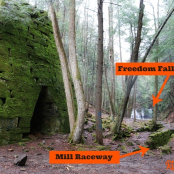
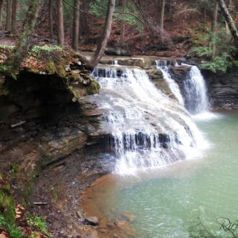
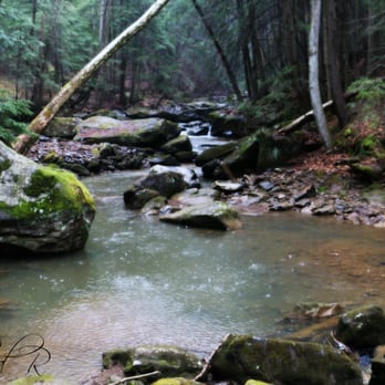
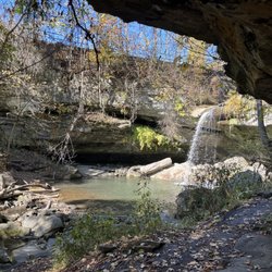
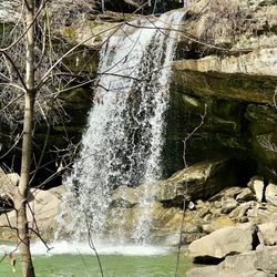
Freedom Falls seems to be a very overlooked, undermaintained waterfall between the towns of Wood Hill and Rockland, PA. As far as I could tell, Rockland Station Rd is the only way to access the falls by car. There are no visible markers telling you where the hiking trail begins to the falls, but there is a large boulder riddled in graffiti and a very small gravel parking area. The trail begins very steep, but eventually levels out. As you follow it you will notice through the trees it is a straight shot to the waterfall. The trail is less than a quarter of a mile walk and will take you less than 5 or 6 minutes to reach the falls. Getting to the base of the waterfall will be a tricky climb down a steep embankment using exposed tree roots, or you can follow the trail to the right for a slightly less acrobatic adventure. The waterfall itself is approximately 20 feet tall with a crest spanning nearly 60 feet wide. The water source is Shull Run, a tributary to the Allegheny River just a mile downstream. A large pool of water at the base of the fall awaits summertime visitors who want to cool off! It appears to be about 4 feet deep based on pics I've seen on other websites of people enjoying a dip in the cool waters. MORE THAT JUST A WATERFALL Another feature located near the falls is an old stone furnace built in 1832 that was used to process iron. Near it are the wheel pit and mill race. Further down Rockland road is another larger parking area. Here you can visit an old abandoned railroad tunnel built in 1915 that is about a half mile long. It's not a straight tunnel, but instead has a slight curve, which makes it impossible to see natural light at the other end until you are DEEP into the tunnel. It was too spooky for us so we only walked as far in as the light could penetrate! Very cool that you can see the original bricks used to line the tunnel as well as an occasional bat screech. A local told me that bats in the tunnel are an urban legend, but we heard a bat screech with our own ears. Maybe he wasn't a local at all, but Dracula himself trying to keep us out of his lair! Along the walls you will see arched niches that are said to be safety alcoves for anyone who found themselves trapped in the tunnel as a train approached. Today it is paved as part of the Allegheny River Bike Trail. FINAL THOUGHTS A hidden treasure for sure! Overall, I love the falls, the old blast furnace, and the spooky abandoned railroad tunnel, but dislike the lack of access and directional signage to the falls & furnace. Note that Rockland Road becomes a private road just past the parking area near the tunnel. Signage is clear that you are NOT WELCOME to enter beyond that point. 2016/76


1 month ago

11 months ago
very pretty, kinda hard to find if your not from the area but definitely worth to seeing if your willing to look ! read more

10 years ago
Freedom Falls seems to be a very overlooked, undermaintained waterfall between the towns of Wood Hill and Rockland, PA. As far as I could tell, Rockland Station Rd is the only way to access the falls by car. There are no visible markers telling you where the hiking trail begins to the falls, but there is a large boulder riddled in graffiti and a very small gravel parking area. The trail begins very steep, but eventually levels out. As you follow it you will notice through the trees it is a straight shot to the waterfall. The trail is less than a quarter of a mile walk and will take you less than 5 or 6 minutes to reach the falls. Getting to the base of the waterfall will be a tricky climb down a steep embankment using exposed tree roots, or you can follow the trail to the right for a slightly less acrobatic adventure. The waterfall itself is approximately 20 feet tall with a crest spanning nearly 60 feet wide. The water source is Shull Run, a tributary to the Allegheny River just a mile downstream. A large pool of water at the base of the fall awaits summertime visitors who want to cool off! It appears to be about 4 feet deep based on pics I've seen on other websites of people enjoying a dip in the cool waters. MORE THAT JUST A WATERFALL Another feature located near the falls is an old stone furnace built in 1832 that was used to process iron. Near it are the wheel pit and mill race. Further down Rockland road is another larger parking area. Here you can visit an old abandoned railroad tunnel built in 1915 that is about a half mile long. It's not a straight tunnel, but instead has a slight curve, which makes it impossible to see natural light at the other end until you are DEEP into the tunnel. It was too spooky for us so we only walked as far in as the light could penetrate! Very cool that you can see the original bricks used to line the tunnel as well as an occasional bat screech. A local told me that bats in the tunnel are an urban legend, but we heard a bat screech with our own ears. Maybe he wasn't a local at all, but Dracula himself trying to keep us out of his lair! Along the walls you will see arched niches that are said to be safety alcoves for anyone who found themselves trapped in the tunnel as a train approached. Today it is paved as part of the Allegheny River Bike Trail. FINAL THOUGHTS A hidden treasure for sure! Overall, I love the falls, the old blast furnace, and the spooky abandoned railroad tunnel, but dislike the lack of access and directional signage to the falls & furnace. Note that Rockland Road becomes a private road just past the parking area near the tunnel. Signage is clear that you are NOT WELCOME to enter beyond that point. 2016/76 read more




8 years ago
Took our kids to check out the falls, tunnel and hiking trail. Make sure to have a flash light of some sort for the tunnel- there is no lighting in there :) We will definitely be going back read more


7 years ago
5 years ago
6 years ago
10 years ago
More info about Freedom Falls
Rockland Station Rd
Kennerdell, PA 16374
Directions
Hours
Outdoor Amenities
Ask the Community - Freedom Falls
















Why does Yelp recommend reviews?
1 review that is not currently recommended
The reviews below are not factored into the business's overall star rating.

1 year ago
Freedom Falls - hiking - Updated August 2026
Best of Kennerdell
People found Freedom Falls by searching for…
Things to Do in Kennerdell, PA
Hiking Trails With Waterfalls in Kennerdell, PA
Off Road Trails in Kennerdell, PA
Walking Trails in Kennerdell, PA
Beautiful Views in Kennerdell, PA
Secret Spots in Kennerdell, PA
Mountain Biking in Kennerdell, PA
Swimming Lakes in Kennerdell, PA
Running Trails in Kennerdell, PA
Secluded Spots in Kennerdell, PA
Scenic Overlook in Kennerdell, PA
Scenic Views in Kennerdell, PA
Hiking With Kids in Kennerdell, PA
Lookout Points in Kennerdell, PA
Tent Camping in Kennerdell, PA
Swimming Holes in Kennerdell, PA
River Swimming in Kennerdell, PA
Trending Searches in Kennerdell, PA
Browse Articles
Browse Brands
Related Searches in Kennerdell, PA
Affordable Long Term RV Parking in Kennerdell, Pennsylvania
Best Fishing Locations and Guides in Kennerdell, Pennsylvania
Best Lookout Points to Visit in Kennerdell, Pennsylvania
Best Places for Horseback Riding in Kennerdell, Pennsylvania
Best Sightseeing Experiences Available in Kennerdell, Pennsylvania
Best Spots for Star Gazing in Kennerdell, Pennsylvania
Best Waterfalls and Swimming Holes in Kennerdell, Pennsylvania
Check Out Off Road Trails in Kennerdell, Pennsylvania
Discover Popular Photo Spots in Kennerdell, Pennsylvania
Discover Romantic Views in Kennerdell, Pennsylvania
Discover Scenic Beach Camping Sites in Kennerdell, Pennsylvania
Discover Stunning Skyline View Spots in Kennerdell, Pennsylvania
Discover the Best Night Hike Trails in Kennerdell, Pennsylvania
Enjoy Camping Adventures Around Kennerdell, Pennsylvania
Enjoy Scenic Night View Experiences in Kennerdell, Pennsylvania
Enjoy Tent Camping Spots Around Kennerdell, Pennsylvania
Enjoy the Best Night View Spots in Kennerdell, Pennsylvania
Enjoy the Best Picnic Spots and Ideas in Kennerdell, Pennsylvania
Enjoy the Best Tubing Experiences in Kennerdell, Pennsylvania
Enjoy the Best Walking Trails in Kennerdell, Pennsylvania
Explore Beautiful Parks and Green Spaces in Kennerdell, Pennsylvania
Explore Landmarks & Historical Buildings in Kennerdell, Pennsylvania
Explore Popular Campgrounds Near Kennerdell, Pennsylvania
Explore Popular RV Parks Around Kennerdell, Pennsylvania
Explore Popular Scenic Overlook Points in Kennerdell, Pennsylvania
Explore Popular Scenic Views Near Kennerdell, Pennsylvania
Explore Popular State Park Destinations in Kennerdell, Pennsylvania
Explore Popular View Points Around Kennerdell, Pennsylvania
Explore Scenic Lakes to Visit in Kennerdell, Pennsylvania
Explore the Best Swimming Holes Around Kennerdell, Pennsylvania
Find Beautiful Views in Kennerdell, Pennsylvania
Find Cozy Camping Cabins in Kennerdell, Pennsylvania
Find Top-Rated Waterfalls in Kennerdell, Pennsylvania Now
Find the Best Scenic View Locations in Kennerdell, Pennsylvania
Hiking Trails With Waterfalls in Kennerdell, Pennsylvania
Locate a Public Shower Facility in Kennerdell, Pennsylvania
Must-See Tourist Attractions Around Kennerdell, Pennsylvania
Plan a Scenic Drive Route Near Kennerdell, Pennsylvania
Popular Kids Activities in Kennerdell, Pennsylvania
Popular Places to Take Pictures in Kennerdell, Pennsylvania
Popular Things to Do in Kennerdell, Pennsylvania
Popular Things to See in Kennerdell, Pennsylvania
Relax at Natural Hot Springs Near Kennerdell, Pennsylvania
See Top Fireworks Events in Kennerdell, Pennsylvania
Top RV Campgrounds to Visit in Kennerdell, Pennsylvania
Top Things to Do With Teenagers in Kennerdell, Pennsylvania
Top-Rated Camping Sites in Kennerdell, Pennsylvania
Where to Catch the Best Sunrise View in Kennerdell, Pennsylvania


