French Valley Wildlife Area Photos


You might also consider
More like French Valley Wildlife Area
Recommended Reviews - French Valley Wildlife Area
Start your review...

5 months ago
Drove about 30 minutes to check this trail out and it was a complete disappointment. The location is misleading and the parking situation is way worse than what old reviews make it sound like. First off, the "parking" isn't a parking lot at all -- it's literally a small dirt/grass hill on the side of the road. It's not obvious, easy to miss, and fits maybe 2-3 cars max. I had to do a U-turn just to even attempt parking. Once parked, I walked over expecting a trail entrance and instead found a short double-gated fence with locks on it. No clear entrance, no signage, no posted hours, nothing. I checked online and couldn't find any info saying it was closed. What made it worse is that older Yelp photos show a trail sign with the name on it -- that sign is completely gone now. The area honestly feels abandoned. This listing hasn't been updated in years, and that really shows. Save yourself the drive and frustration. Definitely not worth it. read more


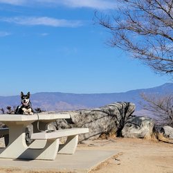
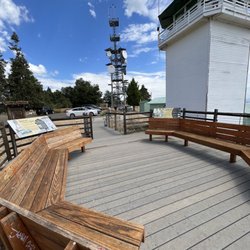
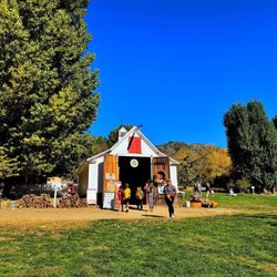
Didn't see any wildlife. But highly recommend a hike through this field. We're in Temecula and with Covid many of the wineries are either closed or very limited seating. So we thought what else is there to do. This place came up on Google Maps and instantly we got curious. Getting here is fairly straightforward. However there are no signs or banners or anything. Your gps directions will just abruptly end and you'll see a wooden structure that has the title French Valley Wildlife Area engraved in it. There's parking for about 5 cars right on site. From there, it's a very nice trial that goes throughout the flat land. We felt our spirits lifted seeing so much energy and space. Definitely a change from the congested city life. Can't wait to go back here again :) read more


3 years ago
More info about French Valley Wildlife Area
Buck Rd
Winchester, CA 92596
Directions
Visit Website
http://wildlife.ca.gov
Hours
Outdoor Amenities
You might also consider


Why does Yelp recommend reviews?
1 review that is not currently recommended
The reviews below are not factored into the business's overall star rating.
2 months ago
French Valley Wildlife Area - hiking - Updated July 2026
Best of Winchester
People found French Valley Wildlife Area by searching for…
Photo Spots in Winchester, California
River Swimming in Winchester, California
Hiking Trails in Winchester, California
Fishing Spots in Winchester, California
Sand Dunes in Winchester, California
Playgrounds in Winchester, California
Walking Trails in Winchester, California
Scenic View in Winchester, California
Scenic Drive in Winchester, California
Waterfall Hike in Winchester, California
Places to Take Pictures in Winchester, California
Flower Fields in Winchester, California
Free Things to Do in Winchester, California
Things to Do With Teenagers in Winchester, California
Picnic Areas in Winchester, California
Public Running Track in Winchester, California
Redwood Trees in Winchester, California
Secret Spots in Winchester, California
Sunset View in Winchester, California
Watch Sunset in Winchester, California
Basketball Courts in Winchester, California
Swimming Lakes in Winchester, California
Trending Searches in Winchester, CA
4th Of July Fireworks near French Valley Wildlife Area
Baseball Fields near French Valley Wildlife Area
Black Owned Nail Salons near French Valley Wildlife Area
Boardwalk near French Valley Wildlife Area
Boat Rental near French Valley Wildlife Area
Cliff Jumping near French Valley Wildlife Area
Day Trips near French Valley Wildlife Area
Dog Friendly Beaches near French Valley Wildlife Area
Fireworks near French Valley Wildlife Area
Fishing Spots near French Valley Wildlife Area
Jet Ski Rental near French Valley Wildlife Area
Kayak Rental near French Valley Wildlife Area
Lakes near French Valley Wildlife Area
Lakes & Ponds near French Valley Wildlife Area
Nature Trails near French Valley Wildlife Area
Off Road Trails near French Valley Wildlife Area
Outdoor Activities near French Valley Wildlife Area
Outdoor Basketball Courts near French Valley Wildlife Area
Paddle Boat Rentals near French Valley Wildlife Area
Parks For Picnics near French Valley Wildlife Area
Places To Walk Around near French Valley Wildlife Area
Public Pools near French Valley Wildlife Area
Public Shower near French Valley Wildlife Area
River Swimming near French Valley Wildlife Area
Rock Quarry near French Valley Wildlife Area
Scenic Overlook near French Valley Wildlife Area
Secluded Spots near French Valley Wildlife Area
Soccer Store near French Valley Wildlife Area
Splash Pad near French Valley Wildlife Area
Strawberry Picking near French Valley Wildlife Area
Sunrise View near French Valley Wildlife Area
Swimming Holes near French Valley Wildlife Area
Swimming Lakes near French Valley Wildlife Area
Watch Sunset near French Valley Wildlife Area
Browse Nearby
BEST of Winchester, California Restaurants near French Valley Wildlife Area
BEST of Winchester, California Things to Do near French Valley Wildlife Area
BEST of Winchester, California Coffee near French Valley Wildlife Area
BEST of Winchester, California Parks near French Valley Wildlife Area
BEST of Winchester, California Walking Trails near French Valley Wildlife Area
BEST of Winchester, California Breakfast near French Valley Wildlife Area
BEST of Winchester, California Hot Springs near French Valley Wildlife Area
BEST of Winchester, California Campgrounds near French Valley Wildlife Area
BEST of Winchester, California Motel near French Valley Wildlife Area
Browse Brands
Related Searches in Winchester, CA
Best Fishing Locations and Guides in Winchester, California
Best Fun Things to Do in Winchester, California
Best Nature Trails for Hiking in Winchester, California
Best Parks for Parties and Events in Winchester, California
Best Places for Horseback Riding in Winchester, California
Best Spots for Star Gazing in Winchester, California
Best Water Parks for Kids in Winchester, California
Check Out Great Playgrounds in Winchester, California
Discover Baseball Fields Around Winchester, California
Discover Dog Friendly Trails to Explore in Winchester, California
Discover Fun Activities to Do in Winchester, California
Discover Popular Bike Trails in Winchester, California
Discover Scenic Mountain Bike Trails Near Winchester, California
Discover Soccer Fields in Winchester, California Near You
Discover Top Nature Parks to Visit in Winchester, California
Discover a Hiking Trail in Winchester, California
Discover the Best Beaches in Winchester, California
Discover the Best Night Hike Trails in Winchester, California
Dog-Friendly Hikes With Dogs in Winchester, California
Enjoy Camping Adventures Around Winchester, California
Enjoy Exciting Mountain Biking Adventures in Winchester, California
Enjoy the Best Family Activities in Winchester, California
Enjoy the Best Picnic Spots and Ideas in Winchester, California
Enjoy the Best Walking Trails in Winchester, California
Experience Stunning Sunset Views in Winchester, California
Explore Beautiful Botanical Gardens in Winchester, California
Explore Beautiful Parks and Green Spaces in Winchester, California
Explore Bike Rentals Throughout Winchester, California
Explore Easy Hikes Perfect for All in Winchester, California
Explore Family-Friendly Zoos and Wildlife in Winchester, California
Explore Free Picnic Areas Around Winchester, California
Explore Fun Activities to Do in Winchester, California
Explore Landmarks & Historical Buildings in Winchester, California
Explore Parks With Pull Up Bars in Winchester, California
Explore Pickleball Courts in Winchester, California
Explore Popular Campgrounds Near Winchester, California
Explore Popular RV Parks Around Winchester, California
Explore Popular Recreation Centers Around Winchester, California
Explore Scenic Lakes to Visit in Winchester, California
Explore Top Dog Parks in Winchester, California Near You
Explore Top Gyms in Winchester, California Now
Explore Top Water Parks in Winchester, California Today
Explore the Best Beach Spots in Winchester, California
Explore the Best Boating Spots in Winchester, California
Family Friendly Hiking With Kids in Winchester, California
Find Batting Cages Near You in Winchester, California
Find Top Skate Parks in Winchester, California for All Skill Levels
Find Top Skating Rinks in Winchester, California for All Ages