
Palomar Mountain State Park Photos


You might also consider
More like Palomar Mountain State Park
Recommended Reviews - Palomar Mountain State Park
Start your review...

Reviews With Photos

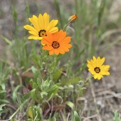
I had an opportunity to visit Palomar Mountain State Park last weekend as the Coved-19 crisis begins to unwind? Well, I hope it is unwinding now and we will be getting our lives back again soon. The state park is absolutely beautiful! There are so many places to hike and so much beautiful scenery that it's hard to describe in words. There was an explosion of wildflowers in a lot of the open areas, water was flowing in the creeks, and I hiked for several miles into lower French Valley - what a treat! The campgrounds were definitely not full, Even with only half the spaces being available. This is a bit unusual as this state park received lots of traffic from LA and San Diego. I hadn't been here for many years, and was glad to be able to spend the day hiking about. I'm a huge fan and recommend this place to anybody who has never been!

The Boucher trail (and the other trails that can make up a loop hike from the parking lot) is a good exploration around Palomar Mountain. Unfortunately, many trees here are burnt out in this area. Still, this is a fun family-friendly trail system. The Smaller Loop, Boucher to Scott's trail (4-5 miles). From the parking lot, walk up along the paved road to the Boucher trailhead. From there it's a mile hike uphill to the fire tower. Then you'll continue along the Boucher trail until it turns to the Adam's trail, then it turns into the Scott's trail. NOTE - An optional hike to Doane's Pond can be taken from here, the trail is called the Cedar Trail. But it you're looking to get back to the parking lot just continue down Scott's trail to Scott's Cabin, then look for the Scott's Trail Spur as a shortcut back to the parking lot... It was about 5 miles to do the Loop with the side hike to Doane's Pond. - The kids will love all the obstacles along these trails (fallen trees). - Like most mountain trails, there will be long periods of down and uphill hiking. - You paid $10 to park here. At least try and do a short loop hike.. - You'll need a GPS ( Google Maps on your phone) and maybe the free map at the ranger station to easily navigate the trails for a loop from the parking lot. - No wildflowers. - Lots of deer. - Restrooms.

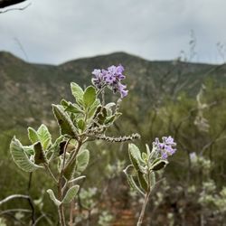
I LOVED the truly exceptional vistas on the drive up!! So inspiring and often clear skies. We went several times and it certainly was a high point and highlight of our time living in So Cal. T-Mobile Wi-fi is poor but has some spots of "sort of" reception. Keep your devices charged up. Take a comfy chair and a book if your inclined. There are several pull outs you can put up your feet and have loads of varying green through out primarily the south eastern horizon to look out onto, fresh air and expansive near 240 degrees, while enjoying a read or perhaps meditating and or listening to a podcast. The ground is all dirt with no grass or places for a blanket. However there are a few spots with some shade under a tree if you watch for them. Some traffic but not excessive dust and noise. Worth the drive and any minor inconveniences.


Doane valley campground: This is a very nice campground. Not what we are used to, we usually stay near water and swim or go tubing down the river. That is not the case here. There are alot of trails, hiking, fishing and the observatory is not too far. We did go fishing, there were lots of fish in the pond. The restrooms are very clean, the outhouse is also very clean. We booked 2 nights online but only stayed here one night. It is still too cold and unfortunately I forgot two cold weather sleeping bags at home, with that being said my boys slept very comfy and warm... but my husband and I were freezing. Awesome place, just make sure you pack correctly!

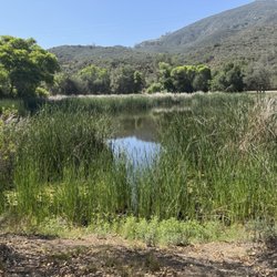
This is a very beautiful place. Camp sites are separated from one another with in a forest setting. Each site has a fire ring, grill and picnic table. There were RV sites but I don't know if there is electricity. There are flush toilets and a coin shower in the shower house and single toilet house within the park. Water is available between campsites. Be aware that some campsites are situated on a slight rise and may require walking up stone steps. Very quiet and peaceful. The night sky was wonderful. Doane Pond is within walking distance and there is a nice trail around it. We fished but didn't catch anything, not even a nibble. The pond is surrounded by cat tails, which are very beautiful but limit access to the water. There are plenty of hiking trails but no dogs are allowed on the trails. You can walk your dog on the road. There is one forest road that you can take your dog on also. They have fire pits and there were no fire restrictions when we were there 10/14-15/2020. The only negative was the incredible preponderance of flies and bees that swarmed us during the day. They seem to be worse when it was hot. The bees were attracted to the water faucet and I got stung on the finger while running the tap. The flies did not bite or sting but they were very annoying. We drove up to the fire lookout tower and watch the sunset. They actually have an observation deck there. On clear days you can see to Tijuana, the ocean and San Diego.


There was no one at the gate. Confused I pulled into the parking space and walked over to the gate. Got an envelope wrote my plate no. placed my $10 and I had to fold & stuff it into the box. It was packed with people paying money for entrance fee. That part was little annoying. What a great place for early spring foraging-young ferns. There were ferns everywhere. Inside & outside of the park Be careful. You have to soak them or boil them in water to remove natural toxins from the plant. You would need to go probably in March. Anyway we walked small trail up the mountain. About half way we were able to see the valley below. Since covid-19 pandemic the air is clear and we were able to see mountain ranges far as eyes can see. Still green from winters rain. Some of us wore masks and we kept our distance. We continued with the trail and final destination was out to the road outside of the park. What??? We walked along the shoulder back into the park. without the rangers. Drive carefully, have good tires, windy road can cause loss of control of the wheel.

Decided to go visit Palomar State Park. I wasn't able to find the park entrance when I got up the mountain from taking S Grade Rd. ****(Make a left when you get to the top, then another quick left turning into Mother's kitchen which is State Park Rd. Go all the down until you get to the state park entrance) We paid our fee of $10 per vehicle (there is a box to insert your deposit or pay inside the office). If you stop in the ranger's office, you are able to get a map of the park, info about camping, and chat with the ranger. We walked the Doane Trail, then headed to Weir Lookout Trail where there is a old structure located next to the stream. The view is really nice. Walking back to the parking lot, we went to check out the pond. Then walked to up to Scott's Cabin, this a somewhat intense trail due to the altitude. I wish someone would have told us there is NO cabin to Scott's Cabin. Only scattered logs remain at the site.

This is a really awesome campground. We stayed at Campsite 21 which we loved because it was backed up to the forest. The other campsites are more on top of one another. Flies were a big issue but that comes with the seasons. The bathrooms were very clean and the rangers were very kind. We went on a few hikes but avoided the tall grass as we heard many rattlesnakes trying to pass through. Overall it was a really great and fun experience and we will be back!

I just love this place. Been coming here since i was a young lad. The views are breathtaking. Make sure you make the big view stop on the south grade. Its really big so you wont miss it. The picnic opportunities are amazing here as well. There is a nice table up at the peak by the fire watch tower. Pit Bathrooms close by too. If you see someone by the tower you can ask for a tour and theu will. Last time we went it was freezing cold butnot cold enough to snow (well the next morning it was covered in a blanket of snow) so it was so close that we actually pulled over and made some hot chocolate lol. Yeah we roll like that! Camping spots are open year around even in snow. Fire restrictions apply. If you come up through the east grade (lake henshaw side) you also get a very nice view point of the lake. So come up on the south grade and down on the east grade. Make sure you have good brakes because they might smoke going down hill. Come down on lower gear but dont drag your transmission. Google it! Well ill keep adding to this review im sure.

We parked at the ranger station about 3 miles from the lake. We took the chimney flats trail to the lake and then hiked the weir loop and went the same way back. The total we did was a little over 9 miles. The campground around the lake is beautiful and well kept, good for kids and family activities. PS if you are using Alltrails map the starting point to the trail is wrong!

1 year ago
4 years ago
Getting there: Depends on where you're coming from, but you'll want to find your way to the 76 highway. Make sure to set the directions on your maps app before you lose service because you will not have service at the campsite. Experience: This was one of the best campsites I've been too. It was clean, but also tucked away so you didn't hear cars on the highway or anything. We didn't arrive to our site until later at night on a Friday, but when we woke up in the morning we saw that we were literally above the clouds. It was amazing. The site has showers towards the entrance as well as flushable toilets and spouts at the sites. These campsites are booked months in advanced so if you plan on checking out this hidden oasis, I would recommend booking sooner than later. read more

I had an opportunity to visit Palomar Mountain State Park last weekend as the Coved-19 crisis begins to unwind? Well, I hope it is unwinding now and we will be getting our lives back again soon. The state park is absolutely beautiful! There are so many places to hike and so much beautiful scenery that it's hard to describe in words. There was an explosion of wildflowers in a lot of the open areas, water was flowing in the creeks, and I hiked for several miles into lower French Valley - what a treat! The campgrounds were definitely not full, Even with only half the spaces being available. This is a bit unusual as this state park received lots of traffic from LA and San Diego. I hadn't been here for many years, and was glad to be able to spend the day hiking about. I'm a huge fan and recommend this place to anybody who has never been! read more


The Boucher trail (and the other trails that can make up a loop hike from the parking lot) is a good exploration around Palomar Mountain. Unfortunately, many trees here are burnt out in this area. Still, this is a fun family-friendly trail system. The Smaller Loop, Boucher to Scott's trail (4-5 miles). From the parking lot, walk up along the paved road to the Boucher trailhead. From there it's a mile hike uphill to the fire tower. Then you'll continue along the Boucher trail until it turns to the Adam's trail, then it turns into the Scott's trail. NOTE - An optional hike to Doane's Pond can be taken from here, the trail is called the Cedar Trail. But it you're looking to get back to the parking lot just continue down Scott's trail to Scott's Cabin, then look for the Scott's Trail Spur as a shortcut back to the parking lot... It was about 5 miles to do the Loop with the side hike to Doane's Pond. - The kids will love all the obstacles along these trails (fallen trees). - Like most mountain trails, there will be long periods of down and uphill hiking. - You paid $10 to park here. At least try and do a short loop hike.. - You'll need a GPS ( Google Maps on your phone) and maybe the free map at the ranger station to easily navigate the trails for a loop from the parking lot. - No wildflowers. - Lots of deer. - Restrooms. read more


4 years ago
I LOVED the truly exceptional vistas on the drive up!! So inspiring and often clear skies. We went several times and it certainly was a high point and highlight of our time living in So Cal. T-Mobile Wi-fi is poor but has some spots of "sort of" reception. Keep your devices charged up. Take a comfy chair and a book if your inclined. There are several pull outs you can put up your feet and have loads of varying green through out primarily the south eastern horizon to look out onto, fresh air and expansive near 240 degrees, while enjoying a read or perhaps meditating and or listening to a podcast. The ground is all dirt with no grass or places for a blanket. However there are a few spots with some shade under a tree if you watch for them. Some traffic but not excessive dust and noise. Worth the drive and any minor inconveniences. read more

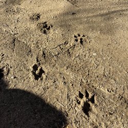
Beautiful park with benches so you can sit and enjoy, or move around and see lots of trees. I actually went for a hike and found a pack of dogs roaming out here that had no owner...be careful in the woods alone and only go during the daytime. read more


7 years ago
Doane valley campground: This is a very nice campground. Not what we are used to, we usually stay near water and swim or go tubing down the river. That is not the case here. There are alot of trails, hiking, fishing and the observatory is not too far. We did go fishing, there were lots of fish in the pond. The restrooms are very clean, the outhouse is also very clean. We booked 2 nights online but only stayed here one night. It is still too cold and unfortunately I forgot two cold weather sleeping bags at home, with that being said my boys slept very comfy and warm... but my husband and I were freezing. Awesome place, just make sure you pack correctly! read more


6 years ago
This is a very beautiful place. Camp sites are separated from one another with in a forest setting. Each site has a fire ring, grill and picnic table. There were RV sites but I don't know if there is electricity. There are flush toilets and a coin shower in the shower house and single toilet house within the park. Water is available between campsites. Be aware that some campsites are situated on a slight rise and may require walking up stone steps. Very quiet and peaceful. The night sky was wonderful. Doane Pond is within walking distance and there is a nice trail around it. We fished but didn't catch anything, not even a nibble. The pond is surrounded by cat tails, which are very beautiful but limit access to the water. There are plenty of hiking trails but no dogs are allowed on the trails. You can walk your dog on the road. There is one forest road that you can take your dog on also. They have fire pits and there were no fire restrictions when we were there 10/14-15/2020. The only negative was the incredible preponderance of flies and bees that swarmed us during the day. They seem to be worse when it was hot. The bees were attracted to the water faucet and I got stung on the finger while running the tap. The flies did not bite or sting but they were very annoying. We drove up to the fire lookout tower and watch the sunset. They actually have an observation deck there. On clear days you can see to Tijuana, the ocean and San Diego. read more


5 years ago
Absolutely BEAUTIFUL. I am in love with this state park! I wish I could live here. The trails are nice, everything is kept up, and nothing is better than fresh air! read more


There was no one at the gate. Confused I pulled into the parking space and walked over to the gate. Got an envelope wrote my plate no. placed my $10 and I had to fold & stuff it into the box. It was packed with people paying money for entrance fee. That part was little annoying. What a great place for early spring foraging-young ferns. There were ferns everywhere. Inside & outside of the park Be careful. You have to soak them or boil them in water to remove natural toxins from the plant. You would need to go probably in March. Anyway we walked small trail up the mountain. About half way we were able to see the valley below. Since covid-19 pandemic the air is clear and we were able to see mountain ranges far as eyes can see. Still green from winters rain. Some of us wore masks and we kept our distance. We continued with the trail and final destination was out to the road outside of the park. What??? We walked along the shoulder back into the park. without the rangers. Drive carefully, have good tires, windy road can cause loss of control of the wheel. read more


Decided to go visit Palomar State Park. I wasn't able to find the park entrance when I got up the mountain from taking S Grade Rd. ****(Make a left when you get to the top, then another quick left turning into Mother's kitchen which is State Park Rd. Go all the down until you get to the state park entrance) We paid our fee of $10 per vehicle (there is a box to insert your deposit or pay inside the office). If you stop in the ranger's office, you are able to get a map of the park, info about camping, and chat with the ranger. We walked the Doane Trail, then headed to Weir Lookout Trail where there is a old structure located next to the stream. The view is really nice. Walking back to the parking lot, we went to check out the pond. Then walked to up to Scott's Cabin, this a somewhat intense trail due to the altitude. I wish someone would have told us there is NO cabin to Scott's Cabin. Only scattered logs remain at the site. read more


7 years ago
This is a really awesome campground. We stayed at Campsite 21 which we loved because it was backed up to the forest. The other campsites are more on top of one another. Flies were a big issue but that comes with the seasons. The bathrooms were very clean and the rangers were very kind. We went on a few hikes but avoided the tall grass as we heard many rattlesnakes trying to pass through. Overall it was a really great and fun experience and we will be back! read more


4 years ago
I just love this place. Been coming here since i was a young lad. The views are breathtaking. Make sure you make the big view stop on the south grade. Its really big so you wont miss it. The picnic opportunities are amazing here as well. There is a nice table up at the peak by the fire watch tower. Pit Bathrooms close by too. If you see someone by the tower you can ask for a tour and theu will. Last time we went it was freezing cold butnot cold enough to snow (well the next morning it was covered in a blanket of snow) so it was so close that we actually pulled over and made some hot chocolate lol. Yeah we roll like that! Camping spots are open year around even in snow. Fire restrictions apply. If you come up through the east grade (lake henshaw side) you also get a very nice view point of the lake. So come up on the south grade and down on the east grade. Make sure you have good brakes because they might smoke going down hill. Come down on lower gear but dont drag your transmission. Google it! Well ill keep adding to this review im sure. read more


We parked at the ranger station about 3 miles from the lake. We took the chimney flats trail to the lake and then hiked the weir loop and went the same way back. The total we did was a little over 9 miles. The campground around the lake is beautiful and well kept, good for kids and family activities. PS if you are using Alltrails map the starting point to the trail is wrong! read more


6 years ago
Follow the Baptist, Fry Creek, Lower Doane and French Valley trails to be led through forests and flat-lands, and the chance to climb on stumps, jump through creeks, see deer run, inhale the fresh smell of mountain air, and free your soul. For real. Ah. If faeries and talking lions dwelled on this mountain, I wouldn't be surprised. This place is like magic. read more


10 years ago
It's nice to head up to the snow without having to go all the way to Julien or Big Bear! I had never been up to Palomar mountain before, despite my lifetime residence in North County San Diego. Windy drive expected :) Parking before the entrance of the park is fairly limited, though my family and I were fortunate to trek up here on a non-holiday, run-of-the-mill Monday afternoon, so parking-a-plenty. Breathtaking even with patches of snow on the ground (about 5 days after our big El Niño showdown), though I bet it's even more gorgeous when blanketed in the stuff! Plenty of places to hike and picnic! But be mindful, there are some slippery declines that make for an angry tail bone by nightfall. read more


5 years ago

8 years ago
Doane Valley Campground is a great place to camp. We stayed at #8 which was fairly level and close to the bathrooms. The campsites were clean and are equipped with water spigot, picnic tables, food storage box, and fire pit with small grill. The bathrooms were clean and coin operated hot showers are available. Cost per night is reasonable, $30 per night. State Park troopers are friendly and helpful. Lots of good trails for hiking and you can fish at Doane pond. I would definetly camp here again. read more


11 years ago
Drove up Sunday morning for some hiking. The trails were easy to locate and follow. It ranged from easy to moderate. The best part about this hike besides the panoramic view of north county, was the solitude of the mountains. I felt as if I had the whole park to myself. Great way to start the work week! I would definitely come back and go camping for a few days. read more


6 years ago
I've been camping at this spot three times previously. It is always a really fun time but some things have changed that recently make it not a great thing anymore. The fun things are the campsites there's usually a big thing of trees or rocks. The hiking is crazy fun and beautiful. What's up this time was that there are a million flies and meat bees everywhere. We literally lost our minds and had to leave early. Five of us out of 10 got stung and we could not continue on with important things that we wanted to do like hiking. The fishing was horrendous as there's only two spots to fish from the lake because the lake has been invaded by a tall species of Blade grass. I mean like the blade grasses 15 ft tall and it goes practically all around the lake preventing you from fishing and one of the spots that you can fish from there is a giant amount of some type of pondweed. This beautiful lake is now unaccessible. Will not go back camping until they fix the fly issue and clean up the lake read more

4 years ago
A quick hour or two drive from most any part of San Diego County leads you to the summit of Palomar Mountain. Too warm for you down at sea level? Take this drive and it could be snowing or slushy at the top. The air is so clean up here its refreshing, especially on cooler days. The Palomar Mountain Observatory is also here along with a general store/restaurant and a post office. Palomar Mountain State Park is nearby. Summer weekends the access road (County S-6) can be full of motorcycles trying to race up to the mountain summit. Go slow and careful. A nice place to get away from it all and yet be close to home, all within an easy day's drive. S6 is a fun route if you have a sports car and like to see how it handles. Highly recommended. read more

9 years ago
Camped here this July and loved it. There was a lot of bugs and mosquitos at camp but that's expected when you're camping! Just make sure to bring bug spray. I think we were at campsite 8 at the Doane Campground. read more


 campsite 8 - Parks Near Me - Palomar Mountain, California")
 campsite 8 - Parks Near Me - Palomar Mountain, California")
 campsite 8 - Parks Near Me - Palomar Mountain, California")
9 years ago
10 years ago
9 years ago
9 years ago
9 years ago
Easy hiking. Family friendly+++. I went alone mid-week, June 7-9; relatively quiet for day 1. Friday night invasion of the Dad/daughter weekend camping trip. Cute and carefree and happy noise. Only problem, I'm past that stage in my life. And how they got approval for 16 people on one campsite is beyond me! Very friendly Dads, and how great to get your kids outside, away from electronics! On the other side a family who put their tent almost on top of my site. Rude. Down the road, campers playing their music on their devices. Ugh. Left a night early . Go after school starts up...bet it will be lovely! The nature trail reminded me of hiking the Sierra. Don't miss the fire lookout! read more


9 years ago
Doane Valley is an awesome hike. Your at about 5000 ft and the hike only has a climb of about 450 ft max. Well established trails that hold up after rains with plenty of wildlife to see read more


8 years ago
15 years ago
Page 1 of 3
More info about Palomar Mountain State Park
19952 State Park Rd
Palomar Mountain, CA 92060
Directions
(760) 742-3462
Call Now
Visit Website
http://www.parks.ca.gov/default.asp?page_id=637
Hours
Indoor Amenities
Outdoor Amenities
Ask the Community - Palomar Mountain State Park
Where is the best place to camp out in car and watch the stars?
Are the showers onsite pay with quarters or free?
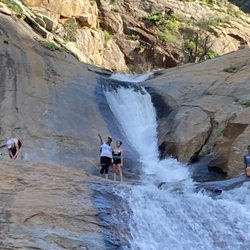
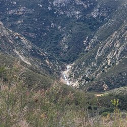
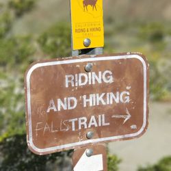
Are there any waterfalls nearby?
None in the park. Or near by that I am familiar with
On the website map for Doane campground it says "wifi" yet I've read people saying there's no cell service up there. Anyone know what the wifi symbol is on the campground map if there's no service then?
The upside down "wi-fi" looking icon is for the campfire center.
Do they have snow atm? Thank you.
No, snow won't be expected until around Oct. or so.
Review Highlights - Palomar Mountain State Park
You might also consider


Why does Yelp recommend reviews?
5 reviews that are not currently recommended
The reviews below are not factored into the business's overall star rating.
17 years ago
8 years ago
8 years ago
7 years ago
1 year ago
Palomar Mountain State Park - parks - Updated July 2026
Best of Palomar Mountain
People found Palomar Mountain State Park by searching for…
Campgrounds in Palomar Mountain, CA
Snow Play in Palomar Mountain, CA
Hiking Trails With Waterfalls in Palomar Mountain, CA
Things to Do in Palomar Mountain, CA
River Swimming in Palomar Mountain, CA
Fishing in Palomar Mountain, CA
Beaches in Palomar Mountain, CA
National Parks in Palomar Mountain, CA
Hot Springs in Palomar Mountain, CA
Camping Sites in Palomar Mountain, CA
Star Gazing in Palomar Mountain, CA
Water Parks in Palomar Mountain, CA
Dog Friendly Hiking Trails in Palomar Mountain, CA
Scenic Drives in Palomar Mountain, CA
Fishing Lake in Palomar Mountain, CA
Fall Foliage in Palomar Mountain, CA
Scenic Night Views in Palomar Mountain, CA
Free Campgrounds in Palomar Mountain, CA
Fishing Spots in Palomar Mountain, CA
Tent Camping in Palomar Mountain, CA
Nature Preserve in Palomar Mountain, CA
Family in Palomar Mountain, CA
Browse Nearby
BEST of Palomar Mountain, California Restaurants near Palomar Mountain State Park
BEST of Palomar Mountain, California Coffee near Palomar Mountain State Park
BEST of Palomar Mountain, California Things to Do near Palomar Mountain State Park
BEST of Palomar Mountain, California Breakfast near Palomar Mountain State Park
BEST of Palomar Mountain, California Campgrounds near Palomar Mountain State Park
Browse Brands
Browse Articles
People who viewed Palomar Mountain State Park also viewed
Hellhole Canyon County Preserve
22 reviews
Hot Springs Mountain
9 reviews
Eagle Rock Hike
56 reviews
Wilderness Gardens Preserve
21 reviews
Santa Ysabel Preserves
35 reviews
Inaja Memorial Park
9 reviews
Old Banner Toll Road
9 reviews
Black Canyon
4 reviews
South Carlsbad State Beach
382 reviews
Los Jilgueros Preserve
19 reviews