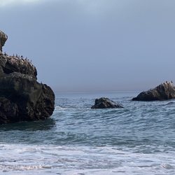
Julia Pfeiffer Burns State Park Photos


You might also consider
More like Julia Pfeiffer Burns State Park
Recommended Reviews - Julia Pfeiffer Burns State Park
Start your review...

Reviews With Photos

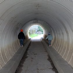
Friend wanted to see McWay Falls so we went Sat 6/17/23. It's over 2.5hrs to get there from Fremont. Entrances fee $10 or get CA public library state park pass, limited free parking on Hwy 1 if u want to walk-in. They have flushed toilets & sink but only 4, and only 3 were working when u went. Follow signs to McWay Falls, only 10min hike down the stairs, go through tunnel and turn right. Beautiful waterfall, can't go down to the beach, just see it from trail Worth a visit.

Breathtaking views! Some of the trails are still closed due to the 2020 Doran fire. We were able to hike the following: - McWay falls: Easy, flat trail (about a half mile there and back). Best seen in the afternoon so the shade isn't covering the falls. Some of the trail is fenced off so you can't go as far as you used to. - Partington cove: Gravel trail, mostly downhill and then uphill (about a mile total). There's a cute bridge that takes you through some Redwoods and then a cool tunnel before you arrive at the cove. Watch out for the poison oak! $10 for a day pass will get you into all the state parks. Both must do's at JPBSP!

We were lucky that this park was open during a weekend of park and beach closures. The more popular trails were closed, but we were able to get out of the car and stretch our legs a bit while getting some fresh air and sunshine. We didn't hike too long as it was pretty warm out but we did enjoy a bit of the park and have a chance to see some of the redwoods. Sometimes I feel a bit spoiled, while on the trail I didn't want to take the experience for granted but we were recounting the numerous amount of insane incredibly beautiful hikes in different locations that we've been on and sometimes it really makes you aware to count some of the smallest simplest things as magical because you're not always going to top previous experiences elsewhere. It's not often I'm on a trail and thinking seen one forest seen them all, or seen one valley view seen them all but we really have just seen so many gorgeous forests, valleys, waterfalls around the world that I did feel a bit like this place came up short for me. Maybe I was in one of my moods, who knows. Maybe the trails that were closed were obviously some of the greater pay off views. A nice place to get outdoors but if the trails you're coming for are closed I'd definitely say hiking in Yosemite, Sequoia other spots, or some National Parks just take the cake here. We parked outside of the park where a bunch of cars were and walked in. If there is parking available inside it's $10 cash.

Pre-covid review: Finally getting around to jotting thoughts for my trip earlier this year to Big Sur in February. I'm not sure even if we were able to see the closed off areas when we were here this year would've made this place any better, but it definitely feels a bit overhyped as a few others have mentioned. We were also interested in checking out the Ewoldsen Trail when we were here, but learned it was closed off due to damage when we were here, so we were left with McWay Falls on our planned itinerary and I was looking forward to it as one of the highlights of my trip. It was a bit underwhelming, athough the ocean does look very nice and I felt like I had to check the place out since I've already made my trek out to Big Sur. It probably only took us 30mins for us to see McWay Falls from when we parked at the lot, walked over to the overlook area, took pictures, and came back. Most people opted to park on the street, which would've been a good option if we had known it wasn't going to take us long to only see McWay Falls. We were thinking of sparing ourselves from walking further and paying for the added safety and convenience of not parking next to the road, but it wasn't really that far and walking next to the road to and from your car is fine if you're safe about it. It wasn't a difficult trail and plenty of people made their way there, so come early if you want to take a photo with fewer people around. Not the most impressed with what we saw, but not too difficult to add as a stop if you're on the way to see other things in the area.

Was looking forward to this park, but out of the major 3 trails, only 1 was opened. It was the one towards the ocean but it was very short and the trail was not completed. For the time to get here and paid $10 cash for parking, this was not worth it. The waterfall was nice, but it's still quite a distance.

This vista point is absolutely gorgeous!! If we had more time I would sit on one of those stone fence post and do a bit of meditation. It really is so beautiful!! We had a very friendly blue jay hang around with us that day. Don't miss this scenic spot guys. It's worth a stop even if it's a short one.


Those views... they will simply take your breath away. Julia Pfeiffer Burns State Park is best known for its immaculate view of McWay Falls and Pfeiffer Beach. The waterfall trail is only a short .6 miles round trip and will provide you with a picturesque view of the falls and the California coastline. A multitude of hiking trails are available in the park, but the Waterfall Trail tends to be the most popular. People from all over come here just to take in the beautiful views of McWay Falls. There is a $10 entrance fee that will also allow you to visit any other state park within the same day. I would highly encourage anyone who is planning to come here to also visit Pfeiffer Big Sur State Park just 20 minutes down the road. You will really get the most out of the $10 fee this way. Some of the trails were closed to the public when I last visited the park about a month ago. Access to Pfeiffer Beach and McWay Falls are strictly prohibited and they will ticket you if you try to climb down from the waterfall trail. If you don't want to pay a hefty fine, don't even attempt it! This is a heavily trafficked park and although the parking is ample, it will get filled up during peak hours. The earlier you arrive here, the better. I didn't really explore too many of the trails since I mainly came to view McWay Falls. However, I did notice that the Canyon trail is equipped with some great inclines! They have a variety of different trails depending on your skill level. You'll be competing with other people to get that perfect picture of McWay Falls, so just be patient and wait your turn because it's worth it. It's a great park to visit if you're looking for draw dropping views and great hiking trails.

This is the place to get the standard picture of the McWay Falls on the beach & coastline. Heads up that it's a rather small waterfall whose trickle gets thinner each year (or so it seems). In order to get to the perimeter walk to see the waterfall, you need to first enter the Julia Pfeiffer Burns State Park and then take an immediate right once you see steps descending downwards. Walk a bit further and you'll go through an underground tunnel before emerging on the other side. From there, you can take a left to go see a small waterwheel (it's just a small hut at the end of the trail) or take a right to get closer to the falls. During my previous trips here, all the various trails were fabulous and relatively shady. There are some saddleback sections where you weave back and forth to get up the hill, so it can get tiring. As of August 2018, the right end of the McWay Falls walkway is closed to the public due to potential rockfall dangers. So do your best to get a good view in the space before the fence. The only trail open is a partial one that heads towards a larger falls and Tin House trail along the coast. You aren't able to get very far though, since the path isn't clear. Once you see the sign that the trail is closed on the left of a small creek crossing, just stop. They didn't really place the sign well to indicate that the trail is closed. So just know to turn around once you get to the roped up incline that begins the ascent up a saddleback ridge. Happy hiking!


"Big Sur is the California that men dreamed of years ago, this is the Pacific that Balboa looked at from the Peak of Darien, this is the face of the earth as the Creator intended it to look" -- Henry Miller How have I missed reviewing this park? Obviously I have posted a few photos ;-) You know this park because of the lookout to McWay Falls. But the reason it gets 5 stars is not just for that iconic view, but for the inland trail that takes up to a waterfall, through a redwood forest and then to on top of the hills with a magnificent view of the Big Sur coast. It's rather silly frankly to pay $10 just to see the falls...there are a billion photos online you can see it for free. Spend more than just 10 minutes here. Walk along side the creek, take your time going up through the forest...spend a couple of hours in this wondrous forest rather than just check off a box of your Big Sur list. You really haven't explored Big Sur until you've hiked it for hours over multiple days and even through multiple hours. The inland hike here is less than 5 miles, follow the Ewoldsen Trail most of the time and it will loop back. You will thank me later if you do it...the photos don't lie ;-)

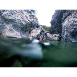
So this review is more specifically for the hiking trails "Partington Cove Trail" and "Tanbark Trail and Tin House". I did some research ahead of time to get the information on where the trials were. Highly recommend printing anything out ahead of time or taking snap shots, there is literally NO reception in the area. The trails are don't really have anything labeling them until your literally walking to it. If you use your Maps on your phone ahead of time even with the lost reception you'll be able to find it. Starting with Partington Cove Trail. The trail is rather short, took about 50 minutes to go down and back. It's not very difficult and offers a great view at the end. Going through the tunnel was cool and came out to a nice looking cove that has a river running directly to the ocean. If you backtrack and go to the beach it's also worth the walk through the bushes and plants along the trail. There are no signs coming up to where you can park so keep your eyes open, you park on either side of the hwy 1 and walk to the start where a gate is, walk around it. Def worth the hike. The Tanbark Trail and Tin House. So the Big Sur website shows that the trail is open only partway, from the Fire Road on Hwy 1 up to the Tin House and bSome websites are saying the trail is closed completely. We found the entrance via the Fire Road on Hwy 1, you can park at the Vista Point across from the entrance, not directly but close. If you parked at the Partington Cove parking you'd have to walk about 10 minutes along Hwy 1 to get to it (don't recommend as not much space with all the cars). You can see right away that the trail is not used much anymore, maybe due to the confusion of it being partly closed. Either way we started and going this way you are going up an incline immediately, rather tiring. The trail is still visible for the most part but is overgrown. We hiked about 2 hours in and weren't sure if it was the right trail as there are no markers, I later found out it was the correct trail. The views of the coast are amazing and you can see for miles. After the 2 hrs and unsure if we were on the right trail we decided to turn back, did not make it to the Tin House unfortunately :(. The hike down was way easier and once you get down to the trees again a lot cooler. Knowing what I know now I would have hiked all the way, but aside from the ocean views there isn't too much to look at on the way. Would rate 3 stars. I included pictures to help anyone who wants to try.

Mcway falls is beautiful something out of a story or a movie. So beautiful. Key things to note if you want to go - See if the trail is open. ( it wasn't but they instructed how to view the falls from the roadway) still beautiful. We did not have ANY RECEPTION after point lobos park traveling south on pch to Bixby bridge to the Julia phifer burns park which is where the mcway falls are. Roughly an hour drive depending on variables on the road. MAKE SURE YOU HAVE A FULL TANK OF GAS MORE ROUGHLY OVER 150 miles if you are going from Carmel. We had to get a couple gallons of gas in Big Sur and it was not cheap, almost double a regular gas price. All in all good trip! read more


Came here to use the bathrooms and go to Mcway Falls. First off bathrooms here are CLEAN. All the state parks in Big Sur seem to have very clean bathrooms. They didn't have an attendant on duty do we dropped a $10 bill for the park pass. Nice views, short walk. read more


Friend wanted to see McWay Falls so we went Sat 6/17/23. It's over 2.5hrs to get there from Fremont. Entrances fee $10 or get CA public library state park pass, limited free parking on Hwy 1 if u want to walk-in. They have flushed toilets & sink but only 4, and only 3 were working when u went. Follow signs to McWay Falls, only 10min hike down the stairs, go through tunnel and turn right. Beautiful waterfall, can't go down to the beach, just see it from trail Worth a visit. read more


We had to see McWay Falls while driving the PCH! It's such a short and easy walk to the viewpoint from the parking lot, anyone can do it. (Note: there are a couple short stairs at the very beginning) I think it took us 6 minutes from the parking lot. She's a thing of beauty! read more

1 year ago
Breathtaking views! Some of the trails are still closed due to the 2020 Doran fire. We were able to hike the following: - McWay falls: Easy, flat trail (about a half mile there and back). Best seen in the afternoon so the shade isn't covering the falls. Some of the trail is fenced off so you can't go as far as you used to. - Partington cove: Gravel trail, mostly downhill and then uphill (about a mile total). There's a cute bridge that takes you through some Redwoods and then a cool tunnel before you arrive at the cove. Watch out for the poison oak! $10 for a day pass will get you into all the state parks. Both must do's at JPBSP! read more


6 years ago
We were lucky that this park was open during a weekend of park and beach closures. The more popular trails were closed, but we were able to get out of the car and stretch our legs a bit while getting some fresh air and sunshine. We didn't hike too long as it was pretty warm out but we did enjoy a bit of the park and have a chance to see some of the redwoods. Sometimes I feel a bit spoiled, while on the trail I didn't want to take the experience for granted but we were recounting the numerous amount of insane incredibly beautiful hikes in different locations that we've been on and sometimes it really makes you aware to count some of the smallest simplest things as magical because you're not always going to top previous experiences elsewhere. It's not often I'm on a trail and thinking seen one forest seen them all, or seen one valley view seen them all but we really have just seen so many gorgeous forests, valleys, waterfalls around the world that I did feel a bit like this place came up short for me. Maybe I was in one of my moods, who knows. Maybe the trails that were closed were obviously some of the greater pay off views. A nice place to get outdoors but if the trails you're coming for are closed I'd definitely say hiking in Yosemite, Sequoia other spots, or some National Parks just take the cake here. We parked outside of the park where a bunch of cars were and walked in. If there is parking available inside it's $10 cash. read more


Pre-covid review: Finally getting around to jotting thoughts for my trip earlier this year to Big Sur in February. I'm not sure even if we were able to see the closed off areas when we were here this year would've made this place any better, but it definitely feels a bit overhyped as a few others have mentioned. We were also interested in checking out the Ewoldsen Trail when we were here, but learned it was closed off due to damage when we were here, so we were left with McWay Falls on our planned itinerary and I was looking forward to it as one of the highlights of my trip. It was a bit underwhelming, athough the ocean does look very nice and I felt like I had to check the place out since I've already made my trek out to Big Sur. It probably only took us 30mins for us to see McWay Falls from when we parked at the lot, walked over to the overlook area, took pictures, and came back. Most people opted to park on the street, which would've been a good option if we had known it wasn't going to take us long to only see McWay Falls. We were thinking of sparing ourselves from walking further and paying for the added safety and convenience of not parking next to the road, but it wasn't really that far and walking next to the road to and from your car is fine if you're safe about it. It wasn't a difficult trail and plenty of people made their way there, so come early if you want to take a photo with fewer people around. Not the most impressed with what we saw, but not too difficult to add as a stop if you're on the way to see other things in the area. read more

4 years ago
Was looking forward to this park, but out of the major 3 trails, only 1 was opened. It was the one towards the ocean but it was very short and the trail was not completed. For the time to get here and paid $10 cash for parking, this was not worth it. The waterfall was nice, but it's still quite a distance. read more


5 years ago
This vista point is absolutely gorgeous!! If we had more time I would sit on one of those stone fence post and do a bit of meditation. It really is so beautiful!! We had a very friendly blue jay hang around with us that day. Don't miss this scenic spot guys. It's worth a stop even if it's a short one. read more


Those views... they will simply take your breath away. Julia Pfeiffer Burns State Park is best known for its immaculate view of McWay Falls and Pfeiffer Beach. The waterfall trail is only a short .6 miles round trip and will provide you with a picturesque view of the falls and the California coastline. A multitude of hiking trails are available in the park, but the Waterfall Trail tends to be the most popular. People from all over come here just to take in the beautiful views of McWay Falls. There is a $10 entrance fee that will also allow you to visit any other state park within the same day. I would highly encourage anyone who is planning to come here to also visit Pfeiffer Big Sur State Park just 20 minutes down the road. You will really get the most out of the $10 fee this way. Some of the trails were closed to the public when I last visited the park about a month ago. Access to Pfeiffer Beach and McWay Falls are strictly prohibited and they will ticket you if you try to climb down from the waterfall trail. If you don't want to pay a hefty fine, don't even attempt it! This is a heavily trafficked park and although the parking is ample, it will get filled up during peak hours. The earlier you arrive here, the better. I didn't really explore too many of the trails since I mainly came to view McWay Falls. However, I did notice that the Canyon trail is equipped with some great inclines! They have a variety of different trails depending on your skill level. You'll be competing with other people to get that perfect picture of McWay Falls, so just be patient and wait your turn because it's worth it. It's a great park to visit if you're looking for draw dropping views and great hiking trails. read more


8 years ago
This is the place to get the standard picture of the McWay Falls on the beach & coastline. Heads up that it's a rather small waterfall whose trickle gets thinner each year (or so it seems). In order to get to the perimeter walk to see the waterfall, you need to first enter the Julia Pfeiffer Burns State Park and then take an immediate right once you see steps descending downwards. Walk a bit further and you'll go through an underground tunnel before emerging on the other side. From there, you can take a left to go see a small waterwheel (it's just a small hut at the end of the trail) or take a right to get closer to the falls. During my previous trips here, all the various trails were fabulous and relatively shady. There are some saddleback sections where you weave back and forth to get up the hill, so it can get tiring. As of August 2018, the right end of the McWay Falls walkway is closed to the public due to potential rockfall dangers. So do your best to get a good view in the space before the fence. The only trail open is a partial one that heads towards a larger falls and Tin House trail along the coast. You aren't able to get very far though, since the path isn't clear. Once you see the sign that the trail is closed on the left of a small creek crossing, just stop. They didn't really place the sign well to indicate that the trail is closed. So just know to turn around once you get to the roped up incline that begins the ascent up a saddleback ridge. Happy hiking! read more


This park is absolutely beautiful! The waterfall is iconic. The parking lot is small and there are usually crowds so keep that in mind when visiting. The Eastern side of the park remains closed at the time due to fires and floods in the area. read more

"Big Sur is the California that men dreamed of years ago, this is the Pacific that Balboa looked at from the Peak of Darien, this is the face of the earth as the Creator intended it to look" -- Henry Miller How have I missed reviewing this park? Obviously I have posted a few photos ;-) You know this park because of the lookout to McWay Falls. But the reason it gets 5 stars is not just for that iconic view, but for the inland trail that takes up to a waterfall, through a redwood forest and then to on top of the hills with a magnificent view of the Big Sur coast. It's rather silly frankly to pay $10 just to see the falls...there are a billion photos online you can see it for free. Spend more than just 10 minutes here. Walk along side the creek, take your time going up through the forest...spend a couple of hours in this wondrous forest rather than just check off a box of your Big Sur list. You really haven't explored Big Sur until you've hiked it for hours over multiple days and even through multiple hours. The inland hike here is less than 5 miles, follow the Ewoldsen Trail most of the time and it will loop back. You will thank me later if you do it...the photos don't lie ;-) read more


So this review is more specifically for the hiking trails "Partington Cove Trail" and "Tanbark Trail and Tin House". I did some research ahead of time to get the information on where the trials were. Highly recommend printing anything out ahead of time or taking snap shots, there is literally NO reception in the area. The trails are don't really have anything labeling them until your literally walking to it. If you use your Maps on your phone ahead of time even with the lost reception you'll be able to find it. Starting with Partington Cove Trail. The trail is rather short, took about 50 minutes to go down and back. It's not very difficult and offers a great view at the end. Going through the tunnel was cool and came out to a nice looking cove that has a river running directly to the ocean. If you backtrack and go to the beach it's also worth the walk through the bushes and plants along the trail. There are no signs coming up to where you can park so keep your eyes open, you park on either side of the hwy 1 and walk to the start where a gate is, walk around it. Def worth the hike. The Tanbark Trail and Tin House. So the Big Sur website shows that the trail is open only partway, from the Fire Road on Hwy 1 up to the Tin House and bSome websites are saying the trail is closed completely. We found the entrance via the Fire Road on Hwy 1, you can park at the Vista Point across from the entrance, not directly but close. If you parked at the Partington Cove parking you'd have to walk about 10 minutes along Hwy 1 to get to it (don't recommend as not much space with all the cars). You can see right away that the trail is not used much anymore, maybe due to the confusion of it being partly closed. Either way we started and going this way you are going up an incline immediately, rather tiring. The trail is still visible for the most part but is overgrown. We hiked about 2 hours in and weren't sure if it was the right trail as there are no markers, I later found out it was the correct trail. The views of the coast are amazing and you can see for miles. After the 2 hrs and unsure if we were on the right trail we decided to turn back, did not make it to the Tin House unfortunately :(. The hike down was way easier and once you get down to the trees again a lot cooler. Knowing what I know now I would have hiked all the way, but aside from the ocean views there isn't too much to look at on the way. Would rate 3 stars. I included pictures to help anyone who wants to try. read more


6 years ago
We visited the big Sur area August 2020 during the covid restrictions so I thought I would post a review so you know what's up with this park. It's closed. You can park along the 1 highway and take pictures of Mcway falls and you can even climb over a fence and take a dirt trail down when a ranger is not looking but you never get all the way down to the sand. The dirt trail is an overlook trail that is def pretty but if you are thinking you'll touch sea water good luck. They really need a better setup because it's incredibly sketchy walking along the highway and they need to open the beach so you can go down and enjoy it. Beautiful spot though. read more

--McWay falls review only -- Everyone on Instagram takes pictures of this beach but I didn't think it was anything special. I wish yelp or people I knew in real life kept it real and told me this place is a tourist trap :P :P (I'm joking btw :P) The waterfall is about 5 mins walk from the parking lot (you can practically see it off the road). How to get the waterfall - --To pay the $10 parking - Arrive at Julia Pfeiffer state park. Pay the $10 parking. Follow the signs to get to the waterfall (it literally takes 2 mins). The waterfall is nothing great - you are so far from it you can barely see anything. Note - this parking allows you to go to other state parks, so if you have those planned, paying to park might be worth it. --To park for free - Arrive at Julia Pfeiffer state park. Now you have a bearing where it is, exit the park and make a left, along the road you'll see a hiking path (you'll see steps towards the ocean). It's literally 15-20 paces outside the entrance to the state park. Try to find parking. Follow the steps which I told you about. 2 mins, you are at the falls. I'm glad I saw it to complain about how overhyped it was :P :P :P (again, joking) read more

We stopped in this park on our way through Big Sur. On the entering the park, we were greeted by a flock of stellar jays residing in a tree adjacent to the parking lot that were begging for food. We took the Overlook trail that led us under Highway 1 to a point high on a bluff with a magical view of the McWay Falls that tumble down some 80 feet onto a pristine beach off a picture perfect cove. This proved to be one of the highlights of recent vacation. read more


5 years ago
A very quick walk from the lot to this beautiful view. Worth checking out for sure however not a lot more to offer since the trails have pretty severe damage from the fires. read more

Beautiful park! We did not get to explore as much as we hoped but we got a couple good hours in. The redwoods are huge, I had no idea they could be that big. We had a blast and will definitely be back if we're in the area again. read more

I visited the Julia Pfeiffer Burns State Park on Friday for a quick day/photo trip. It was about 30-35 miles south of Carmel which took about 45 minutes to get to because of the windy roads. The parking is $10/day but make sure you bring exact change because there is no attendant on site. At the entrance there is a sign to pick up a small envelope to deposit your money...you then rip off the attache receipt and place it on your dash. They say a ranger will verify that you've paid or will issue you a citation. Unfortunately, I only had a $20 on me so that's how much parking cost me. It's ok...I don't mind supporting beautiful parks. There is a restroom at the entrance too which made it convenient after a long drive. The waterfall was a short 5 minute hike/walk away from the parking lot. It was gorgeous! I uploaded a few pics. There is A LOT of poison oak so be careful and stay on the trail. I wore long pants just in case. There are a few picnic tables in the parking area if you brought your own lunch. The blue jays will hover and flock to you though! Unfortunately, I didn't have time to hike the other trails but I'm sure the park was nice. I'm not sure if I'd go back though...Point Lobos is a few miles outside of Carmel and is easier to get to. I did enjoy stopping along highway 1 to take pics... The 45 min drive along highway 1 was relaxing though... read more


SUPER AWESOME!!! We got a campsite right above the McWay Fall. Great view...and nice to sleep with music of waves. It was great to see the ocean in evening, early morning, and the daytime. It was different. We also hiked to the Tin house on the top of the hill from the campsite, out and back 7.5 miles 1900feet elevation gain. Good workout, specutacular view as well. read more


18 years ago
Stunningly picturesque, tranquil, scenic food for your sore eyes which has been staring at a computer screen at work all week long . . . Upon entering State Park, please pay for parking IMMEDIATELY in front of bathrooms because Ranger Rick just loves to dole out parking fines! Also, please veer right for more parking to the right side of road past bathrooms because the circular driveway on the left side of the road only has a few parking spaces. The disabled wheel chair ramp and water fountain is on the right side next to parking lot. Just take a peek at MY pics I took of this gorgeous State Park! I went hiking through the tunnel and took a lot of beautiful pics of this State Park. Awesome place spending the day hiking and picnicking with your hunny . . . O=:-x It would be such a blissful, romantic getaway for you and your hunny if you would go to www.reserveamerica.com and camp at either Big Sur Campground or Limekiln State Park way down Highway 1 heading towards San Simeon . . . you know-the Hearst Fandamily's Estate! O=;-) Hint: On the way to San Simeon, please stop by Jade Cove before 1 PM and find some real JADE for your hunny. When you find some cool, jade rocks for your hunny, take the rocks to a gemologist jewelry artist, make the jade rocks into a nice jade ring, bracelet, and pendant! Your hunny will love you forever! read more


Sleeping under California redwoods, roasting marshmallows and driving the California coast at 7 AM just for THIS view = my whole life made. I've literally dreamt of driving up HWY 1 since I was a teenager. To finally make it to McWay Falls, a place I'd stumbled upon on Instagram just a few years earlier was truly a dream. It's about a 15-minute drive from 'Big Sur Campground and Cabins' where I was staying. The drive is stunning so time felt infinite. You can't visit Big Sur without checking out the waterfall. My only wish is that I could get closer. There's something about finally making it to a place you'd never thought you'd see. Travel has been just that for me - dreams turned to realities. Big Sur, I'll be back! Keep up with my food & travel adventures - https://www.instagram.com/briyoumetravel/ youmelunch.com #YouMeTravel read more

McWay Falls Location: You will see the Julia Burns main entrance on the east side of HWY 1. You can park inside and supposedly pay although we couldn't figure out who to pay who went in so didn't have to pay. Follow the Waterfall Overlook Trail. You can also park on both sides of HWY 1 outside of the main entrance. There is a path from west side of the road that leads down to the trail. Short walk. GORGEOUS VIEW!!! The trail ends at an old ruin of a house that was there before. I'd imagine this place is great for sunsets. The beach and waterfall is not open to the public. They have signs stating that many people have had to be rescued from here. Partington Point/Cove- 2 miles north of this trail is another trail that is a little longer of a hike, but also beautiful. read more


Feel like I can't give this an adequate review because when we came by everything was closed due to severe storm damage, but sounds like the closures will be around for a while so it is something to take into account. You are able to see the McWay Falls from the street, but the park itself is closed until further notice. read more

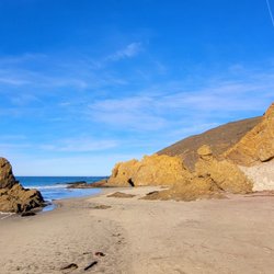
Easily missed off of highway 1 on your way to or from McWay Falls in Big Sur. Foot access at McWay falls is not allowed however at this beach you can and if you're lucky to see the sunset, during the winter solstice is quite an impressive light show known as the Keyhole Arch at Big Sur. I recommend you go online and look up photos of what the keyhole looks like by professional photographers. read more

Julia Pfeiffer Burns State Park is truly a place you could go to again and again and never get tired of the view. We picked up some sandwiches at the Big Sur Bakery's general store and ate them overlooking a spectacular view. Talk about Dinner Theater! There's a nice Redwoods trail that we didn't do this time but we took the short, easy Lookout trail to see McWay Falls and the Gorgeous piece of the Pacific Coast. Utterly mesmerizing! As a note, this time we discovered that there are steps to access the lookout point from the other side of the highway, so if you happen to snag a parking spot you can get down from there for free. read more


7 years ago
OK, so one star for the fact that you can't take a dog there. As we pulled in there was a picture of a dog and a line drawn through it. Not the usual sign where the indication is no dogs off leash. We always have our doggie with us when we go to the coast, so I guess I'll not see the park from the highway side of the road. But...five stars all day long for the view on the other side of the road, right at the park's entrance. After we turned around we decided to see what all those cars were pulled off the road on the ocean side for. Score! And I mean score! The most breathtaking view of a cliff with a waterfall, a little lagoon looking area and the big beautiful Pacific Ocean! It was the highlight of my day! It's called McWay Falls and the pic I took is worthy of a calendar page. Definitely worth the stop just to take the waterfall in. If you're driving south on the 1, pull off to the right just as you round a curve where the park entrance is. read more

10 years ago
When planning our trip down to SLO (San Luis Obispo for folks who don't know) I wanted to take advantage of being further south to do a nice little hike in a spot where it wouldn't be fully exposed in the sun, had about at least a 4 mile trail, and not too strenuous. In my search, I found that Julia Pfeiffer Burns State Park would be the spot and although we were really huffing it in the first 2.5 miles, it was worth it and quite a nice trek in the woods and fields. L O C A T I O N A bit further south from Big Sur and an hour-ish north of San Simeon, Julia Pfeiffer Burns State Park is located off of Highway 1. P A R K I N G It gets busy here, so we came on a Sunday morning around 11am and the parking lot was already full, though we weren't planning on paying the $10. We were lucky enough to get a parking spot off of Highway 1. Just make sure you're not over the white line and well behind it to not get ticketed. South bound had a few more spots that were shaded by the trees. T R A I L S There are a few trails here, one that's short and gets to the McWay Falls, another is the Canyon Trail which joins to Ewoldsen Trail (Which is a loop) and you can shoot off of that trail to get to the Water Trail as well as the Overlook Trail. There are a few more trails to the south which I didn't get a chance to look at but we did do the Ewoldsen Loop. There's a nice creek that you walk along when you're going up to Ewoldsen. It is a fairly gradual incline with some heinous steep sections so, it's definitely not for the faint of heart. Though it's very doable especially if you take some breaks and take in the view of the redwoods and nice shaded spots to take a break. There are portions of the trail that are not covered which if you do take the left at the fork, you won't be happy going up on when it's a sunny day. So make sure you take the right side as there's much more shade when you're trekking up. There's an overlook which you might feel like torture since it's more incline, but it'll be a nice little resting spot with a great view. By going counter clockwise, you'll be able to enjoy ocean views on your way down. O V E R A L L I enjoyed the trail we went on and I would definitely come back again if we were in the area. There's a restroom at the main parking area but that's pretty much it so make sure you take advantage of it. Also pre load your phone with maps and such as there is absolutely no phone reception out there. But it's definitely a great place to just enjoy nature and unplug from the world. read more


11 years ago
The high cost of anything and literally everything over at Big Sur may be enough to deter your CHEAP A$$ away. But if you are willing to overlook all that and need one excuse to be in Big Sur, spend the gas and time driving, and get yo butt tocks down here to Julia Pfeiffer Burns State Park. It will take you a good 30++ mins to trek down the long and winding road of Highway 1 along the coast from Carmel, cruisin anywhere from 30 to 40 mph, just to get here. But trust me it is well worth it. When there is no one at the toll booth (which appears to be usually the case), parking is on the honor self system, or self registration. I can't remember if it was $8 or not, as staying at the Big Sur Lodge included a complementary day pass to 5 nearby state parks. A tip, get here early. The parking lot can only hold 12 cars, and it fills up fast. There are two must-see trails to hike here. One of them is the Ewoldsen trail which I did not have time for. The McWay Falls is the other you do not want to miss. It is an easy 0.64 miles and all straight road. The entrance is right across from the restrooms, with a sign that says "Overlook 1/4 mi, Waterfall Trail, Pelton Wheel". Follow the path toward the waterfall trail, and be prepared to marvel at nature at its most stark naked and raw form. Don't get too trigger happy with your camera without taking a deep breath and taking a good moment to absorb the scenery that even the best pictures won't capture. Oh yeah, this stuff called Poison Oak. It's effin everywhere I tell ya. Even if you stay within the trail path and despite warning signs, it is almost unavoidable. You will start seeing them on the mountain side and the cliff side once you pass the tunnel. You just have to be well coordinated and not bump into these guys at all costs. http://www.yelp.com/biz_photos/GTBLDnOI81M7WJHyHy7voQ?select=AwOdrE6ucBMpXnt_jEApdw Hairy and scary stuff, enough to make one's crotch and ass itch, scratch & burn like mad just looking at pictures (imagine what that shizzle will do if you get in touch with it). Keep going for a bit, and you will get a brilliant view of the McWay Falls & Beach. It is completely off limits going down there, so just enjoy the view from where you are. At the end of the trail is a nice lookout point with two benches, and a breathtaking view of another coastline. If you are lucky you might see a rare local blue bird or two. http://www.yelp.com/biz_photos/GTBLDnOI81M7WJHyHy7voQ?select=RuhIwR6i33q3PaUK7rjM4w This guy was less than 2 feet away from me. I guess he was lookin for food, like some tourist's sandwich :-) read more


What should I say about this place? Phenomenal? Beautiful? This place was so amazing on both levels. Me and my college buddies came up here via Highway 1 on Spring Break and camped north of the McWay Falls some 20 minutes up. It was March-April, and it was actually rather easy finding street parking at 11 am here on Highway 1. Seeing the McWay Falls was the easy part; It's actually wheelchair accessible from the parking lot, and the walk from highway 1 to the Falls viewpoint is about 5 minutes. But this can wait. The best part of this wasn't the falls though. It was the Ewoldsen Trail loop that was more or less a 3 hour brisk walk through deep Redwood forests, wonderful looking rock structures, grassy hills, and ocean views. Note that this is NOT wheelchair accessible, but the entire trail is marked and unpaved. I would recommend walking UP the trail loop FIRST since it'll be a nice breather to see the falls when you get back. Tips for Hiking the Canyon/Ewoldsen Trail: 1. Bring some water for this walk - it's quite a walk and I wouldn't go without it. 2. When you see the trail, go up and back down Canyon, then turn right into Ewoldsen Trail. 3. When you get to the loop, I think there is a bridge. Take the RIGHT so that you're going counterclockwise on the Ewoldsen Loop. This is honestly the better way, since you'll be facing a gorgeous ocean view WHILE you're walking down on the way back. The right side of the loop is steep uphills with heavy forests, while the left side has some grassy hills and clearings. 4. Watch out for bees. There were some bees on the right side of the loop. Keep that in mind. 5. The hike is moderately steep, meaning there's no need to get on your hands to climb. Just steep for your legs. 6. Bring sunscreen. Once you get up to the upper reaches or the left side of the loop, you'll be pretty exposed at times to the sun. The right side is far shadier. 7. Once you get down, check out the falls for some nice relief. 8. Check out my photos for the order which our party travelled! read more


 - Parks Near Me - Big Sur, California")


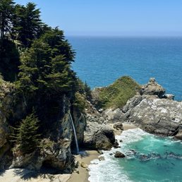
McWay Falls - http://www.yelp.com/biz_photos/julia-pfeiffer-burns-state-park-big-sur?select=mbLYuFfYZkVwup4QcLbVmA#mbLYuFfYZkVwup4QcLbVmA What: - Hiking - McWay Falls More Info: - $10/car parking fee inside the state park - Free parking outside the park Ever seen a waterfall that flows directly into the ocean? In reality, there are not too many of such falls. The McWay Falls at Julia Pfieffer State Park is the first that I have seen. The McWay Creek flows over an 80 feet cliff directly into the sand beach that connects with the Pacific ocean. We took a day trip to Big Sur on a Saturday and stopped at several places along the CA1 coastline, Carmel State Beach, Garrapata State Beach, Bixby Creek Bridge, to name a few. If there were any arbitrary turnouts offering a bella vista, then yes, we did stop at those spots as well. Overlook Falls Trail Length: 0.6 miles; Elevation: Insignificant; Time: 15min; Difficulty: Easy Parking is available inside the Julia Pfieffer State Park for a $10 parking fee. There is also free parking on CA-1 just outside the Julia Pfieffer State Park. Caution: If you park on CA-1, you will need to cross the road to take the trail to the McWay Falls and cars normally speed here. Once you cross the road, a distinct pathway and a fleet of stairs leads one to the McWay Falls. If you park inside the park, a tunnel that goes underneath the CA-1 safely connects you with the trail leading to the falls. There is a slew of hiking trails inside Julia Pfieffer State Park, but I have not taken any of them by far. I have only taken the short trail to the McWay Falls. Overlook Trail to McWay Falls - http://www.yelp.com/biz_photos/julia-pfeiffer-burns-state-park-big-sur?select=mbLYuFfYZkVwup4QcLbVmA#F8YXTzczUN_7l9mMcDmyUQ As you walk on the trail, when you are half-way to the trail end, you will see the beautiful McFalls falling over an 80 feet cliff into the sandy beach that connects to the ocean. Apparently, ages ago, the water fell directly into the ocean, but due to landslides and erosions, it now falls into the beach. There is no definite path that takes one to the base of the falls, but we have noticed people down there. Would I recommend? Definitely no! It is illegal and perilous to navigate the steep cliffs to get down to the falls. There are a few adventures in life that are not worth the risk and this is one of those! View of McWay Falls from the trail - http://www.yelp.com/biz_photos/julia-pfeiffer-burns-state-park-big-sur?select=mbLYuFfYZkVwup4QcLbVmA#7SxUq-r8o7uCro9GoV2FFA I always want to hike one of the trails in the Julia Pfieffer State Park, but by the time I start from San Jose, stop at several places along the CA1 coastline and reach this place, I am dog-tired. The trails are certainly worthwhile exploring. Tips: - Layered clothing is recommended - Free street parking just outside the park read more


12 years ago
Scenery: Ocean, Waterfall, Beach Difficulty: Easy Distance: .64 miles Elevation Gain: Pretty Level Duration: Route Type: In and Out Good for Kids: Yes Strollers: Yes Bikes: Pets: Restroom: Yes, in the parking lot Fees: Parking Lot $10 , Bus Parking (10-24 passengers) $50 On the side of the road, FREE! There are only 2 tidefalls in California, Alamere and McFalls. Last month, hubby and I hiked up 4.2 miles one way to see Alamere Falls. This past weekend we hiked a mere .64 miles round way trip to see McFalls. OVERLOOK WATERFALL TRAIL The parking lot was full, so we parked on the side of the road and made our way to the bathroom. Across the way from the bathroom, you will see the start of the Overlook Waterfall Trail. It's a very EASY and well maintained trail. First, go down the wooden steps, continue on the Overlook Waterfall Trail, and then through a tunnel. You will then see views of the ocean, make a right and continue on the trail. Soon, you will see the breathtaking views of the waterfall. It was pretty congested when we went, however, there are lots of places on the trail to take your photos. In addition, there are lots of benches throughout the trail too. If you keep walking up the trail, you will end up where the "Waterfall House" used to be. There are also informational reads on Julia Pfeiffer & Helen Brown, the house, and the landslide that happened on 1983. It was interesting to read that before the landslide, the waterfall used to fall directly into the ocean, now they fall on the sandy beach. Here, you will also have lots of photo opportunities. This is a great place to visit, especially since tidefalls are rare and only two in California. I definitely urge you to see McFalls for yourself. I was mesmerized by it's attraction. Looking out at the deep blue ocean, the cove, the waterfall, the beach, I stood there, numbed by it's beauty. The sight of it all is a photographers dream, a picture perfect photo. FYI It's illegal to climb anywhere in the area, especially down to the beach. read more
 - Parks Near Me - Big Sur, California")
 - Parks Near Me - Big Sur, California")
 - Parks Near Me - Big Sur, California")
 - Parks Near Me - Big Sur, California")
 - Parks Near Me - Big Sur, California")
 - Parks Near Me - Big Sur, California")
 - Parks Near Me - Big Sur, California")
 - Parks Near Me - Big Sur, California")
 - Parks Near Me - Big Sur, California")
 - Parks Near Me - Big Sur, California")
10 years ago
I came here on a Sunday afternoon just to do a quick stop for the waterfall trail/view of McWay Falls. It was very crowded and parking was full in the park ($10). There was a line of cars waiting, as well as a line of cars parked along highway 1. Be careful of parking along Highway 1! Make sure it is designated for parking! We parked directly outside the park on the right side, before the Julia Burns Pfeiffer State Park sign. Luckily, we only spent about 30 minutes inside the park because when we returned to our car, tickets were being issued to cars parked there. If you park there, passengers on the right side of the car will not be able to get out. That's where you shouldn't park. The waterfall trail was very short. Be sure to go all the way to the end and not just stop in the middle to take pictures. It gets better towards the end. It was about a 10-minute leisurely walk each way. There are so many other trails; I would suggest spending more time there and will do the same on my next road trip. read more


Page 1 of 7
More info about Julia Pfeiffer Burns State Park
52801 CA-1
Big Sur, CA 93920
Directions
(831) 667-1112
Call Now
Visit Website
https://www.parks.ca.gov/?page_id=578
Hours
Indoor Amenities
Outdoor Amenities
Ask the Community - Julia Pfeiffer Burns State Park
Are dogs alllowed here?
Review Highlights - Julia Pfeiffer Burns State Park
You might also consider


Why does Yelp recommend reviews?
16 reviews that are not currently recommended
The reviews below are not factored into the business's overall star rating.
18 years ago
16 years ago
8 years ago
11 years ago
11 years ago
12 years ago
12 years ago
14 years ago
11 years ago
17 years ago
12 years ago
13 years ago
11 years ago
Julia Pfeiffer Burns State Park - parks - Updated June 2026
Best of Big Sur
People found Julia Pfeiffer Burns State Park by searching for…
Browse Nearby
BEST of Big Sur, California Restaurants near Julia Pfeiffer Burns State Park
BEST of Big Sur, California Coffee near Julia Pfeiffer Burns State Park
BEST of Big Sur, California Beaches near Julia Pfeiffer Burns State Park
BEST of Big Sur, California Campgrounds near Julia Pfeiffer Burns State Park
BEST of Big Sur, California Breakfast near Julia Pfeiffer Burns State Park
Browse Brands
Browse Articles
People who viewed Julia Pfeiffer Burns State Park also viewed
Pfeiffer Big Sur State Park
405 reviews
Calla Lily Valley
8 reviews
Point Lobos State Natural Reserve
1132 reviews
Point Sur State Historic Park
34 reviews
Mission Trail Park
28 reviews
Partington Cove
54 reviews
Ewoldsen Trail
29 reviews
Sand Dollar Beach
30 reviews
Jade Cove Beach
27 reviews
Salmon Creek Falls
14 reviews