Los Osos Oaks State Reserve Photos


You might also consider


More like Los Osos Oaks State Reserve
Recommended Reviews - Los Osos Oaks State Reserve
Start your review...


Reviews With Photos


We were the only ones on this trail. When we spoke to a local we were surprised that not everyone knew about this Reserve. The pathway is so green with tall overgrown oak trees. You can cover the entire place by walking on a flat path for 1 1/2 miles. This trail is perfect for beginners. There is poison oak throughout the hike so you'll want to stay on the path. Its a pretty shady trail since majority of the time your walking on a path that goes through large oak trees. The pathway looks so beautiful because its covered with fallen oak leaves. You can hear water from the creek while your on this trail. There is plenty of cemented parking lot right next to the trail. The trail is well marked. There is no restrooms.


Welcome to the Poison Oak Wilderness. Jk, because that's basically all of the Central Coast :P. Pros: - This is a super easy, small hike that is located off of Los Osos Valley Road. - There is lots of shade. - There is unique flora here that is DEF worth seeing. - Free, ample parking Cons: - PO Wilderness - Mosquito breeding ground near creek - Too small! This is so great that you want it to go on forever! - The paths are meandering and not clear, but you won't get lost. - You will hear the road for a good portion of the hike. Worth seeing...go check it out!


I am pretty lucky that I have relatives that live around here and when I saw a few Yelp friends review this place I was shocked I had never been here from all the years of traveling down Los Osos Valley Road. It's one of those places that is pretty hidden and unless you knew it existed you would probably just drive by. The map from Yelp is not very accurate so look for the entrance on Los Osos Valley road a mile or so past the Memorial Park it will be on your left. I happen to be with a small group of mushroom experts who were looking looking for mushroom called the Death Angel or also called Western North American Destroying Angel mushroom. The reason was that this mushroom was around quite a long time ago but then kind of disappeared. Recently a dog in Santa Barbara died from the mushroom and they have since been spotting these spreading throughout California. So the the goal was to see if they could find some of those guys in this forest which means that they are spreading up north. I happen to love the whole science of mushroom having read books like Mycelium Running so this was right up my ally. The idea that one mushroom can heal you while another put you down under in hours is pretty interesting but scary stuff. It didn't take all that long to find one of these poisonous guys and you would never know by the way it looked, a beautiful color of white. Just what you would think to dice up and toss into your favorite dishes..not!. So if you like foraging for mushrooms you might want to think twice. On to the trail itself what is cool about the trails here is they offer a variety of different things to see. There is some areas that are woody and cool while other areas have more sand and are hot. There are 3 different trails you can go on-- one goes right one goes left and one down the center. They all end up converging with each other at some point. They don't have any maps here even one to view at entrance so you will need to follow the signs that are posted. The problem is the signs are not very well laid out at all and it's pretty easy to get lost because in the back areas the signs end up leading you in a circular pattern instead of back to Los Osos Valley Road. Good news is when you get the residential housing you know you are at the end of the park in back so just head in the opposite direction. Also there is a mobile home park on the right so once you get to these areas you are at the end of the reserve and you know you will not get further lost. Also another way to find your way back is to listen for the cars on Los Osos Rd. Other than the poor directions it's has some nice trails with enchanted looking forests and wild animals running around in the non trailed areas. Lots of native California plants to view and it's pretty quiet in terms of seeing other hikers. I would give yourself a couple of hours to fully see the entire place, maybe longer if you get lost. It's amazing how many hidden trails we have in California that are to be found, and this one is a good one to check out.


Came here expecting to see just oak trees but ended up finding a variety of fungi in all shapes and colors. It was a gorgeous winter day as I was walking through the park I quickly stumbled upon a fresh foot print of a wildlife (see associated picture). I couldn't figure out whether it was a bear or a mountain lion but sent shivers through my spine. I was praying not to come face to face with whatever creature it might have been. The vast changes in scenery were quite breathtaking. So happy to have been here and would definitely return and hope to find something else unexpected.


Beware this beauty. We spent about a half hour exploring these trails. My husband had two ticks on him when we returned to the car. Just beware but enjoy


An unusual walk through the woods due to the unusual trees. It was a bit hard to find the entrance with our mapping app. We would have spent more time walking but it had rained and was muddy. It was definitely worth the stop after visiting Morro Bay.


Anyone that loves the outdoors and trees will love this little hiking area. It is not very big but it is very enjoyable. We managed to get 2 miles out of doing all of the trails. This was our first time here and it was a little intimidating not knowing what trail to take and then if we were going to find our way back. We started with the Chumash trail and it was not even listed on the map. The trails are merely a foot path and therefore is only good for those that can walk. No strollers would ever make it. The trail would be muddy after a rain. The rain is making the grass grow on the forest floor and at some points it was difficult to determine where the trail actually was. By others walking before us, we could see the trodden grass. At one point we completely lost the trail and felt like we were off roading before we found it again. We loved all of the crooked branch trees and it makes for some really beautiful pictures along the trail. We did not see any of the critters that were listed in the brochure. It would be wise to wear old shoes especially if it has recently rained. Keep your children in sight at all times because there are so many areas for them to take off in and you will not be able to see them. We will definitely go back again.
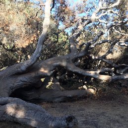

I love love love oak woodlands and if you want a qwik hike in a sanctuary of oaks and fresh air off and away from a busy road then go here. Also if you are with someone who doesn't like to hike, they will hike here and love it. What a treasure!! Lovely grand oaks
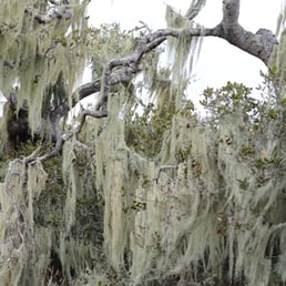

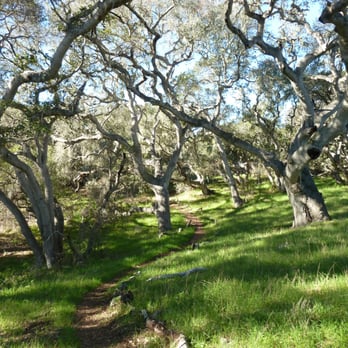
My enchanted forest!!! ...and you don't have to travel far to the Fairy Tale Land, the Los Osos Oaks State Reserve is located right off Los Osos Valley Rd. with a small parking lot fits maximum maybe 10 cars. Look at the trail map, you will get a brief idea. Even though some reviews stated trails are not well marked, it's in fact very simple and hard to get lost. There's no scale on the map, it's smaller than I had anticipated though. The whole loop (started from Loop trail, connected to Oak View Trail and back from Los Osos Creek Trail) took me about 35 mins despite I stopped here and there to take photos and just enjoying the fresh smell of the wood after the rain. The more deep into the wood, where the Loop trail and Oak View Trail connects, the 800 years old Costal live oaks made me feel like everything would come alive when the sun goes down...and I absolutely love my solitude. Once you are closer to the entrance, you will start hearing the cars driving by Los Osos Valley Road and you know you are heading the right direction. I wouldn't consider it's a workout but absolutely good for all hiking levels and a short escape from the people. Side note: Poison oaks are natural part of the area, however, it's winter I was pretty much covered. read more


Located near Montana De Oro, Los Osos State reserve is a great place to hike trails and just enjoy the outdoor Beaty that the Central California Coast offers. I absolutely love those twisted oaks, they are gorgeous. Also a great place for family pictures read more


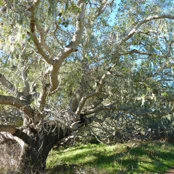
Local Eval.: Mysterious ancient surreal "Dali-like" twisted Oaks, almost drowning in huge beards composed of Usneoides, in a dreamy moist microclimate, punctuated by the distant noise. As with Dali's masterpiece of "The Persistence of Memory", the soothing, yet disturbing juxtaposition of the tortured twisted 800 year old Oaks covered with tons of ponderous Pseudo-moss is the stuff of surreal nightmares & fevered far future dreams....where ordinary man has long been forgotten. It reminds me of the imaginings of Robert Silverberg's in his best novel & my most treasure Sci-Fi book, titled, "The Son of Man". While the path seems straightforward at first, it is quite easy to wind up following dead end paths, which can be a bit fun, or not. Since the noise never really goes away, you can always head toward a direction where it gets louder. Since the trail map & trail heads all indicated loops, I picked the Chumash loop. While one can always backtrack, the far ends of the trails do not obviously interconnect, nor are labelled well, so I can see why people get lost. Fortunately, it is a rather small reserve, which is a mixed blessing. As you progress, you go through some interesting terrain changes...from sandy beach like brush to very moist Oak/Spanish Moss humid twisted tree dense surreal forrest. It is rather otherworldly and I have not seen anything quite like it before in my travels...so it is well worth a brief easy hike. The provided pamphlet is informative. BUT BEWARE OF SOME STEEP HIDDEN SUDDEN DROPS TO A CREEK BED! As many others have noted, it is a relatively unknown preserve, easy to pass by on the road unnoticed, & rather devoid of people. My wife became a bit scared when I reviewed some tips on what to do if we happened to encounter bigger mammals [which I doubt live here...but Los Osos means "Bears"]. The last thing one wants to do, is to run from either a Mountain Lion or a Bear. She was ultimately spooked by....wait for it...a human being! She was right....human beings are the most dangerous. She actually asked for me to buy her a Pepper Spray for the future. Other than two other humans [who looked a bit suspiciously paranoid and possibly equipped to camp there over-night], I only saw a small lizard, and did not notice any Poison Oak/Ivy, nor Stinging Nettle [which I had a horrid very painful run in with at Arroyo Grande's creek a few weeks back]. While I may have seen "Pele's Hair" [AKA invasive Spanish Moss in Hawaii] while hiking in Oahu's Tantalus forested area, I had never before seen, nor really appreciated, overwhelming volumes of "Moss". They are not a form of Lichen nor Moss, as others have noted, but are Usneoides, relatives to so-called "Air" plants, which get their nutrients from the air, and even leaching minerals from Oak trees. They may endanger trees not by feeding on them, but may break branches under their wet weight. Really amazing & surreal creations of evolution & well worth the short hike/diversion from more famous touristed areas nearby. According to Wikipedia: "...This plant's specific name Usneoides means "resembling Usnea", and it indeed superficially resembles its namesake Usnea, also known as beard lichen, but in fact Spanish moss is neither a moss nor a lichen. Instead, it is a flowering plant (angiosperm) in the family Bromeliaceae (the bromeliads) which grows hanging from tree branches in full sun through partial shade....Spanish-moss is an epiphyte which absorbs nutrients and water through its leaves from the air and rainfall. While it rarely kills the tree upon which it grows, it can occasionally become so thick that it shades the tree's leaves and lowers its growth rate....the plant seems to show a preference for growth on southern live oak (Quercus virginiana) and bald cypress (Taxodium distichum) because of these trees' high rates of foliar mineral leaching (calcium, magnesium, potassium, and phosphorus) providing an abundant supply of nutrients to the plant... Tillandsia is a genus of around 650 species of evergreen, perennial flowering plants in the family Bromeliaceae, native to the forests, mountains and deserts of northern Mexico and south-eastern United States, Mesoamerica and the Caribbean to mid Argentina. Their leaves, more or less silvery in color, are covered with specialized cells (trichomes) capable of rapidly absorbing water that gathers on them. They are also commonly known as airplants because of their natural propensity to cling wherever conditions permit: telephone wires, tree branches, barks, bare rocks, etc. Their light seeds and a silky parachute facilitate this spread. Most Tillandsia species are epiphytes - which translates to 'upon a plant'. Some are aerophytes, which have a minimal root system and grow on shifting desert soil. Due to the epiphytic way of life of the plants the peculiarity arises that these bulbs do not lie in the ground, but hang in the air on branches.". read more



8 years ago
We were the only ones on this trail. When we spoke to a local we were surprised that not everyone knew about this Reserve. The pathway is so green with tall overgrown oak trees. You can cover the entire place by walking on a flat path for 1 1/2 miles. This trail is perfect for beginners. There is poison oak throughout the hike so you'll want to stay on the path. Its a pretty shady trail since majority of the time your walking on a path that goes through large oak trees. The pathway looks so beautiful because its covered with fallen oak leaves. You can hear water from the creek while your on this trail. There is plenty of cemented parking lot right next to the trail. The trail is well marked. There is no restrooms. read more

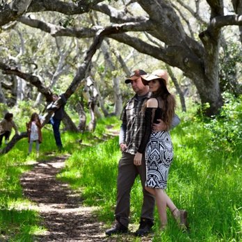


Welcome to the Poison Oak Wilderness. Jk, because that's basically all of the Central Coast :P. Pros: - This is a super easy, small hike that is located off of Los Osos Valley Road. - There is lots of shade. - There is unique flora here that is DEF worth seeing. - Free, ample parking Cons: - PO Wilderness - Mosquito breeding ground near creek - Too small! This is so great that you want it to go on forever! - The paths are meandering and not clear, but you won't get lost. - You will hear the road for a good portion of the hike. Worth seeing...go check it out! read more


5 years ago

8 years ago
I am pretty lucky that I have relatives that live around here and when I saw a few Yelp friends review this place I was shocked I had never been here from all the years of traveling down Los Osos Valley Road. It's one of those places that is pretty hidden and unless you knew it existed you would probably just drive by. The map from Yelp is not very accurate so look for the entrance on Los Osos Valley road a mile or so past the Memorial Park it will be on your left. I happen to be with a small group of mushroom experts who were looking looking for mushroom called the Death Angel or also called Western North American Destroying Angel mushroom. The reason was that this mushroom was around quite a long time ago but then kind of disappeared. Recently a dog in Santa Barbara died from the mushroom and they have since been spotting these spreading throughout California. So the the goal was to see if they could find some of those guys in this forest which means that they are spreading up north. I happen to love the whole science of mushroom having read books like Mycelium Running so this was right up my ally. The idea that one mushroom can heal you while another put you down under in hours is pretty interesting but scary stuff. It didn't take all that long to find one of these poisonous guys and you would never know by the way it looked, a beautiful color of white. Just what you would think to dice up and toss into your favorite dishes..not!. So if you like foraging for mushrooms you might want to think twice. On to the trail itself what is cool about the trails here is they offer a variety of different things to see. There is some areas that are woody and cool while other areas have more sand and are hot. There are 3 different trails you can go on-- one goes right one goes left and one down the center. They all end up converging with each other at some point. They don't have any maps here even one to view at entrance so you will need to follow the signs that are posted. The problem is the signs are not very well laid out at all and it's pretty easy to get lost because in the back areas the signs end up leading you in a circular pattern instead of back to Los Osos Valley Road. Good news is when you get the residential housing you know you are at the end of the park in back so just head in the opposite direction. Also there is a mobile home park on the right so once you get to these areas you are at the end of the reserve and you know you will not get further lost. Also another way to find your way back is to listen for the cars on Los Osos Rd. Other than the poor directions it's has some nice trails with enchanted looking forests and wild animals running around in the non trailed areas. Lots of native California plants to view and it's pretty quiet in terms of seeing other hikers. I would give yourself a couple of hours to fully see the entire place, maybe longer if you get lost. It's amazing how many hidden trails we have in California that are to be found, and this one is a good one to check out. read more






5 years ago

Came here expecting to see just oak trees but ended up finding a variety of fungi in all shapes and colors. It was a gorgeous winter day as I was walking through the park I quickly stumbled upon a fresh foot print of a wildlife (see associated picture). I couldn't figure out whether it was a bear or a mountain lion but sent shivers through my spine. I was praying not to come face to face with whatever creature it might have been. The vast changes in scenery were quite breathtaking. So happy to have been here and would definitely return and hope to find something else unexpected. read more




6 years ago

8 years ago
Beware this beauty. We spent about a half hour exploring these trails. My husband had two ticks on him when we returned to the car. Just beware but enjoy read more


6 years ago

An unusual walk through the woods due to the unusual trees. It was a bit hard to find the entrance with our mapping app. We would have spent more time walking but it had rained and was muddy. It was definitely worth the stop after visiting Morro Bay. read more


7 years ago
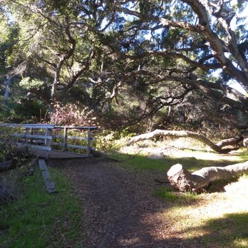
Anyone that loves the outdoors and trees will love this little hiking area. It is not very big but it is very enjoyable. We managed to get 2 miles out of doing all of the trails. This was our first time here and it was a little intimidating not knowing what trail to take and then if we were going to find our way back. We started with the Chumash trail and it was not even listed on the map. The trails are merely a foot path and therefore is only good for those that can walk. No strollers would ever make it. The trail would be muddy after a rain. The rain is making the grass grow on the forest floor and at some points it was difficult to determine where the trail actually was. By others walking before us, we could see the trodden grass. At one point we completely lost the trail and felt like we were off roading before we found it again. We loved all of the crooked branch trees and it makes for some really beautiful pictures along the trail. We did not see any of the critters that were listed in the brochure. It would be wise to wear old shoes especially if it has recently rained. Keep your children in sight at all times because there are so many areas for them to take off in and you will not be able to see them. We will definitely go back again. read more



11 years ago

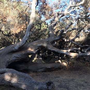
I love love love oak woodlands and if you want a qwik hike in a sanctuary of oaks and fresh air off and away from a busy road then go here. Also if you are with someone who doesn't like to hike, they will hike here and love it. What a treasure!! Lovely grand oaks read more
15 years ago
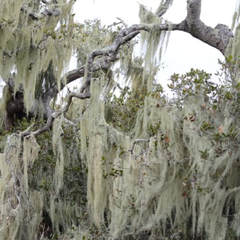
The Beau and I happened to stumble upon this magical forest on a recent trip to central California. This has got to be one of the most romantic and beautiful hikes I've been on - and I've been fortunate enough to hike in the rain forest! As soon as we stepped out of our vehicle we both felt like we were in a story book. This captivating location tells a dramatic story with every step. You are surrounded by stunning oak trees draped in a unique, seafoam colored lichen. The trees twist and turn from the earth in such harmonious ways. Fairy-like moths fluttered about, guiding us deeper and deeper into this enchanted forest while the crunch of the golden leaves beneath our feet offered a soothing soundtrack. We were in such awe throughout the hike, neither one of us did much talking and we paid no attention to where we were going! Yup, we got lost. After about 2 hours in, with sundown approaching, The Beau suggested we head back. We started making what we thought was the way back and ended up in an RV park!!! Since daylight was quickly fading we decided it best to walk through the RV park. We ended up knocking on someone's door who offered to take us back to our car - what a nice guy! He was also very familiar with the woods and admitted he sometimes gets lost in there! It was an unforgettable adventure which neither one of us will ever forget. You will get lost if you don't pay attention, but this is such a treasure it's totally worth it! read more


9 years ago
7 years ago

16 years ago
10 years ago

14 years ago
More info about Los Osos Oaks State Reserve
Ask the Community - Los Osos Oaks State Reserve
Review Highlights - Los Osos Oaks State Reserve
You might also consider































Why does Yelp recommend reviews?
1 review that is not currently recommended
The reviews below are not factored into the business's overall star rating.

9 years ago
Los Osos Oaks State Reserve - hiking - Updated August 2026
Best of Los Osos
People found Los Osos Oaks State Reserve by searching for…
Trending Searches in Los Osos, CA
Antiques near Los Osos Oaks State Reserve
Barbershop For Men near Los Osos Oaks State Reserve
Bike Shop near Los Osos Oaks State Reserve
Bird Sanctuary near Los Osos Oaks State Reserve
Cliff Jumping near Los Osos Oaks State Reserve
Consignment Shops near Los Osos Oaks State Reserve
Cruising Spots near Los Osos Oaks State Reserve
Dog Friendly Things To Do near Los Osos Oaks State Reserve
Ear Piercing near Los Osos Oaks State Reserve
Eyebrow Threading near Los Osos Oaks State Reserve
Flower Fields near Los Osos Oaks State Reserve
Kids Haircut near Los Osos Oaks State Reserve
Lakes near Los Osos Oaks State Reserve
Mini Golf near Los Osos Oaks State Reserve
Parks near Los Osos Oaks State Reserve
Pedicure near Los Osos Oaks State Reserve
Permanent Makeup near Los Osos Oaks State Reserve
Picnic Areas near Los Osos Oaks State Reserve
Preschools near Los Osos Oaks State Reserve
Public Golf Courses near Los Osos Oaks State Reserve
Public Pools near Los Osos Oaks State Reserve
Rock Quarry near Los Osos Oaks State Reserve
Scenic Night View near Los Osos Oaks State Reserve
Scenic Overlook near Los Osos Oaks State Reserve
Sunrise View near Los Osos Oaks State Reserve
Swimming Holes near Los Osos Oaks State Reserve
Trading Card Shops near Los Osos Oaks State Reserve
Used Furniture Stores near Los Osos Oaks State Reserve
Browse Articles
Browse Nearby
BEST of Los Osos, California Coffee near Los Osos Oaks State Reserve
BEST of Los Osos, California Restaurants near Los Osos Oaks State Reserve
BEST of Los Osos, California Things to Do near Los Osos Oaks State Reserve
BEST of Los Osos, California Parks near Los Osos Oaks State Reserve
BEST of Los Osos, California Walking Trails near Los Osos Oaks State Reserve
BEST of Los Osos, California Breakfast near Los Osos Oaks State Reserve
BEST of Los Osos, California Lodging near Los Osos Oaks State Reserve
BEST of Los Osos, California Campgrounds near Los Osos Oaks State Reserve
BEST of Los Osos, California Motel near Los Osos Oaks State Reserve
Browse Brands
Related Searches in Los Osos, CA
Affordable Canoe Rental Options in Los Osos, California
Affordable Kayak Rental Services in Los Osos, California
Best Dog Hiking Trails Around Los Osos, California
Best Fishing Locations and Guides in Los Osos, California
Best Places for Horseback Riding in Los Osos, California
Best Sightseeing Experiences Available in Los Osos, California
Best Waterfalls and Swimming Holes in Los Osos, California
Discover Dog Friendly Trails to Explore in Los Osos, California
Discover Easy Hiking Trails Near Los Osos, California
Discover Kid Friendly Hiking Trails in Los Osos, California
Discover Popular Bike Trails in Los Osos, California
Discover Scenic Mountain Bike Trails Near Los Osos, California
Discover a Hiking Trail in Los Osos, California
Discover the Best Night Hike Trails in Los Osos, California
Dog-Friendly Hikes With Dogs in Los Osos, California
Enjoy Camping Adventures Around Los Osos, California
Enjoy Exciting Mountain Biking Adventures in Los Osos, California
Enjoy Kayaking Adventures in Los Osos, California
Enjoy Off Leash Dog Hikes in Los Osos, California
Enjoy Tent Camping Spots Around Los Osos, California
Enjoy a Beautiful Waterfall Hike in Los Osos, California
Enjoy the Best Walking Trails in Los Osos, California
Explore Beautiful Parks and Green Spaces in Los Osos, California
Explore Easy Hikes Perfect for All in Los Osos, California
Explore Fun Activities to Do in Los Osos, California
Explore Popular Campgrounds Near Los Osos, California
Explore Popular State Park Destinations in Los Osos, California
Explore Top Dog Parks in Los Osos, California Near You
Explore the Best Beach Spots in Los Osos, California
Family Friendly Hiking With Kids in Los Osos, California
Find Fun Kids Activities Outdoor in Los Osos, California
Find Popular Ziplining Spots Around Los Osos, California
Find Top-Rated Waterfalls in Los Osos, California Now
Find the Best Playgrounds to Visit in Los Osos, California
Hiking Trails With Waterfalls in Los Osos, California
Off Leash Dog Hiking Trails in Los Osos, California
Picnic Areas With BBQ Pits Available in Los Osos, California
Popular Outdoor Activities to Try in Los Osos, California
Popular Picnic Spots to Visit in Los Osos, California
Safe and Fun Parks for Kids in Los Osos, California
Top Dog Friendly Things to Do in Los Osos, California
Top Hiking Trails to Explore in Los Osos, California
Top Playgrounds for Kids to Enjoy in Los Osos, California
Top Running Trails to Explore in Los Osos, California
Top Swimming Spots and Pools in Los Osos, California
Top Things to Do With Kids in Los Osos, California


