Mallory Cave Trail - NCAR Mesa Trail Photos


You might also consider
More like Mallory Cave Trail - NCAR Mesa Trail
Recommended Reviews - Mallory Cave Trail - NCAR Mesa Trail
Start your review...

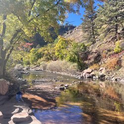
Reviews With Photos


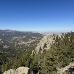
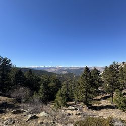
To climb this trail one must call upon their inner mountain goat. This is a steep, rocky, rough terrain but the views are phenomenal. From the NCAR building to the cave its about 2.7 miles and there is an elevation gain of around 850 ft. When I went the last portion of the trail and the cave were closed due to some bat disease. But this is a good trail overall. There is plenty of parking at the NCAR building parking lot. Make sure to wear study shoes, comfortable clothing and bring a couple of bottles of water per person. Total round trip hike time is around 1.5 to 2 hours depending on expertise and fitness level.


This is a 3 mile out-and-back moderate trail with great views. Plenty of parking and access to restrooms at NCAR. The cave is closed from April 1st to October 1st, but you can go further to the right on the climber trail which let you go further up to even more overlook points. read more

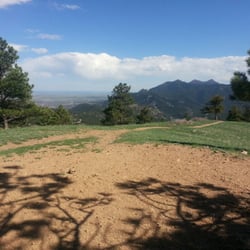
Those lucky locals get to hike these trails right next to town. There's free parking at NCAR and plenty of moderate trails to hike. The cave trail provides a decent amount of elevation gain and is doable for kids and also adults who want to escape the city. read more


5 years ago
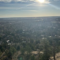
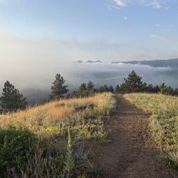
This is a hiking trail with beautiful view on the flatirons. There is a lot of parking available at NCAR. The trail head is on north side if the building. The trail is popular so don't expect to be alone. The views are stunning. read more

9 years ago
To climb this trail one must call upon their inner mountain goat. This is a steep, rocky, rough terrain but the views are phenomenal. From the NCAR building to the cave its about 2.7 miles and there is an elevation gain of around 850 ft. When I went the last portion of the trail and the cave were closed due to some bat disease. But this is a good trail overall. There is plenty of parking at the NCAR building parking lot. Make sure to wear study shoes, comfortable clothing and bring a couple of bottles of water per person. Total round trip hike time is around 1.5 to 2 hours depending on expertise and fitness level. read more


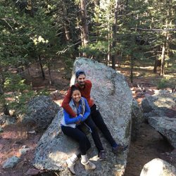
I absolutely loved the views and trail at NCAR. It's a pretty easy hike that allows you to soak in the beautiful views of Boulder. We didn't make it to the cave to see the bats but we did thoroughly enjoy the hike all the same. It was a bit muddy the day we went so I look forward to going again soon when the snow has totally melted. I appreciated that the trail was labeled very well, so that you won't get lost. We also noticed that it connects to Chautauqua park and felt like that would be very fun. The trail would be good for either running or walking. My friends and I love to spend quite a bit of time hiking and this is a new favorite. We will be back soon to enjoy this beautiful little hike. read more


14 years ago
More info about Mallory Cave Trail - NCAR Mesa Trail
Mallory Cave Trail
Boulder, CO 80305
Directions
Hours
Outdoor Amenities
Ask the Community - Mallory Cave Trail - NCAR Mesa Trail


Mallory Cave Trail - NCAR Mesa Trail - hiking - Updated July 2026
Best of Boulder
People found Mallory Cave Trail - NCAR Mesa Trail by searching for…
Trending Searches in Boulder, CO
Blueberry Picking near Mallory Cave Trail - NCAR Mesa Trail
Boat Tours near Mallory Cave Trail - NCAR Mesa Trail
Cliff Jumping near Mallory Cave Trail - NCAR Mesa Trail
Cruising Spots near Mallory Cave Trail - NCAR Mesa Trail
Day Trips near Mallory Cave Trail - NCAR Mesa Trail
Dog Friendly Trails near Mallory Cave Trail - NCAR Mesa Trail
Jet Ski Rental near Mallory Cave Trail - NCAR Mesa Trail
Kayak Rental near Mallory Cave Trail - NCAR Mesa Trail
Kids Activities Indoor near Mallory Cave Trail - NCAR Mesa Trail
Lakes & Ponds near Mallory Cave Trail - NCAR Mesa Trail
Off Road Trails near Mallory Cave Trail - NCAR Mesa Trail
Outdoor Activities near Mallory Cave Trail - NCAR Mesa Trail
Places To Swim near Mallory Cave Trail - NCAR Mesa Trail
Places To Walk Around near Mallory Cave Trail - NCAR Mesa Trail
Public Shower near Mallory Cave Trail - NCAR Mesa Trail
River Swimming near Mallory Cave Trail - NCAR Mesa Trail
River Tubing near Mallory Cave Trail - NCAR Mesa Trail
Rock Quarry near Mallory Cave Trail - NCAR Mesa Trail
Scenic Night View near Mallory Cave Trail - NCAR Mesa Trail
Scenic Overlook near Mallory Cave Trail - NCAR Mesa Trail
Soccer Store near Mallory Cave Trail - NCAR Mesa Trail
Sunrise View near Mallory Cave Trail - NCAR Mesa Trail
Swimming Holes near Mallory Cave Trail - NCAR Mesa Trail
Swimming Lakes near Mallory Cave Trail - NCAR Mesa Trail
U Pick Farms near Mallory Cave Trail - NCAR Mesa Trail
Watch Sunset near Mallory Cave Trail - NCAR Mesa Trail
Browse Articles
Browse Nearby
BEST of Boulder, Colorado Things to Do near Mallory Cave Trail - NCAR Mesa Trail
BEST of Boulder, Colorado Coffee near Mallory Cave Trail - NCAR Mesa Trail
BEST of Boulder, Colorado Restaurants near Mallory Cave Trail - NCAR Mesa Trail
BEST of Boulder, Colorado Parks near Mallory Cave Trail - NCAR Mesa Trail
BEST of Boulder, Colorado Breakfast near Mallory Cave Trail - NCAR Mesa Trail
BEST of Boulder, Colorado Playgrounds near Mallory Cave Trail - NCAR Mesa Trail
Browse Brands
Related Searches in Boulder, CO
Affordable Kayak Rental Services in Boulder, Colorado
Best Dog Hiking Trails Around Boulder, Colorado
Best Fishing Locations and Guides in Boulder, Colorado
Best Nature Trails for Hiking in Boulder, Colorado
Best Places for Horseback Riding in Boulder, Colorado
Best Sightseeing Experiences Available in Boulder, Colorado
Check Out Off Road Trails in Boulder, Colorado
Discover Dog Friendly Trails to Explore in Boulder, Colorado
Discover Kid Friendly Hiking Trails in Boulder, Colorado
Discover Popular Bike Trails in Boulder, Colorado
Discover Scenic Mountain Bike Trails Near Boulder, Colorado
Discover a Hiking Trail in Boulder, Colorado
Discover the Best Night Hike Trails in Boulder, Colorado
Dog-Friendly Hikes With Dogs in Boulder, Colorado
Enjoy Camping Adventures Around Boulder, Colorado
Enjoy Kayaking Adventures in Boulder, Colorado
Enjoy Off Leash Dog Hikes in Boulder, Colorado
Enjoy Tent Camping Spots Around Boulder, Colorado
Enjoy a Beautiful Waterfall Hike in Boulder, Colorado
Enjoy the Best Walking Trails in Boulder, Colorado
Experience Thrilling White Water Rafting in Boulder, Colorado
Explore Beautiful Parks and Green Spaces in Boulder, Colorado
Explore Easy Hikes Perfect for All in Boulder, Colorado
Explore Fun Activities to Do in Boulder, Colorado
Explore Popular Campgrounds Near Boulder, Colorado
Explore Popular State Park Destinations in Boulder, Colorado
Explore Top Dog Parks in Boulder, Colorado Near You
Explore Top Water Parks in Boulder, Colorado Today
Family Friendly Hiking With Kids in Boulder, Colorado
Find Popular Ziplining Spots Around Boulder, Colorado
Find Top-Rated Waterfalls in Boulder, Colorado Now
Find the Best Parks for Picnics in Boulder, Colorado
Find the Best Playgrounds to Visit in Boulder, Colorado
Hiking Trails With Waterfalls in Boulder, Colorado
Off Leash Dog Hiking Trails in Boulder, Colorado
Picnic Areas With BBQ Pits Available in Boulder, Colorado
Plan a Scenic Drive Route Near Boulder, Colorado
Popular Outdoor Activities to Try in Boulder, Colorado
Popular Picnic Spots to Visit in Boulder, Colorado
Safe River Swimming Areas in Boulder, Colorado
Safe and Fun Parks for Kids in Boulder, Colorado
Top Hiking Trails to Explore in Boulder, Colorado
Top Playgrounds for Kids to Enjoy in Boulder, Colorado
Top Running Trails to Explore in Boulder, Colorado
Top Swimming Lakes to Enjoy in Boulder, Colorado
Top Swimming Spots and Pools in Boulder, Colorado
Top-Rated Camping Sites in Boulder, Colorado