Cancel

    Open app

    Search

    Morgan Falls St. Peter's Dome Trail

    4.3 (6 reviews)

    Morgan Falls St. Peter's Dome Trail Photos

    More like Morgan Falls St. Peter's Dome Trail

    Recommended Reviews - Morgan Falls St. Peter's Dome Trail

    Your trust is our priority, so businesses can't pay to alter or remove their reviews. Learn more about reviews.
    Yelp app icon
    Browse more easily on the app
    Review Feed Illustration
    Photo of Laura A.
    52
    44
    16

    4 years ago

    Helpful 0
    Thanks 0
    Love this 0
    Oh no 0
    Photo of John F.
    2
    43
    21

    5 years ago

    Helpful 1
    Thanks 0
    Love this 0
    Oh no 0
    Photo of Taylor E.
    143
    16
    12

    8 years ago

    Helpful 2
    Thanks 0
    Love this 0
    Oh no 0

    13 years ago

    Helpful 2
    Thanks 0
    Love this 0
    Oh no 0

    14 years ago

    Helpful 2
    Thanks 0
    Love this 1
    Oh no 0

    13 years ago

    Helpful 1
    Thanks 1
    Love this 1
    Oh no 0

    Ask the Community - Morgan Falls St. Peter's Dome Trail

    Verify this business for free

    Get access to customer & competitor insights.

    Verify this business

    Copper Falls State Park

    Copper Falls State Park

    4.4(33 reviews)
    12.9 mi

    Copper Falls State Park is often ranked among Wisconsin's top state parks, and it's easy to see…read morewhy. Located in the Northwoods of northern Wisconsin, the park's highlight is the Doughboy Trail, a well-developed two-mile loop that offers excellent views of both Copper Falls and Brownstone Falls. The trail is easy to follow, well-maintained, and includes several scenic overlooks. Because of its distance--several hours from cities like Madison--I recommend combining a visit with other Northwoods attractions. A great option is to stop here while exploring the Apostle Islands or the Bayfield area. Once inside the park, follow the main road past the ranger station until it ends at the parking lot, where you'll find restrooms and the Doughboy Trailhead. This is a beautiful park and well worth the stop, especially if you plan it alongside other northern Wisconsin adventures.

    As we traveled north, we stopped at several state parks, and Copper Falls stood out as one of the…read moreprettiest--often noted in reviews for having the highest waterfall in the area. We were able to park easily and walk a short, fairly easy loop to reach the falls. The view of the waterfall was beautiful, though the trail itself isn't very shaded. Thankfully, the weather was mild during our visit, which made for a pleasant stop. Parking was plentiful, and the park overall felt accessible and well maintained. A worthwhile stop for an hour or so if you're exploring northern Wisconsin.

    Photos
    Copper Falls State Park
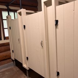
    Copper Falls State Park - Rustic (but clean) restrooms

    Rustic (but clean) restrooms

    Copper Falls State Park

    See all

    Interstate Falls

    Interstate Falls

    4.0(1 review)
    35.2 mi

    Called Interstate Falls because it's directly on the MI/WI border, this spot is only about a 10…read moreminute drive from Ironwood, MI, and only about a 10 minute hike from the parking lot. We saw lot of fun fungi on our hike in and spotted some folks foraging some of the mushrooms and even overheard them saying that they had found some chanterelles. It was an easy hike in on the main path, or you can switch it up to some more tretcherous terrain slightly closer to the falls along the stream (hiking poles recommended if you do so, especiallyif it's been raining recently). It appears that they recently redid all of the steps down to the main waterfall, but there are probably the equivalent of a 3 or 4 story building worth of stairs, which definitely winded a member of our party experiencing some health issues. The falls themselves are about about 15 feet high and there are some miini waterfalls along the a lot of the path on your way in as well. Beware: Google Maps may send you the wrong way. Based on a sign on someone's driveway on the route that Google told us to take that says it's private property, I gather that Google regularly tries to route folks through what it thinks is a public road but is clearly private property. I feel like this happens pretty regularly and that's that Google maps also seems to be unaware of unaware of incredibly major road construction projects. Its vexing to say the least. These lousy directions cost us about 15 minutes, so be sure to double check your route and enter from the MI side, not the WI one.

    Photos
    Interstate Falls
    Interstate Falls
    Interstate Falls

    See all

    Meyers Beach- Bayfield Sea Caves

    Meyers Beach- Bayfield Sea Caves

    4.8(4 reviews)
    36.1 mi

    We hiked the Lakeshore Trail from the Meyers Beach parking lot. (National Park Service. $5 parking…read morefee; $2.50 if you have a Senior Pass or Access Pass. May, 2023). As noted by others, this is a launch point for kayaks to launch for views of the sea caves and cliffs. We were at this location twice in late May, 2023, and national park Rangers were there on both days (Wednesday, Friday) ensuring that kayakers were prepared for the rough and cold waters, and to provide guidance to hikers. There are clean vault toilets at the location. Regarding the Lakeshore Hike, we did about 2.2 miles of the hike, returning on the same trail to make it about 4.4 miles roundtrip. The trail continues to a campground site (I believe NPS reservations are required) but we didn't go that far. The first 1.8 miles are largely inland, without views of Lake Superior. Of this segment, the first 0.7 miles are almost completely on a double plank boardwalk that goes over swampy land in parts. It requires some stepping up and down on planks, following terrain changes. After you cross a service road at 0.7 miles, the trail alternates between plank boards and regular trails. As you approach the crevasse at 1.8 miles, there are quite a few ascents and descents wherein you go down to a stream-bed and then back up. Some of these are steep but have logs to help with footing. The stream crossings all had sturdy boards or bridges to cross. At 1.8 miles, you reach the crevasse area with views of Lake Superior. Take a look on both sides to see sea caves and the deep crevasse. There are benches here too so it made a great lunch spot. Be careful not to get too close to the edges. It's a long way down! Beyond the crevasse, walk another 0.4 miles to the "basin". This stretch is relatively easy (flat) walking with spectacular views. My husband, who has been hiking in the Himalayas recently, found the entire trail to be easy. For me, I'd characterize it as moderately challenging. On the positive side, there is very little elevation change, so I wasn't huffing and puffing. However, I have balance issues, so I didn't particularly like the footing for the ascents/descents to the stream beds nor all of the roots on the trail. Some of the steps up and down, even on the boardwalk, were also a bit too high for my short legs! Having walked with hiking poles and an occasional hand from my husband helped. Finally, remember bug spray. The mosquitoes are active. 4-star rating overall instead of 5 due to distance required to walk to get views of the sea caves and mosquitoes. 5 stars for the Park Service.

    You have to come check out the sea caves on the shoreline of Lake Superior. Meyers beach is the…read morelaunching point for kayaks. It's also the location for the hiking trail. The views from the water are beautiful! I highly recommend the water instead of the walking trail. There are multiple vendors you can rent kayaks and wet suits from. You can even take a guided tour. We personally, have our own kayaks and decided to do our own trip. The DNR do sit at the beach and give you the whole spiel on safety and risks. It is recommended to use sea kayaks due to the rough waters of Lake Superior. We have used normal lake kayaks and used good judgement on the water/ weather conditions. Both times were just fine on the normal kayaks. Just be careful. The waters are freezing all year-round and if you do go overboard near the caves there's no good spot to pull off. Check out my pics of the stunning caves!

    Photos
    Meyers Beach- Bayfield Sea Caves
    Meyers Beach- Bayfield Sea Caves
    Meyers Beach- Bayfield Sea Caves

    See all

    Hunt Hill Nature Center - Nature

    Hunt Hill Nature Center

    5.0(2 reviews)
    58.5 mi

    A great place to take the family for summer camps, beautiful hiking, nature education and tons of…read moreprograma

    This is going to be one of those reviews where I open with a quote/poem. Today's selection will be…read moreone of my favorites from Wendell Berry: When despair for the world grows in me and I wake in the night at the least sound in fear of what my life and my children's lives may be, I go and lie down where the wood drake rests in his beauty on the water, and the great heron feeds. I come into the peace of wild things who do not tax their lives with forethought of grief. I come into the presence of still water. And I feel above me the day-blind stars waiting with their light. For a time I rest in the grace of the world, and am free. Now that I got that out of my system, I love this place. They offer a ton of camps and classes for children and adults all centered around nature and conservation. I rememember coming to the day camps here and having a blast. I did the Spanish Lanuage immersion camp, general day camp, but never the week long over night. They offer cabins for rental as well. There was this one we went to that was like way out there on this trail and built from super old wood in a lincoln log kind of way. And now just looking at their website, they apparently rent that out too on a nightly basis. Ooh and the bogs. They have this massive bog on the property that you can walk through and it has all these crazy species of plants. There's even one of those insect eating plants and orchids and stuff. Now that I'm thinking about it, this place would make for a great Yoga retreat. If you're reading this Ms. Hunt or whoever owns this place, you should explore the idea of a partnership with a Yoga studio. You could be like the Kripalu of the midwest.

    Photos
    Hunt Hill Nature Center - Nature

    Nature

    Hunt Hill Nature Center - Nature

    Nature

    Hunt Hill Nature Center - An autumn day at the Bog boardwalk. Photo taken by L. Ward.

    See all

    An autumn day at the Bog boardwalk. Photo taken by L. Ward.

    Morgan Falls St. Peter's Dome Trail - hiking - Updated July 2026
    Loading...
    Loading...
    Loading...