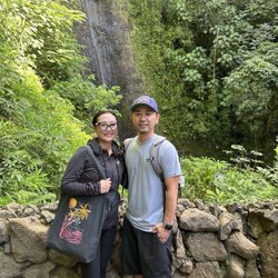
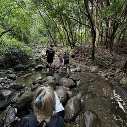
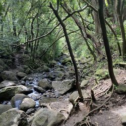
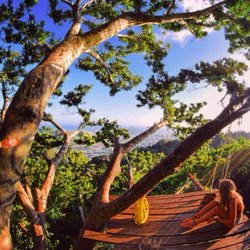
Mount Olympus via Kolowalu Photos


You might also consider
More like Mount Olympus via Kolowalu
Recommended Reviews - Mount Olympus via Kolowalu
Start your review...

Reviews With Photos

My favorite hike of all time. Sea, mountains, partial shade, trade winds, at the top of mount Olympus, you get a 360 view including the Lanikai pillboxes and the city skyline. It was so surreal. The hike is intermediate since it goes up and down for the most part at the beginning, letting you rest between those switches. Gets harder once you get pass the two signs and have to start using the ropes to climb up, but still very manageable! So worth the work. Must do!

This is a GREAT hike!!! Definitely an adventure if you're looking for one. Unfortunately, I'm out of shape so I struggled haha but it's totally worth it. I would say if you're an inexperienced hiker, be prepared for more than 2-3 hours of hiking. Also, if you don't want to get down and dirty, make sure to go on a nice and sunny day that wasn't rainy the day before or day of, because this genius over here fell and got caked in mud :-)

ALERT Dog friendly hike this is one of the best hikes that I know that are extremely dog friendly and an easy hike for beginners trying to take a little bit more risk other than a regular trail. This hike is located on the top of saint louis heights, this isn't a sunny hike but instead almost a narnia oasis. Filled with fun trees and covered areas also with some beautiful look out spots. If you are ever feel extremely adventurous this hike wraps around into tantalus so you could do the whole ridge. I highly recommend this hike to everybody! Family friendly and a great date spot! There are barbecue areas in the begging of the hike so you can also go there. Bathrooms and water fountains are available as well. Parking can be hard on a weekend but during the week days you should have no problem, there is around 15 stalls or so there. Enjoy a little Mother Nature and try and new hidden gem hike.


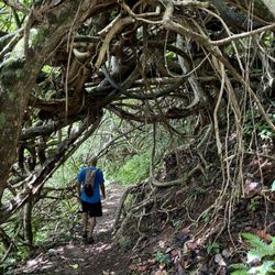
I somehow ended up on this trail, after I initially wanted to do the Pu'u' pia which starts in the same area. Talks to a guy walking his dog about street parking and where the trailhead was, he said something like: you want to take the right one (trail). Later on I figured that he must have said: you do NOT want to take the right one *lol* It's been raining when I got there, everything was very slippery, roots and leaves everywhere. The incline kicked my ass!!!! I did not know what I was in for! I think I made it almost to the top (from there on you'd have to go long the ridge), but decided to turn around at some point. I was by myself and had no hiking stick (man, I would have paid money for a hiking stick up there!!) plus I didn't really know where I was going, and how long his would take me. AND: I'd have to go all the way back down!! I ended up doing so partly sliding down on my butt and hands. Too bad I never made it to the "end" :( the views were already pretty sweet anyways, and I've been to Wa'ahila before, so I kinda did the whole thing. Sometimes you have to decide between being smart and being adventurous, and I -for once - chose being smart. So if you go I recommend a hiking stick if it's been raining, water ( I brought 24 oz) and repellant.


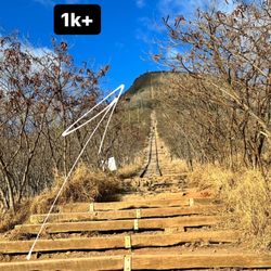
One line summary: 6.6 miles, 4 hour hike roundtrip (not including rest at the peak). We actually went up to Mt. Olympus from the Wa'ahila Ridge Trail, but whichever way you get here BE PREPARED. This hike will kick your butt, at least it did for us. We were not prepared for this one. Countless times we were going to throw in the towel but pushed to the end. Unlike most of the major ridge peak hikes (Kuliouou, Mariner's Ridge and Hawaii Loa Ridge) the finish point at Mt. Olympus doesn't have a large area to relax and take in the view. Still, you won't find many people up here because this hike is pretty tough. At least for us. The total hike was 6.6 miles (according to Mapmyhike app). It took us about 2 hours and 15 mins to get from the Wa'ahila Ridge Trail head to the top of Mt. Olympus. It took us about 1 hour and 45 mins to get back down. Part of the problem was that we were just so exhausted that climbing out of Wa'ahila Ridge Trail took us much longer than it should have. There are A LOT of ropes on this trail, A LOT of going up/down, up/down, up/down... so that when you're going back down (finished) the trail you still are working out after being exhausted. There is a section of ropes that I would say is about 50 feet up a pretty steep incline, a part of this has small footholds and another part is just hillside you can scale (with ropes). Either way, pretty wicked for someone that isn't prepared. Once you hit that section of ropes you're close to the end but still not quite there, you'll want to give up but push a little more. The views are pretty amazing at the top and you'll have some great panoramic shots from Hawaii Kai to Diamond Head all the way to Ewa Beach from the last 1/2 mile as you're ascending. The views of Manoa get even more dramatic but the views of Waikiki and Kakaako are pretty fantastic too. I know we'll be back to do this one again but it will definitely be awhile, this was truly one of the harder hikes we've been on. read more
 but absolutely an amazing view of Honolulu. From Hawaii Kai to Ewa Beach, the panoramic views are WOW! - Hiking Near Me - Honolulu, Hawaii")


After my first failed attempt at a hike last week I was all about "maintained" hikes this week. Mount Olympus had been on my list for some time but I had been avoiding it because its known for being a cloud magnet and it had been cloudy all week. I woke up to cloudy skies but I was in need of a hike so we decided to attempt hiking up to the top of Mount Olympus via the Kolowalu Trail. The Kolowalu trail shares a trailhead with Pu'u pia but is a steeper and shorter alternative route to get up to Wa'ahila Ridge. Most of Kolowalu was covered and cool which was a nice change from most of the hot exposed ridge hikes I had been doing but it was definitely no easy walk in the park. The trail is steep and never really plateaus out, so don't plan on having a picnic or anything. I think it took us about an hour till we got to the junction of Kolowalu and Wa'ahila Ridge. At the junction you will see a sign warning you that upper Wa'ahila Ridge is unmaintained, don't let that scare you away. There a couple narrow, sketchy spots at the end but nothing that can't be done if you stay on the trail and don't try anything stupid. :-) From the beginning of the junction, to the top expect to go over at least 4 or 5 hills. Make sure you have shoes with good traction because you'll be doing a lot of climbing up red dirt stairs that you see on most of the other Ko'olau trails.You'll think you're close, but your not. I think we came across a couple of open grassy areas to take a break, but unfortunately those are not the summit. Once we actually got to the top, we walked along the ridge with Olomana, Kaneohe on our left and Ka'au crater on the right. It was my first time seeing Ka'au crater from the left side, since Lanipo gives you a good view from the right. We finally made it and were all smiles when we saw the stake with a few pink ribbons tied on it. It was pretty windy so we didn't hang out for too long. It rained on our way down so I cannot emphasize the importance of good shoes. Thank god for my vibrams because I think I could have gotten seriously hurt if I had been in old sneakers. Make sure to bring water, snacks, and a extra t-shirt for after. Both of my friends were shivering at dinner after because they were still in their sweat and rain soaked shirts. *Going up to Mt. Olympus from the beginning of the Wa'ahila Ridge is an easier route that starts from the top of St. Louis Heights. YELP 365: 125/365 read more


11 years ago
My favorite hike of all time. Sea, mountains, partial shade, trade winds, at the top of mount Olympus, you get a 360 view including the Lanikai pillboxes and the city skyline. It was so surreal. The hike is intermediate since it goes up and down for the most part at the beginning, letting you rest between those switches. Gets harder once you get pass the two signs and have to start using the ropes to climb up, but still very manageable! So worth the work. Must do! read more


8 years ago
This is a GREAT hike!!! Definitely an adventure if you're looking for one. Unfortunately, I'm out of shape so I struggled haha but it's totally worth it. I would say if you're an inexperienced hiker, be prepared for more than 2-3 hours of hiking. Also, if you don't want to get down and dirty, make sure to go on a nice and sunny day that wasn't rainy the day before or day of, because this genius over here fell and got caked in mud :-) read more

ALERT Dog friendly hike this is one of the best hikes that I know that are extremely dog friendly and an easy hike for beginners trying to take a little bit more risk other than a regular trail. This hike is located on the top of saint louis heights, this isn't a sunny hike but instead almost a narnia oasis. Filled with fun trees and covered areas also with some beautiful look out spots. If you are ever feel extremely adventurous this hike wraps around into tantalus so you could do the whole ridge. I highly recommend this hike to everybody! Family friendly and a great date spot! There are barbecue areas in the begging of the hike so you can also go there. Bathrooms and water fountains are available as well. Parking can be hard on a weekend but during the week days you should have no problem, there is around 15 stalls or so there. Enjoy a little Mother Nature and try and new hidden gem hike. read more
11 years ago
14 years ago
14 years ago
12 years ago
Challenging hike w/ beautiful views. Also the sign "more trees less asshole" is not all true...a dude tried to push his gf/wife off the side of the cliff so she said. Not cool dude. read more

7 years ago

10 years ago
I somehow ended up on this trail, after I initially wanted to do the Pu'u' pia which starts in the same area. Talks to a guy walking his dog about street parking and where the trailhead was, he said something like: you want to take the right one (trail). Later on I figured that he must have said: you do NOT want to take the right one *lol* It's been raining when I got there, everything was very slippery, roots and leaves everywhere. The incline kicked my ass!!!! I did not know what I was in for! I think I made it almost to the top (from there on you'd have to go long the ridge), but decided to turn around at some point. I was by myself and had no hiking stick (man, I would have paid money for a hiking stick up there!!) plus I didn't really know where I was going, and how long his would take me. AND: I'd have to go all the way back down!! I ended up doing so partly sliding down on my butt and hands. Too bad I never made it to the "end" :( the views were already pretty sweet anyways, and I've been to Wa'ahila before, so I kinda did the whole thing. Sometimes you have to decide between being smart and being adventurous, and I -for once - chose being smart. So if you go I recommend a hiking stick if it's been raining, water ( I brought 24 oz) and repellant. read more


10 years ago
Great hike, bring hiking cleats. its around 5 miles. not for the faint of heart and dogs might have a hard time on this. read more


9 years ago
9 years ago
14 years ago
14 years ago
12 years ago
I have done this hike twice, once it was clear skies and hot with that came incredible views, the second time it was cold and misty, with that came, no views muddy trails, dirty shoes, lots of challenge and fun! Either way bring lots of water, no food is necessary it's only a 4 hour hike, we tracked it with map my run and got 8 miles in and turned around. Coming back was tough on my knees, it's mostly downhill for the entire way back, hehe you know what that means on the way there :) it's 8 miles from the parking lot, so that includes Waahila Trail. This is either not very popular or too hard for people, but it's so beautiful up there if you push yourself, peaceful and quiet. The parking lot is usually full of people doing recreational activities which I love, because as you ascend the first part it winds and slowly cuts of the noise, and you begin to realize that your 10 mins out of Waikiki and your in the forest and away from all the chaos. The top point has no flat obvious ending point, other than the view of both sides of the island :) which is incredible. There are some great resting points on the way that would work well for picnics. read more

10 years ago
14 years ago
9 years ago
More info about Mount Olympus via Kolowalu
3640 Alani Dr
Honolulu, HI 96822
Manoa
Directions
Hours
Outdoor Amenities
Ask the Community - Mount Olympus via Kolowalu
Review Highlights - Mount Olympus via Kolowalu
You might also consider


Mount Olympus via Kolowalu - hiking - Updated June 2026
Best of Honolulu
People found Mount Olympus via Kolowalu by searching for…
Hiking Trails in Honolulu, Hawaii
Rope Swing in Honolulu, Hawaii
View Points in Honolulu, Hawaii
Make Out Spot in Honolulu, Hawaii
Waterfall Hike in Honolulu, Hawaii
Dog Friendly Hiking Trails in Honolulu, Hawaii
Scenic Overlook in Honolulu, Hawaii
Easy Hikes in Honolulu, Hawaii
Skyline View in Honolulu, Hawaii
Beach BBQ Pits in Honolulu, Hawaii
Running Trails in Honolulu, Hawaii
Bamboo Forest in Honolulu, Hawaii
Hiking Club in Honolulu, Hawaii
Walking Trails in Honolulu, Hawaii
Photo Spots in Honolulu, Hawaii
Night Hike in Honolulu, Hawaii
Secluded Spots in Honolulu, Hawaii
Stairs Workout in Honolulu, Hawaii
Playgrounds in Honolulu, Hawaii
Trending Searches in Honolulu, HI
Beaches near Mount Olympus via Kolowalu
Boat Rental near Mount Olympus via Kolowalu
Cliff Jumping near Mount Olympus via Kolowalu
Day Trips near Mount Olympus via Kolowalu
Dog Friendly Trails near Mount Olympus via Kolowalu
Fishing Spots near Mount Olympus via Kolowalu
Free Kids Activities near Mount Olympus via Kolowalu
Jet Ski Rental near Mount Olympus via Kolowalu
Kayak Rental near Mount Olympus via Kolowalu
Lakes & Ponds near Mount Olympus via Kolowalu
Off Road Trails near Mount Olympus via Kolowalu
Outdoor Activities near Mount Olympus via Kolowalu
Pick Your Own Farms near Mount Olympus via Kolowalu
Places To Walk Around near Mount Olympus via Kolowalu
Public Shower near Mount Olympus via Kolowalu
Rock Quarry near Mount Olympus via Kolowalu
Scenic Drive near Mount Olympus via Kolowalu
Scenic Night View near Mount Olympus via Kolowalu
Secluded Spots near Mount Olympus via Kolowalu
Soccer Store near Mount Olympus via Kolowalu
Splash Pad near Mount Olympus via Kolowalu
Strawberry Picking near Mount Olympus via Kolowalu
Sunrise View near Mount Olympus via Kolowalu
Swimming Holes near Mount Olympus via Kolowalu
Swimming Lakes near Mount Olympus via Kolowalu
Swimming Pools near Mount Olympus via Kolowalu
Watch Sunset near Mount Olympus via Kolowalu
Browse Articles
Browse Nearby
BEST of Honolulu, Hawaii Coffee near Mount Olympus via Kolowalu
BEST of Honolulu, Hawaii Things to Do near Mount Olympus via Kolowalu
BEST of Honolulu, Hawaii Restaurants near Mount Olympus via Kolowalu
BEST of Honolulu, Hawaii Parks near Mount Olympus via Kolowalu
BEST of Honolulu, Hawaii Breakfast near Mount Olympus via Kolowalu
BEST of Honolulu, Hawaii Waterfalls near Mount Olympus via Kolowalu
BEST of Honolulu, Hawaii Taxis near Mount Olympus via Kolowalu
Browse Brands
Related Searches in Honolulu, HI
Affordable Kayak Rental Services in Honolulu, Hawaii
Best Fishing Locations and Guides in Honolulu, Hawaii
Best Nature Trails for Hiking in Honolulu, Hawaii
Best Places for Horseback Riding in Honolulu, Hawaii
Best Waterfalls and Swimming Holes in Honolulu, Hawaii
Check Out Off Road Trails in Honolulu, Hawaii
Discover Dog Friendly Trails to Explore in Honolulu, Hawaii
Discover Kid Friendly Hiking Trails in Honolulu, Hawaii
Discover Scenic Hiking Trails in Honolulu, Hawaii
Discover Scenic Waterfall Spots in Honolulu, Hawaii
Discover Walking Parks in Honolulu, Hawaii Near You
Discover a Hiking Trail in Honolulu, Hawaii
Discover the Best Night Hike Trails in Honolulu, Hawaii
Dog-Friendly Hikes With Dogs in Honolulu, Hawaii
Enjoy Camping Adventures Around Honolulu, Hawaii
Enjoy Kayaking Adventures in Honolulu, Hawaii
Enjoy Tent Camping Spots Around Honolulu, Hawaii
Enjoy a Beautiful Waterfall Hike in Honolulu, Hawaii
Enjoy a Peaceful Nature Walk in Honolulu, Hawaii
Enjoy the Best Picnic Spots and Ideas in Honolulu, Hawaii
Enjoy the Best Walking Path in Honolulu, Hawaii
Enjoy the Best Walking Trails in Honolulu, Hawaii
Exciting Cliff Jumping Spots in Honolulu, Hawaii
Explore Beautiful Parks and Green Spaces in Honolulu, Hawaii
Explore Easy Hikes Perfect for All in Honolulu, Hawaii
Explore Fun Activities to Do in Honolulu, Hawaii
Explore Popular Campgrounds Near Honolulu, Hawaii
Explore the Best Beach Spots in Honolulu, Hawaii
Explore the Best Swimming Holes Around Honolulu, Hawaii
Explore the Best Trail Options in Honolulu, Hawaii
Family Friendly Hiking With Kids in Honolulu, Hawaii
Find Popular Ziplining Spots Around Honolulu, Hawaii
Find the Best Parks for Picnics in Honolulu, Hawaii
Find the Best Scenic View Locations in Honolulu, Hawaii
Great Places to Walk in Honolulu, Hawaii
Hike the Popular Waterfall Trail in Honolulu, Hawaii
Hiking Trails With Waterfalls in Honolulu, Hawaii
Off Leash Dog Hiking Trails in Honolulu, Hawaii
Plan a Scenic Drive Route Near Honolulu, Hawaii
Popular Outdoor Activities to Try in Honolulu, Hawaii
Popular Picnic Spots to Visit in Honolulu, Hawaii
Safe River Swimming Areas in Honolulu, Hawaii
Safe and Fun Parks for Kids in Honolulu, Hawaii
Top Climbing Spots and Gyms in Honolulu, Hawaii
Top Paddleboarding Activities in Honolulu, Hawaii
Top Places for Snorkeling in Honolulu, Hawaii
Top Running Trails to Explore in Honolulu, Hawaii
Top Swimming Spots and Pools in Honolulu, Hawaii