Mt. Burdell Open Space Preserve Photos


You might also consider
More like Mt. Burdell Open Space Preserve
Recommended Reviews - Mt. Burdell Open Space Preserve
Start your review...

Reviews With Photos

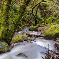
I always drove past Mount Burdell on the way to Petaluma and never went. Now I wonder why I didn't go sooner as it's so vast with amazing views. 1,500 feet at the top, you can see quite far away. There are many different trails to roam, I still haven't explored them all, but the main one is the Michako/ Middle Burdell Trail loop which is about 3.4 miles. There are also various entry points, the most popular is on San Andreas Dr. There is even an access trail through Ollompi Park but that would add another mile or so. I think it's best to go in winter and spring. In the winter there are a couple streams running and it's very green. In the spring WOW, it pops with color. It's still very green, there are tons of pretty wildflowers, some cows around; it's simply breathtaking. With the depth of field looking out from the mountain at everything it feels like you are in the book Heidi. I'd avoid this place in the summer. San Marin can get quite hot and while there is some shade I definitely wouldn't come here in the middle of the day. The green grass has turned yellow and straw-like. All the bush is really dry and feels very fire hazzardy which is quite the opposite experience as the spring.

Beautiful open space preserve with tons of pretty rolling hills and great city views. I hiked here with a friend last year and it was a great little workout for the both of us. The actual preserve is quite expansive but you wouldn't know it by simply looking at the entrance from San Andreas Dr. We embarked on a 5.5 mile loop trail which covers the Deer Camp Fire Road, Old Quarry and Michako trails. We began the hike going clockwise to get steeper hills out of the way. This trail loop is almost completely exposed with very little shade. However, depending on the time of year and day that you come, there may be a cool breeze. The wild life is rampant here. We passed by baby cows, squirrels, and birds on our way through the trails. The initial ascent going clockwise on Deer Camp Fire Road is probably the toughest part of this hike. It isn't super steep, but it does reach a relatively high elevation in a short distance. What's nice is that you'll have 360 degree views of the beautiful rolling hills all round you. So when you need to take those breaks, they'll be met with some killer views. You should definitely watch out for cow pooh and stretches of mud on the trails. This place doesn't seem to get too crowded which is nice. At some of the highest points, you'll have some excellent views of the city down below. Going back down on the Old Quarry trail gets a bit steep and rocky. Definitely bring your hiking poles if you knees bother you on the way down steepish hillsides. This is actually on the backside of Olompali State Park, so you can extend your hike and connect there as well. There's actually lots of different hiking trails tucked within this preserve which isn't noticeable from the start. This was a really enjoyable little discovery. If you're looking for a secluded hike with beautiful rolling hills, city views, and some heart pumping inclines, Mount Burdell has a lot to offer.

Fun fact: Almost 85% of Marin County is permanently protected, dedicated open space. Additional Fun Fact: Novato's Mt. Burdell Open Space Preserve is the largest of Marin's open space preserves. Who knew? I made my way to Mt. Burdell Open Space Preserve today to experience what's on offer and though those living in Central, South, and West Marin rarely head north for a visit to Novato, it didn't take long for me to decide they ought to. Quite a nice, vast preserve is here for hikers to enjoy. There's many entrances to the preserve and I was pleased that I'd printed out a single page map of the trails before heading here. Entering via a fire road off San Andreas Court, it wasn't long before I was experiencing the expansive views encountered on the way to Mt. Burdell's 1550 foot peak. The whole way up I was on a wide trail (San Andreas Fire Road, then Cobblestone Fire Road). Other hikers were present but the it's easy to maintain distance on the fire roads and the higher you get, the fewer people you encounter. Still, without exception, everyone respectfully maintained distance and covered their face on the fire roads. The view from the peak is somehow less stunning or impressive than views you'll notice as you hike up the fire roads. As such, I'd encourage taking your photos when the mood strikes, before you reach the top (which is oddly flat and wide, not what one traditionally thinks of as a peak). From the peak there are several options to get back down but I generally opt for the choice that doesn't have me retracing my steps. I went down the very steep Old Quarry Trail, marveling at those who chose to ascend it instead. I'm not sure which was harder. A hiking pole is definitely recommended on this path, for use as a third leg. Other miscellany: * 5.4 total miles via the route I hiked. * Basically no shade in this preserve; best to visit on a cool day. * Trails are well-marked and easy to follow but having a trail map with you will definitely help guide you. * Dogs permitted, even off-leash (under voice control) on fire roads. * Clean, immaculate in fact. I spotted no trash during my entire 2.5 hour hike. * Free and easy street parking. * Probably not good for small children; the climb might be too much.
")
In the past I've hiked Mt. Burdell from Olompali State Park and this time started from off of San Marin Drive. Free parking at this trailhead in a residential neighborhood which is appreciated. It is not as woodsy as the other side, but the trail up is more direct and you are able to see bay views earlier. There was quite a lot of wind today, which kept us cool, but without the wind it could get very warm due to the amount of open space. Not very crowded here which was another plus. Did not encounter any benches on our route so not ideal for a picnic.

Not sure what this spot is like when it's not quarantine, but I loved how quiet it was on a weekday. We maybe crossed paths with 2 other people during our 1.5hr hike here. The hike is really nice and moderate with mostly unshaded paths. You'll get a view of Novato from the top and probably see quite a few lizards scurry by. In times like this where we're not trying to touch surfaces, I really appreciate that they have fencing that allows you to pass through without opening or touching a gate (hard to explain, but you'll see when you get there).


This hiking trail was beautiful! All of the trails are really well marked, and you really get a chance you get out in the wilderness. The animals aren't afraid of you and we had cows walking across the path right in front of us. The views once you get higher up are quite wonderful. It was a gorgeous and hot Saturday, and I was shocked that we only came across a few other people. Everyone we saw were with their dogs, so I'm guessing it's a very dog-friendly place. It's easy to park right along the side of the road at the entranceway. If you're looking to Google Map directions, this is the address that my GPS came up with: 483 San Andreas Dr. Novato, CA 94945 We were looking for a moderate hike, and easily found a loop of San Andreas Fire Road - Middle Burdell Fire Road - some smaller marked trails - San Marin Fire Road, which ended up being about 4 miles total. The other trails looked interesting too. The only downfall to hiking this trail is you have to watch your step on the trail to avoid the cow steamers, and possibly related, you should really wear bug spray since bugs are all over the place. My goal for next time is to find Hidden Lake, we were looking for it but it must be really well hidden!


Park on the street at the entrance on San Andreas Drive. Walk up the San Andreas Fire Road to begin your hike. Keep to the right as you hike. Check out the map that I posted. Bring your whole family - this hike is considered easy/moderate. Some hills at the beginning, but nothing too challenging. Furry friends (dogs) are welcome! They can be off-leash as long as you're able to control your dog with voice commands. Enjoy the rolling hills... and bring your camera!!

For a few years, my family lived on San Marin Drive, so we considered ourselves lucky to have this open space preserve so close to home. We treated it like the best backyard we never owned! Every season of the year has its own special touches upon this place- but late summer/ early fall is a personal favorite of mine. The dry golden fields are picturesque, the temperature is warm enough to hike around without a jacket (but there are tick warnings, so protect your legs), and the clear skies allow you to see all of northern/ central Novato, with the rare glimpse of Mount Diablo far into the distance. I've only encountered friendly folks on the numerous trails here. Those trails can take you up the mount to the hidden lake at the top, which I am told is worth it. For those who don't live within walking distance to the numerous entrances to the preserve, there is street parking on the quiet residential roads along San Marin Drive.

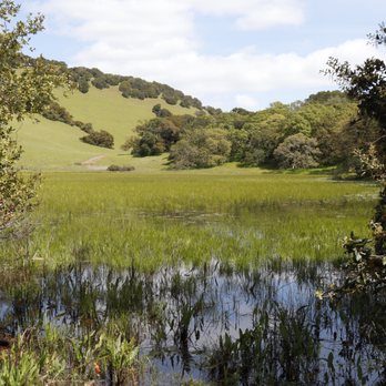
Mt. Burdell is a huge open space tucked away in Novato. It has multiple entrances along San Marin Drive. The reason I love this space is how is changes through out the year. In the summer, it's a great place to work up a sweat and get some exercise in. When the rainy season hits, creeks kick up and a lake is formed. The views are amazing from the top and it leads right into Olompali park as well, which also has a really easy and beautiful hike. One thing to look out for: Fast bikers, horse riders and of course, the cow herd that grazes during moo moo season. It's the place to go in the area to get away from the noise if you need to talk to the trees. Sometimes there are interesting people out there like this couple sitting in a tree singing to each other in the middle of nowhere. Looking back it was pretty pimp actually.

I visited this Open Space Preserve by accessing the area near the Bay Club Rolling Hills in Novato. On this day, I was on my mountain bike and had only hiked here one time prior as I'm new to the area. I would say this park is better for hiking than mountain biking unless you live nearby. But there are better destination mountain biking choices in the area. For that reason I only give it 4 stars. That said, its a lovely regional park for wildlife viewing, stunning vistas of the bay and just being in a well preserved swath of oak lined rolling hills of Northern California. I really had a nice time exploring the paths on my bike and may have missed one of the better single track sections to the southeast side of the park. Next time! read more


I always drove past Mount Burdell on the way to Petaluma and never went. Now I wonder why I didn't go sooner as it's so vast with amazing views. 1,500 feet at the top, you can see quite far away. There are many different trails to roam, I still haven't explored them all, but the main one is the Michako/ Middle Burdell Trail loop which is about 3.4 miles. There are also various entry points, the most popular is on San Andreas Dr. There is even an access trail through Ollompi Park but that would add another mile or so. I think it's best to go in winter and spring. In the winter there are a couple streams running and it's very green. In the spring WOW, it pops with color. It's still very green, there are tons of pretty wildflowers, some cows around; it's simply breathtaking. With the depth of field looking out from the mountain at everything it feels like you are in the book Heidi. I'd avoid this place in the summer. San Marin can get quite hot and while there is some shade I definitely wouldn't come here in the middle of the day. The green grass has turned yellow and straw-like. All the bush is really dry and feels very fire hazzardy which is quite the opposite experience as the spring. read more


Beautiful open space preserve with tons of pretty rolling hills and great city views. I hiked here with a friend last year and it was a great little workout for the both of us. The actual preserve is quite expansive but you wouldn't know it by simply looking at the entrance from San Andreas Dr. We embarked on a 5.5 mile loop trail which covers the Deer Camp Fire Road, Old Quarry and Michako trails. We began the hike going clockwise to get steeper hills out of the way. This trail loop is almost completely exposed with very little shade. However, depending on the time of year and day that you come, there may be a cool breeze. The wild life is rampant here. We passed by baby cows, squirrels, and birds on our way through the trails. The initial ascent going clockwise on Deer Camp Fire Road is probably the toughest part of this hike. It isn't super steep, but it does reach a relatively high elevation in a short distance. What's nice is that you'll have 360 degree views of the beautiful rolling hills all round you. So when you need to take those breaks, they'll be met with some killer views. You should definitely watch out for cow pooh and stretches of mud on the trails. This place doesn't seem to get too crowded which is nice. At some of the highest points, you'll have some excellent views of the city down below. Going back down on the Old Quarry trail gets a bit steep and rocky. Definitely bring your hiking poles if you knees bother you on the way down steepish hillsides. This is actually on the backside of Olompali State Park, so you can extend your hike and connect there as well. There's actually lots of different hiking trails tucked within this preserve which isn't noticeable from the start. This was a really enjoyable little discovery. If you're looking for a secluded hike with beautiful rolling hills, city views, and some heart pumping inclines, Mount Burdell has a lot to offer. read more


Fun fact: Almost 85% of Marin County is permanently protected, dedicated open space. Additional Fun Fact: Novato's Mt. Burdell Open Space Preserve is the largest of Marin's open space preserves. Who knew? I made my way to Mt. Burdell Open Space Preserve today to experience what's on offer and though those living in Central, South, and West Marin rarely head north for a visit to Novato, it didn't take long for me to decide they ought to. Quite a nice, vast preserve is here for hikers to enjoy. There's many entrances to the preserve and I was pleased that I'd printed out a single page map of the trails before heading here. Entering via a fire road off San Andreas Court, it wasn't long before I was experiencing the expansive views encountered on the way to Mt. Burdell's 1550 foot peak. The whole way up I was on a wide trail (San Andreas Fire Road, then Cobblestone Fire Road). Other hikers were present but the it's easy to maintain distance on the fire roads and the higher you get, the fewer people you encounter. Still, without exception, everyone respectfully maintained distance and covered their face on the fire roads. The view from the peak is somehow less stunning or impressive than views you'll notice as you hike up the fire roads. As such, I'd encourage taking your photos when the mood strikes, before you reach the top (which is oddly flat and wide, not what one traditionally thinks of as a peak). From the peak there are several options to get back down but I generally opt for the choice that doesn't have me retracing my steps. I went down the very steep Old Quarry Trail, marveling at those who chose to ascend it instead. I'm not sure which was harder. A hiking pole is definitely recommended on this path, for use as a third leg. Other miscellany: * 5.4 total miles via the route I hiked. * Basically no shade in this preserve; best to visit on a cool day. * Trails are well-marked and easy to follow but having a trail map with you will definitely help guide you. * Dogs permitted, even off-leash (under voice control) on fire roads. * Clean, immaculate in fact. I spotted no trash during my entire 2.5 hour hike. * Free and easy street parking. * Probably not good for small children; the climb might be too much. read more


6 years ago
In the past I've hiked Mt. Burdell from Olompali State Park and this time started from off of San Marin Drive. Free parking at this trailhead in a residential neighborhood which is appreciated. It is not as woodsy as the other side, but the trail up is more direct and you are able to see bay views earlier. There was quite a lot of wind today, which kept us cool, but without the wind it could get very warm due to the amount of open space. Not very crowded here which was another plus. Did not encounter any benches on our route so not ideal for a picnic. read more
 - Hiking Near Me")


Not sure what this spot is like when it's not quarantine, but I loved how quiet it was on a weekday. We maybe crossed paths with 2 other people during our 1.5hr hike here. The hike is really nice and moderate with mostly unshaded paths. You'll get a view of Novato from the top and probably see quite a few lizards scurry by. In times like this where we're not trying to touch surfaces, I really appreciate that they have fencing that allows you to pass through without opening or touching a gate (hard to explain, but you'll see when you get there). read more


3 years ago
I've eaten here a few times and the menu is just awful, the food nonexistent. The service is worse, with no staff and lots of bugs. And whose idea was it to let COWS walk through the dining room? I've attached a pic of our server. 'Nuff said. read more

14 years ago
This hiking trail was beautiful! All of the trails are really well marked, and you really get a chance you get out in the wilderness. The animals aren't afraid of you and we had cows walking across the path right in front of us. The views once you get higher up are quite wonderful. It was a gorgeous and hot Saturday, and I was shocked that we only came across a few other people. Everyone we saw were with their dogs, so I'm guessing it's a very dog-friendly place. It's easy to park right along the side of the road at the entranceway. If you're looking to Google Map directions, this is the address that my GPS came up with: 483 San Andreas Dr. Novato, CA 94945 We were looking for a moderate hike, and easily found a loop of San Andreas Fire Road - Middle Burdell Fire Road - some smaller marked trails - San Marin Fire Road, which ended up being about 4 miles total. The other trails looked interesting too. The only downfall to hiking this trail is you have to watch your step on the trail to avoid the cow steamers, and possibly related, you should really wear bug spray since bugs are all over the place. My goal for next time is to find Hidden Lake, we were looking for it but it must be really well hidden! read more


5 years ago
Nice trails. Great view. Simply beautiful. A great place for couples to relax and enjoy nature. read more

Park on the street at the entrance on San Andreas Drive. Walk up the San Andreas Fire Road to begin your hike. Keep to the right as you hike. Check out the map that I posted. Bring your whole family - this hike is considered easy/moderate. Some hills at the beginning, but nothing too challenging. Furry friends (dogs) are welcome! They can be off-leash as long as you're able to control your dog with voice commands. Enjoy the rolling hills... and bring your camera!! read more

12 years ago
For a few years, my family lived on San Marin Drive, so we considered ourselves lucky to have this open space preserve so close to home. We treated it like the best backyard we never owned! Every season of the year has its own special touches upon this place- but late summer/ early fall is a personal favorite of mine. The dry golden fields are picturesque, the temperature is warm enough to hike around without a jacket (but there are tick warnings, so protect your legs), and the clear skies allow you to see all of northern/ central Novato, with the rare glimpse of Mount Diablo far into the distance. I've only encountered friendly folks on the numerous trails here. Those trails can take you up the mount to the hidden lake at the top, which I am told is worth it. For those who don't live within walking distance to the numerous entrances to the preserve, there is street parking on the quiet residential roads along San Marin Drive. read more

Mt. Burdell is a huge open space tucked away in Novato. It has multiple entrances along San Marin Drive. The reason I love this space is how is changes through out the year. In the summer, it's a great place to work up a sweat and get some exercise in. When the rainy season hits, creeks kick up and a lake is formed. The views are amazing from the top and it leads right into Olompali park as well, which also has a really easy and beautiful hike. One thing to look out for: Fast bikers, horse riders and of course, the cow herd that grazes during moo moo season. It's the place to go in the area to get away from the noise if you need to talk to the trees. Sometimes there are interesting people out there like this couple sitting in a tree singing to each other in the middle of nowhere. Looking back it was pretty pimp actually. read more

8 years ago
This is a great place to go hiking! It is fairly steep and the path has a lot of rocks. I do recommend having shoes with some traction that are more designed for trails as you run a risk of slipping going downhill if you walk too fast. It is a pretty hike and a good workout. I typically do between a 3-4 mile loop. People frequently bring their dogs, bike, and some even ride a horse. There are other options to extend the hike if you are wanting more. There is no parking lot here but you can park on the road with the line of cars. read more

9 years ago
12 years ago
7 years ago
17 years ago
16 years ago
There's so many trail heads to this Mountain. There is so many different levels of difficulty. You get great views when walking up of Marin, Mt diablo, S.F. ect.. Great place to see Marin rolling hill. read more


15 years ago
17 years ago
13 years ago
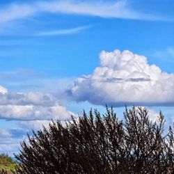
Gorgeous sweeping views of Novato and surrounding area from Mt. Burdell. You need not go all the way up, but the higher you go, the better the view. Path is not technical, so enjoyed by trail runners, dog walkers, and hikers. You can also see distant Diablo if you get high enough. Go in the mornings when it's cool, it heats up quick and very little shade to be found. read more


10 years ago
Mt Burdell is amazing! Has beautiful views, challenging hikes, solitude, awesome oak trees, lots of nooks to explore, and an incredible amount of history. The rock wall which extends the length of the crest, the quarry, and of course the spectacular rock carvings! The only reason this is not a five star location for me is the inaccessibility to Olympali, the legal accessibility. Plus the fact that someone thought it a good idea to build the modern border fence directly on top of the historical rockwall. read more


8 years ago
18 years ago
15 years ago
17 years ago
13 years ago
10 years ago
Page 1 of 2
More info about Mt. Burdell Open Space Preserve
Ask the Community - Mt. Burdell Open Space Preserve
Review Highlights - Mt. Burdell Open Space Preserve
You might also consider


Why does Yelp recommend reviews?
Mt. Burdell Open Space Preserve - hiking - Updated July 2026
Best of Novato
People found Mt. Burdell Open Space Preserve by searching for…
Trending Searches in Novato, CA
Blueberry Picking near Mt. Burdell Open Space Preserve
Boardwalk near Mt. Burdell Open Space Preserve
Boat Tours near Mt. Burdell Open Space Preserve
Cliff Jumping near Mt. Burdell Open Space Preserve
Cruising Spots near Mt. Burdell Open Space Preserve
Day Trips near Mt. Burdell Open Space Preserve
Dog Friendly Beaches near Mt. Burdell Open Space Preserve
Dog Friendly Things To Do near Mt. Burdell Open Space Preserve
Flower Fields near Mt. Burdell Open Space Preserve
Indoor Dog Park near Mt. Burdell Open Space Preserve
Jet Ski Rental near Mt. Burdell Open Space Preserve
Kayak Rental near Mt. Burdell Open Space Preserve
Kids Activities Indoor near Mt. Burdell Open Space Preserve
Lakes near Mt. Burdell Open Space Preserve
Off Road Trails near Mt. Burdell Open Space Preserve
Outdoor Activities near Mt. Burdell Open Space Preserve
Peach Picking near Mt. Burdell Open Space Preserve
Picnic Spots near Mt. Burdell Open Space Preserve
Places To Walk Around near Mt. Burdell Open Space Preserve
Playgrounds near Mt. Burdell Open Space Preserve
Public Beaches near Mt. Burdell Open Space Preserve
Public Shower near Mt. Burdell Open Space Preserve
River Swimming near Mt. Burdell Open Space Preserve
Rock Quarry near Mt. Burdell Open Space Preserve
Scenic Night View near Mt. Burdell Open Space Preserve
Scenic Overlook near Mt. Burdell Open Space Preserve
Splash Pad near Mt. Burdell Open Space Preserve
State Parks near Mt. Burdell Open Space Preserve
Surf Shop near Mt. Burdell Open Space Preserve
Swimming Holes near Mt. Burdell Open Space Preserve
Swimming Lakes near Mt. Burdell Open Space Preserve
Things To Do On A Rainy Day near Mt. Burdell Open Space Preserve
Things To Do With Kids near Mt. Burdell Open Space Preserve
Tubing near Mt. Burdell Open Space Preserve
Watch Sunset near Mt. Burdell Open Space Preserve
Water Parks near Mt. Burdell Open Space Preserve
Browse Nearby
BEST of Novato, California Coffee near Mt. Burdell Open Space Preserve
BEST of Novato, California Restaurants near Mt. Burdell Open Space Preserve
BEST of Novato, California Things to Do near Mt. Burdell Open Space Preserve
BEST of Novato, California Parks near Mt. Burdell Open Space Preserve
BEST of Novato, California Breakfast near Mt. Burdell Open Space Preserve
BEST of Novato, California Lakes near Mt. Burdell Open Space Preserve
BEST of Novato, California Campgrounds near Mt. Burdell Open Space Preserve
Browse Brands
Related Searches in Novato, CA
Affordable Kayak Rental Services in Novato, California
Best Dog Hiking Trails Around Novato, California
Best Fishing Locations and Guides in Novato, California
Best Nature Trails for Hiking in Novato, California
Best Off Leash Dog Parks in Novato, California
Best Parks for Parties and Events in Novato, California
Best Places for Horseback Riding in Novato, California
Best Sightseeing Experiences Available in Novato, California
Best Water Parks for Kids in Novato, California
Check Out Great Playgrounds in Novato, California
Check Out Off Road Trails in Novato, California
Discover Baseball Fields Around Novato, California
Discover Dog Friendly Trails to Explore in Novato, California
Discover Easy Hiking Trails Near Novato, California
Discover Fun Toddler Parks in Novato, California for Your Little One
Discover Kid Friendly Hiking Trails in Novato, California
Discover Lakes & Ponds to Explore in Novato, California
Discover Popular Bike Trails in Novato, California
Discover Soccer Fields in Novato, California Near You
Discover Top Nature Parks to Visit in Novato, California
Discover Top State Parks to Visit in Novato, California
Discover Walking Parks in Novato, California Near You
Discover a Hiking Trail in Novato, California
Discover the Best Beaches in Novato, California
Discover the Best Kids Park Spots in Novato, California
Discover the Best Night Hike Trails in Novato, California
Dog-Friendly Hikes With Dogs in Novato, California
Enjoy Camping Adventures Around Novato, California
Enjoy Kayaking Adventures in Novato, California
Enjoy Off Leash Dog Hikes in Novato, California
Enjoy Scenic Places to Walk in Novato, California
Enjoy a Beautiful Waterfall Hike in Novato, California
Enjoy the Best Picnic Spots and Ideas in Novato, California
Enjoy the Best Walking Path in Novato, California
Enjoy the Best Walking Trails in Novato, California
Explore Beautiful Parks and Green Spaces in Novato, California
Explore Easy Hikes Perfect for All in Novato, California
Explore Free Picnic Areas Around Novato, California
Explore Fun Activities to Do in Novato, California
Explore Parks With Pull Up Bars in Novato, California
Explore Picnic Parks Near Novato, California
Explore Popular Campgrounds Near Novato, California
Explore Popular Dog Walking Trails in Novato, California
Explore Popular Kids Parks Throughout Novato, California
Explore Popular Picnic Areas Around Novato, California
Explore Popular RV Parks Around Novato, California
Explore Scenic Lakes to Visit in Novato, California
Explore Top Dog Parks in Novato, California Near You
Browse Articles
People who viewed Mt. Burdell Open Space Preserve also viewed
Indian Valley Open Space Preserve
47 reviews
Dawn Falls
48 reviews
King Mountain
8 reviews
Robert Dollar Scenic Drive Hike
3 reviews
Phoenix Lake
75 reviews
Cascade Falls
40 reviews
Bon Tempe Lake
28 reviews
Lynwood Hill Park
2 reviews
Mt. Tamalpais Watershed/Phoenix Lake Trailhead
8 reviews
Camino Alto Open Space Preserve
2 reviews