Bon Tempe Lake Photos


 - Hiking Near Me - Fairfax, California")
You might also consider
More like Bon Tempe Lake
Recommended Reviews - Bon Tempe Lake
Start your review...

Reviews With Photos

Took an insane 12 mile hike loop past Bon Tempe Lake (actually a reservoir) to Alpine Lake and back. I love hiking here because the paths here can take you from a lake paths to wooded areas, river streams, flowing waterfalls, flooded marsh areas, maintained grass meadows, overgrown and waist high grain stalks to vistas and back- all on one hike. It's such an amazing display of nature. Overall the paths are well marked, have a ton of visitors, and trails are worn and easy to follow. There can be a little scrambling on certain trails but you usually see where trails continue easily. There are a lot of trails with lots of various lengths for every kind of hiker. If you visit, make sure you bring cash to help pay for parking and make sure you follow your map or hiking guide. It's easy to get lost.

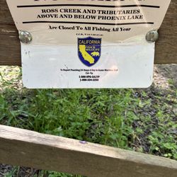
Bon Tempe Lake is located in the Mt Tamalpais watershed area. It can be easily accessed once you drive through the town of Fairfax and then travel a short distance on Bolinas-Fairfax road. The watershed area has a parking fee of $8 which you can pay via credit card at a self pay kiosk. It's located in a small parking area to your right once you drive by the entrance booth (there is sometimes a ranger there who can give information but not take payment.) It's a less crowded area than driving further to the Cataract Falls trailhead, yet still allows for a variety of hiking options from easy to moderate to harder. I come here to embark from one of my favorite loop trails which is over the Bon Tempe Dam, along the Kent trail which takes you to the shores of Alpine Lake, up Stocking Trail to the Rocky Ridge Fire road which leads you back down to the Bon Tempe lake area. Those trails are all within Mt Tamalpais state park but it's nice to be able to access them from this area. Bon Tempe lake is a peaceful lake with its own trail that you can do a loop around if you prefer not to climb up the harder mountain trails. Fishing is allowed in some areas and the trails have a beautiful array of wildflowers in the spring. In the drought prone Bay Area, the appeal of this area is to see some type of water feature - even though nearby Alpine Lake was shockingly low this week (05/22/21) Love embarking on hikes from this area and afterwards, there's plenty of local dining options when you drive back through Fairfax. Review #28 of 100 review goal in 2021

One of the best locations for many great trails! The best way to get here is going to the 'Mt Tamalpais Watershed' where you pay an $8 parking fee. There is no attendants but a pay machine that you can pay cash or card. Very convenient. There is a porta-potty if you have to go. Unfortunately, there is no available map for your use. I would suggest to use the 'AllTrails' to know where you are going. There is plenty of parking even on a weekend but the parking is on gravel. This lake is on the other side of 'Apline Lake'. The trail we took, took us to both. Actually, the trail we took was the 'Kent trail' to 'Stockings Trail'. This was an awesome trail to take, about 5 miles loop. It takes you to many small waterfalls and rivers, big trees, large logs, bridges and stairs were killer! Don't come here if you've partied the night before. I totally regret it as it was killer on my body! Hahaha... Some trails can be deceiving but you have to go through rocks, bridges and water beds so make use of those waterproof hiking shoes! Because of the waterfalls, water puddles and lake, beware of ticks! There is a lots of them but you can avoid by wearing long pants and socks if you can. Check your clothes before entering your car. Most of the trail is shaded but towards the end was open space. Many of the trails are very narrow for one person. I believe this is one of the most beautiful most scenic trails I have gone through so far. I would definitely come back here to do it again! It's a great workout! The lake is beautiful and pictures don't do justice compared to being there. [38/100]


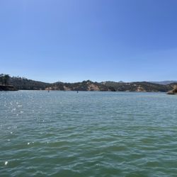
Bon Tempe is the lake that is visible looking out from the East Peak of Mt Tam. To walk around the whole lake is around 4 miles and a little under 2 hours. It's is more of a walk than a hike but there are numerous trails around that can give you more incline like taking Fish Grade to Phoenix Lake which is around 2 miles one way. What I like about Bon Tempe is that half of it is very sunny and the other half is very shaded so you get the best of both worlds. There are small little rocky beaches along the walk if you want to sit and look out at the lake but unfortunately swimming is forbidden though fishing okay with a permit in selected areas. It's very quiet here, it's a nice place to meditate or be able to listen to nature. To get there take the Sky Oaks road and park the same place you would for Lake Lagunitas or you could veer off on Bon Tempe Road which takes you near the damn. I don't like this road as much because it's a dirt road with rocks that is harder on the tires but this road is better if just there for fishing near the damn.

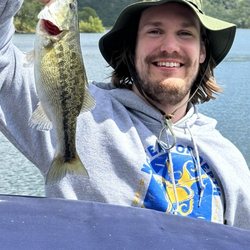
I've come here 3 different times to go fishing, and each time I went home empty-handed. Boo hoo, right? But I'll say this... if you're gonna go fishing and not catch any fish, I can't think of a more scenic place to do it than Bon Tempe Lake. The lake/park is just a 10-minute drive up the hill from downtown Fairfax. Once you arrive in the parking lot, you feel like you're in another country (think "Sound of Music" meets "A River Runs Through It"). This is nature at its finest. The whole area is beautifully manicured and pristine. You won't see litter or cigarette butts on these grounds. There are plenty of options to set up your fishing pole. And they stock the lake monthly with fresh trout. Even though my fishing buddy and I have been 0-3 on catching anything, we always have a wonderful time soaking in the tranquil surroundings. If you're not into fishing, you can come here to jog, hike, picnic, etc. Even dogs are welcome (as long as they are on a leash). Everyone is welcome. Though keep in mind, the rangers will check to see if you have your fishing license (so be prepared). I don't care if I ever catch a fish at Bon Tempe, because at the end of the day, I always drive away from here with lovely memories and peace of mind.

Bon Tempe is one of the many trailheads around the base of the sexy little vixen that is Mt. Tam in Marin County. There's no real incline or difficult patches, it's just a whole lot of lush forest area to keep you company and some water-y things (dams, rivers, basins) that no doubt keep the area so lush. You can fish in designated areas, but be mindful of the signs as some of the water areas are a drinking water source, so steer clear of bathing in them or letting your four-legged friend loose. I saw a couple people jogging the same path I was on and then a couple in regular clothes/flip flops, so I'm thinking it's pretty much a "hike" that is what you make of it. We were only supposed to do a 3-mileish hike, but ended up not looping where we should have and ended up walking a brisk 6.9 miles instead. I would have preferred the 3-mile course, as again, there was no intensity keeping my intrigue and after awhile, stopping to smell the nonexistent roses just gets annoying! The gent's review that has the directions to the base of this trailhead is pretty on point.
")
This lake is a great destination for a shorter trip into Marin. The paths north of the lakes are sunny, while the southern paths are shady, so you can find the right temp for you based on the day's weather. It's right next to Fairfax, for a bite to eat afterwards either at one of the many restaurants or the amazing all-organic grocery store Good Earth. Cataract Falls and Carson Falls are both beautiful sights in the mid-south and western portions of the park respectively.

4 years ago
This is actually just one of several reservoirs that make up the Mount Tamalpais Watershed. There are also creeks and a dam that add to the features. One of the main roads to get up there is just above the town of Fairfax in Marin County. It is a windy road but short, like 10 minutes or so. There are also a lot of bikers who like this area, so watch out on those narrow roads. Once you get closer to the park, the pavement stops and you will have to drive on large gravel for quite a bit, so don't be bringing your high end luxury car here. Lol Once there, an $8 parking fee through a kiosk awaits. I did a 6 mile loop starting at the dam and starting on Alpine lake. Easy start for the first mile or so, with most of it being lakeside. Then the middle 3 miles goes deeper into the forest cover and is more strenous, a constant climb that will speed up the heart rate. Love doing this amongst forest air. Deep in city confines...not so much. The descend will bring you back to where Alpine Lake and Bon Tempe Lake meets, by the dam. The top of hike is exposed and rocky but still gorgeous. Actually reminded me a bit of Tahoe with rocky trails and exposed blue skies. There will be a view of the lower elevations of Southern Marin County. There will also be many glimpses of neighboring Mt. Tam. And after that great morning workout, I was able to have a nice relaxing outdoor meal at one of the many charming independent restaurants in Fairfax, just 10 minutes down the road. Great way to start my stay-cation. read more

A post on NextDoor.com caught my attention. Someone had just moved to the neighborhood and was asking how they could hike without paying the $8 parking fee they'd noticed in some areas. The deluge of responses made it clear: if you're paying to park in Marin County, you're doing something wrong. With only a single exception in memory, I don't think I've paid to hike anywhere in the county and these days all I do is hike. But, if you want to hike the grounds of the Mount Tam Watershed it is true that there's a $8 cost to that. You can get around this by purchasing an annual parking pass or checking a pass out from the Marin County Library system. Bon Tempe Lake is my favorite hike within this area of the Mt. Tam Watershed. With an easy to follow, well-trod, 4.8 mile path around the lake's perimeter, and situated only minutes from downtown Fairfax, Bon Tempe is a quintessential Marin experience. You're in nature, beside a gorgeous, placidly serene lake yet only 10 minutes from a good brunch or latte. There's nothing difficult about the hike around the lake and though it isn't flat, it's elevations are quite gentle. If you need more, add a loop around Lake Lagunitas (the two paths intersect) to increase your hike by another 1.2 miles. Fishing is allowed here (but no swimming) and the parking area - for Bon Tempe in particular - fills up early on weekends. All the more reason to make time for Bon Tempe on a weekday. There's lots of hiking options here in the Watershed but for my money, the half-shaded-half-sunny path around Bon Tempe is the loveliest of them all. read more

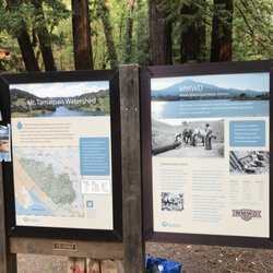
This lake is one of the reservoirs in the Mount Tamalpais Watershed. There are about seven reservoirs that were formerly part of Lagunitas Creek, which now form the main water supply for southern Marin County. The Marin Municipal Water District was actually the very first water district in the entire State of California. It's really a fascinating history. If you have a chance, go visit the Pine Mountain tunnel. 100 years ago, miners blasted a long tunnel through Pine Mountain. Hard to imagine! They have sealed the eastern end of the pipe, but you can still go up there and visit. There's hardly any more dynamiting going on anymore, so it's pretty safe. I love to bike around the Lakes. I start usually at Natalie Coffin Greene Park in Ross, and then bike on from there. I usually take Shaver grade up and come down on Sky Oaks Boulevard. From there I like to go to the Filter Plant Road, which is a pleasant downhill. As others have noted, this is one of the most beautiful areas in the entire San Francisco Bay Area. All of the lakes are absolutely gorgeous. Keep in mind that on the weekends it can be extremely busy and tough to get a parking spot. Today, I came on a midweek morning and had no trouble whatsoever. read more


Took an insane 12 mile hike loop past Bon Tempe Lake (actually a reservoir) to Alpine Lake and back. I love hiking here because the paths here can take you from a lake paths to wooded areas, river streams, flowing waterfalls, flooded marsh areas, maintained grass meadows, overgrown and waist high grain stalks to vistas and back- all on one hike. It's such an amazing display of nature. Overall the paths are well marked, have a ton of visitors, and trails are worn and easy to follow. There can be a little scrambling on certain trails but you usually see where trails continue easily. There are a lot of trails with lots of various lengths for every kind of hiker. If you visit, make sure you bring cash to help pay for parking and make sure you follow your map or hiking guide. It's easy to get lost. read more


3 years ago
5 years ago
Bon Tempe Lake is located in the Mt Tamalpais watershed area. It can be easily accessed once you drive through the town of Fairfax and then travel a short distance on Bolinas-Fairfax road. The watershed area has a parking fee of $8 which you can pay via credit card at a self pay kiosk. It's located in a small parking area to your right once you drive by the entrance booth (there is sometimes a ranger there who can give information but not take payment.) It's a less crowded area than driving further to the Cataract Falls trailhead, yet still allows for a variety of hiking options from easy to moderate to harder. I come here to embark from one of my favorite loop trails which is over the Bon Tempe Dam, along the Kent trail which takes you to the shores of Alpine Lake, up Stocking Trail to the Rocky Ridge Fire road which leads you back down to the Bon Tempe lake area. Those trails are all within Mt Tamalpais state park but it's nice to be able to access them from this area. Bon Tempe lake is a peaceful lake with its own trail that you can do a loop around if you prefer not to climb up the harder mountain trails. Fishing is allowed in some areas and the trails have a beautiful array of wildflowers in the spring. In the drought prone Bay Area, the appeal of this area is to see some type of water feature - even though nearby Alpine Lake was shockingly low this week (05/22/21) Love embarking on hikes from this area and afterwards, there's plenty of local dining options when you drive back through Fairfax. Review #28 of 100 review goal in 2021 read more


One of the best locations for many great trails! The best way to get here is going to the 'Mt Tamalpais Watershed' where you pay an $8 parking fee. There is no attendants but a pay machine that you can pay cash or card. Very convenient. There is a porta-potty if you have to go. Unfortunately, there is no available map for your use. I would suggest to use the 'AllTrails' to know where you are going. There is plenty of parking even on a weekend but the parking is on gravel. This lake is on the other side of 'Apline Lake'. The trail we took, took us to both. Actually, the trail we took was the 'Kent trail' to 'Stockings Trail'. This was an awesome trail to take, about 5 miles loop. It takes you to many small waterfalls and rivers, big trees, large logs, bridges and stairs were killer! Don't come here if you've partied the night before. I totally regret it as it was killer on my body! Hahaha... Some trails can be deceiving but you have to go through rocks, bridges and water beds so make use of those waterproof hiking shoes! Because of the waterfalls, water puddles and lake, beware of ticks! There is a lots of them but you can avoid by wearing long pants and socks if you can. Check your clothes before entering your car. Most of the trail is shaded but towards the end was open space. Many of the trails are very narrow for one person. I believe this is one of the most beautiful most scenic trails I have gone through so far. I would definitely come back here to do it again! It's a great workout! The lake is beautiful and pictures don't do justice compared to being there. [38/100] read more


5 years ago
This is such a beautiful trail to hike. It's about 4 miles around the lake. Its clean and a relatively easy hike. Lots of trees and shade! It's dog friendly. Don't forget to pay for parking, $8.00 read more


4 years ago
3 years ago
Bon Tempe is the lake that is visible looking out from the East Peak of Mt Tam. To walk around the whole lake is around 4 miles and a little under 2 hours. It's is more of a walk than a hike but there are numerous trails around that can give you more incline like taking Fish Grade to Phoenix Lake which is around 2 miles one way. What I like about Bon Tempe is that half of it is very sunny and the other half is very shaded so you get the best of both worlds. There are small little rocky beaches along the walk if you want to sit and look out at the lake but unfortunately swimming is forbidden though fishing okay with a permit in selected areas. It's very quiet here, it's a nice place to meditate or be able to listen to nature. To get there take the Sky Oaks road and park the same place you would for Lake Lagunitas or you could veer off on Bon Tempe Road which takes you near the damn. I don't like this road as much because it's a dirt road with rocks that is harder on the tires but this road is better if just there for fishing near the damn. read more

I've come here 3 different times to go fishing, and each time I went home empty-handed. Boo hoo, right? But I'll say this... if you're gonna go fishing and not catch any fish, I can't think of a more scenic place to do it than Bon Tempe Lake. The lake/park is just a 10-minute drive up the hill from downtown Fairfax. Once you arrive in the parking lot, you feel like you're in another country (think "Sound of Music" meets "A River Runs Through It"). This is nature at its finest. The whole area is beautifully manicured and pristine. You won't see litter or cigarette butts on these grounds. There are plenty of options to set up your fishing pole. And they stock the lake monthly with fresh trout. Even though my fishing buddy and I have been 0-3 on catching anything, we always have a wonderful time soaking in the tranquil surroundings. If you're not into fishing, you can come here to jog, hike, picnic, etc. Even dogs are welcome (as long as they are on a leash). Everyone is welcome. Though keep in mind, the rangers will check to see if you have your fishing license (so be prepared). I don't care if I ever catch a fish at Bon Tempe, because at the end of the day, I always drive away from here with lovely memories and peace of mind. read more

7 years ago
7 years ago
Bon Tempe is one of the many trailheads around the base of the sexy little vixen that is Mt. Tam in Marin County. There's no real incline or difficult patches, it's just a whole lot of lush forest area to keep you company and some water-y things (dams, rivers, basins) that no doubt keep the area so lush. You can fish in designated areas, but be mindful of the signs as some of the water areas are a drinking water source, so steer clear of bathing in them or letting your four-legged friend loose. I saw a couple people jogging the same path I was on and then a couple in regular clothes/flip flops, so I'm thinking it's pretty much a "hike" that is what you make of it. We were only supposed to do a 3-mileish hike, but ended up not looping where we should have and ended up walking a brisk 6.9 miles instead. I would have preferred the 3-mile course, as again, there was no intensity keeping my intrigue and after awhile, stopping to smell the nonexistent roses just gets annoying! The gent's review that has the directions to the base of this trailhead is pretty on point. read more


14 years ago
10 years ago
This lake is a great destination for a shorter trip into Marin. The paths north of the lakes are sunny, while the southern paths are shady, so you can find the right temp for you based on the day's weather. It's right next to Fairfax, for a bite to eat afterwards either at one of the many restaurants or the amazing all-organic grocery store Good Earth. Cataract Falls and Carson Falls are both beautiful sights in the mid-south and western portions of the park respectively. read more
 - Hiking Near Me - Fairfax, California")
8 years ago
7 years ago
9 years ago
Trails are not maintained at all (poison oak and scotch broom everywhere on trail)...warning: you will get ticks here! The picture is from the parking lot this morning-- human feces!!! This is the 3rd time this month that I've observed this revolting aftermath. For $8, trails and parking lots should be maintained!! read more

15 years ago
More info about Bon Tempe Lake
Sky Oaks Rd
Fairfax, CA 94978
Directions
Hours
Outdoor Amenities
Ask the Community - Bon Tempe Lake
Review Highlights - Bon Tempe Lake
You might also consider


Bon Tempe Lake - hiking - Updated July 2026
Best of Fairfax
People found Bon Tempe Lake by searching for…
Trending Searches in Fairfax, CA
Beautiful Views near Bon Tempe Lake
Blueberry Picking near Bon Tempe Lake
Boat Launch near Bon Tempe Lake
Boat Tours near Bon Tempe Lake
Cliff Jumping near Bon Tempe Lake
Cruising Spots near Bon Tempe Lake
Dog Friendly Trails near Bon Tempe Lake
Fishing Rental near Bon Tempe Lake
Jet Ski Rental near Bon Tempe Lake
Kayak Rental near Bon Tempe Lake
Kids Activities Indoor near Bon Tempe Lake
Lakes & Ponds near Bon Tempe Lake
Off Road Trails near Bon Tempe Lake
Outdoor Activities near Bon Tempe Lake
Outdoor Basketball Courts near Bon Tempe Lake
Parks For Parties near Bon Tempe Lake
Peach Picking near Bon Tempe Lake
Picnic Spots near Bon Tempe Lake
Places To Swim near Bon Tempe Lake
Places To Walk Around near Bon Tempe Lake
Pontoon Boat Rentals near Bon Tempe Lake
Private Boat Charters near Bon Tempe Lake
Public Shower near Bon Tempe Lake
River Swimming near Bon Tempe Lake
River Tubing near Bon Tempe Lake
Rock Quarry near Bon Tempe Lake
Scenic Drive near Bon Tempe Lake
Scenic Night View near Bon Tempe Lake
Scenic Overlook near Bon Tempe Lake
Scenic Restaurants near Bon Tempe Lake
Soccer Store near Bon Tempe Lake
Splash Pad near Bon Tempe Lake
Sunrise View near Bon Tempe Lake
Sunset Cruise near Bon Tempe Lake
Swimming Holes near Bon Tempe Lake
Swimming Lakes near Bon Tempe Lake
U Pick Farms near Bon Tempe Lake
View Points near Bon Tempe Lake
Watch Sunset near Bon Tempe Lake
Water Parks near Bon Tempe Lake
Water Parks For Kids near Bon Tempe Lake
Browse Nearby
BEST of Fairfax, California Coffee near Bon Tempe Lake
BEST of Fairfax, California Restaurants near Bon Tempe Lake
BEST of Fairfax, California Things to Do near Bon Tempe Lake
BEST of Fairfax, California Parks near Bon Tempe Lake
BEST of Fairfax, California Breakfast near Bon Tempe Lake
Browse Brands
Related Searches in Fairfax, CA
Affordable Fishing Rental Services in Fairfax, California
Affordable Kayak Rental Services in Fairfax, California
Best Crabbing Locations to Visit in Fairfax, California
Best Dog Hiking Trails Around Fairfax, California
Best Fishing Locations and Guides in Fairfax, California
Best Nature Trails for Hiking in Fairfax, California
Best Parks for Parties and Events in Fairfax, California
Best Places for Horseback Riding in Fairfax, California
Best Sightseeing Experiences Available in Fairfax, California
Best Waterfalls and Swimming Holes in Fairfax, California
Book Top Fishing Charters in Fairfax, California Today
Book Top Fishing Trips in Fairfax, California Today
Check Out Off Road Trails in Fairfax, California
Discover Dog Friendly Trails to Explore in Fairfax, California
Discover Easy Hiking Trails Near Fairfax, California
Discover Kid Friendly Hiking Trails in Fairfax, California
Discover Lakes & Ponds to Explore in Fairfax, California
Discover Popular Bike Trails in Fairfax, California
Discover Top Fishing Lakes in Fairfax, California for Your Next Trip
Discover a Hiking Trail in Fairfax, California
Discover the Best Beaches in Fairfax, California
Discover the Best Fishing Lake in Fairfax, California
Discover the Best Night Hike Trails in Fairfax, California
Discover the Best Sunset Cruise Tours in Fairfax, California
Dog-Friendly Hikes With Dogs in Fairfax, California
Enjoy Camping Adventures Around Fairfax, California
Enjoy Fishing Pier Spots in Fairfax, California With Scenic Views
Enjoy Fishing With Kids in Fairfax, California Safely
Enjoy Hiking Adventures in Fairfax, California
Enjoy Kayaking Adventures in Fairfax, California
Enjoy Off Leash Dog Hikes in Fairfax, California
Enjoy Sailing Adventures in Fairfax, California
Enjoy Scenic Places to Walk in Fairfax, California
Enjoy Water Activities and Fun in Fairfax, California
Enjoy Whale Watching Experiences in Fairfax, California
Enjoy a Beautiful Waterfall Hike in Fairfax, California
Enjoy the Best Walking Path in Fairfax, California
Enjoy the Best Walking Trails in Fairfax, California
Experience Deep Sea Fishing Adventures in Fairfax, California
Experience Thrilling Parasailing Adventures in Fairfax, California
Experienced Fishing Guides Available in Fairfax, California
Explore Beautiful Parks and Green Spaces in Fairfax, California
Explore Boat Rentals for Every Need in Fairfax, California
Explore Easy Hikes Perfect for All in Fairfax, California
Explore Fun Activities to Do in Fairfax, California
Explore Parks With Lakes to Visit in Fairfax, California
Explore Popular Boat Charters Near Fairfax, California
Explore Popular Campgrounds Near Fairfax, California