
Mt Pisgah Conservation Area Photos


You might also consider
More like Mt Pisgah Conservation Area
Recommended Reviews - Mt Pisgah Conservation Area
Start your review...

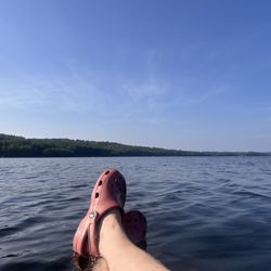
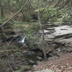
I feel the need to preface all of my nature reviews with this: being 90% forested and having around 3500 miles of coastline, Maine (and NH) has a tremendous amount of spaces, walkways, paths, and trails of all kinds and of all levels. There's something for everyone. What I'm reviewing is how a spot compares to similar outdoor spots in my personal opinion. Being in nature - and remembering to carry in, carry out - is always five stars! :) Parking? Yes. Loop trail? Yes. Well marked signs? Yes. Element of surprise? Yes. This is a gem of a hike. And it's proof that just when you think you know Maine... you don't. Will I ever run out of incredible places to explore here? Mt Pisgah proves I won't. I had never heard of this spot before, but was doing research for somewhere to play outside near the Augusta area, and this came up. It was everything I was looking for: 2 to 4 miles, meandering through the forest, and absolutely outstanding views at the top. I took Blueberry Trail (1.3 miles) which was mostly a very windy path through woodlands; what makes it so special, though, is the wild blueberries that grow near the top. From the informational sign: "...In natural settings native highbush blueberries are typically found in areas with wet, acidic, organic soils. Mt Pisgah, where highbush blueberries occur, does not resemble these preferred habitats. At this site, the highbush blueberries are found in an upland forest with dry soil and no nearby water source. It is unclear how the highbush blueberries came to be in this less than ideal habitat." TLDR: There are magical blueberries here. When I reached the top I climbed up the historic fire tower for impressive 360 degree views of the surrounding area. To come down from the summit there are two options: Tower Trail (which is about .7 miles) which passes through rich forest (expect lots of wooden planks over streams) OR the access road which is a straight shot on a well groomed, relatively accessible (think stroller-friendly) road back up and back from the parking lot. Side note: Ledges Trail, 1.4 miles, adds steps but not views. (From the informational sign at the top of the mountain: "In Hebrew, Pisgah means a lookout or place with a view, and refers to the place on Mt Nebo from which Moses looked out over the promised lands. In the 19th century, before the fire tower was constructed, the summit of Pisgah was an open pasture that provided panoramic views. Mt Pisgah has a rich agricultural history. Old stone walls, second growth pine and hardwood forest, and gnarly sugar maples with tap holes tell the story of intensive land clearing, pasturing, cultivation, and farm abandonment.") read more


3 years ago
More info about Mt Pisgah Conservation Area
Mt Pisgah Rd
Winthrop, ME 04364
Directions
Visit Website
https://www.tklt.org/pisgah
Hours
Outdoor Amenities


Mt Pisgah Conservation Area - hiking - Updated July 2026
Best of Winthrop
People found Mt Pisgah Conservation Area by searching for…
Hiking Trails With Waterfalls in Winthrop, ME
Lookout Points in Winthrop, ME
Walking Trails in Winthrop, ME
Places to Take Pictures in Winthrop, ME
Scenic Overlook in Winthrop, ME
Beautiful Views in Winthrop, ME
Swimming Lakes in Winthrop, ME
Running Trails in Winthrop, ME
Fun Things to Do With Teens in Winthrop, ME
Trending Searches in Winthrop, ME
Day Trips near Mt Pisgah Conservation Area
Dog Friendly Beaches near Mt Pisgah Conservation Area
Dog Friendly Trails near Mt Pisgah Conservation Area
Indoor Attractions near Mt Pisgah Conservation Area
Kayak Rental near Mt Pisgah Conservation Area
Kids Activities Outdoor near Mt Pisgah Conservation Area
Lakes & Ponds near Mt Pisgah Conservation Area
Outdoor Activities near Mt Pisgah Conservation Area
Outdoor Movies near Mt Pisgah Conservation Area
Peach Picking near Mt Pisgah Conservation Area
Picnic Spots near Mt Pisgah Conservation Area
Places To Swim near Mt Pisgah Conservation Area
Pool Day Pass near Mt Pisgah Conservation Area
Public Beaches near Mt Pisgah Conservation Area
Public Shower near Mt Pisgah Conservation Area
River Swimming near Mt Pisgah Conservation Area
Scenic Overlook near Mt Pisgah Conservation Area
Secluded Spots near Mt Pisgah Conservation Area
Sunrise View near Mt Pisgah Conservation Area
Swimming Holes near Mt Pisgah Conservation Area
Browse Articles
Browse Nearby
Browse Brands
Related Searches in Winthrop, ME
Affordable Kayak Rental Services in Winthrop, Maine
Best Dog Hiking Trails Around Winthrop, Maine
Best Fishing Locations and Guides in Winthrop, Maine
Best Fun Things to Do in Winthrop, Maine
Best Parks for Parties and Events in Winthrop, Maine
Best Places for Horseback Riding in Winthrop, Maine
Best Water Parks for Kids in Winthrop, Maine
Best Waterfalls and Swimming Holes in Winthrop, Maine
Check Out Great Playgrounds in Winthrop, Maine
Discover Baseball Fields Around Winthrop, Maine
Discover Dog Friendly Beaches Near Winthrop, Maine
Discover Dog Friendly Trails to Explore in Winthrop, Maine
Discover Fun Activities to Do in Winthrop, Maine
Discover Lakes & Ponds to Explore in Winthrop, Maine
Discover Popular Photo Spots in Winthrop, Maine
Discover Top Nature Parks to Visit in Winthrop, Maine
Discover a Hiking Trail in Winthrop, Maine
Discover the Best Beaches in Winthrop, Maine
Discover the Best Night Hike Trails in Winthrop, Maine
Discover the Best Running Track in Winthrop, Maine
Dog-Friendly Hikes With Dogs in Winthrop, Maine
Enjoy Hiking Adventures in Winthrop, Maine
Enjoy Off Leash Dog Hikes in Winthrop, Maine
Enjoy the Best Walking Trails in Winthrop, Maine
Experience Stunning Sunset Views in Winthrop, Maine
Explore Beautiful Parks and Green Spaces in Winthrop, Maine
Explore Easy Hikes Perfect for All in Winthrop, Maine
Explore Free Picnic Areas Around Winthrop, Maine
Explore Free Things to Do Around Winthrop, Maine
Explore Fun Activities to Do in Winthrop, Maine
Explore Picnic Parks Near Winthrop, Maine
Explore Popular Campgrounds Near Winthrop, Maine
Explore Popular Picnic Areas Around Winthrop, Maine
Explore Popular RV Parks Around Winthrop, Maine
Explore Popular Scenic Overlook Points in Winthrop, Maine
Explore Popular State Park Destinations in Winthrop, Maine
Explore Popular View Points Around Winthrop, Maine
Explore Scenic Lakes to Visit in Winthrop, Maine
Explore Secret Spots Worth Visiting in Winthrop, Maine
Explore Top Dog Parks in Winthrop, Maine Near You
Explore Top Gyms in Winthrop, Maine Now
Explore Top Water Parks in Winthrop, Maine Today
Explore Venues & Event Spaces in Winthrop, Maine
Explore the Best Swimming Holes Around Winthrop, Maine
Family Friendly Hiking With Kids in Winthrop, Maine
Find Beautiful Views in Winthrop, Maine
Find Great Places to Feed Ducks in Winthrop, Maine
Find Top Dog Friendly Parks to Visit in Winthrop, Maine
Find Top Skate Parks in Winthrop, Maine for All Skill Levels
People who viewed Mt Pisgah Conservation Area also viewed
Vaughan Woods
12 reviews
Vassalboro Town Forest Trail
1 review
Jones-Bonney Turner Village Park
1 review
Annie Sturgis Sanctuary
1 review
David Rancourt River Preserve
1 review
Peacock Beach
5 reviews
J. Eugene Boivin Park
1 review
Shepard’s Farm Family Preserve
1 review
Winthrop Beach
9 reviews
Creative Recreations
2 reviews