Old Hancock Trail Photos


You might also consider


More like Old Hancock Trail
Recommended Reviews - Old Hancock Trail
Start your review...



4 years ago
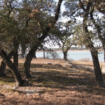
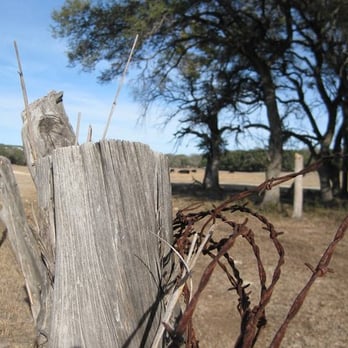
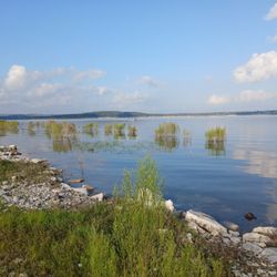
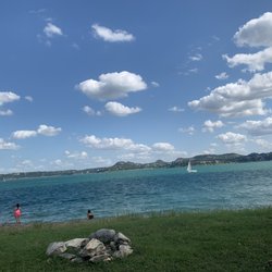
This review is targeting active adults who love the outdoors and like to run, hike, or cycle (mountain bike) on trails with a variety of terrain: grassland, limestone rock gardens, oak groves, and lake shoreline. If that doesn't float your boat, or you are looking for a spot to have a family swim & picnic with the kids, knock the stars down to 2 and find another pretty park to explore during your visit to North Canyon Lake. Old Hancock Equestrian Trail is a free, public, day-use-only park on land managed by the U.S. Army Corps of Engineers, like all the other land in the flood plain surrounding Canyon Lake. It is designated specifically for horseback riding, so everyone else must yield to those riders. If you get there before 9a on a weekday, chances are, you'll have the whole place to yourself for a 7-mile round-trip (out and back) trip from the trailhead around the north shore of the lake to Canyon Park Road (near Brookshire Brothers and Canyon Beach). The horses are more commonly seen on the weekends but may be there at any time, along with their owners' trucks and trailers in the dirt parking area. Just off the parking area, there are a few spurs that take you through the bushes to the lakeshore. This area is often used by anglers and kayakers to access the lake during good conditions for their sport, but its main purpose is for horses and their riders to take a dip after their ride. Toward the northeast from the parking area is the main trailhead, next to the informational kiosk. Take the path in the grass that heads north/northeast and follows the shore of the lake. About half the time, you'll have a water view; other times, it will be tall grasses, trees, or cow pastures. Depending on the time of day and time of year, you'll see a variety of birds, insects, deer, cattle, and maybe a big spiny lizard, a snapping turtle, or a harmless rat snake if you're lucky. In the spring, wildflowers and butterflies are abundant, but so can be the mud. In summer, it is hotter than Hades but the lake breeze is nice with the blue water and blue skies. In the fall, a few of the trees take on a magnificent red, orange, and yellow color scheme. In winter, everything is dried out and gray. I just love watching the seasons change here. At different points along the trail, you'll find rest benches, trail markers, and spurs down to the water, where you are welcome to go for a swim (at least at the time of this writing in June 2022). It's one of the last places around Canyon Lake where you can do that without paying a fee, but you've got to want it bad enough to hike there & back, and you can only bring what you can carry on your back. The trail (more like a dual-track dirt road) is mostly flat and open with sand, grass, or caliche surfaces, but there are a few challenging sections with short inclines, yards of bumpy rocks, and a couple of wet weather creek crossings. After a rain, there's also the possibility that some local dude from the adjacent neighborhood will have gone "night muddin'" out there in a 4x4 and made the ruts deep in some areas, but this has lately not been such a problem since the Comal County Sherriff has started warning about the potential $5,000 fine for using a motorized vehicle on the trail. A few words of warning: - This park property is between private land (residences, ranches, and businesses) and the lake. Be sure to stay on the trail and don't trespass over fences or beyond posted "private property" areas. - Shade is limited and the sun can be intense at least 10 months of the year, so wear a hat and sunscreen, make sure you're hydrated, go with a buddy, and try to time your trip for hours close to sun up or sundown. It would not be easy for an emergency vehicle to reach you out there if heatstroke happened. - No restrooms, water fountains, or trash bins are available to users of this trail. Pack in and pack out everything. Leave no trace. Litterbugs, shoo, stay away! read more


18 years ago
The Old Hancock Trail is primarily a trail for horses, but it also makes a good hiking trail. If it is warm outside, beware because there is lots of sunshine on this trail and little shade. Investing in some SPF 40 might be a good idea. It is mostly a dirt trail that skirts the northern side of the lake and stretches for about 3 1/2 miles to end at Canyon Park. To find the trailhead, just find your way to FM 306 (I took FM 12 out of San Marcos and it was a scenic drive). Once you pass FM 3424 on the north side of the lake, continue for about 1.9 miles on FM 306 until you see a street sign for Hancock Road. This road passes by a small airport and then dead ends at the trailhead where there is tons of free parking. Take a picnic with you and maybe a swimsuit, because there are several places along the trail that would be a good stop for a swim and a bite to eat. I mostly felt like I was hiking on someone's ranch road that happened to be next to a nice lake. I saw several deer and birds along the way, and there were a few people on horseback also. I'm sure this trail would be full of wildflowers and butterflies in the Spring. Anyway, I hope this encourages you to check it out when you have a free day to play in the sun. I'm not sure how Yelp ended up with this in Lubbock, but don't worry, I am working with them to fix this error. Yes, it is on Canyon Lake. Google Maps must hate Canyon Lake for some reason. :-) read more



8 years ago

14 years ago
More info about Old Hancock Trail

















Old Hancock Trail - hiking - Updated September 2026
Best of Canyon Lake
People found Old Hancock Trail by searching for…
Swimming Holes in Canyon Lake, TX
Scenic Drive in Canyon Lake, TX
Swimming Lakes in Canyon Lake, TX
Fishing Spots in Canyon Lake, TX
Hot Springs in Canyon Lake, TX
Off Road Trails in Canyon Lake, TX
Dog Swimming in Canyon Lake, TX
Hiking Trails in Canyon Lake, TX
Beautiful Views in Canyon Lake, TX
River Swimming in Canyon Lake, TX
Running Trails in Canyon Lake, TX
Picnic Spots in Canyon Lake, TX
Walking Trails in Canyon Lake, TX
Mountain Biking in Canyon Lake, TX
Scenic View in Canyon Lake, TX
Free Things to Do in Canyon Lake, TX
Trending Searches in Canyon Lake, TX
Apple Orchards near Old Hancock Trail
Apple Picking near Old Hancock Trail
Barbershop near Old Hancock Trail
Beautiful Views near Old Hancock Trail
Bike Shop near Old Hancock Trail
Boating near Old Hancock Trail
Camping Sites near Old Hancock Trail
Casinos near Old Hancock Trail
Cliff Jumping near Old Hancock Trail
Consignment Shops near Old Hancock Trail
Cruising Spots near Old Hancock Trail
Dog Friendly Things To Do near Old Hancock Trail
Dog Swimming near Old Hancock Trail
Estheticians near Old Hancock Trail
Eyelash Extensions near Old Hancock Trail
Hiking Trails With Waterfalls near Old Hancock Trail
Kids Birthday Party near Old Hancock Trail
Lakes & Ponds near Old Hancock Trail
Makeup Artists near Old Hancock Trail
Middle Schools & High Schools near Old Hancock Trail
Musical Instruments & Teachers near Old Hancock Trail
Off Road Trails near Old Hancock Trail
Picnic Areas near Old Hancock Trail
Places To Take Pictures near Old Hancock Trail
Private Schools near Old Hancock Trail
Public Shower near Old Hancock Trail
Rock Quarry near Old Hancock Trail
Running Trails near Old Hancock Trail
Scenic Night View near Old Hancock Trail
Scenic Overlook near Old Hancock Trail
Sunrise View near Old Hancock Trail
Swimming Holes near Old Hancock Trail
Teeth Whitening near Old Hancock Trail
Volleyball Courts near Old Hancock Trail
Watch Sunset near Old Hancock Trail
Browse Nearby
BEST of Canyon Lake, Texas Coffee near Old Hancock Trail
BEST of Canyon Lake, Texas Restaurants near Old Hancock Trail
BEST of Canyon Lake, Texas Things to Do near Old Hancock Trail
BEST of Canyon Lake, Texas Scenic View near Old Hancock Trail
BEST of Canyon Lake, Texas Parks near Old Hancock Trail
BEST of Canyon Lake, Texas Breakfast near Old Hancock Trail
BEST of Canyon Lake, Texas Campgrounds near Old Hancock Trail
Browse Brands
Related Searches in Canyon Lake, TX
Affordable Horse Boarding Services in Canyon Lake, Texas
Affordable Jet Ski Rental Options in Canyon Lake, Texas
Affordable Kayak Rental Services in Canyon Lake, Texas
Affordable Pony Rental Services Available in Canyon Lake, Texas
Best Dog Hiking Trails Around Canyon Lake, Texas
Best Fishing Locations and Guides in Canyon Lake, Texas
Best Nature Trails for Hiking in Canyon Lake, Texas
Best Places for Horseback Riding in Canyon Lake, Texas
Best Pontoon Boat Rentals Near Canyon Lake, Texas
Best Waterfalls and Swimming Holes in Canyon Lake, Texas
Book Exciting Pony Rides in Canyon Lake, Texas for All Ages
Book Expert Dressage Lessons in Canyon Lake, Texas
Check Out Off Road Trails in Canyon Lake, Texas
Discover Dog Friendly Trails to Explore in Canyon Lake, Texas
Discover Fun Activities to Do in Canyon Lake, Texas
Discover Fun Toddler Parks in Canyon Lake, Texas for Your Little One
Discover Horseback Riding Tours in Canyon Lake, Texas
Discover Kid Friendly Hiking Trails in Canyon Lake, Texas
Discover Lakes & Ponds to Explore in Canyon Lake, Texas
Discover Popular Bike Trails in Canyon Lake, Texas
Discover Scenic Mountain Bike Trails Near Canyon Lake, Texas
Discover Top-Rated Dude Ranch Experiences in Canyon Lake, Texas
Discover a Hiking Trail in Canyon Lake, Texas
Discover the Best Beaches in Canyon Lake, Texas
Discover the Best Night Hike Trails in Canyon Lake, Texas
Dog-Friendly Hikes With Dogs in Canyon Lake, Texas
Enjoy Camping Adventures Around Canyon Lake, Texas
Enjoy Exciting Mountain Biking Adventures in Canyon Lake, Texas
Enjoy Fishing Pier Spots in Canyon Lake, Texas With Scenic Views
Enjoy Hiking Adventures in Canyon Lake, Texas
Enjoy Kayaking Adventures in Canyon Lake, Texas
Enjoy Off Leash Dog Hikes in Canyon Lake, Texas
Enjoy River Tubing Adventures in Canyon Lake, Texas
Enjoy Scenic Places to Walk in Canyon Lake, Texas
Enjoy Stables and Horse Riding Experiences in Canyon Lake, Texas
Enjoy Tent Camping Spots Around Canyon Lake, Texas
Enjoy Thrilling Atv Riding Experiences in Canyon Lake, Texas
Enjoy Water Activities and Fun in Canyon Lake, Texas
Enjoy a Mobile Petting Zoo Experience in Canyon Lake, Texas
Enjoy the Best Tubing Experiences in Canyon Lake, Texas
Enjoy the Best Walking Trails in Canyon Lake, Texas
Explore Beautiful Parks and Green Spaces in Canyon Lake, Texas
Explore Bike Rentals Throughout Canyon Lake, Texas
Explore Boat Rentals for Every Need in Canyon Lake, Texas
Explore Easy Hikes Perfect for All in Canyon Lake, Texas
Explore Family-Friendly Petting Zoos in Canyon Lake, Texas
Explore Free Picnic Areas Around Canyon Lake, Texas


