Old Mill Park and Covered Bridge Photos


More like Old Mill Park and Covered Bridge
Recommended Reviews - Old Mill Park and Covered Bridge
Start your review...

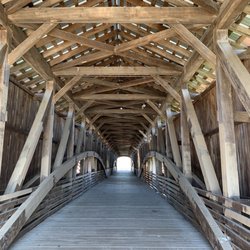
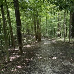
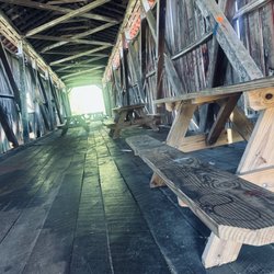
One of the perks of taking day trips when retired is that you find time to explore, discover, and let your mind imagine. So when I decided to explore the covered bridges of Parke County, it wasn't during the peak fall festivals where the traffic is crazy. It was during an off season day where I was the only one on some of the roads. As I worked my way south from Rockville on Bridgeton Road, I was delighted to find this town that seemed like a memorial to days gone by. Arriving from the north, I could see this 245' bridge spanning Big Raccoon Creek. It was by far in the best condition of the bridges I had seen. I realized that this was a reconstruction of a bridge that was originally built in 1868. But after a fire destroyed the original, the folks of the town banded together to rebuild this in 2006. I love that it has windows that you can look through as you walk through the bridge. (The highway now bypasses the bridge for preservation and safety.) There is a mini park next to the bridge (and you can park off the road as well) that you can get a closer look to the dam and waterfall that spans the creek. Seems like a great spot for a picnic! Across the river (south side) is the original Mill which is still functional and has a shop in it where you can pick up the items they have. I, unfortunately, was pressed for time and didn't make it into the mill on this visit. As I drove through town, I could see numerous buildings where the Fall Festival vendors would set up to attract tourists. Seeing all the buildings, I let my imagination run wild and wondered what the town was like before it had the fall festival. What is it like now when the town is filled with visitors? Sounds like another road trip is needed. Review #2731 read more


More info about Old Mill Park and Covered Bridge
Bridgeton, IN 47836
Directions
Hours
Outdoor Amenities


Old Mill Park and Covered Bridge - parks - Updated June 2026
Best of Bridgeton
People found Old Mill Park and Covered Bridge by searching for…
Browse Nearby
BEST of Bridgeton, Indiana Things to Do near Old Mill Park and Covered Bridge
BEST of Bridgeton, Indiana Restaurants near Old Mill Park and Covered Bridge
BEST of Bridgeton, Indiana Pizza near Old Mill Park and Covered Bridge
BEST of Bridgeton, Indiana Shopping near Old Mill Park and Covered Bridge
BEST of Bridgeton, Indiana Campgrounds near Old Mill Park and Covered Bridge
BEST of Bridgeton, Indiana Breweries near Old Mill Park and Covered Bridge