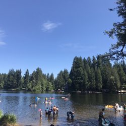
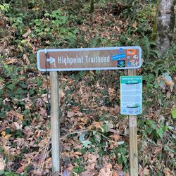
Poo Poo Point - Chirico Trail Photos


You might also consider
More like Poo Poo Point - Chirico Trail
Recommended Reviews - Poo Poo Point - Chirico Trail
Start your review...

Reviews With Photos

A real hike to the top. Not the easiest hike, but far from the hardest and longest. I would say this hike is a nice medium. Even tho it's a fairly quick-medium duration hike the incline will tire you and remind you how important consistent leg days are. When you do finally get to the top the views are nice and there is plenty of space to hang or picnic while you rest before finishing the hike back down. I've taken this hike several times and I can say I got lost my first time and took the wrong, or long way to the top. Theres also a drivable route to the top that the hang gliders use. Yes, they hang glide on this mountain. More than half of my visits I was able to also watch the hang gliders once I got to the top... even crazier, I dont even think that resting area is the true top of the mountain. I don't even. Think ive finished the trail because the gliders rest point is so perfect for stopping and hanging out.

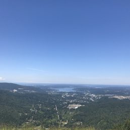
This hike is not for the faint of heart. My husband and I are experienced hikers and thought the hike was easy to moderate. It is very steep, but at a moderate pace with no breaks, it takes only an hour to get to the view of Mt. Rainier/to the kick off spot for paragliders. Fun fact: for about $280 you can actually paraglide from here with an instructor and then land at the bottom near the parking lot. From this point, you turn around, and go for about another 5 minutes and you get the view of Issaquah in front of you and Bellevue in the distance. There are some points in the hike where the path is narrow and you can either get stuck behind some people for a while. I definitely recommend this hike for people who want to get a good workout in. Parking was a hassle, but we only waited 15 minutes to get a spot. There is another parking lot available that is diagonally across the street from this, but it is $5 to park here. If you dont wanna pay, there is also a park parking lot you can park at, but its 2 blocks away from the $5 parking lot.
I'd call it hard-moderate for a hiking trail because the incline is constant the entire time. The trail was pretty dry considering it's February with zero snow on the entire trail- concerning actually since it's February and we've barely had rain. I used hiking poles and super glad I did because the ground is uneven- rocks, roots, and stone steps line the trail the entire way. The trail tends to vary back and forth from being able to pass hikers to single line. There were two adult guys playing with their remote control cars ON the hiking trail which was off putting- play with your toys somewhere else. Also someone had a drone flying when we got to the top- SUPER dangerous since there are paragliders taking off from the top. On the way up the hikers coming back down had fantastic hiking etiquette... pulling off to the side as we were hoofing it up. Every dog we saw on the way up was on a leash which was amazing to see- good job responsible pet owners!! Some people tended to have very loud conversations to we would let them pass to have more peace and quiet. The viewpoint showing Mt. Rainier in all of her glory was spectacular. Again loud conversations and some swearing kinda ruin the mood with nature. We continued on to the viewpoint of Lake Sammamish, downtown Bellevue and Seattle off in the far distance- saw one paraglider take off and thoroughly enjoyed the clear blue skies and sunshine. It was warm hiking on the way up despite the mid to upper 40sF but once you come to both open areas with viewpoints be sure to have layers to pull over because it gets significantly colder and a LOT of wind. At the top we began seeing pet owners who weren't so responsible and at that point saw about 5-6 dogs off leash from the top to the bottom of the trail. One dog off leash even got in a fight with another who was on leash- really explains why you should have your dog on leash. The trail back down can be pretty intense on the legs since it is a continual downward stepwise descent that is unrelenting. Our legs were noodles by the end and we workout on the regular. I'm always dumbfounded by hikers that run down- it seems like it's brutal on the lower body hitting the trail with every step. Hiking poles saved us from face planting into rocks and trees because our legs were tired. There were tons of people heading up the trail as we headed down... hopefully people had water, warm clothes, snacks, and headlamps because we were in the shade heading down and finishing the hike a little after 4pm. Don't do this hike without essentials including plenty of water and layers. Our tiredness also had to do with the extra 1.2 miles we hiked from where we parked (down the road) to the trailhead and back after completing the hike. We hiked around 4.7 miles for the trail with an extra .63 miles each way away from and back to the car. There were four porta potties at the end of the parking lot and two vault toilets at the top of the lookout at the service road which was awesome. Parking at this trail always is horrible because there are completely insufficient spaces for the popularity of the trail. The views from the trail are amazing, the craziness of parking really hinders the hike when you'd like to hike the stated distance- not an extra 1.2 miles parking down the road. If you want to spend $10 there is a parking lot not too far down the road across the street from the trail owned by a resident on their property. It looked like they took Venmo. Overall a lot of bang for your buck with the views and great exercise...my quads, glutes and calves are singing today.
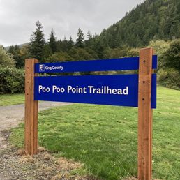
Poo Poo Point is a hike that everyone mentions when you live in Seattle. It is a moderate 4 mile hike that gives you a nice little workout. The elevation is pretty steady the whole way up. The trail is easy to follow and is covered by trees so you can hike even if it's a little rainy. I'd recommend wearing good hiking shoes because of the rocks, but it's definitely doable with good running shoes. The view at the top is beautiful and makes the hike worth it. There is one parking lot right by the trail and the last time I went, there was no parking passes required. The parking lot can get filled pretty quickly on the weekends and if you get there after 8am, it will likely be filled. But there is a school/park that is about a 10 minute walk that you can park at and walk over if the lot is full!

Hike is named due to history communicating with a whistle that sounded like one using the restroom. It's definitely well known and mentioned due to the name as it's memorable and fairly unique (e.g. stands out). The Chirico Trail of this hike is pretty simple, 4 miles through rocky terrain with some annoying mud puddles if there was presence of rain within the past day. Easy to park though and no pass required I believe. This specific trail is a great beginner hike. Maybe even considered just a nice casual hike for conversation but nothing too exciting. It's roughly 4 miles round trip. The views at the top aren't too exciting as you get to overlook Issaquah high school and bits of Bellevue, Sammamish, and a little portion of Seattle. Depending on when you go, you may see gliders which is one of the nicer features with this trail, but not always. There are other viewpoints but there still isn't much to witness.

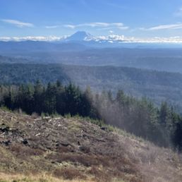
Looking a good spot to enjoy sunrise or sunset??? The top of poo poo pint is your place. This is a popular hike located in Issaquah, WA. I've seen all types of hikers: pros & rookies, runners, children, dogs, people in groups and people walking solo... So basically this trail is for everyone who's willing to go uphill and enjoy a fantastic view. Maybe "moderate"? I'd recommend to get here early enough to find a spot to park (before 8AM) otherwise be ready to wait and wait and wait for a parking spot. Or find an alternative choice nearby and walk (adding a mile to your hike) Officially this is like a 7mile hike but you can make it shorter or longer choosing different routes. There are at least two official trails and two unofficial routes to the top of PooPoo Point. The Chirico Trail: shorter but cuts . 3.8 miles round trip with 2000 feet of elevation gain. NOTE: the word Chirico refers to the creature at the entrance (feline with wings) High School Trail: longer but cuts a few hundred feet of elevation gain off. 7.2 miles round trip with approx 1700 feet of elevation gain. Once you're at top in a clear day you can enjoy the view (Mt Rainier, maple valley, Issaquah, lots of mountains) and see people paragliding. Remember to bring with you water, snacks, and even a hot drink in case is chilly up there (in the winter) Happy Hike!!

What a great trail! I didn't know what to expect when I got out there. I decided to go later in the afternoon. It wasn't crowded at all. Parking is easy. So once I started on my journey I was in hiking heaven. It was so nice to get out and get moving. The trail is pretty narrow in some areas so for sure be careful. Next bring snacks and plenty of water. Towards the top aka finish line there is a place for you to lay out a blanket have picnic, take in the good views and enjoy the atmosphere. It is pretty steep and will have you sweating! But overall great hike for active people. You can also Para Glide: So cool. Your legs will be sore for sure the next day! Pain is gain!

This is the basic bitch hike in the Seattle area. Every Seattleite does this hike because it's a good workout, but is doable for all fitness levels, including beginners. And when I say it's doable, don't expect it to be a walk in the park. There's a good incline to this. But for anyone who likes to hike or wants to like hiking, Poo Poo Point is there for you. Get here early! Get here early! Get here early! I can't emphasize that enough. Because it is the basic bitch hike in the area, everyone visits Poo Poo Point. No matter the time of day it is, especially on weekends, the parking lot is always packed. I arrived here around 6AM, and half of the lot was already full. By the time I was leaving, cars were waiting for hikers to leave. There's also a private parking area across the street that charges you $5, and that also gets full. Otherwise, there is no fee to park here unlike some other trails. It's about four miles round trip. The incline is definitely felt going up, but the reward is when you summit to the spacious grass area where you can see the first lookout to Mount Rainier. It's a beautiful view. And personally, I think it's better than looking out to Issaquah and downtown Bellevue, which is the second lookout. Sorry, you locals. The second lookout is not far from the first lookout, so keep trekking along on the trail. This is where the paragliders take off from, and you can see Issaquah, downtown Bellevue, Lake Samammish, etc. There was also a picnic table. There were restrooms here, but it's closed due to COVID-19. This is a great hike and the best workout in Issaquah! It's accessible with a parking lot right outside of the Chirico Trail, a good climb to the top with a rewarding view and is nearby Front Street, with many restaurants along, to treat yo'self with a beer after burning some cals. Bravo.

We did this hike in early September and really enjoyed the challenging vertical climb with switchbacks and the rewarding view at the top. This hike not only has a beautiful view but equally beautiful is the forest the trail is cut through. It's shaded and offers plenty of relief from the sun and there are several spots with fallen trees or stumps to sit and catch your breath. It is a dog friendly trail and while we didn't have any pups to bring with us, we were sure to be 'those people' and make friends with every dog we passed. At one point my calves were killing me and i didn't think i could take another step, when a chihuahua in its pink dress complete with bow passed me up. So, after being shown up, I pulled it together and made it to the top for a killer view. You can see all the way to Bellevue and a ways beyond on a clear day. Lake Sammamish is even prettier from up above and I90 through Issaquah was jam packed as usual that time of morning and we were grateful to be looking down at it and not in the thick of it like we are the rest of the week. You also can see the jumping off point for the paragliders. I would rate the trail as moderate for difficulty but you can definitely power through it with some breaks. Round trip is about 4 miles and the trail is very well maintained.
If you're a beginner, this is not an easy hike, though it's very rewarding as you can catch the paragliders once at the top. Make sure to have a lot of water and a light snack that you can enjoy once at the peak. Also if you need take some breaks on the way up. It took us about 1.5hrs to go up and 40min to go down. The parking lot is small but there is a private lot across the street for 5$, so bring your cash.

This was my first time here. I got to the designated lot around 930-945am and there were plenty of spots. The trail is rocky or more so the rocks are little step stones to help propel you up. It's a reasonable incline for the majority of the whole hike until it tapers off when you get just around the launch point for the hang/paragliders. It wasn't too tough if you keep a reasonable pace. It's just all uphill. There weren't many flowers blooming as I guess spring has just sprung but there is plenty of greenery to keep you busy. No wildlife either, just pure unadulterated silence. For once, there wasn't someone on the trail playing music on a bluetooth speaker. I will say that the view from the hang gliding launch point is amazing and well worth the hike up. I consider myself an intermediate level hiker and this little hike was just what I needed. Slightly challenging and a great way to push myself. One thing I did find that was unpleasant was that there is a lot of little bags of dog poop along the sides of the trail as well as thrown into the foliage and ground covering. There was also loose/uncollected dog feces on the trail. If you're going to bring a dog, be a responsible dog owner and pick up the poop. It's bad for the trail and wildlife, no one wants to step in your dog's poop, and if you're going to go through the process of picking it up and putting it in a bag then pack it out and leave no trace. There were also a lot of people with dogs not on leashes although there is signage at the parking lot and on the trail to leash your dog. I guess that's pretty commonplace now on the trails as no one seems to really care about the experience of other hikers. There was a girl coming down the trail while I was going up that had freaked out when an unleashed dog presented itself. She told the owner she had a traumatic experience with dogs when she was younger. So I guess just be mindful that not everyone likes dogs. When I got back to the lot around 12-1215pm the parking lot was full.

Great trail in the Issaquah area, with a small parking lot, so recommend getting here early on a weekend if you want to be able to get one of the spaces. Since this isn't a "national park", there is no fee to park or enter, hence its popularity. I started before 8am on a Sunday, and it was already busy in the lot, with no spaces on my descend at 10am. Did the hike on a rainy morning, so the stones, and tree limbs were very slippy, and quite mucky (but that's the best part of a hike, right?!). Definitely a steep hike, so don't do this thinking it's a simple walk. There are essentially 2 peaks, so once you reach the top, keep going 5 more minutes or so, where you will come to the actual peak where the paragliders take flight. Total round trip is close to 4 miles, with around a 1,800ft elevation. Very enjoyable for sure!

It was good hike, it can be rocky at some part, if rain, it will be slippery. The view on clear day is amazing, I could see Mt Rainer. The other view point if u keeping up in the trail, you can see town issaquah with Lake Sammamish. If go early , it should be beautiful sunrise and It would be beautiful sunset.

3 months ago
We've enjoyed hiking here on several occasions. Great for hike with wonderful views. Did this one a couple of Mondays ago. It was foggy initially, but it lifted to reveal Mt. Ranier. But my favorite was as the sun shone through the trees! Highly recommend. Parking does fill up quickly. read more


very beautiful hike! Not too hard on the legs, but steadily goes up in elevation with nice rest stops under the shade. Came out in a very sunny day, so I loved to watch the paragliders flare as they prepared to land. Hard to find where they do that, though, bc hidden behind the big ahh trees lolol ! I gave up after like ( minutes, but at least there are business cards and flyers everywhere at the start point so you can contact them then and there. I like that there is evening seating arrangements at the ground level where you are about to enter or exit from the hike for people to dine. Parking was :/ , though, so had to go to a nearby house where they charged $10. They take cash, Venmo, or Zelle, so thank goodness that there was space there because the lot for this hiking trail is extremely limited! read more

11 months ago
Always a five star hike. A beautiful hike to a gorgeous view. The altitude can be quite challenging so just pace yourself. And the trail can also be very rocky and slippery because of all the rocks. But it's an excellent hike for getting a workout. There is a bathroom at the top but it's stinky. If you start at the Issaquah High School parking lot there is a honey bucket/ portable toilet. And the parking lot here is near a shooting range so don't be alarmed if you hear it. The hike is perfect for keeping in shape. And the view is great when it's clear. And it's a great place to watch the para gliders take off. Do it. And breathe. SYOY! read more


1 year ago
A real hike to the top. Not the easiest hike, but far from the hardest and longest. I would say this hike is a nice medium. Even tho it's a fairly quick-medium duration hike the incline will tire you and remind you how important consistent leg days are. When you do finally get to the top the views are nice and there is plenty of space to hang or picnic while you rest before finishing the hike back down. I've taken this hike several times and I can say I got lost my first time and took the wrong, or long way to the top. Theres also a drivable route to the top that the hang gliders use. Yes, they hang glide on this mountain. More than half of my visits I was able to also watch the hang gliders once I got to the top... even crazier, I dont even think that resting area is the true top of the mountain. I don't even. Think ive finished the trail because the gliders rest point is so perfect for stopping and hanging out. read more


11 months ago
3 years ago
This hike is not for the faint of heart. My husband and I are experienced hikers and thought the hike was easy to moderate. It is very steep, but at a moderate pace with no breaks, it takes only an hour to get to the view of Mt. Rainier/to the kick off spot for paragliders. Fun fact: for about $280 you can actually paraglide from here with an instructor and then land at the bottom near the parking lot. From this point, you turn around, and go for about another 5 minutes and you get the view of Issaquah in front of you and Bellevue in the distance. There are some points in the hike where the path is narrow and you can either get stuck behind some people for a while. I definitely recommend this hike for people who want to get a good workout in. Parking was a hassle, but we only waited 15 minutes to get a spot. There is another parking lot available that is diagonally across the street from this, but it is $5 to park here. If you dont wanna pay, there is also a park parking lot you can park at, but its 2 blocks away from the $5 parking lot. read more


2 years ago
I'd call it hard-moderate for a hiking trail because the incline is constant the entire time. The trail was pretty dry considering it's February with zero snow on the entire trail- concerning actually since it's February and we've barely had rain. I used hiking poles and super glad I did because the ground is uneven- rocks, roots, and stone steps line the trail the entire way. The trail tends to vary back and forth from being able to pass hikers to single line. There were two adult guys playing with their remote control cars ON the hiking trail which was off putting- play with your toys somewhere else. Also someone had a drone flying when we got to the top- SUPER dangerous since there are paragliders taking off from the top. On the way up the hikers coming back down had fantastic hiking etiquette... pulling off to the side as we were hoofing it up. Every dog we saw on the way up was on a leash which was amazing to see- good job responsible pet owners!! Some people tended to have very loud conversations to we would let them pass to have more peace and quiet. The viewpoint showing Mt. Rainier in all of her glory was spectacular. Again loud conversations and some swearing kinda ruin the mood with nature. We continued on to the viewpoint of Lake Sammamish, downtown Bellevue and Seattle off in the far distance- saw one paraglider take off and thoroughly enjoyed the clear blue skies and sunshine. It was warm hiking on the way up despite the mid to upper 40sF but once you come to both open areas with viewpoints be sure to have layers to pull over because it gets significantly colder and a LOT of wind. At the top we began seeing pet owners who weren't so responsible and at that point saw about 5-6 dogs off leash from the top to the bottom of the trail. One dog off leash even got in a fight with another who was on leash- really explains why you should have your dog on leash. The trail back down can be pretty intense on the legs since it is a continual downward stepwise descent that is unrelenting. Our legs were noodles by the end and we workout on the regular. I'm always dumbfounded by hikers that run down- it seems like it's brutal on the lower body hitting the trail with every step. Hiking poles saved us from face planting into rocks and trees because our legs were tired. There were tons of people heading up the trail as we headed down... hopefully people had water, warm clothes, snacks, and headlamps because we were in the shade heading down and finishing the hike a little after 4pm. Don't do this hike without essentials including plenty of water and layers. Our tiredness also had to do with the extra 1.2 miles we hiked from where we parked (down the road) to the trailhead and back after completing the hike. We hiked around 4.7 miles for the trail with an extra .63 miles each way away from and back to the car. There were four porta potties at the end of the parking lot and two vault toilets at the top of the lookout at the service road which was awesome. Parking at this trail always is horrible because there are completely insufficient spaces for the popularity of the trail. The views from the trail are amazing, the craziness of parking really hinders the hike when you'd like to hike the stated distance- not an extra 1.2 miles parking down the road. If you want to spend $10 there is a parking lot not too far down the road across the street from the trail owned by a resident on their property. It looked like they took Venmo. Overall a lot of bang for your buck with the views and great exercise...my quads, glutes and calves are singing today. read more


Poo Poo Point is a hike that everyone mentions when you live in Seattle. It is a moderate 4 mile hike that gives you a nice little workout. The elevation is pretty steady the whole way up. The trail is easy to follow and is covered by trees so you can hike even if it's a little rainy. I'd recommend wearing good hiking shoes because of the rocks, but it's definitely doable with good running shoes. The view at the top is beautiful and makes the hike worth it. There is one parking lot right by the trail and the last time I went, there was no parking passes required. The parking lot can get filled pretty quickly on the weekends and if you get there after 8am, it will likely be filled. But there is a school/park that is about a 10 minute walk that you can park at and walk over if the lot is full! read more


4 years ago
Hike is named due to history communicating with a whistle that sounded like one using the restroom. It's definitely well known and mentioned due to the name as it's memorable and fairly unique (e.g. stands out). The Chirico Trail of this hike is pretty simple, 4 miles through rocky terrain with some annoying mud puddles if there was presence of rain within the past day. Easy to park though and no pass required I believe. This specific trail is a great beginner hike. Maybe even considered just a nice casual hike for conversation but nothing too exciting. It's roughly 4 miles round trip. The views at the top aren't too exciting as you get to overlook Issaquah high school and bits of Bellevue, Sammamish, and a little portion of Seattle. Depending on when you go, you may see gliders which is one of the nicer features with this trail, but not always. There are other viewpoints but there still isn't much to witness. read more


4 years ago
Looking a good spot to enjoy sunrise or sunset??? The top of poo poo pint is your place. This is a popular hike located in Issaquah, WA. I've seen all types of hikers: pros & rookies, runners, children, dogs, people in groups and people walking solo... So basically this trail is for everyone who's willing to go uphill and enjoy a fantastic view. Maybe "moderate"? I'd recommend to get here early enough to find a spot to park (before 8AM) otherwise be ready to wait and wait and wait for a parking spot. Or find an alternative choice nearby and walk (adding a mile to your hike) Officially this is like a 7mile hike but you can make it shorter or longer choosing different routes. There are at least two official trails and two unofficial routes to the top of PooPoo Point. The Chirico Trail: shorter but cuts . 3.8 miles round trip with 2000 feet of elevation gain. NOTE: the word Chirico refers to the creature at the entrance (feline with wings) High School Trail: longer but cuts a few hundred feet of elevation gain off. 7.2 miles round trip with approx 1700 feet of elevation gain. Once you're at top in a clear day you can enjoy the view (Mt Rainier, maple valley, Issaquah, lots of mountains) and see people paragliding. Remember to bring with you water, snacks, and even a hot drink in case is chilly up there (in the winter) Happy Hike!! read more


5 years ago
What a great trail! I didn't know what to expect when I got out there. I decided to go later in the afternoon. It wasn't crowded at all. Parking is easy. So once I started on my journey I was in hiking heaven. It was so nice to get out and get moving. The trail is pretty narrow in some areas so for sure be careful. Next bring snacks and plenty of water. Towards the top aka finish line there is a place for you to lay out a blanket have picnic, take in the good views and enjoy the atmosphere. It is pretty steep and will have you sweating! But overall great hike for active people. You can also Para Glide: So cool. Your legs will be sore for sure the next day! Pain is gain! read more


6 years ago
This is the basic bitch hike in the Seattle area. Every Seattleite does this hike because it's a good workout, but is doable for all fitness levels, including beginners. And when I say it's doable, don't expect it to be a walk in the park. There's a good incline to this. But for anyone who likes to hike or wants to like hiking, Poo Poo Point is there for you. Get here early! Get here early! Get here early! I can't emphasize that enough. Because it is the basic bitch hike in the area, everyone visits Poo Poo Point. No matter the time of day it is, especially on weekends, the parking lot is always packed. I arrived here around 6AM, and half of the lot was already full. By the time I was leaving, cars were waiting for hikers to leave. There's also a private parking area across the street that charges you $5, and that also gets full. Otherwise, there is no fee to park here unlike some other trails. It's about four miles round trip. The incline is definitely felt going up, but the reward is when you summit to the spacious grass area where you can see the first lookout to Mount Rainier. It's a beautiful view. And personally, I think it's better than looking out to Issaquah and downtown Bellevue, which is the second lookout. Sorry, you locals. The second lookout is not far from the first lookout, so keep trekking along on the trail. This is where the paragliders take off from, and you can see Issaquah, downtown Bellevue, Lake Samammish, etc. There was also a picnic table. There were restrooms here, but it's closed due to COVID-19. This is a great hike and the best workout in Issaquah! It's accessible with a parking lot right outside of the Chirico Trail, a good climb to the top with a rewarding view and is nearby Front Street, with many restaurants along, to treat yo'self with a beer after burning some cals. Bravo. read more


7 years ago
We did this hike in early September and really enjoyed the challenging vertical climb with switchbacks and the rewarding view at the top. This hike not only has a beautiful view but equally beautiful is the forest the trail is cut through. It's shaded and offers plenty of relief from the sun and there are several spots with fallen trees or stumps to sit and catch your breath. It is a dog friendly trail and while we didn't have any pups to bring with us, we were sure to be 'those people' and make friends with every dog we passed. At one point my calves were killing me and i didn't think i could take another step, when a chihuahua in its pink dress complete with bow passed me up. So, after being shown up, I pulled it together and made it to the top for a killer view. You can see all the way to Bellevue and a ways beyond on a clear day. Lake Sammamish is even prettier from up above and I90 through Issaquah was jam packed as usual that time of morning and we were grateful to be looking down at it and not in the thick of it like we are the rest of the week. You also can see the jumping off point for the paragliders. I would rate the trail as moderate for difficulty but you can definitely power through it with some breaks. Round trip is about 4 miles and the trail is very well maintained. read more


If you're a beginner, this is not an easy hike, though it's very rewarding as you can catch the paragliders once at the top. Make sure to have a lot of water and a light snack that you can enjoy once at the peak. Also if you need take some breaks on the way up. It took us about 1.5hrs to go up and 40min to go down. The parking lot is small but there is a private lot across the street for 5$, so bring your cash. read more


This was my first time here. I got to the designated lot around 930-945am and there were plenty of spots. The trail is rocky or more so the rocks are little step stones to help propel you up. It's a reasonable incline for the majority of the whole hike until it tapers off when you get just around the launch point for the hang/paragliders. It wasn't too tough if you keep a reasonable pace. It's just all uphill. There weren't many flowers blooming as I guess spring has just sprung but there is plenty of greenery to keep you busy. No wildlife either, just pure unadulterated silence. For once, there wasn't someone on the trail playing music on a bluetooth speaker. I will say that the view from the hang gliding launch point is amazing and well worth the hike up. I consider myself an intermediate level hiker and this little hike was just what I needed. Slightly challenging and a great way to push myself. One thing I did find that was unpleasant was that there is a lot of little bags of dog poop along the sides of the trail as well as thrown into the foliage and ground covering. There was also loose/uncollected dog feces on the trail. If you're going to bring a dog, be a responsible dog owner and pick up the poop. It's bad for the trail and wildlife, no one wants to step in your dog's poop, and if you're going to go through the process of picking it up and putting it in a bag then pack it out and leave no trace. There were also a lot of people with dogs not on leashes although there is signage at the parking lot and on the trail to leash your dog. I guess that's pretty commonplace now on the trails as no one seems to really care about the experience of other hikers. There was a girl coming down the trail while I was going up that had freaked out when an unleashed dog presented itself. She told the owner she had a traumatic experience with dogs when she was younger. So I guess just be mindful that not everyone likes dogs. When I got back to the lot around 12-1215pm the parking lot was full. read more


Great trail in the Issaquah area, with a small parking lot, so recommend getting here early on a weekend if you want to be able to get one of the spaces. Since this isn't a "national park", there is no fee to park or enter, hence its popularity. I started before 8am on a Sunday, and it was already busy in the lot, with no spaces on my descend at 10am. Did the hike on a rainy morning, so the stones, and tree limbs were very slippy, and quite mucky (but that's the best part of a hike, right?!). Definitely a steep hike, so don't do this thinking it's a simple walk. There are essentially 2 peaks, so once you reach the top, keep going 5 more minutes or so, where you will come to the actual peak where the paragliders take flight. Total round trip is close to 4 miles, with around a 1,800ft elevation. Very enjoyable for sure! read more

It was good hike, it can be rocky at some part, if rain, it will be slippery. The view on clear day is amazing, I could see Mt Rainer. The other view point if u keeping up in the trail, you can see town issaquah with Lake Sammamish. If go early , it should be beautiful sunrise and It would be beautiful sunset. read more


7 years ago
This was my first paragliding experience and it was awesome. They had a training center where you got comfortable with the gear and process. Drove up to the peak but you can hike up to the peak too. They explain what each instructor is a expert at and the kind of ride you can experience which ranged from slow to roll coaster. My instructor gave me a medium experience between the two. I even got the opportunity to drive the paraglide which was a very fun experience. He worked for Microsoft and did this as a hobby. All of the instructors came from a diverse background. I did this with my sister and 2 of my friends and we all said we would do this often if it was not expansive. read more

I finally went back to do this hike! This time I went in June when all the ice had melted and it was nice and sunny outside. On top of that just in case, I wore my recently-bought hiking shoes. I went at around 9:30am on a Sunday and parking was completely packed. I was lucky enough to loop around the lot a couple times and found a spot at the end. If you don't want to do that there are some $5 parking lots close by. I was able to get to the top of the hike which was only 10 minutes after the first viewpoint. We were able to watch the paragliders launch off which was really cool to see. Seeing all the paragliders in the air at once was a great sight to see. When we walked back to the bottom we saw some paragliders landing as well. It's a great hike with some extra added entertainment if you're lucky enough to see it. read more

Pro Tip: If you see Mt. Rainier, YOU'RE NOT DONE WITH THE HIKE! You're on the back side of the mountain and you still have 1/3 of the mile left to get to the Paraglider launch point and the view of Issaquah and Lake Sammamish. I don't know how many friends tell me, "It was such a beautiful hike. Mt. Rainier, was gorgeous!" But "Did you keep hiking and see the Issaquah skyline?" Their answer: "No." Insert Facepalm emoji here. It literally feels like 4 out of 5 hikers get to the backside and see Mt. Rainier and call it good. Oh well, advantage for the other hikers like me who keep going. I love hiking this trail because it's so close to my house. If you're driving out from Seattle and want to do a nice day hike, but don't want to drive an additional 25-45 minutes to hike the I-90 corridor, then the Chirico Trail up to Poo Poo Point is the hike for you. However, this hike does get very busy on the weekends. There's a parking lot, but it gets full. Either go early in the morning or take off work a couple hours early to get to the trailhead. During the weekday, there's a shuttle that takes paragliders to Poo Poo Point around 3:45pm, so you might want to time it right to see the Paragliders take off. This hike is for all ages and fitness levels. Whenever I'm on the trail, I see 10 year olds bounding with no repercussions and fit senior citizens making their way to the top. There's even paragliders carrying an 80-100 pound backback with their parachute inside who hike up to the top. I do have to warn you. If you're not in the great shape, you can still make it, but it is a bit of climb. To get to the top, It's about 2 miles with a 1750 feet of elevation you have to traverse. Since I live nearby, I try to hike this trail once a week for a long workout. When I'm at my peak fitness level, it can take about 40 minutes to get to the top. However, now that I'm older and pudgier, it takes me about 50-60 minutes to summit it, so feel free to use that as a litmus. Overall, I love this hike. It's fairly short which makes for a great after work hike and the payoff is fantastic. Afterwards, you can stop by Black Duck or Rogue Brewhouse for a nice cold beer and food. Don't forget to keep climbing, but go ahead and stop at Mt. Rainier and let the others in the know reap the benefits of the best part of the hike. read more


Poo poo point is one of those popular hikes that gets super crowded no matter what time or day you go, and with good reason: there's a parking lot, it's short, the view is amazing and there's two different view, no pass required, and of course, the paragliders. I have gone on this hike so many times and am never tired of it and now I have another reason why. My friend and I decided to do a sunset hike and it was awesome. We started the trail around 7 and it was still light out. There was a ton of paragliders (+10) still paragliding and that was awesome to see. When we got to the first view point, we had a clear view of mount Rainier. We got to the second view point just in time to see the last paragliders initiate their departure as well as the start of the sunset. What a sight! read more


This is one of the first hikes I ever did solo and I love it! A great way to get into hiking :) it was 2 beautiful viewpoints: one of ranier and one of lake Sammamish and the mountains. The payoff is incredible for around 4.4 miles and 20 ish minutes form the Bellevue area. I recommend coming at an off peak time like after work or early morning because the parking can be packed! It's definitely an uphill battle but you can do it! Wear good hiking shoes and bring a headlamp if you want to see the sunset and you'll be good! read more


4 years ago
Great little hike to get the blood flowing. They say it's approx 1700 ft elevation gain and 3.8 mile round trip. It's all relative, but I'd rate it as moderate in terms of difficulty. From a time length perspective, took us just under 2 1/2 hours roundtrip including 15 mins to hang out at the top. Unfortunately for us, it wasn't a clear day for a view....but still a fantastic hike both ways. Trail is in good shape and easy to follow. read more


3 years ago
We entered from the neighborhood entrance and got to Poo Poo Point. It wasn't that steep as the other side and the view during the trail was amazing. Not too long trail but it's a good hike because of the depth. The view is better on summer. On fall it might get wet if you don't arrive early. Parking can be complicated on this entrance because there are like 5 spots only. On week days, you can park on a little space of the street but not on summer weekends when the shuttle will come for people and take them to the big entrance where the bigger parking lot is. Beware that that parking lot can also be crowded on weekends. read more

4 years ago
Loved it! This trail is a bit moderately difficult because you have to keep climbing up ! Lots of rock steps and you think you are almost there but it is not. It was a challenging hike but the view is all worth it . Watch your steps because there are loose gravel and you might hurt yourself. The view along the way is soo pretty and the top where the gliders do their jump is soo pretty. Watching the gliders is soo inspiring bc it makes you want to join them too . Well, maybe I would ( next visit). I believed it is a 6 miles round trip hike. Take your time and don't be a hurry on the hike , take lots of water and snacks . Lastly, sit, rest and listen to the silence that surrounds you. Trust me you will loved it ! read more


There was no parking lot so I paid $5 for parking from two block away. It was such a nice day with sunshine but it was chilly on top of the mountain. There were some people by school bus for paragliding. It was nice to see it. It took for 3 hours to go up and down. It was a beautiful with maple trees. read more


Pretty great hike but a reasonably challenging incline up with lots of rocks. Going up is brutal on your calves and if you have a backpack, your back. Going down is really brutal on your knees but there are a few spots to rest with benches. The trail itself is well covered with trees so you don't have to worry too much about sun, but the mosquitos can really get your legs good if you stop to rest a lot. The main complaint about this place is the parking lot. It's way too small to accommodate the number of people that come here. They have some overflow parking for $5, but you really just have to come super early or get lucky when someone is leaving. Although the hike is a bit challenging and the parking kinda sucks, you get a great view of Issaquah and Mount Rainier at the top, its well worth the trip I think. read more


This hike has both an incredible view of Mt. Rainier at the clearing point and an opportunity to watch paragliding at the top! I can see why Poo Poo Point rivals in popularity to Rattlesnake Ledge. According to WTA, this hike is a 3.8 miles round-trip with a 1,760 feet elevation gain. I had expected a steeper hike after reading all the reviews, but it was easier compared to others I've done. It took us a little over an hour to reach. No parking pass is required, but we rode the convenient Trailhead Direct service to avoid parking complications. Trail is well-maintained, and there is even a restroom at the paragliding spot. read more


The Chirico trail is a beautiful moderate intensity hike. We went here during Fall, so we got to saw some beautiful colors on trees. The Chirico point has a great grassy clearing with a fantastic view of Rainier. Another thousand yards should take you to Poo Poo Point, where you can see paragliders taking off. read more


By far, one of my favorite hikes. Initially, we had a difficult time finding the location. I obtained the address online and it took us to this private road that had a sign indicating there was no access to Poo Poo trail... So we ended up at the Issaquah High School parking lot after researching people's comments online on a hiking website. Long story short, we used the address for a paragliding company at Tiger Mountain in Issaquah, and wa-la, we were there. We went on Saturday around 2 and the place was not that packed. I've been to Rattlesnake Ridge and it was way too congested there. I'd say the trail is pretty moderate as far as difficulty is concerned. The hike up is definitely 90% hill... At least that's what it felt like. It took us about an hour to reach the top and we took a couple of quick water breaks. You come to an open field area, but that's not where the awesomeness lies. From the shuttle sign, go left and up for another five minutes or so... And there is where the beauty of this whole place exists. The paragliders dive/set sail from this area and it is an absolutely memorable experience to watch them do this. We sat up there for a good forty minutes just to take in the beauty of the city and watch the paragliders. I highly recommend this trail for any hiker. I saw a few people with their children struggling to keep them moving, so I'd day it may be a tad hit difficult to bring little ones along. :) read more


10 years ago
This trail was recommended to me by someone staying at my hotel. I was told that it was a mediocre trail so I hadn't really prepared myself for the intensity. If you are looking for a beginner trail, I don't recommend going here. The main thing that I want to emphasize is that there is A LOT of uphill walking. Also, coming back down the hill isn't easy either. The view at the top is pretty, but I preferred the views from Mount Rainier. Overall, this is a great hike and trail, but you need to prepare yourself for the intensity. read more


Hiked: 3/19/2016 Total miles: 3.8 miles So we thought we were doing 7.2 miles out and back up Poo Poo Point Trail, but we actually hiked Chirico Trail to Poo Poo Point 3.8 miles out and back. we actually didn't realize our mistake of the wrong trail until we were almost to the first false summit/lookout. I would say this hike was short and steep. Directions: take 90 E from Seattle, exit Front Street. pass the little old mountain town of Issaquah, and parking is on the left hand side. There are a couple of port a potties at the trail head. The elevation gain is pretty much instant, and continuous throughout the entire way. There's no real spot where it flattens out until you get to the top. Not my favorite trail. It is a good workout, but as for the views, I would rather be staring at trees and mountains than of the city of Issaquah. read more


8 years ago
Poo Poo Point is another great hike that's about an hour(ish) east of Seattle, near North Bend & Tiger Mountain. It's a mild hike, in terms of how challenging it is. It's a decent incline and the terrain is a mixture of compacted dirt, stair-like rocks, and the usually branches, roots, etc. Its a great hike if you have an morning or afternoon to spare, because it'll take a few hours to do a round trip. There's two really cool areas to take in the surround mountains and forest, obviously at the peak/summit, and just before. When I hiked it, for a moment, I thought we had reached the top, because there's an opening out of the trees, but I realized that we had a little farther to go before seeing the real treasure at the end of it all. It's a nice way to do a hike, not kill yourself, have lunch, take pictures and just enjoy nature. I would highly recommend for someone who likes a little bit of a challenge, but doesn't want to be exhausted the following day. read more

Page 1 of 5
More info about Poo Poo Point - Chirico Trail
Issaquah, WA 98027
Directions
Visit Website
http://www.wta.org/go-hiking/hikes/poo-poo-point
Hours
Indoor Amenities
Outdoor Amenities
Ask the Community - Poo Poo Point - Chirico Trail
Is this good to hike in the rain? Is it mostly trees until you get to the top?
It can get pretty muddy and slippery in the rain. Pretty much trees until you get to the top but there are a few lookouts on the way up.
Review Highlights - Poo Poo Point - Chirico Trail
You might also consider


Why does Yelp recommend reviews?
7 reviews that are not currently recommended
The reviews below are not factored into the business's overall star rating.
12 years ago
3 years ago
10 years ago
5 years ago
12 years ago
4 years ago
11 years ago
Poo Poo Point - Chirico Trail - hiking - Updated July 2026
Best of Issaquah
People found Poo Poo Point - Chirico Trail by searching for…
Hiking Trails With Waterfalls in Issaquah, Washington
Places to Take Pictures in Issaquah, Washington
Beautiful Views in Issaquah, Washington
Sunrise View in Issaquah, Washington
Fun Things to Do in Issaquah, Washington
Scenic Drive in Issaquah, Washington
Photo Spots in Issaquah, Washington
Watch Sunset in Issaquah, Washington
Scenic View in Issaquah, Washington
Hiking Club in Issaquah, Washington
Stairs Workout in Issaquah, Washington
Walking Groups in Issaquah, Washington
Easy Hikes in Issaquah, Washington
Lookout Points in Issaquah, Washington
Waterfalls and Swimming Holes in Issaquah, Washington
Flower Fields in Issaquah, Washington
Walking Trails in Issaquah, Washington
Scenic Overlook in Issaquah, Washington
Scenic Spots in Issaquah, Washington
Night Hike in Issaquah, Washington
Off Leash Dog Hiking Trails in Issaquah, Washington
Trending Searches in Issaquah, WA
4th Of July Fireworks near Poo Poo Point - Chirico Trail
Black Owned Nail Salons near Poo Poo Point - Chirico Trail
Boat Rental near Poo Poo Point - Chirico Trail
Cliff Jumping near Poo Poo Point - Chirico Trail
Day Trips near Poo Poo Point - Chirico Trail
Dog Friendly Trails near Poo Poo Point - Chirico Trail
Fireworks near Poo Poo Point - Chirico Trail
Jet Ski Rental near Poo Poo Point - Chirico Trail
Kayak Rental near Poo Poo Point - Chirico Trail
Lakes & Ponds near Poo Poo Point - Chirico Trail
Outdoor Activities near Poo Poo Point - Chirico Trail
Places To Walk Around near Poo Poo Point - Chirico Trail
Public Pools near Poo Poo Point - Chirico Trail
Public Shower near Poo Poo Point - Chirico Trail
Rock Quarry near Poo Poo Point - Chirico Trail
Running Trails near Poo Poo Point - Chirico Trail
Scenic Night View near Poo Poo Point - Chirico Trail
Scenic Overlook near Poo Poo Point - Chirico Trail
Secluded Spots near Poo Poo Point - Chirico Trail
Soccer Store near Poo Poo Point - Chirico Trail
Splash Pad near Poo Poo Point - Chirico Trail
Strawberry Picking near Poo Poo Point - Chirico Trail
Sunrise View near Poo Poo Point - Chirico Trail
Swimming Holes near Poo Poo Point - Chirico Trail
Swimming Lakes near Poo Poo Point - Chirico Trail
Swimming Pools near Poo Poo Point - Chirico Trail
Watch Sunset near Poo Poo Point - Chirico Trail
Browse Articles
Browse Nearby
BEST of Issaquah, Washington Coffee near Poo Poo Point - Chirico Trail
BEST of Issaquah, Washington Restaurants near Poo Poo Point - Chirico Trail
BEST of Issaquah, Washington Things to Do near Poo Poo Point - Chirico Trail
BEST of Issaquah, Washington Breakfast near Poo Poo Point - Chirico Trail
BEST of Issaquah, Washington Parks near Poo Poo Point - Chirico Trail
BEST of Issaquah, Washington Horseback Riding near Poo Poo Point - Chirico Trail
BEST of Issaquah, Washington Campgrounds near Poo Poo Point - Chirico Trail
Browse Brands
Related Searches in Issaquah, WA
Affordable Kayak Rental Services in Issaquah, Washington
Best Fishing Locations and Guides in Issaquah, Washington
Best Places for Horseback Riding in Issaquah, Washington
Best Waterfalls and Swimming Holes in Issaquah, Washington
Check Out Off Road Trails in Issaquah, Washington
Discover Dog Friendly Trails to Explore in Issaquah, Washington
Discover Kid Friendly Hiking Trails in Issaquah, Washington
Discover Scenic Mountain Bike Trails Near Issaquah, Washington
Discover Scenic Waterfall Spots in Issaquah, Washington
Discover Top Nature Parks to Visit in Issaquah, Washington
Discover Top State Parks to Visit in Issaquah, Washington
Discover a Hiking Trail in Issaquah, Washington
Discover the Best Night Hike Trails in Issaquah, Washington
Dog-Friendly Hikes With Dogs in Issaquah, Washington
Enjoy Camping Adventures Around Issaquah, Washington
Enjoy Exciting Mountain Biking Adventures in Issaquah, Washington
Enjoy Kayaking Adventures in Issaquah, Washington
Enjoy Tent Camping Spots Around Issaquah, Washington
Enjoy a Beautiful Waterfall Hike in Issaquah, Washington
Enjoy the Best Picnic Spots and Ideas in Issaquah, Washington
Enjoy the Best Walking Path in Issaquah, Washington
Enjoy the Best Walking Trails in Issaquah, Washington
Experience Thrilling White Water Rafting in Issaquah, Washington
Explore Beautiful Parks and Green Spaces in Issaquah, Washington
Explore Easy Hikes Perfect for All in Issaquah, Washington
Explore Fun Activities to Do in Issaquah, Washington
Explore Popular Campgrounds Near Issaquah, Washington
Explore the Best Beach Spots in Issaquah, Washington
Explore the Best Swimming Holes Around Issaquah, Washington
Explore the Best Trail Options in Issaquah, Washington
Family Friendly Hiking With Kids in Issaquah, Washington
Find Beautiful Views in Issaquah, Washington
Find Popular Ziplining Spots Around Issaquah, Washington
Find the Best Parks for Picnics in Issaquah, Washington
Find the Best Scenic View Locations in Issaquah, Washington
Great Places to Walk in Issaquah, Washington
Hike the Popular Waterfall Trail in Issaquah, Washington
Hiking Trails With Waterfalls in Issaquah, Washington
Off Leash Dog Hiking Trails in Issaquah, Washington
Plan a Scenic Drive Route Near Issaquah, Washington
Popular Outdoor Activities to Try in Issaquah, Washington
Popular Picnic Spots to Visit in Issaquah, Washington
Safe River Swimming Areas in Issaquah, Washington
Safe and Fun Parks for Kids in Issaquah, Washington
Top Climbing Spots and Gyms in Issaquah, Washington
Top Running Trails to Explore in Issaquah, Washington
Top Swimming Lakes to Enjoy in Issaquah, Washington
Top Swimming Spots and Pools in Issaquah, Washington