Cancel

    Open app

    Search

    Rock Run Loop

    5.0 (1 review)

    Rock Run Loop Photos

    Recommended Reviews - Rock Run Loop

    Your trust is our priority, so businesses can't pay to alter or remove their reviews. Learn more about reviews.
    Yelp app icon
    Browse more easily on the app
    Review Feed Illustration
    Photo of Jeremy J.
    1817
    6615
    76372

    6 years ago

    Helpful 10
    Thanks 0
    Love this 15
    Oh no 0

    Verify this business for free

    People searched for Hiking 131 times last month within 15 miles of this business.

    Verify this business

    Bernheim Forest and Arboretum - Art

    Bernheim Forest and Arboretum

    4.7(156 reviews)
    5.1 km

    Beautifully kept grounds and trails! First time visiting, we came to see the forest giants. Such a…read moregreat trail and exhibit! We also did a partial loop that connected with the forest giant trail. The visitor center and café are well kept and clean. They have really great variety in their offerings. I got the first giant cookie from the café, it is delicious!! Already planning another trip! Looking forward to doing more trails and spending more time exploring these beautiful grounds!

    We visited during the August 2026 annual CONNECT event and appreciated the improved experience from…read morethe past 2 years. Signage is better, but still has room for further clarity and placement. We were also a bit frustrated with the entrance process of multiple stops to reach endpoint parking. This was also in spite of having pre-purchased tickets as donors for admittance to the special forest reception area. We arrived, parked, and proceeded to meander the Nevin Lake loop pathway to enjoy all of the art installations during daylight hours. We also stopped to chat with a few of the booth operators, particularly the Lights Out initiative supporting migratory birds which was very informative. The glassblowing booth was also fascinating to observe, although we kept our visit brief due to the oppressive late summer heat and humidity. We made our way back to the special location set aside for donors and appreciated the seating, but wish there was even more. The refreshments were also great and loved the better layout this year to promote a more streamlined process. Cocktails were tasty and food served was delicious with a wide variety of options. Nighttime views were lovely. Fascinated to see the laser show across the lake and lighted artwork also reflected on the lake surface. We left an hour prior to close of the event to beat traffic and wished pathways were better lit at foot level to reach our vehicle. Tree roots and gravel impede easy accessibility. Lovely nature event and gratified to see the enormous turnout. Hopefulness that Bernheim garnered significant attention and support as a result.

    Photos
    Bernheim Forest and Arboretum
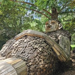
    Bernheim Forest and Arboretum - Mama Loumari giant

    Mama Loumari giant

    Bernheim Forest and Arboretum

    See all

    Tioga Falls Trail - Bottom of falls

    Tioga Falls Trail

    4.5(26 reviews)
    26.6 km

    This little hike was recommended to me after a snowstorm--which I definitely would not suggest…read more It's mostly uphill, and the wind turned everything into ice, making it really challenging to traverse. Outside of that particular experience (and once I was on the return down-hill), I realized this trail is short, simple, charming , and easy, with a few spots offering really pretty overlook views along the way. About halfway in, a babbling creek starts to follow you, hinting that you're nearing the final destination. Then you can hear the waterfalls before rounding a bend to reveal them. The falls are fantastic with multiple levels and a very peaceful melody. Just a heads-up: the trail begins with a walk down a service road since the original trail is now on private property, roped off as part of a very interesting-looking old house/building. At the end of the service road, there's a short but steep uphill path path to rejoin the trail. After that--smooth sailing.

    Such a beautiful trail. It was easy to get around but luckily I was with someone that knew exactly…read morewhere she was going. The first big bill up the trail was a doozy. I wasn't ready for that, but I made it! We got some beautiful pictures of the waterfall. The waterfall was easy to walk around in and can get wet if you wanted too. Great place to cool down as well. There was also a train track that we walked on and it was right over a creek. Very high up but cool to see. I would definitely go back to visit the trail. I will know more of what I'm getting into next time.

    Photos
    Tioga Falls Trail
    Tioga Falls Trail
    Tioga Falls Trail - Multi-level waterfalls!

    See all

    Multi-level waterfalls!

    Broke Leg Falls

    Broke Leg Falls

    3.5(2 reviews)
    188.4 km

    Came here with the intention of seeing a beautiful waterfall, and the place was dried up! It is…read morebeautiful in photos I had seen, but not on this trip. Since this is located near our cabin, I'm sure we will be back at another time when the falls are full. Just not this time around. What is there to say? Well, they have a ton of walkways that were added, making it accessible for all types of people. This isn't ADA accessible, but it is an easy up and down for those who can't move strenuously. There are places to sit where you can go underneath the waterfall when applicable, and it offers a really pretty view from almost all vantage points. There just isn't any water right now as the time of writing this. Maybe next time...

    We are traveling with no time schedule, just on the lookout for unique things! A google search led…read moreus to the falls. Upon arriving, we found a nice parking area, along with a port-a-potty. There were several little picnic areas and seating areas within feet of the parking lot. This is definitely one of the most accessible scenic areas we've been to. There are stairs with handrails heading down into the gorge. You can walk across the falls on a wooden bridge and then head down more stairs to the bottom. At this point, you can either turn around and head up, or if you're more adventurous and want to head off on a less groomed path and over some rocks, you can do that! Unfortunately, the waterfall was not flowing when we were there. I had assumed it always was, so was a little disappointed at that. I have since read up on it a bit and it seems rainy season is the best time to go to see the falls in all their glory! However, since it was dry, we could climb over rocks and explore rather safely. We hiked for a while and then turned back, as we weren't sure how far it went and we needed to hit the road. We spent about 30-45 minutes walking around and taking it in. You can make this stop in as a little as 5-10 minutes if you wanted. Longer to explore! It was beautiful! If you're in the area and have time to stop, I recommend it!

    Photos
    Broke Leg Falls
    Broke Leg Falls
    Broke Leg Falls

    See all

    Cherokee Park

    Cherokee Park

    4.8(166 reviews)
    33.6 kmHighlands- Cherokee Triangle

    Cherokee is a gem in East Louisville. It has a winding road that is bike and pedestrian friendly…read more They've carved out half the road for cars and the other half for walkers, runners, and bikers. The full loop is 2-4 miles with lots of trail cut throughs in the woods that are both bike and walker or runner friendly. There are two big hills, each with restrooms, playgrounds, and water fountains. There are gazebos for picnics. The Hogans fountain area has a better playground and a splash pad, basketball court, and a wide open, flat field. Dog Hill is rolling on top of the hill. The hill itself is great for sledding in the winter. On the last Sunday of each month, the park is fully closed to cars, which is great for kids, adults, and pets. The crew that maintains the park does an excellent job keeping it clean, the trails clear, and combating invasive plants. You'll see lots of wildlife - deer, fox, hawks, turtles, etc.

    We did a walk in a portion of Cherokee Park on a very windy Sunday morning. We noted that cars…read morestill travel too fast for comfort when near pedestrians. Plenty of walkers, runners, bikers, dog walkers, recreational users (frisbees and kites), tailgaters, and drivers today. We stopped to catch a break near the top of the hill at Hogan's Fountain. The water fountains and faucets (to fill up dog bowls) were all operational today in mid-March. Restroom facilities were also open.

    Photos
    Cherokee Park
    Cherokee Park
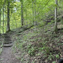
    Cherokee Park - Steps.

    See all

    Steps.

    Fairmount Falls

    Fairmount Falls

    4.8(4 reviews)
    18.8 km

    Fairmount falls is a hidden and very well kept Louisville treasure. This is a walking trail located…read morein the fern creek/zoneton areas of Louisville. For whatever reason it is owned by Jefferson memorial Forrest which is in Fairdale a good 20 min away. The park area is blocked off by rope and a lock. To get the lock combo you have to call 502-368-5404 and hit "0" for the operator. At that time either someone will pick up and you tell them you want to reserve a spot for Fairmount falls and the date you need it. Or you can leave a voicemail and they will call you back ASAP. If available (only 3 cars a day) they will get your vehicle make and color and license plate number and give you the code. They will tell you to enter the home address of 9601 thixton lane but the entrance is actually across the street. How hidden and unknown is this place? I live literally a mile from here for the last 3 years. I had no idea it even existed. I've probably drove by the hidden entrance 20 good times with no idea. The woods and creek that it attaches is literally the same woods and creek in my actual back yard. If I was grizzly adams I could probably find a way to navigate or kayak my way there. But I'm not about that life. It's the 21st century and I have no problem calling a phone number, reserving a day and driving myself here. As alluded to the entrance is very small and tight (large vehicles may have to adjust a few times) and hard to miss. When you take the rope off you have a tiny parking area and a nice picnic table area. From there you start the trail. The trail is 1.1 miles round trip and it is a loop. First part of the trail has a variety of beautiful mossy rocks and fallen trees in a well beaten out and carved out nature trail. You will come up to a normal road and have to cross it to continue the trail. At that point is where you approach the breathtaking and beautiful Fairmount falls. They have a few side trails to get closer looks and photos. However you will be cross over the falls shortly while staying on the trail. When on top of the falls your feet will get a little wet. There is no barricades so you have to be careful of you dare get closer to the edge for a look see. It's pretty much straight rock in what I'd say is well over a 50 foot drop. So there is not walking it off if you slip. So proceed off trail with extreme caution. The trail continues through more beautiful natural Forrest areas. Including some nice random spots that had yellow water Lilly's that popped up. That second half also has a couple bench areas to sit and relax in the woods. The second half of this trail once you cross the waterfall has some very muddy spots. It is flat Ground and you can trek around them in the woods. Which you can tell has been done before as a second path is starting to emerge. Eventually you loop back around to the waterfall and head back to the beginning. Fairmount falls is Breathtaking, peaceful and quiet. You feel like your in on a top secret place when going there because you will likely be the only ones there and upon arrival you have to take a lock off the rope then lock it behind you and do the same when leaving. Being a mile away from my house I'll reserve this a bunch moving forward. It's an easy well shaded walking trail and relaxing. My family and I have done majority of Louisville walking trails. There isn't another waterfall like this nearby. So it is unique too. Overall extremely glad to have found this hidden gem. I would highly recommend for any nature lover!

    We went hiking here last week my daughter and I with my buddy and his kids. And my friend called…read moreGod is the code to get into the Fairmont Falls cause only allow three vehicles at a time I believe that not here by far is that rules though because we saw Alyssa good for five when we were there but we were legit we had correct place in line and we put our names in I don't know if they did or not and I don't know I guess you can just use the same code every time I'm not sure. But besides the point we got there had a lot of cool photo ops had a lot of cool little waterfall things going on and just saw lotta good things good big hiking loop going across the whole thing is like a mile long and easily marked And easily accessible for all of us and we had a really good time I will definitely be back to this place and I bet he's already giving back the same day with the rest of his family so he really enjoyed it so I will definitely be back it's a fun little hiking trail if you like woods and you like hiking you'll like this place

    Photos
    Fairmount Falls
    Fairmount Falls
    Fairmount Falls - Daughter had her friends here for her 14th birthday party

    See all

    Daughter had her friends here for her 14th birthday party

    Pine Creek Barrens

    Pine Creek Barrens

    4.5(2 reviews)
    5.9 km

    Pine creek barrens is a nature conservatory or nature trail buried kind of deep into Shepherdsville…read moreKentucky about 3-4 miles off the cedar grove road exit in Shepherdsville. ***Major disclaimer I want everyone to know. Bring Tick repellent. We were with a group of 11 and no exaggeration we pulled well over a 100 ticks off us during and after the trail. We still are honestly. And I'm not sure why. The place is well kept and well paved. So you aren't trekking through high weeds or grass. Moving on, you pull into a smallish gravel parking lot and you can either go left or right. This is a 3 mile loop trail that takes you in a circle. Ten signs say it takes 2 hours approximately. However we walked slow and stopped store several pictures and tick check breaks and got it down in just under 90 minutes . It is full of pretty views of nature, flat lands, forest views, creek water, waterfalls and some really cool Rock formations. We enjoyed this walk. It really was very easy. Mainly flat and what Hills you come across were easy to climb. As mentioned it is Well paved and also well marked. I feel like there was a painted or marked tree every ten feet it seems. They also have a few benches for resting if needed. Ten whole path was pretty shaded and mainly dry. We came across a few different critters along our 3 mile walk. We seen a few snakes, interesting birds, bugs, a frog and a salamander. Evidently none of which eats ticks because if they did they would of been in food paradise Overall enjoyable and fun walk with pretty scenery. Kinda tough to find. I'd recommend following the winery signs and keeping your eyes peeled for the parking lot on the left. It been nicer if we aren't at risk of Lyme disease or rocky mountain spotted fever as there was a million ticks here that were waiting to feast it seems. It was an insane amount of ticks. I've never seen so many in my life. I wouldn't be opposed to coming back but it will not be in the spring. Maybe this will be a winter or cold weather trail for us.

    This is a fantastic place that my daughters and I visited on a Saturday morning in the fall. The…read moretrees are beautiful little community is very nice the Pats are fantastic I have no complaints about this place whatsoever Besides the parking. The thing with the parking is it's very small so it was hard to get a spot so I wish they would expand that part it is back in pine forest community. But it's very beautiful and I highly recommend that you check it out five out of five stars

    Photos
    Pine Creek Barrens
    Pine Creek Barrens
    Pine Creek Barrens

    See all

    Rock Run Loop - hiking - Updated August 2026

    Loading...
    Loading...
    Loading...