Salmon River State Forest Photos


You might also consider
More like Salmon River State Forest
Recommended Reviews - Salmon River State Forest
Start your review...

Reviews With Photos

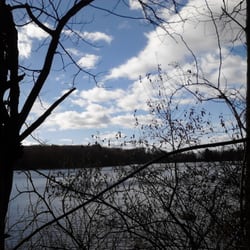
We found this place through Yelp and are so glad we did. My teen daughter and I brought our dog and hiked most of the north loop. It had inclines and some areas with lots of roots, so I'd rate it as moderate. On the way back down, we stopped and went down to the bank of the river to dip our feet in the cool water. There were a couple of neighborhood dogs running up and down the trail and taking little forays into the water, but they were friendly, so we didn't mind. The trail and the river were all clean and well taken care of. There is an amazing covered bridge that visitors cross over from the parking lot to get to the trailhead. We saw individual and small groups of hikers, including some younger kids, so this is definitely family-friendly. We will definitely be back to try one of the other trails.

8 years ago
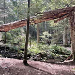
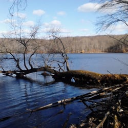
We've made a couple of visits to the Salmon River State Forest since we moved to CT. There are a couple of parks and trails that go through the forest - The Air Line Trail and Day Pond State Park are both inside the forest, and the Salmon River Trail goes through it, around Day Pond park and over to the Comstock Covered Bridge. The trails are well maintained and well signed, and this is overall a great place to spend time hiking or fishing. read more


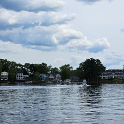
Throw on the waders & walk with me, we're going down memory river. 20 years ago, I got my first taste of what would become a family & friends sacred holiday. The Opening Day of Fishing Season. Thats right. I said its sacred. Fishing season is one of few things I can discuss for more than 2 minutes with my father without getting into a heated argument. Luckily, we start talking about fishing season at least 8 months in advance. Our little rivalry dwarves yankees / red sox, duke/UNC, mc hammer / bankruptcy lawyers, and boxers / briefs. How important is fishing season? When I was in NorCal and was questioning being able to make it to Opening Day, I was touched when bff Hetch-Boogie offered to pay for the flight (What I really did was turn tricks on the streets of Oakland). We take time off from work months in advance. Hell, we have family whose ashes are spread throughout this river. Another friend made a girlfriend an ex for suggesting he stay home with her on Opening Day. We take it that seriously. Hell, my family postponed funeral arrangements to accommodate Fishing Season. Ive missed Thanksgiving with family. HetchBoogie has missed Christmas Eve & Christmas Day. Jesse has missed Easter & all sorts of holidays. But I'll be damned if we've missed Opening Day the last 20 years. So naturally when I need to unwind, the Salmon is where its at. Twitchy Pat B loves to walk a stream to ease his troubled mind and the rocks & rapids throughout Salmon River State Park allow me to do just that. Unless of course, my father is throwing rocks into the spot where Im fishing. Again. Jackass. read more


9 years ago
We found this place through Yelp and are so glad we did. My teen daughter and I brought our dog and hiked most of the north loop. It had inclines and some areas with lots of roots, so I'd rate it as moderate. On the way back down, we stopped and went down to the bank of the river to dip our feet in the cool water. There were a couple of neighborhood dogs running up and down the trail and taking little forays into the water, but they were friendly, so we didn't mind. The trail and the river were all clean and well taken care of. There is an amazing covered bridge that visitors cross over from the parking lot to get to the trailhead. We saw individual and small groups of hikers, including some younger kids, so this is definitely family-friendly. We will definitely be back to try one of the other trails. read more


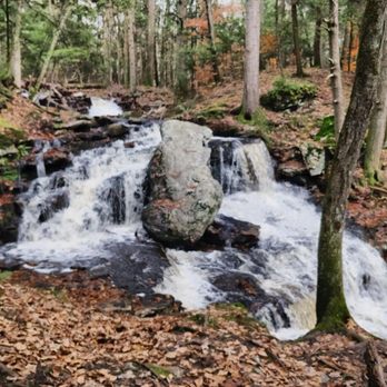
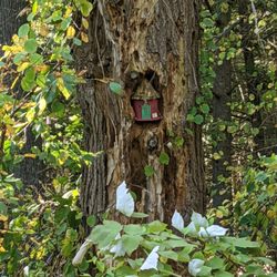
Absolutely beautiful area! If you like hiking, trail running or nature walks, the trails take you through some lovely areas. If you just feel like hanging out, the river itself has some great spots for lying out or cooling off. They say a picture is worth a 1000 words, so stop reading and check out my pics 8-) read more


 - Parks Near Me - Colchester, Connecticut")


More info about Salmon River State Forest
You might also consider


Salmon River State Forest - parks - Updated July 2026
Best of Colchester
People found Salmon River State Forest by searching for…
Things to Do in Colchester, CT
Hiking Trails With Waterfalls in Colchester, CT
Fishing Spots in Colchester, CT
Places to Take Pictures in Colchester, CT
Waterfalls and Swimming Holes in Colchester, CT
Walking Trails in Colchester, CT
Running Trails in Colchester, CT
Crabbing Location in Colchester, CT
Dog Friendly Hiking Trails in Colchester, CT
Dog Swimming in Colchester, CT
River Swimming in Colchester, CT
Parks for Kids in Colchester, CT
Scenic Overlook in Colchester, CT
Picnic Spots in Colchester, CT
Places to Run in Colchester, CT
Forest Preserves in Colchester, CT
Outdoor Basketball Courts in Colchester, CT
Hiking Groups in Colchester, CT
Trending Searches in Colchester, CT
Beautiful Views near Salmon River State Forest
Black Owned Nail Salons near Salmon River State Forest
Blueberry Picking near Salmon River State Forest
Boardwalk near Salmon River State Forest
Boat Launch near Salmon River State Forest
Cliff Jumping near Salmon River State Forest
Day Trips near Salmon River State Forest
Dog Friendly Beaches near Salmon River State Forest
Dog Friendly Trails near Salmon River State Forest
Fishing Charter near Salmon River State Forest
Fishing With Kids near Salmon River State Forest
Jet Ski Rental near Salmon River State Forest
Kayak Rental near Salmon River State Forest
Kids Activities Outdoor near Salmon River State Forest
Lakes near Salmon River State Forest
Lakes & Ponds near Salmon River State Forest
Off Road Trails near Salmon River State Forest
Outdoor Activities near Salmon River State Forest
Outdoor Basketball Courts near Salmon River State Forest
Parks For Parties near Salmon River State Forest
Parks For Picnics near Salmon River State Forest
Peach Picking near Salmon River State Forest
Picnic Spots near Salmon River State Forest
Places To Swim near Salmon River State Forest
Pontoon Boat Rentals near Salmon River State Forest
Pool Day Pass near Salmon River State Forest
Private Boat Charters near Salmon River State Forest
Public Beaches near Salmon River State Forest
Public Shower near Salmon River State Forest
River Swimming near Salmon River State Forest
Rock Quarry near Salmon River State Forest
Scenic Drive near Salmon River State Forest
Scenic Night View near Salmon River State Forest
Scenic Overlook near Salmon River State Forest
Secluded Spots near Salmon River State Forest
Skyline View near Salmon River State Forest
Soccer Store near Salmon River State Forest
Sunrise View near Salmon River State Forest
Sunset Cruise near Salmon River State Forest
Swimming Holes near Salmon River State Forest
Swimming Lakes near Salmon River State Forest
U Pick Farms near Salmon River State Forest
Watch Sunset near Salmon River State Forest
Water Parks For Kids near Salmon River State Forest
Waterfalls And Swimming Holes near Salmon River State Forest
Browse Nearby
Browse Brands
Related Searches in Colchester, CT
Affordable Canoe Rental Options in Colchester, Connecticut
Affordable Kayak Rental Services in Colchester, Connecticut
Best Boat Launch Spots in Colchester, Connecticut
Best Crabbing Locations to Visit in Colchester, Connecticut
Best Dog Hiking Trails Around Colchester, Connecticut
Best Fishing Locations and Guides in Colchester, Connecticut
Best Off Leash Dog Parks in Colchester, Connecticut
Best Parks for Parties and Events in Colchester, Connecticut
Best Places for Horseback Riding in Colchester, Connecticut
Best Sightseeing Experiences Available in Colchester, Connecticut
Best Water Parks for Kids in Colchester, Connecticut
Best Waterfalls and Swimming Holes in Colchester, Connecticut
Book Private Boat Charters for Trips in Colchester, Connecticut
Book Top Fishing Trips in Colchester, Connecticut Today
Book a Dinner Cruise Experience in Colchester, Connecticut
Check Out Great Playgrounds in Colchester, Connecticut
Discover Baseball Fields Around Colchester, Connecticut
Discover Dog Friendly Trails to Explore in Colchester, Connecticut
Discover Fun Toddler Parks in Colchester, Connecticut for Your Little One
Discover Lakes & Ponds to Explore in Colchester, Connecticut
Discover Popular Bike Trails in Colchester, Connecticut
Discover Public Beaches to Visit in Colchester, Connecticut
Discover Soccer Fields in Colchester, Connecticut Near You
Discover Top Boat Tours in Colchester, Connecticut for All Ages
Discover Top Nature Parks to Visit in Colchester, Connecticut
Discover Top State Parks to Visit in Colchester, Connecticut
Discover the Best Beaches in Colchester, Connecticut
Discover the Best Fishing Lake in Colchester, Connecticut
Discover the Best Night Hike Trails in Colchester, Connecticut
Discover the Best Sunset Cruise Tours in Colchester, Connecticut
Dog-Friendly Hikes With Dogs in Colchester, Connecticut
Enjoy Camping Adventures Around Colchester, Connecticut
Enjoy Fishing With Kids in Colchester, Connecticut Safely
Enjoy Hiking Adventures in Colchester, Connecticut
Enjoy Kayaking Adventures in Colchester, Connecticut
Enjoy Off Leash Dog Hikes in Colchester, Connecticut
Enjoy Sailing Adventures in Colchester, Connecticut
Enjoy Scenic Places to Walk in Colchester, Connecticut
Enjoy Tent Camping Spots Around Colchester, Connecticut
Enjoy Whale Watching Experiences in Colchester, Connecticut
Enjoy a Beautiful Waterfall Hike in Colchester, Connecticut
Enjoy a Scenic Boat Ride in Colchester, Connecticut
Enjoy the Best Picnic Spots and Ideas in Colchester, Connecticut
Enjoy the Best Walking Trails in Colchester, Connecticut
Experience Deep Sea Fishing Adventures in Colchester, Connecticut
Experience Scenic Boat Cruises in Colchester, Connecticut
Experienced Fishing Guides Available in Colchester, Connecticut
Explore Beautiful Parks and Green Spaces in Colchester, Connecticut
Explore Easy Hikes Perfect for All in Colchester, Connecticut
Explore Family-Friendly Zoos and Wildlife in Colchester, Connecticut
Browse Articles
People who viewed Salmon River State Forest also viewed
Devil's Hopyard State Park
53 reviews
Chatfield Hollow State Park
28 reviews
Mansfield Hollow State Park
5 reviews
Hurd State Park
6 reviews
Ragged Mountain
22 reviews
Talcott Mountain State Park
50 reviews
Walnut Hill Park
19 reviews
Quinnipiac Linear Trail
16 reviews
Millers Pond State Park
5 reviews
New England Trail Asylum Reservoir
2 reviews