Wildcat Peak Photos



You might also consider


More like Wildcat Peak
Recommended Reviews - Wildcat Peak
Start your review...


Reviews With Photos


Just did the hike up from the environmental center this past Sunday (Wildcat Peak Trail then back down using Laurel Canyon Trail). Boy it was muddy but it added to our adventure, seriously though you could not see your shoe at certain points and it was a gradual uphill the whole way. I would suggest waiting a few days after the rain to take this path. The nice thing though about the rain is that you could see all the animal foot prints. We came across some raccoon and deer tracks and some unknown very large hoofed animal. Be sure you check out the groove when you get close to the top, probably the only place you will see George Bush and Mother Teresa's name next to one another. You will know that you are in the grove when you see some very large Christmas Trees. On the hike down be sure to check out all the animals at Little Farm - sheep, cows, chicken's, geese, bunny's and huge pigs!


Great variety of trails. Love the hills and seeing cows, wild turkey, deer, owls, hawks and coyotes. Small hikes from 1-2 miles to getting into Tilden & Conlon trail, you can easily make a 14-16 mile hike. Great in late fall, winter and spring. My go to hiking place.


I made the hike up to the peak on a Monday afternoon in search for an excuse to brush some dust off of my camera. The first half of the hike up was more scenic and lush forest that turned a little more dry and plains like in the middle (this is where a lot of lizards start appearing). If you're like me and have a terrifying fear of reptiles, you might want to bring a friend or refrain from the latter part of the hike. But if you do decide to continue on as I did, the view from the top is absolutely breathtaking and totally worth it. And for those who care about cell phone reception, there isn't any from the parking lot until about 3/4ths of the way up towards the peak.


One of those backyard discoveries that makes me question why it's taken me so long to actually get here. Welp... I finally made it here. And it is truly sensational. I've pretty much been all up, down, and around Tilden Park. But even with that, I always seem to discover trails that I've never hiked before. It's a huge park, so that makes total sense. Wildcat Peak was one of those recent discovery trails and vista points for me. I've always seen it on the park map, but you know when you get used to hiking on your favorite trails and you neglect all of the rest? That was me. I mean, that IS me. A creature of habit I guess. So on this very day, I decided to explore a different part of Tilden. Entered the park through the nature area and started near Jewel Lake on the Wildcat Creek Trail. This trail is super easy, flat, and partially paved. You'll pass by Jewel Lake along this trail. Turned right onto Sylvan and then left onto the Wildcat Peak Trail. This part of the Wildcat Peak Trail features switchbacks that incline up to the peak. It's a nice workout in general, but the views of the Bay is what makes this jaunt super enjoyable. Once you reach the peak, you'll have the most incredible views of the Bay Bridge, Briones Reservoir, San Pablo Bay, and Berkeley city views. There's a little brick barrier wall at the summit where you can sit and admire the views. It's 360 degrees of pure scenic bliss up there. From here, you can go back the same way you came up, or you can connect to another trail. I connected to the Laurel Canyon trail which looped me back around to the Tilden Nature area. There are so many vibrant wildflowers and plants nestled along this trail loop. The trail has a nice mix of covered and exposed paths. You'll pass through beautiful groves and notice the rampant wildlife on the trails. In the late winter and early spring, it's so incredibly green here. Wildcat Peak is such a gorgeous vista point within Tilden Park. I'd highly recommend the Wildcat Creek/Wildcat Peak/ Sylvan/Laurel Canyon trail loops. It's simply marvelous. read more


It's hard to imagine that the bucolic fire roads in Wildcat Canyon and Tilden Park once connected the US military with missile radar stations and launch sites during the depths of the Cold War. Or maybe not given the escalating tensions we have with Russia. But back in 1962 during a moment of atypical calm, a stone circle was built by the Berkeley Rotary Club to allow people agitated by the Commies a meditative spot to take in panoramic, 360-degree views of the SF Bay Area to the west and San Pablo Reservoir to the east. Years later it's still a nice respite if it isn't crowded up here as it sometimes does on warm weekends. Most people walk on Nimitz Way, the mostly paved path from Inspiration Point, to get here. However, my favorite route starts on the Wildcat Creek Trail where I take the gradual climb on the Conlon Trail where you get the same bay views you get from the peak. Except maybe for a herd of unimpressed cows in your way. I then descend on the zig-zaggy Wildcat Peak Trail back to Wildcat Creek. Gee, I sound like an actual hiker, don't I? RELATED - Up for a hike? Here's a collection of trails I've walked and reviewed: https://bit.ly/2OrC8nU read more


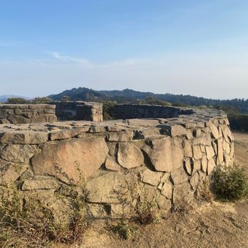


This is my go-to place when I want a quick cardio workout in nature after work. From the parking lot to Wildcat Peak RT is 3.75 miles (a mile of it is on the flat Wildcat Creek Trail, the rest goes uphill on trails- follow the Peak Trail symbol which looks like a mountain). There is one water fountain along the Wildcat Creek Trail. NOTE: The parking lot closest to Wildcat Creek Trail shuts at 8:00 p.m. so plan your hike accordingly. It's a consistent uphill climb to the top (elevation: 1,250 feet). There is a circular stone observation plaza at the top (finished in 1962), a great place to catch your breath and enjoy the beautiful surroundings. If the weather cooperates, you'll have a spectacular view in any direction: the San Francisco Bay, Mt. Tamalpais, Angel Island, San Pable Reservoir, Mt Diablo, and the three bridges: Golden Gate, Richmond Bridge and Bay Bridge. Enjoy! :) read more


Just did the hike up from the environmental center this past Sunday (Wildcat Peak Trail then back down using Laurel Canyon Trail). Boy it was muddy but it added to our adventure, seriously though you could not see your shoe at certain points and it was a gradual uphill the whole way. I would suggest waiting a few days after the rain to take this path. The nice thing though about the rain is that you could see all the animal foot prints. We came across some raccoon and deer tracks and some unknown very large hoofed animal. Be sure you check out the groove when you get close to the top, probably the only place you will see George Bush and Mother Teresa's name next to one another. You will know that you are in the grove when you see some very large Christmas Trees. On the hike down be sure to check out all the animals at Little Farm - sheep, cows, chicken's, geese, bunny's and huge pigs! read more


11 years ago

10 years ago
Great variety of trails. Love the hills and seeing cows, wild turkey, deer, owls, hawks and coyotes. Small hikes from 1-2 miles to getting into Tilden & Conlon trail, you can easily make a 14-16 mile hike. Great in late fall, winter and spring. My go to hiking place. read more




12 years ago
I made the hike up to the peak on a Monday afternoon in search for an excuse to brush some dust off of my camera. The first half of the hike up was more scenic and lush forest that turned a little more dry and plains like in the middle (this is where a lot of lizards start appearing). If you're like me and have a terrifying fear of reptiles, you might want to bring a friend or refrain from the latter part of the hike. But if you do decide to continue on as I did, the view from the top is absolutely breathtaking and totally worth it. And for those who care about cell phone reception, there isn't any from the parking lot until about 3/4ths of the way up towards the peak. read more


10 years ago
Best 360 degree view in Tilden! Volmer peak is taller, but it has a radio building blocking a true 360 view. read more


14 years ago

11 years ago
More info about Wildcat Peak
Nimitz Way
Berkeley, CA 94708
Directions
Hours
Outdoor Amenities
Ask the Community - Wildcat Peak
Review Highlights - Wildcat Peak
You might also consider






















Wildcat Peak - hiking - Updated August 2026
Best of Berkeley
People found Wildcat Peak by searching for…
Trending Searches in Berkeley, CA
Cliff Jumping near Wildcat Peak
Consignment Shops near Wildcat Peak
Cruising Spots near Wildcat Peak
Dog Friendly Beaches near Wildcat Peak
Dog Friendly Things To Do near Wildcat Peak
Ear Piercing near Wildcat Peak
Eyebrow Threading near Wildcat Peak
Fishing Spots near Wildcat Peak
Flower Fields near Wildcat Peak
Hair Braiding near Wildcat Peak
Kids Haircut near Wildcat Peak
Permanent Makeup near Wildcat Peak
Picnic Areas near Wildcat Peak
Public Golf Courses near Wildcat Peak
Public Running Track near Wildcat Peak
Running Trails near Wildcat Peak
Scenic Night View near Wildcat Peak
Scenic Overlook near Wildcat Peak
Sunrise View near Wildcat Peak
Swimming Holes near Wildcat Peak
Things To Do With Kids near Wildcat Peak
Trading Card Shops near Wildcat Peak
Used Furniture Stores near Wildcat Peak
Volleyball Courts near Wildcat Peak
Browse Nearby
BEST of Berkeley, California Coffee near Wildcat Peak
BEST of Berkeley, California Restaurants near Wildcat Peak
BEST of Berkeley, California Things to Do near Wildcat Peak
BEST of Berkeley, California Walking Trails near Wildcat Peak
BEST of Berkeley, California Parks near Wildcat Peak
BEST of Berkeley, California Breakfast near Wildcat Peak
BEST of Berkeley, California Campgrounds near Wildcat Peak
Browse Brands
Related Searches in Berkeley, CA
Best Dog Hiking Trails Around Berkeley, California
Best Fishing Locations and Guides in Berkeley, California
Best Nature Trails for Hiking in Berkeley, California
Best Off Leash Dog Parks in Berkeley, California
Best Parks for Parties and Events in Berkeley, California
Best Places for Horseback Riding in Berkeley, California
Best Sightseeing Experiences Available in Berkeley, California
Best Water Parks for Kids in Berkeley, California
Check Out Great Playgrounds in Berkeley, California
Check Out Off Road Trails in Berkeley, California
Discover Baseball Fields Around Berkeley, California
Discover Dog Friendly Trails to Explore in Berkeley, California
Discover Easy Hiking Trails Near Berkeley, California
Discover Fun Toddler Parks in Berkeley, California for Your Little One
Discover Kid Friendly Hiking Trails in Berkeley, California
Discover Lakes & Ponds to Explore in Berkeley, California
Discover Popular Bike Trails in Berkeley, California
Discover Popular Photo Spots in Berkeley, California
Discover Scenic Mountain Bike Trails Near Berkeley, California
Discover Soccer Fields in Berkeley, California Near You
Discover Top Nature Parks to Visit in Berkeley, California
Discover Top State Parks to Visit in Berkeley, California
Discover Walking Parks in Berkeley, California Near You
Discover a Hiking Trail in Berkeley, California
Discover the Best Beaches in Berkeley, California
Discover the Best Kids Park Spots in Berkeley, California
Discover the Best Night Hike Trails in Berkeley, California
Dog-Friendly Hikes With Dogs in Berkeley, California
Enjoy Camping Adventures Around Berkeley, California
Enjoy Kayaking Adventures in Berkeley, California
Enjoy Off Leash Dog Hikes in Berkeley, California
Enjoy Scenic Places to Walk in Berkeley, California
Enjoy a Beautiful Waterfall Hike in Berkeley, California
Enjoy the Best Picnic Spots and Ideas in Berkeley, California
Enjoy the Best Walking Path in Berkeley, California
Enjoy the Best Walking Trails in Berkeley, California
Explore Beautiful Parks and Green Spaces in Berkeley, California
Explore Easy Hikes Perfect for All in Berkeley, California
Explore Free Picnic Areas Around Berkeley, California
Explore Fun Activities to Do in Berkeley, California
Explore Parks With Pull Up Bars in Berkeley, California
Explore Picnic Parks Near Berkeley, California
Explore Popular Campgrounds Near Berkeley, California
Explore Popular Dog Walking Trails in Berkeley, California
Explore Popular Kids Parks Throughout Berkeley, California
Explore Popular Picnic Areas Around Berkeley, California
Explore Popular RV Parks Around Berkeley, California
Explore Scenic Lakes to Visit in Berkeley, California


