Woodstock Tower Photos


More like Woodstock Tower
Recommended Reviews - Woodstock Tower
Start your review...

Reviews With Photos
")
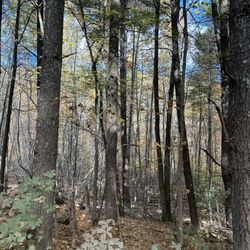
This is a nice place to stretch your legs and enjoy nature. Pros: simple trail, not a ton of stairs, the great outdoors(always exciting!), wonderful workout if you're wanting to run up the hill to get to the tower(highly recommended by locals just be on the cautious side as it is a steep, very curvy thoroughfare) and vast views. Cons:can be harder to see things due to weather but it's still alluring, the trip up the hill via car is incredibly steep with harsh angles to negotiate and lane is not wide enough for two cars in most areas. Also the stairs up the tower are very see through so just focus on the views you will see vs the ones below you. It proves very true to what is advertised, "Land of Many Use." How you use it is up to you.

Amazing views in George Washington National Forest. Well worth the drive if you're in the Woodstock VA area (it's about 10 minutes from downtown). The drive is scenic and the park is great for hiking - just watch out for the black bears if you're 3-4+ miles out on the trails. This really is a gem and a must-see in the area.

I lived in the surrounding area for a short amount of time back in the day. We used to come here and "watch the grass grow" fairly often. lol... It's just a beautiful place, and to jump in the Shenandoah River on a hot day made this spot even more fun to visit. This weekend, about 20 some years later, I took my kids and their friends here. It was just as I remembered and they too fell in love with the tower, hike, river and the whole 9 yards. It's great to pass down history and locations like this to the newer generations. Get outdoors and see your surroundings. What happened here and how important it is to preserve and protect these places. They loved the road to and from here just as I used too...it was great to re-live this time from my past with them. So happy this still stands!

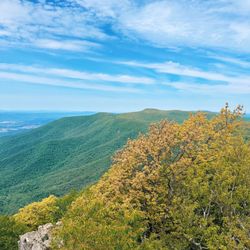
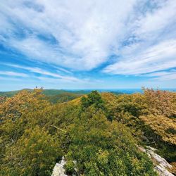
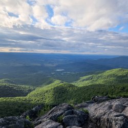
Love this local spot! First things first - SAFETY. Be very careful as you traverse Woodstock Tower Road, it's fairly narrow and has a lot of blind switchbacks, so take it slow. Also, it's a decently steep grade so keep your gearing low, ESPECIALLY on the way down. There is a small lot that fits about 4 cars on the summit, from there it's a short hike (10-15 mins) on Woodstock Tower Trail to the tower. The tower rises to just above the treeline giving you an absolutely INCREDIBLE view of the surrounding area. To the west you can easily see the town of Woodstock and the "7 Bends" of the Shenandoah River. To the east is a beautiful scene... mountains, valleys and forest as far as you can see. I hope to come back at night some time because there is hardly any light pollution in this area, the stars must look unbelievably gorgeous. A few little notes for you folks: - The stairs are narrow and steep - They are made of those steel grates so you can see through them - The platform can also be easily seen through - It DOES sway in the wind a bit If any of that bothers you... try to go up anyway, it's totally worth it.


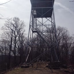

Great place with great views! Pop "Woodstock Tower" into Google Maps, and it will take you to the right spot (Apple Maps only took me to the trailhead a distance away). This will put you near a little overlook off the dirt road or if you keep going, a small gravel parking lot. Be prepared to drive on dirt and gravel roads for over a mile to get here; you are going the right way! This end of the trail has a clearly marked sign saying it is the Woodstock Tower. From either of those parking lots it's only about ¼ mile walk to get to the tower. The path varies from rocky to flat dirt. Loads of hickory nuts line the path. You could also come from the other end of the trail, which is over a mile away in the other direction. The climb up is steep but manageable (I'd recommend being more careful descending!) with metal steps. Considering she's still standing 90 years after her construction, I'd say the tower is stable. Hats off to the Civilian Conservation Corps for building this lasting landmark! The views from the top are great and worth the short walk and short climb. I met a local man at the top who shoots a lot of videos from up there. He did warn that sometimes there are black bears in the area; I never saw one my whole time, but just keep alert. It was a little cold on the mid-October day we were there and the top of the mountain did mean lots of cross wind, so dress appropriately. Unless you're weird about heights (apologies to my wife; thanks for walking out to it with us, Baby), this is a worthwhile visit. Definitely recommend! read more


7 years ago
What a pleasant surprise! We drove up the mountain on Christmas Eve and simply enjoyed the views. Our goal of finding the tower wasn't easy being that my bf hadn't been up there since he was a kid. Nevertheless we found it :-) I was a bit apprehensive of climbing it at first but took baby steps lol. What a beautiful scenery once you reach the top. Great experience! read more


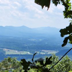
This place is a hidden gem just east of Woodstock in the George Washington National Forest. There are two approaches to the tower: 1. From the SE via Woodstock or 2. From the north via Strasburg or Front Royal. The approach from Woodstock is NOT for the faint of heart or timid. The drop offs are severe and unforgiving and the switchbacks are intense. The approach from the north is straightforward, but you will have ZERO cell service for the majority of the drive in. It's clear that the folks living along the gravel road are there to be away from civilization and the ample signage warding off trespassers enforces that. Make sure you know the turns and have plenty of gas before heading that way. Once you arrive at the parking area, the entrance to the tower path is indicated by a sign embedded in stone. It's a short walk through the woods along the pink blaze to reach the base of the tower. Three sets of stairs gets to you the top and gorgeous views to the east and the west of the ridge line. There's been no shortage of vandalism of the tower and trash was not in short supply along the trail and at the base of the tower. The structure of the tower itself seems sound, but the wire fence material at the top and under the railing seems woefully inadequate at preventing a fall. Definitely worth the trip if you are in the area, but choose your entrance path wisely and mind your step at the top. read more


8 years ago
This is a nice place to stretch your legs and enjoy nature. Pros: simple trail, not a ton of stairs, the great outdoors(always exciting!), wonderful workout if you're wanting to run up the hill to get to the tower(highly recommended by locals just be on the cautious side as it is a steep, very curvy thoroughfare) and vast views. Cons:can be harder to see things due to weather but it's still alluring, the trip up the hill via car is incredibly steep with harsh angles to negotiate and lane is not wide enough for two cars in most areas. Also the stairs up the tower are very see through so just focus on the views you will see vs the ones below you. It proves very true to what is advertised, "Land of Many Use." How you use it is up to you. read more
 - Local Flavor Near Me - Fort Valley, Virginia")


Amazing views in George Washington National Forest. Well worth the drive if you're in the Woodstock VA area (it's about 10 minutes from downtown). The drive is scenic and the park is great for hiking - just watch out for the black bears if you're 3-4+ miles out on the trails. This really is a gem and a must-see in the area. read more

9 years ago
I lived in the surrounding area for a short amount of time back in the day. We used to come here and "watch the grass grow" fairly often. lol... It's just a beautiful place, and to jump in the Shenandoah River on a hot day made this spot even more fun to visit. This weekend, about 20 some years later, I took my kids and their friends here. It was just as I remembered and they too fell in love with the tower, hike, river and the whole 9 yards. It's great to pass down history and locations like this to the newer generations. Get outdoors and see your surroundings. What happened here and how important it is to preserve and protect these places. They loved the road to and from here just as I used too...it was great to re-live this time from my past with them. So happy this still stands! read more


13 years ago
Love this local spot! First things first - SAFETY. Be very careful as you traverse Woodstock Tower Road, it's fairly narrow and has a lot of blind switchbacks, so take it slow. Also, it's a decently steep grade so keep your gearing low, ESPECIALLY on the way down. There is a small lot that fits about 4 cars on the summit, from there it's a short hike (10-15 mins) on Woodstock Tower Trail to the tower. The tower rises to just above the treeline giving you an absolutely INCREDIBLE view of the surrounding area. To the west you can easily see the town of Woodstock and the "7 Bends" of the Shenandoah River. To the east is a beautiful scene... mountains, valleys and forest as far as you can see. I hope to come back at night some time because there is hardly any light pollution in this area, the stars must look unbelievably gorgeous. A few little notes for you folks: - The stairs are narrow and steep - They are made of those steel grates so you can see through them - The platform can also be easily seen through - It DOES sway in the wind a bit If any of that bothers you... try to go up anyway, it's totally worth it. read more


Do it! A fun drive up and a short walk to the top. If you are afraid of heights, then maybe not the best but the views are worth it! You can also park at an earlier spot through the twisty turns for a little more of a hike to the top. I did it in my flip flops and so you'll be fine. read more


11 years ago
7 years ago
This was such a easy and short hike, and has such a beautiful view! A great spur of the moment hike. I have hiked it multiple times, the trail is very maintained, and very well marked! read more

11 years ago
Very sketchy 10 mile drive up, be safe on the twisty turns. Once you get to the top there is parking and a short hike takes you to the fire tower which provides great views of the adjoining valleys. If you in the area worth taking 30 minutes to drive up and enjoy the view. read more


11 years ago
Great view, short hike from the parking area. Road up the mountain was definitely a bit crazy, but with AWD we did fine. read more


8 years ago
12 years ago
More info about Woodstock Tower
Woodstock Tower Rd
George Washington National Forest
Fort Valley, VA 22652
Directions
Hours
Outdoor Amenities
Ask the Community - Woodstock Tower
Today me and my sister went there but could not reach at the exact parking location? Could anyone give me the exact parking location please
Same parking lot as the Catonsville Panera (which is next door). Put that in your preferred mapping app and it will navigate you there. There is also a Wendy's and a Lotte in this shopping center.
Review Highlights - Woodstock Tower


Woodstock Tower - localflavor - Updated July 2026
Best of Fort Valley
People found Woodstock Tower by searching for…
Things to Do in Fort Valley, Virginia
Parks in Fort Valley, Virginia
Secret Spots in Fort Valley, Virginia
Hiking Trails in Fort Valley, Virginia
Scenic Drive in Fort Valley, Virginia
Scenic Overlook in Fort Valley, Virginia
Scenic View in Fort Valley, Virginia
Lookout Points in Fort Valley, Virginia
Walking Trails in Fort Valley, Virginia
Beautiful Views in Fort Valley, Virginia
Fishing Spots in Fort Valley, Virginia
View Points in Fort Valley, Virginia
Running Trails in Fort Valley, Virginia
Hiking With Kids in Fort Valley, Virginia
Off Road Trails in Fort Valley, Virginia
Easy Hikes in Fort Valley, Virginia
Waterfall Hike in Fort Valley, Virginia
Attractions in Fort Valley, Virginia
Things to See in Fort Valley, Virginia
What to Do in Fort Valley, Virginia
Axe Throwing in Fort Valley, Virginia
Restaurants in Fort Valley, Virginia