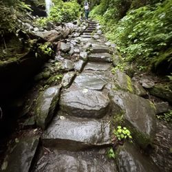
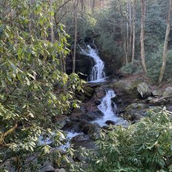
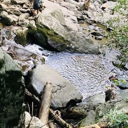
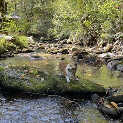
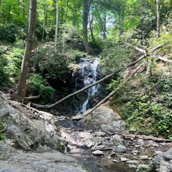
Alum Cave Trail Photos


You might also consider
More like Alum Cave Trail
Recommended Reviews - Alum Cave Trail
Start your review...

Reviews With Photos

Probably the best trail in the park. We had trouble finding parking spots in the main lot and had to do a double take later to find an empty spot. This trail is unfortunately an out and back, which is a bummer. We hiked 11-12 miles all the way to the top of Mount Le Conte and back and saw the nice view. Overall, the trail is well maintained and has 3-4 nice scenery points to take pictures and there's plenty of water feature along the hiking trail, especially if you enjoy seeing lots of moss.

Spectacular hiking on this trail in the GSMNP. it's one of the more popular hikes as evidenced by the full parking lot and overflow along the road leading to the trailhead from both directions. My recent visit yield early fall colors popping out through the green backdrop. There are some challenging spots where cables are available as handholds. Arch cave is a great spot to take a snack break, listen to the creek, and to appreciate the beauty that can be found in GSMNP. Inspiration point is a rock ledge that gives you a view of chimney tops. Stay close and lean back to contemplate more about the magnificence of GSMNP, only if there is not a long trail of hikers waiting to cross. Finally this steady uphill climb brings you to the aforementioned Alum Cave Bluffs. This sandy alcove reminds me a little of the bluffs and caves of Cappadocia minus the frescos. Pack water and snacks. Remember to pack out your trash. Hiking poles are helpful but not necessary. Good sneakers or hiking shoes a must. Please leave your fancy purses at home. If you're an early hiker, you will have plenty of time to continue upwards to Mt LeConte.

This is a fun and gorgeous trail. 5 miles out and back for a total of 10 miles to the peak. The top is windy and cold so bring a jacket. This trail is definitely one of the harder ones in the park. Most people turn around at the cave and don't go all the way to the peak. Get there early to beat the crowds, by11 the parking lot is full. There is an overflow lot too.

Absolutely beautiful trail! Rapids, waterfalls, the trail runs through a rock and then climbs to spectacular overlooks and an amazing bluff! Challenging, but not incredibly tough and probably easy enough for a casual hiker to get up to at least the bluff. Even just a quick hike to a mile in will offer up some beautiful nature scenes, just be sure to get there early as it gets PACKED by 11:00a.

They say, 'third time is the charm' The first two times I hiked the Alum Cave Trail it ended in failure for me. On my third attempt I made it to Arch Rock, Inspiration Point, the Bluffs, and the caves at the top. I walked a total of 4.6 miles. That may not seem like a lot to some people, but it is to me. Walking 5 miles in Florida I can do easily, there are no Hills in Florida. This hike definitely challenged me, I was how breathing hard at different points, but I made it to the top. Let me tell you, the journey to get to the top is filled with beautiful forest, streams, Bridges, steps, and amazing views. I'm glad I conquered my inability to finish this adventure. I'm going to challenge myself to do more and more hikes. The Great Smoky Mountains National Park is incredible.

With a lot of convincing and guilt tripping, I headed into this trail with a belly full of breakfast, coffee, and flapjacks. It definitely paid off and I don't regret going on this trail slightly sick in the rain, because it is so beautiful! If your body is able to handle it, definitely take on this challenge early on in the AM if you are ever in the Smokies. It's got changing landscapes, biodiversity, lush green all around, and fantastic views from one of the tallest mountain peaks in the Smokies. The lodge awaits you on top, where you can get a cookie, coffee, hot chocolate, and lunch bags in the dining hall. The climb down is easier than the climb up, but make sure you're good on time before the sun sets - you don't want to be on this trail in the dark.

I'm so different from my biological family. My mother and sisters have absolutely no sense of adventure. While new things and places excite me sometimes to the point of a superb bowel movement, it does the same for my siblings, but out of fear of trying anything new. Literally if I see something my wife knows excites me, she will ask me "do you gotta poop?" Typically this happens when we are watching travel shows and see an amazing destination. So, over my adult life I have created my own unique family. I have drawn people to my life that have become my family in ways my natural family could never be. One such person is our yelp friend Jess. I met her in 2018 at a yelp event where we instantly became buddies. 2 years later, we affectionately refer to her as "our hiking daughter". So, when I told her we were planning a trip to Gatlinburg to hike Mount LeConte, she was eager to go! ~ THE EXPERIENCE 2020 It was a hard sell to get my wife to hike this trail, but it was much more convincing to have a nearly all female hiking crew! There was my wife, Jess, PollyAnna, Erica and her 11-year-old son Zeke. We began our day with a hearty 7am breakfast @ Crockett's and were on the trail promptly @ 8am. Here is an account of our times, keeping in mind none of us were in any real shape as we pass through this COVID-19 SEASON of restrictions: BEGAN HIKE @ 8am Reached Arch Rock @ 8:45am Reached Inspiration Point @ 9:13am Reached Alum Cave @ 9:25am (paused to take pics) Reached LeConte Lodge @ 11:40am (did not stop) ATE LUNCH NEAR CLIFFS @ 12:15pm (very windy & cold) * We purchased 12" Subway sandwiches & chips the night before. Reached summit @ 12:40pm Reached Myrtle Point @ 12:50pm RELAXED FOR ABOUT 1/2 hour (so cold) Stopped @ LeConte Lodge for restrooms & T-shirts Returned to car @ 4:35pm (began raining) TOTAL HIKE TIME: 8 hours : 35 minutes NOTE: Temperature difference felt 15-20 degrees colder on the mountaintop than at the parking area. We didn't really require jackets along the hike, but they were much needed on top! ~ FINAL THOUGHTS Our smart phones all registered a distance of about 15 miles from beginning to end with my iPhone claiming I climbed 124 floors. However, all the trail guides I've read say the hike to the summit is only 5.5 miles with a gain of about 2,800 feet (200 stories if using 14' as a standard story). I also verified the length of the trail using the measurement feature on Google Maps and it too verifies the distance from parking to the summit @ 5.5 miles and Myrtle Point @ 5.72 miles giving our hiking distance a grand total of 11.44 miles. We were super sore by the time we returned from our hike and for several days afterwards, but what an incredible experience! I'm so glad my wife joined me so that we can say we did this together! At 6,594 feet, Mount LeConte is the 6th tallest peak east of the Mississippi and only 90 feet shorter than the tallest peak (Mount Mitchell). TIPS: Bring food, snacks and at least a 20oz Gatorade + 3 bottles of water per person! Also, eat a meal first & arrive as early as possible! We arrived @ 7:50am and most of the parking at the trailhead was full. Restroom facility can have a line on busy days. Lodge at the top does have restrooms (albeit smelly ones). ENJOY! 2020 / 70


This is a more strenuous hike. After doing a different 5 mile hike the previous day, I wanted to do another one. This one definitely has gorgeous views but it is mostly at an incline to the cave and has several portions of the trail that are just rock. You know you're almost there when you get to the never-ending stairs. Would have liked to go to the summit, but I was too exhausted. Next time!
")
Outstanding! Beautiful fall foliage. Started out easy and got more challenging as it progressed. Many steps, many turns and many adorable (sturdy) bridges. You go under/up a tunnel about half way to the cove. Just when you think you have seen the most amazing scenery... it gets way better. Just when you think you can't go anymore, you are at the cove and you can sit, catch your breath and enjoy amazing views. Pack a bite to eat (we wish we had) and stay hydrated. Then proceed onward to see even more worthwhile views! It took us an hour almost exactly to get to the top. Going down was easy after our knees got used to the change in direction! ENJOY!!!!!


We did this trail to Mt Leconte and up to Myrtle Point. Parking can get tricky if you get there late, we got there at 930am and we had to park 0.2 miles out. (So get there before9 am). The hike is hard (for me) and about a total of 13.5 miles. The first 1.5 miles is good and easy. At around mile 2 it goes uphill and rarely stops. It can be nonstop uphill with stairs and rocks. Lots of stairs. The cave and cliffs and the top are worth it, in my opinion. It's very hard, you'll need lots of water, snacks and breaks to rest. If you can physically do it, then do it. If it rains it can get slippery so be careful. Wear good shoes and you may need hiking sticks. Use sun screen and bug repellent. At the top of Mt LeConte, there is lodge people stay at, it's cabin and very basic, smelly "toilets", those are gross. There is a shorter Cliff top views trail that's 0.2mikes but we didn't do that. We got a small snack at the lodge. There is also well water there to refill and drink, it's good! The trail is well tracked but has some areas close to the edge with rocks, not hard but don't look down. There is a rope in the side incase and it's just 10 steps. We loved the hike! Enjoy :) make sure you go online and read about the hike and elevation gain (more than 2000ft).

9 months ago
Today was our second time back to Alum Cave Trail, and we did the 2.3 miles to Alum Cave Bluff and then turned back, for a total of 4.6 miles. You can go on for a total of five miles to reach Mt. Leconte, but since the weather was turning and it was starting to rain we cut our hike short. Like others, I suggest getting to this trail head early, as at 7:30 am half the parking lot was full!! We love this trail in particular for its endless water features, lots of scenic spots to take pictures, unique bridges, and the breathtaking view from the top. Even with the bad weather today, it was something spectacular watching the fog lift above the golden trees. If you haven't been, this trail is definitely worth your time and attention. You will want to wear some sturdy walking shoes for this one and maybe even bring a walking stick!! read more


8 months ago
Gorgeous trail with diverse beauty. We did the medium length hike to the bluff and loved it. Once you pass the cave the whole hike is pretty much going uphill so come prepared to get a workout in and wear proper shoes and bring some water. The views are great from the bluff and totally worth it. We came during the week around noon and parking lot was full so we had to park further out and walk about a half mile or so to the trail so be prepared for that or plan your time. Totally worth it! One of my favorite hikes that we did in the area. Loved being by the creek, the log crossings, the cave, the moss, the trees, and the Mountain Views. the scenery was so pretty. There is a bathroom on-site at the start of the trail in case you are wondering. read more


Remarkable! Outstanding views, winding paths, tons of stairs, and nature in all of its beauty! My group was ready! Surprises: 1- Bridges with one sided handrails! 2- Being in the clouds once we reached the cave! It rained off & on and it was slippery at a few points. Arrive early for the best parking options and to beat the crowds! read more


Probably the best trail in the park. We had trouble finding parking spots in the main lot and had to do a double take later to find an empty spot. This trail is unfortunately an out and back, which is a bummer. We hiked 11-12 miles all the way to the top of Mount Le Conte and back and saw the nice view. Overall, the trail is well maintained and has 3-4 nice scenery points to take pictures and there's plenty of water feature along the hiking trail, especially if you enjoy seeing lots of moss. read more


Spectacular hiking on this trail in the GSMNP. it's one of the more popular hikes as evidenced by the full parking lot and overflow along the road leading to the trailhead from both directions. My recent visit yield early fall colors popping out through the green backdrop. There are some challenging spots where cables are available as handholds. Arch cave is a great spot to take a snack break, listen to the creek, and to appreciate the beauty that can be found in GSMNP. Inspiration point is a rock ledge that gives you a view of chimney tops. Stay close and lean back to contemplate more about the magnificence of GSMNP, only if there is not a long trail of hikers waiting to cross. Finally this steady uphill climb brings you to the aforementioned Alum Cave Bluffs. This sandy alcove reminds me a little of the bluffs and caves of Cappadocia minus the frescos. Pack water and snacks. Remember to pack out your trash. Hiking poles are helpful but not necessary. Good sneakers or hiking shoes a must. Please leave your fancy purses at home. If you're an early hiker, you will have plenty of time to continue upwards to Mt LeConte. read more

3 years ago
This is a fun and gorgeous trail. 5 miles out and back for a total of 10 miles to the peak. The top is windy and cold so bring a jacket. This trail is definitely one of the harder ones in the park. Most people turn around at the cave and don't go all the way to the peak. Get there early to beat the crowds, by11 the parking lot is full. There is an overflow lot too. read more


Absolutely beautiful trail! Rapids, waterfalls, the trail runs through a rock and then climbs to spectacular overlooks and an amazing bluff! Challenging, but not incredibly tough and probably easy enough for a casual hiker to get up to at least the bluff. Even just a quick hike to a mile in will offer up some beautiful nature scenes, just be sure to get there early as it gets PACKED by 11:00a. read more


1 year ago
5 years ago
They say, 'third time is the charm' The first two times I hiked the Alum Cave Trail it ended in failure for me. On my third attempt I made it to Arch Rock, Inspiration Point, the Bluffs, and the caves at the top. I walked a total of 4.6 miles. That may not seem like a lot to some people, but it is to me. Walking 5 miles in Florida I can do easily, there are no Hills in Florida. This hike definitely challenged me, I was how breathing hard at different points, but I made it to the top. Let me tell you, the journey to get to the top is filled with beautiful forest, streams, Bridges, steps, and amazing views. I'm glad I conquered my inability to finish this adventure. I'm going to challenge myself to do more and more hikes. The Great Smoky Mountains National Park is incredible. read more


With a lot of convincing and guilt tripping, I headed into this trail with a belly full of breakfast, coffee, and flapjacks. It definitely paid off and I don't regret going on this trail slightly sick in the rain, because it is so beautiful! If your body is able to handle it, definitely take on this challenge early on in the AM if you are ever in the Smokies. It's got changing landscapes, biodiversity, lush green all around, and fantastic views from one of the tallest mountain peaks in the Smokies. The lodge awaits you on top, where you can get a cookie, coffee, hot chocolate, and lunch bags in the dining hall. The climb down is easier than the climb up, but make sure you're good on time before the sun sets - you don't want to be on this trail in the dark. read more


6 years ago
I'm so different from my biological family. My mother and sisters have absolutely no sense of adventure. While new things and places excite me sometimes to the point of a superb bowel movement, it does the same for my siblings, but out of fear of trying anything new. Literally if I see something my wife knows excites me, she will ask me "do you gotta poop?" Typically this happens when we are watching travel shows and see an amazing destination. So, over my adult life I have created my own unique family. I have drawn people to my life that have become my family in ways my natural family could never be. One such person is our yelp friend Jess. I met her in 2018 at a yelp event where we instantly became buddies. 2 years later, we affectionately refer to her as "our hiking daughter". So, when I told her we were planning a trip to Gatlinburg to hike Mount LeConte, she was eager to go! ~ THE EXPERIENCE 2020 It was a hard sell to get my wife to hike this trail, but it was much more convincing to have a nearly all female hiking crew! There was my wife, Jess, PollyAnna, Erica and her 11-year-old son Zeke. We began our day with a hearty 7am breakfast @ Crockett's and were on the trail promptly @ 8am. Here is an account of our times, keeping in mind none of us were in any real shape as we pass through this COVID-19 SEASON of restrictions: BEGAN HIKE @ 8am Reached Arch Rock @ 8:45am Reached Inspiration Point @ 9:13am Reached Alum Cave @ 9:25am (paused to take pics) Reached LeConte Lodge @ 11:40am (did not stop) ATE LUNCH NEAR CLIFFS @ 12:15pm (very windy & cold) * We purchased 12" Subway sandwiches & chips the night before. Reached summit @ 12:40pm Reached Myrtle Point @ 12:50pm RELAXED FOR ABOUT 1/2 hour (so cold) Stopped @ LeConte Lodge for restrooms & T-shirts Returned to car @ 4:35pm (began raining) TOTAL HIKE TIME: 8 hours : 35 minutes NOTE: Temperature difference felt 15-20 degrees colder on the mountaintop than at the parking area. We didn't really require jackets along the hike, but they were much needed on top! ~ FINAL THOUGHTS Our smart phones all registered a distance of about 15 miles from beginning to end with my iPhone claiming I climbed 124 floors. However, all the trail guides I've read say the hike to the summit is only 5.5 miles with a gain of about 2,800 feet (200 stories if using 14' as a standard story). I also verified the length of the trail using the measurement feature on Google Maps and it too verifies the distance from parking to the summit @ 5.5 miles and Myrtle Point @ 5.72 miles giving our hiking distance a grand total of 11.44 miles. We were super sore by the time we returned from our hike and for several days afterwards, but what an incredible experience! I'm so glad my wife joined me so that we can say we did this together! At 6,594 feet, Mount LeConte is the 6th tallest peak east of the Mississippi and only 90 feet shorter than the tallest peak (Mount Mitchell). TIPS: Bring food, snacks and at least a 20oz Gatorade + 3 bottles of water per person! Also, eat a meal first & arrive as early as possible! We arrived @ 7:50am and most of the parking at the trailhead was full. Restroom facility can have a line on busy days. Lodge at the top does have restrooms (albeit smelly ones). ENJOY! 2020 / 70 read more


What's not to love. Gorgeous never ending and breathtaking. Beautiful but not for the faint of heart. Lots of steps but worth the trike. Not the trail to start with if you have never hiked or are new to this sport. Work up to it. It's sure for worth it. read more


2 years ago
3 years ago
Moderately challenging hike in the Smoky mountains. En route to cliff tops and Myrtle point of the Mt. LeConte trail. Slippery and muddy in March and prone to road closures and high winds. read more


4 years ago
This is a more strenuous hike. After doing a different 5 mile hike the previous day, I wanted to do another one. This one definitely has gorgeous views but it is mostly at an incline to the cave and has several portions of the trail that are just rock. You know you're almost there when you get to the never-ending stairs. Would have liked to go to the summit, but I was too exhausted. Next time! read more

6 years ago
Outstanding! Beautiful fall foliage. Started out easy and got more challenging as it progressed. Many steps, many turns and many adorable (sturdy) bridges. You go under/up a tunnel about half way to the cove. Just when you think you have seen the most amazing scenery... it gets way better. Just when you think you can't go anymore, you are at the cove and you can sit, catch your breath and enjoy amazing views. Pack a bite to eat (we wish we had) and stay hydrated. Then proceed onward to see even more worthwhile views! It took us an hour almost exactly to get to the top. Going down was easy after our knees got used to the change in direction! ENJOY!!!!! read more
 - Hiking Near Me - Gatlinburg, Tennessee")


We did this trail to Mt Leconte and up to Myrtle Point. Parking can get tricky if you get there late, we got there at 930am and we had to park 0.2 miles out. (So get there before9 am). The hike is hard (for me) and about a total of 13.5 miles. The first 1.5 miles is good and easy. At around mile 2 it goes uphill and rarely stops. It can be nonstop uphill with stairs and rocks. Lots of stairs. The cave and cliffs and the top are worth it, in my opinion. It's very hard, you'll need lots of water, snacks and breaks to rest. If you can physically do it, then do it. If it rains it can get slippery so be careful. Wear good shoes and you may need hiking sticks. Use sun screen and bug repellent. At the top of Mt LeConte, there is lodge people stay at, it's cabin and very basic, smelly "toilets", those are gross. There is a shorter Cliff top views trail that's 0.2mikes but we didn't do that. We got a small snack at the lodge. There is also well water there to refill and drink, it's good! The trail is well tracked but has some areas close to the edge with rocks, not hard but don't look down. There is a rope in the side incase and it's just 10 steps. We loved the hike! Enjoy :) make sure you go online and read about the hike and elevation gain (more than 2000ft). read more

6 years ago
6 years ago
Man, this trail was beautiful! All around it was great. It was challenging enough to keep you on your toes, and beautiful scenery to not get too bored. I get SO bored walking and this trail kept my attention. I loved that you walk next to the creek for most of it! Dress in layers because I'm October it was chilly in the morning but warmed up later. This hike is on an incline and there are a lot of steps so be prepared. My knees are KILLING ME so worth it though read more


6 years ago
The Alum Cave Trail is the longest and by far the most difficult trail that I have ever hiked, but SO worth it. This hike is not for the weak, as it took our hiking group almost 9 hours from start to finish. Be sure to pack plenty of water, Gatorade, and snacks and wear your best hiking boots. There are some parts of the trail that are narrow and a wire cable is attached to side of the mountain to hold onto. What I really liked about this hike is that the views never stopped. We hiked this trail in early October and the fall colors were in full view. There was always something different and pretty to look at as you climb the mountain and tons of great photo opportunities along the way. Be sure to arrive early, as this is a popular hike in Gatlinburg. We arrived around 8 AM and the place was already pretty packed. There is a parking lot, but you will notice a long stretch of cars parked along the road as well. Arch Rock is the first landmark on the hike. I have never seen something so cool looking on a hike before! A log bridge leads you to the big rock, where you climb the stairs to take you to the other side. SO cool! Next up is Alum Cave, which is a vast area of dirt overshadowed by a huge wall of rock. It's pretty impressive to look at and you will look microscopic when you take a picture next to it. Again, I have never seen anything like this before. This is a great place to take a rest and water break, which we did. The next stop was the LeConte Lodge, which is where small cabins, a gift shop, and bathrooms are. I bought a cool t-shirt that said "I hiked Mt. LeConte" to remember my experience.I think is was $25. Keep walking past the lodge and you will see an area called The Cliffs. This was the spot we chose to eat lunch. I definitely had worked up an appetite and needed some hiking fuel. This is also where I started to notice a temperature difference. It was a least a 10 degree difference and very windy. Be sure to bring a jacket, because you will need it at the top. After lunch, we made our way to The Summit. I was so surprised that there were no views at the summit. It was just a pile rocks that hikers have stacked to increase the elevation. I added my rock to the pile and continued on to Myrtle Point. This is a few miles more and at his point in your hike you are tired and might consider skipping this part, BUT DON'T! This is where you will see the best views and it is also a great spot to sit and rest before making your way back down the mountain. For almost all of our hike we were so lucky to have perfect weather. There was only light rain for the last hour of our hike. The rest was sunny with a crisp breeze. At the end of this hike, you will be tired and sore, but you will feel a huge sense of accomplishment for sure. I know I sure did! read more


7 years ago
6 years ago
This trail was great! It is definitely worth it to make it to the top. A lot of cool views on the way up as well. read more


5 years ago
Gorgeous. GORGEOUS!! I was joining a group of friends in Pigeon Forge for a vacation. Unfortunately, I only had 1.5 days in the area and they had closer to 5. I wanted to get some hiking in, and a few of them wanted to join me, as long as it was a trail they hadn't done yet. So after a quick search of "best hiking trails in the Smoky Mountains", we found Alum Cave Trail. This was my first time ever in the area, and this was a wonderful introduction to the Smokies! The main trail, up to the "cave", is about 5 miles round trip. Half of it is pretty easy, up to the arch. Gorgeous scenery. And even on a cold and rainy/slightly snowy/almost hail-y day, there were plenty of people on the trail. After the arch, it gets steeper and more rugged. As long as you have a sense of adventure and time, you should be able to make it to the cave. I was a little nervous about the way back down, because it was a challenge on the way up. But it wasn't too bad! I was pleasantly surprised! There are many places with dripping water and wet areas of the path. So I would be hesitant to hike the trail in colder weather. The trail was easy to follow, and the vistas are spectacular! read more


7 years ago
This was a great hike! I will say it is a physical one. Lots of narrow bridges and about 1000' elevation from the parking area to the bluff. Great fun and spectacular views. read more


This is such a great hike. I wouldn't say it was easy by any means but it's so worth it. We hiked up to the cave, in the rain and it was such a great experience. So many friendly people and beautiful views. We started early in the morning so it wasn't too busy and very enjoyable. Just beware there are a lotttt of steps. Can't wait to do it again! read more


6 years ago
First time visiting Alum Cave Trail and it was amazing! Scenery was breathtaking. Starting off, the hike was fairly easy but a little long, we walked beside a river and the area was fairly shaded. Continuing on the way up to reach the Alum Bluff it got a bit more challenging becoming slightly steep. Before reaching the bluff there was an area with Mountain views that was breath taking! We stopped for a little break and took pictures there, and then after a 10-15 minute walk we reached the Alum Bluff. Reaching the bluff was very rewarding, and the rock formation was massive and neat to see. If wanting to continue the hike from the bluff- it takes to Mount Lecont which requires an additional 5 miles. Most hikers that went up told us it was very steep and intense. We wanted to continue, but it got a little late and we didn't have enough water so we headed back, but definitely important to plan in advance and to come early if wanting to go to Mount Lecont! Overall the 5 mile round trip hike to the bluff was beautiful and the scenery was magnificent! Can't wait to come back again! read more


7 years ago
My favorite trail in the smoky mountains. During February, there were icicles falling from the mountain - stunning! As you've might already guessed, I survived it. read more


7 years ago
Alum Cave Trail is a beautiful hike. I would say it is moderate in difficulty. The lovely part about this trail is that you can opt to keep hiking after the cave and make your way up to the Alum Cave Bluffs which is unlike anything I've seen before on a hike. You can actually keep hiking to the top of Mt. LeConte where there is lodging and you may very well end up hiking beside llamas who are designated to bring supplies up and down the mountain. I would recommend packing a lunch and eating it by the bluffs on a rock overlooking the Mountain View. The trail does get steep by the bluffs but it did not cause any problems for our group of 6. read more


9 years ago
It was kind of late in the day when we found this trail so we only did the first portion which was shown as a moderate hike. It was ever so slightly uphill consistently. I think it was about 1.5 miles (one way so 3 miles total) which they said should take about 45 minutes each way. I would say that was pretty accurate. It was one of my favorite hikes. Felt a little like a rainforest on the day we went and you are either walking along or over the water most of the time which is just beautiful to look at and hear. After the cave with the stairs in it you are on the second stretch of the hike which is a lot more strenuous you can tell right away but I'm pretty out of shape and think I could have managed had we had the time to continue. read more


6 years ago
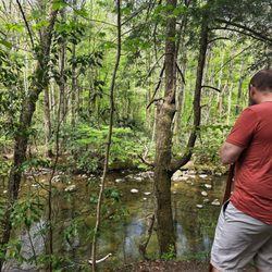
his trail was my husband's favorite trail in all of SMNP. The trail encapsulates everything that makes the Smoky Mountains beautiful which is why I would recommend it. The first mile and a half the trail runs alongside a clear mountain creek, one of the most scenic I have seen anywhere. There are many areas where it is easy to access the creek and just sit on a rock and listen to the rushing water--so peaceful. We only hiked the "flat" part up to and through the Arch, which I would rate as an easy hike. The trail is not paved, but well maintained and you cross a few bridges that are little wider than a log with a rail. The bridges and the arch added some unique features which made the trail more fun and interesting. There is more parking than at most trailheads in the park (a lot and an overflow lot) and the trailhead is easy to find right on the main road through the park (441). But since this trail is understandably extremely popular, you will encounter a lot of other hikers. We arrived on a weekday at noon (after waiting out a rainstorm) and with plenty of turnover in the parking lot, we were fortunate enough to get a good spot. Few people were wearing masks outside, but in our experience everyone was polite. Nobody crowded us, and people stepped to the side to pass, so we felt safe. I want to come back and hike the more challenging portions of the trail all the way up to Mount Leconte. read more


6 years ago
5 years ago
10 years ago
The hike itself was not so easy, but it was worth it in the end after making it to the "caves"! My family and I enjoyed the scenic trails up the mountains, and got some amazing shots of the views. I would definitely recommend trying this hike as it was truly unlike no other! read more

11 years ago
Very nice trail, you hike along the creek for about half of the trip. It took us 3 hours to do the round trip to the Bluff plus 30 mins lunch break. Narrow roads but worth the effort. read more


7 years ago
We headed out on the Alum Cave Trail with our 5, 8 and 11yo. Knew what we were getting into ahead of time and brought full camelpack of water, lots of snacks and PBJs and "power packs" aka Blowpops. We knew our 5yo was our weakest link so we prepped our other two about the "power packs". They did an AMAZING job! At less than 0.25 from the bluff, our 5yo was more than ready to turn around so she and my hubby turned around while my 8yo, 11yo and I trekked it all the way to the bluff. #proudmama It was worth it bc the hike is gorgeous the entire way. The first mile is a breathtaking bubbly and flowing creek. After that you hit panoramic vistas followed by the final destination, the bluff. Incredible hike that is highly recommend to those who are ready for an uphill constant battle with rocks, slippery surfaces and one person bridges. read more


8 years ago
8 years ago
10 years ago
Page 1 of 2
More info about Alum Cave Trail
Hwy 441
Gatlinburg, TN 37738
Directions
Hours
Outdoor Amenities
Ask the Community - Alum Cave Trail
Review Highlights - Alum Cave Trail
You might also consider


Alum Cave Trail - hiking - Updated July 2026
Best of Gatlinburg
People found Alum Cave Trail by searching for…
Hiking Trails With Waterfalls in Gatlinburg, Tennessee
Things to Do in Gatlinburg, Tennessee
Caves in Gatlinburg, Tennessee
Off Road Trails in Gatlinburg, Tennessee
Scenic Overlook in Gatlinburg, Tennessee
Scenic View in Gatlinburg, Tennessee
Parks in Gatlinburg, Tennessee
Places to Take Pictures in Gatlinburg, Tennessee
Secret Spots in Gatlinburg, Tennessee
Waterfall in Gatlinburg, Tennessee
Photo Spots in Gatlinburg, Tennessee
Natural Hot Springs in Gatlinburg, Tennessee
Tourist Attractions in Gatlinburg, Tennessee
Lookout Points in Gatlinburg, Tennessee
Walking Trails in Gatlinburg, Tennessee
Running Trails in Gatlinburg, Tennessee
Easy Hikes in Gatlinburg, Tennessee
Waterfalls and Swimming Holes in Gatlinburg, Tennessee
Things to Do on a Rainy Day in Gatlinburg, Tennessee
View Points in Gatlinburg, Tennessee
Dog Friendly Hiking Trails in Gatlinburg, Tennessee
Night Hike in Gatlinburg, Tennessee
Trending Searches in Gatlinburg, TN
Black Owned Nail Salons in Gatlinburg, TN
Cliff Jumping in Gatlinburg, TN
Dog Friendly Trails in Gatlinburg, TN
Jet Ski Rental in Gatlinburg, TN
Kayak Rental in Gatlinburg, TN
Lakes & Ponds in Gatlinburg, TN
Outdoor Activities in Gatlinburg, TN
Public Pools in Gatlinburg, TN
Public Shower in Gatlinburg, TN
River Swimming in Gatlinburg, TN
Running Trails in Gatlinburg, TN
Scenic Night View in Gatlinburg, TN
Scenic Overlook in Gatlinburg, TN
Secluded Spots in Gatlinburg, TN
Soccer Store in Gatlinburg, TN
Strawberry Picking in Gatlinburg, TN
Sunrise View in Gatlinburg, TN
Swimming Holes in Gatlinburg, TN
Swimming Lakes in Gatlinburg, TN
Swimming Pools in Gatlinburg, TN
Browse Articles
Browse Nearby
Browse Brands
Related Searches in Gatlinburg, TN
Affordable Kayak Rental Services in Gatlinburg, Tennessee
Best Fishing Locations and Guides in Gatlinburg, Tennessee
Best Nature Trails for Hiking in Gatlinburg, Tennessee
Best Places for Horseback Riding in Gatlinburg, Tennessee
Best Waterfalls and Swimming Holes in Gatlinburg, Tennessee
Check Out Off Road Trails in Gatlinburg, Tennessee
Discover Dog Friendly Trails to Explore in Gatlinburg, Tennessee
Discover Scenic Mountain Bike Trails Near Gatlinburg, Tennessee
Discover Scenic Waterfall Spots in Gatlinburg, Tennessee
Discover a Hiking Trail in Gatlinburg, Tennessee
Discover the Best Night Hike Trails in Gatlinburg, Tennessee
Discover the Best Running Track in Gatlinburg, Tennessee
Dog-Friendly Hikes With Dogs in Gatlinburg, Tennessee
Enjoy Camping Adventures Around Gatlinburg, Tennessee
Enjoy Exciting Mountain Biking Adventures in Gatlinburg, Tennessee
Enjoy Kayaking Adventures in Gatlinburg, Tennessee
Enjoy Tent Camping Spots Around Gatlinburg, Tennessee
Enjoy a Beautiful Waterfall Hike in Gatlinburg, Tennessee
Enjoy the Best Family Activities in Gatlinburg, Tennessee
Enjoy the Best Tubing Experiences in Gatlinburg, Tennessee
Enjoy the Best Walking Trails in Gatlinburg, Tennessee
Exciting Cliff Jumping Spots in Gatlinburg, Tennessee
Experience Thrilling White Water Rafting in Gatlinburg, Tennessee
Explore Beautiful Parks and Green Spaces in Gatlinburg, Tennessee
Explore Easy Hikes Perfect for All in Gatlinburg, Tennessee
Explore Fun Activities to Do in Gatlinburg, Tennessee
Explore Popular Campgrounds Near Gatlinburg, Tennessee
Explore the Best Boating Spots in Gatlinburg, Tennessee
Explore the Best Swimming Holes Around Gatlinburg, Tennessee
Explore the Best Trail Options in Gatlinburg, Tennessee
Family Friendly Hiking With Kids in Gatlinburg, Tennessee
Find Cozy Camping Cabins in Gatlinburg, Tennessee
Find Popular Ziplining Spots Around Gatlinburg, Tennessee
Find the Best Scenic View Locations in Gatlinburg, Tennessee
Hiking Trails With Waterfalls in Gatlinburg, Tennessee
Plan a Scenic Drive Route Near Gatlinburg, Tennessee
Popular Outdoor Activities to Try in Gatlinburg, Tennessee
Popular Picnic Spots to Visit in Gatlinburg, Tennessee
Popular Things to Do in Gatlinburg, Tennessee
Safe River Swimming Areas in Gatlinburg, Tennessee
Safe and Fun Parks for Kids in Gatlinburg, Tennessee
Top Climbing Spots and Gyms in Gatlinburg, Tennessee
Top Paddleboarding Activities in Gatlinburg, Tennessee
Top Places for Snorkeling in Gatlinburg, Tennessee
Top Running Trails to Explore in Gatlinburg, Tennessee
Top Swimming Lakes to Enjoy in Gatlinburg, Tennessee
Top Swimming Spots and Pools in Gatlinburg, Tennessee
Top Things to Do With Kids in Gatlinburg, Tennessee