Bass Cove Trail Photos


You might also consider
More like Bass Cove Trail
Recommended Reviews - Bass Cove Trail
Start your review...

A great trail on the west side of Lake Chabot!!! I'm lucky I live a quick drive away from here. This is one of my go to trails when I want to get a quick mid week hike in and I don't have a lot of time. I access this trail through Chabot Park, this trail is to the left. It's all dirt, small rolling hills until you get to the camp grounds. This trail doesn't always run right next to Lake Chabot, lots of curving in and out from the lake and back with small inclines and declines along the way. This trail is mostly used by walkers and bike riders, and it's a good way to just get away from it all, at least for a little while, or as long as you feel like it!! read more


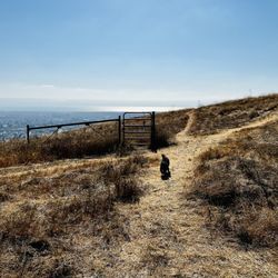
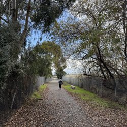
MY PHOTOGRAPHS. (1) View to the south, of a deep canyon. At the top of my photo, you can see the Bay-O-Vista neighborhood in San Leandro. (2) Later on, you pass a little peninsula of land, where people sometimes go fishing. Here and there by the water's edge there are thick patches of tall reeds. (3) Further along on Bass Cove Trail, there is a transition in the trail, where long branches from thousands of trees cover the entire trail, like a tunnel. (4) Gulch that is covered with arching trees, where the tree are covered with bright green moss. (5) Further along on Bass Cove Trail, you will encounter a second trail sign at a fork in the trail. The sign indicates the direction to Bass Cove, and the direction of Goldenrod Trail. I am posing in this photo. (6) Close up photo of one of the thousands of trees covered with bright green moss. (7) View of a beautiful little bay, located at the western edge of Lake Chabot. As you can see from this photograph, Bass Cove Trail is now about 200 feet above the Lake Chabot. (8) Photograph of several ducks. The ducks are swimming at the northern-most part of Bass Cove. BASS COVE TRAIL. The most direct access to Bass Cove Trail is by starting at the parking lot at the end of Estudillo Ave. The initial part of the hike is uphill and, once beyond the dam, it remains mostly level, where you are taking a clockwise route around Lake Chabot. Early in your hike, you will encounter a chain linked fence at the right side of the trail. Just beyond this fence is a very steep hill (almost a cliff) where a canyon resides at the bottom of the cliff. The view of the trees growing near the bottom of this canyon is beautiful. Dramatic photographs can be taken from the top of the very steep hill. Further along Bass Cove Trail, hikers will encounter a beach that has thick clusters of reeds. On occasion, one or two fishermen practice their fishing hobby near these reeds. A tiny restroom is at the edge of Bass Cove Trail, next to this beach. DISTINCTIVE STYLE OF BASS COVE TRAIL. From the beach with reeds, all the way to the northern-most area of Bass Cove, the trail consists of about 20 loops that loop inland and away from the lake, and about 20 loops that loop towards the lake. The trail loops inland where there is a gulch (the gulch is like a notch in the mountain, and the trail takes you through this notch). The trail loops towards the lake, wherever a narrow hill extends from the mountain to the west. This extending hill is sort of like an arm reaching out from the mountain to the west (here, the trail allows you to skirt this arm, and to walk around the extending arm). When hiking northwards, the gulches to your left provide opportunities for taking photographs of moss-covered trees and bushy clusters of ferns. To the right side of the trail, which is filled with gnarly-looking trees, some of them covered with electric-green moss. Because the brightly-lit waters of Lake Chabot are in back of the gnarly trees, the outlines of the gnarly trees are easier to see. DUCKS. My 300 millimeter telephoto lens enabled me to take several photographs of the ducks that make their home at the northern-most area of Bass Cove. This northern-most area had another cluster of reeds. Once at this northern-most area, hikers have the choice of continuing their clockwise hike around Lake Chabot, or continuing in the northwards direction on a straight trail (not a loop trail) that follows along Grass Valley Creek. HUMOR WHILE HIKING. Near the end of my return hike, I noticed two women walking uphill towards me, and one of them was wearing a long coat with an unusual color. I paused in my walk and said, "Can you tell me the color of your coat? I know that it is not pink or scarlet." Then, the woman with the brightly colored coat answered, "It is fuchsia ! ! !" Within a blink of an eye, I replied, "Oh, I was so CONFUCHED ! ! !" The two ladies responded with a cascade of merry laughs. Then, I continued my walk, and I was glad that their response had made my day. read more


More info about Bass Cove Trail
Chabot Park
San Leandro, CA 94577
Directions
Hours
Outdoor Amenities
You might also consider


Bass Cove Trail - hiking - Updated July 2026
Best of San Leandro
People found Bass Cove Trail by searching for…
Beaches in San Leandro, California
Hiking Trails in San Leandro, California
Parks in San Leandro, California
Swimming Lakes in San Leandro, California
Fishing in San Leandro, California
Beautiful Views in San Leandro, California
Walking Trails in San Leandro, California
Trails in San Leandro, California
Waterfall Hike in San Leandro, California
Easy Hikes in San Leandro, California
Scenic Places to Walk in San Leandro, California
Lakes & Ponds in San Leandro, California
Free Things to Do in San Leandro, California
Walking Groups in San Leandro, California
Secluded Spots in San Leandro, California
Duck Pond in San Leandro, California
Creeks in San Leandro, California
Night Hike in San Leandro, California
Fishing Lakes in San Leandro, California
Running Trails in San Leandro, California
Scenic View in San Leandro, California
Secret Spots in San Leandro, California
Trending Searches in San Leandro, CA
4th Of July Fireworks near Bass Cove Trail
Black Owned Nail Salons near Bass Cove Trail
Boat Rental near Bass Cove Trail
Cliff Jumping near Bass Cove Trail
Day Trips near Bass Cove Trail
Fireworks near Bass Cove Trail
Jet Ski Rental near Bass Cove Trail
Kayak Rental near Bass Cove Trail
Lakes & Ponds near Bass Cove Trail
Off Road Trails near Bass Cove Trail
Outdoor Activities near Bass Cove Trail
Parks For Picnics near Bass Cove Trail
Places To Walk Around near Bass Cove Trail
Public Pools near Bass Cove Trail
Public Shower near Bass Cove Trail
River Swimming near Bass Cove Trail
Rock Quarry near Bass Cove Trail
Scenic Night View near Bass Cove Trail
Scenic Overlook near Bass Cove Trail
Secluded Spots near Bass Cove Trail
Soccer Store near Bass Cove Trail
Splash Pad near Bass Cove Trail
Strawberry Picking near Bass Cove Trail
Sunrise View near Bass Cove Trail
Swimming Holes near Bass Cove Trail
Swimming Lakes near Bass Cove Trail
Watch Sunset near Bass Cove Trail
Browse Articles
Browse Nearby
BEST of San Leandro, California Coffee near Bass Cove Trail
BEST of San Leandro, California Restaurants near Bass Cove Trail
BEST of San Leandro, California Things to Do near Bass Cove Trail
BEST of San Leandro, California Walking Trails near Bass Cove Trail
BEST of San Leandro, California Breakfast near Bass Cove Trail
BEST of San Leandro, California Parks near Bass Cove Trail
BEST of San Leandro, California Hot Springs near Bass Cove Trail
BEST of San Leandro, California Campgrounds near Bass Cove Trail
BEST of San Leandro, California Day Trips near Bass Cove Trail
Browse Brands
Related Searches in San Leandro, CA
Affordable Kayak Rental Services in San Leandro, California
Best Fishing Locations and Guides in San Leandro, California
Best Nature Trails for Hiking in San Leandro, California
Best Places for Horseback Riding in San Leandro, California
Check Out Off Road Trails in San Leandro, California
Discover Dog Friendly Trails to Explore in San Leandro, California
Discover Kid Friendly Hiking Trails in San Leandro, California
Discover Scenic Hiking Trails in San Leandro, California
Discover Scenic Mountain Bike Trails Near San Leandro, California
Discover Scenic Waterfall Spots in San Leandro, California
Discover Walking Parks in San Leandro, California Near You
Discover a Hiking Trail in San Leandro, California
Discover the Best Night Hike Trails in San Leandro, California
Discover the Best Running Track in San Leandro, California
Dog-Friendly Hikes With Dogs in San Leandro, California
Enjoy Camping Adventures Around San Leandro, California
Enjoy Kayaking Adventures in San Leandro, California
Enjoy Tent Camping Spots Around San Leandro, California
Enjoy a Beautiful Waterfall Hike in San Leandro, California
Enjoy a Peaceful Nature Walk in San Leandro, California
Enjoy the Best Picnic Spots and Ideas in San Leandro, California
Enjoy the Best Walking Path in San Leandro, California
Enjoy the Best Walking Trails in San Leandro, California
Explore Beautiful Parks and Green Spaces in San Leandro, California
Explore Easy Hikes Perfect for All in San Leandro, California
Explore Fun Activities to Do in San Leandro, California
Explore Popular Campgrounds Near San Leandro, California
Explore the Best Beach Spots in San Leandro, California
Explore the Best Swimming Holes Around San Leandro, California
Explore the Best Trail Options in San Leandro, California
Family Friendly Hiking With Kids in San Leandro, California
Find Beautiful Views in San Leandro, California
Find the Best Parks for Picnics in San Leandro, California
Find the Best Scenic View Locations in San Leandro, California
Great Places to Walk in San Leandro, California
Hike the Popular Waterfall Trail in San Leandro, California
Hiking Trails With Waterfalls in San Leandro, California
Off Leash Dog Hiking Trails in San Leandro, California
Plan a Scenic Drive Route Near San Leandro, California
Popular Outdoor Activities to Try in San Leandro, California
Popular Picnic Spots to Visit in San Leandro, California
Safe River Swimming Areas in San Leandro, California
Safe and Fun Parks for Kids in San Leandro, California
Top Climbing Spots and Gyms in San Leandro, California
Top Paddleboarding Activities in San Leandro, California
Top Running Trails to Explore in San Leandro, California
Top Swimming Lakes to Enjoy in San Leandro, California
Top Swimming Spots and Pools in San Leandro, California
Walk Dog Friendly Hiking Trails in San Leandro, California
Walk the Best Paved Walking Trails in San Leandro, California
People who viewed Bass Cove Trail also viewed
High Ridge Loop Trail
1 review
San Lorenzo Trail
15 reviews
Bay Farm Island Shoreline Trail
20 reviews
Golden Spike Trail
2 reviews
Loop along High Ridge Tr., Pioneer Tr., Meyer's Ranch Tr.
3 reviews
Children's Memorial Grove
5 reviews
Hayward Memorial Park
12 reviews
Upper San Leandro Reservoir
10 reviews
Tower Hiking Trail
1 review
East Ave Park
12 reviews