Big Dune Photos


More like Big Dune
Recommended Reviews - Big Dune
Start your review...

6 years ago
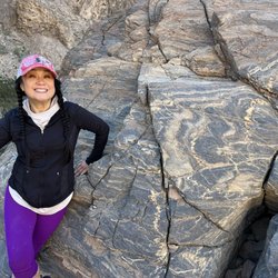
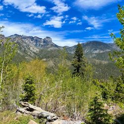
Absolutely love this place! You can walk, hike, bike, sit, etc. here. The views are super scenic and it's a very relaxing spot. I can't wait to get back here again! read more


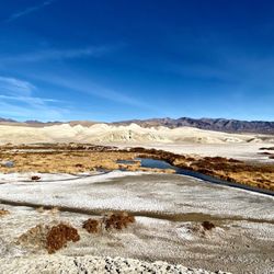
Along Route 95 in Amargosa Valley there isn't much. It has the alien themed travel center. There's a lot to do there if you know what I mean. Just past it is a natural area. There's no paved roads off the highway so be prepared. Big Dune is just that. It's big. This is easy to see from the road. It's a dune. This is a massive pile of sand. You can only get to it by taking unpaved roads, which can be some pretty rough terrain. Be careful with all the rocks you drive over. You don't want to get a flat tire. I would never take my personal car. If you want to get closer you should get an ATV. Mountain bikes would be good too. read more

Monday Tuesday Wednesday....no one out here 1 hour 45 from Vegas Yes it is a great spot for sandboarding and atvs. There is a gas station about 20 minutes away to gwt sandwiches drinks and such. Typically no one is here except on the weekends read more

5 years ago
3 years ago
More info about Big Dune
Amargosa Valley, NV 89020
Directions
Hours
Outdoor Amenities
Ask the Community - Big Dune


Why does Yelp recommend reviews?
1 review that is not currently recommended
The reviews below are not factored into the business's overall star rating.
6 years ago
Big Dune - hiking - Updated July 2026
Best of Amargosa Valley
People found Big Dune by searching for…
Things to Do in Amargosa Valley, NV
Sand Dunes in Amargosa Valley, NV
Natural Hot Springs in Amargosa Valley, NV
Dinosaur Park in Amargosa Valley, NV
Secret Spots in Amargosa Valley, NV
Off Road Trails in Amargosa Valley, NV
Mountain Biking in Amargosa Valley, NV
Scenic View in Amargosa Valley, NV
Easy Hikes in Amargosa Valley, NV
Scenic Drive in Amargosa Valley, NV
Sunrise View in Amargosa Valley, NV
Night Hike in Amargosa Valley, NV
Running Trails in Amargosa Valley, NV
What to Do in Amargosa Valley, NV
Arts & Entertainment in Amargosa Valley, NV
Walking Trails in Amargosa Valley, NV
Bike Trails in Amargosa Valley, NV
Stargazing in Amargosa Valley, NV
Camping in Amargosa Valley, NV
Hiking With Kids in Amargosa Valley, NV
Waterfalls and Swimming Holes in Amargosa Valley, NV
Browse Nearby
BEST of Amargosa Valley, Nevada Things to Do near Big Dune
BEST of Amargosa Valley, Nevada Restaurants near Big Dune
BEST of Amargosa Valley, Nevada Coffee near Big Dune
BEST of Amargosa Valley, Nevada Lakes near Big Dune
BEST of Amargosa Valley, Nevada Campgrounds near Big Dune
BEST of Amargosa Valley, Nevada Visitor Centers near Big Dune
BEST of Amargosa Valley, Nevada Horseback Riding near Big Dune


