
Cactus Loop Trail Photos


You might also consider
More like Cactus Loop Trail
Recommended Reviews - Cactus Loop Trail
Start your review...

1 year ago
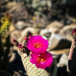
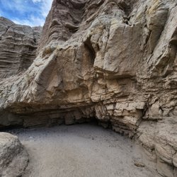
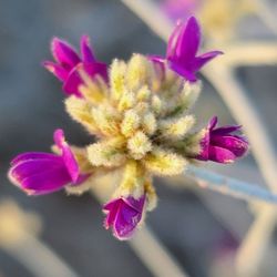
This is a really great spot for anyone who wants to see the scenic desert view and a wide variety of exotic cacti. First off, I like that it is on a slight elevation, so it isn't as hot as some of the nearby desert flats in the Mojave. It isn't too long either, only about 3/4 of a mile, so you aren't out in the heat. But within this distance, it is PACKED with thousands of cactus plants in large colonies. Along the hike, I saw six main species: Teddy Bear Cholla Beavertail Prickly Pear Compass/Fire Barrel Fishook Cactus Golden Cholla Engleman Hedgehog read more
More info about Cactus Loop Trail
Yaqui Pass Rd
Borrego Springs, CA 92004
Directions
(760) 767-4037
Call Now
Hours
Outdoor Amenities
You might also consider


Cactus Loop Trail - hiking - Updated July 2026
Best of Borrego Springs
People found Cactus Loop Trail by searching for…
Sunset View in Borrego Springs, CA
Running Trails in Borrego Springs, CA
Scenic Drive in Borrego Springs, CA
Hiking Trails in Borrego Springs, CA
Things to Do in Borrego Springs, CA
Beautiful Views in Borrego Springs, CA
Picnic Areas in Borrego Springs, CA
Walking Trails in Borrego Springs, CA
Scenic View in Borrego Springs, CA
Photo Spots in Borrego Springs, CA
Picnic Spots in Borrego Springs, CA
Off Leash Dog Hikes in Borrego Springs, CA
Easy Hikes in Borrego Springs, CA
Tourist Attractions in Borrego Springs, CA
Attractions in Borrego Springs, CA
View Points in Borrego Springs, CA
Waterfalls and Swimming Holes in Borrego Springs, CA
State Park in Borrego Springs, CA
Basketball in Borrego Springs, CA
Park and Ride in Borrego Springs, CA
Night View in Borrego Springs, CA
Fishing Spots in Borrego Springs, CA
Trending Searches in Borrego Springs, CA
Berry Picking near Cactus Loop Trail
Cliff Jumping near Cactus Loop Trail
Day Trips near Cactus Loop Trail
Free Picnic Areas near Cactus Loop Trail
Fruit Picking near Cactus Loop Trail
Lavender Farm near Cactus Loop Trail
Lookout Points near Cactus Loop Trail
Off Road Trails near Cactus Loop Trail
Outdoor Activities near Cactus Loop Trail
Peach Picking near Cactus Loop Trail
Picnic Spots near Cactus Loop Trail
Pool Day Pass near Cactus Loop Trail
Public Shower near Cactus Loop Trail
River Swimming near Cactus Loop Trail
River Tubing near Cactus Loop Trail
Scenic Overlook near Cactus Loop Trail
Swimming Holes near Cactus Loop Trail
Swimming Lakes near Cactus Loop Trail
U Pick Farms near Cactus Loop Trail
Browse Articles
Browse Nearby
BEST of Borrego Springs, California Things to Do near Cactus Loop Trail
BEST of Borrego Springs, California Restaurants near Cactus Loop Trail
BEST of Borrego Springs, California Coffee near Cactus Loop Trail
BEST of Borrego Springs, California Breakfast near Cactus Loop Trail
BEST of Borrego Springs, California Shopping near Cactus Loop Trail
BEST of Borrego Springs, California Thrift Stores near Cactus Loop Trail
BEST of Borrego Springs, California Visitor Centers near Cactus Loop Trail
Browse Brands
Related Searches in Borrego Springs, CA
Best Dog Hiking Trails Around Borrego Springs, California
Best Fishing Locations and Guides in Borrego Springs, California
Best Off Leash Dog Parks in Borrego Springs, California
Best Parks for Parties and Events in Borrego Springs, California
Best Places for Horseback Riding in Borrego Springs, California
Best Sightseeing Experiences Available in Borrego Springs, California
Best Water Parks for Kids in Borrego Springs, California
Best Waterfalls and Swimming Holes in Borrego Springs, California
Check Out Great Playgrounds in Borrego Springs, California
Check Out Off Road Trails in Borrego Springs, California
Discover Baseball Fields Around Borrego Springs, California
Discover Dog Friendly Trails to Explore in Borrego Springs, California
Discover Popular Photo Spots in Borrego Springs, California
Discover Scenic Mountain Bike Trails Near Borrego Springs, California
Discover Top Nature Parks to Visit in Borrego Springs, California
Discover Top State Parks to Visit in Borrego Springs, California
Discover a Hiking Trail in Borrego Springs, California
Discover the Best Beaches in Borrego Springs, California
Discover the Best Night Hike Trails in Borrego Springs, California
Dog-Friendly Hikes With Dogs in Borrego Springs, California
Enjoy Camping Adventures Around Borrego Springs, California
Enjoy Exciting Mountain Biking Adventures in Borrego Springs, California
Enjoy Off Leash Dog Hikes in Borrego Springs, California
Enjoy Tent Camping Spots Around Borrego Springs, California
Enjoy a Beautiful Waterfall Hike in Borrego Springs, California
Enjoy the Best Picnic Spots and Ideas in Borrego Springs, California
Enjoy the Best Walking Trails in Borrego Springs, California
Experience Stunning Sunset Views in Borrego Springs, California
Explore Beautiful Parks and Green Spaces in Borrego Springs, California
Explore Easy Hikes Perfect for All in Borrego Springs, California
Explore Free Picnic Areas Around Borrego Springs, California
Explore Fun Activities to Do in Borrego Springs, California
Explore Parks With Pull Up Bars in Borrego Springs, California
Explore Picnic Parks Near Borrego Springs, California
Explore Popular Campgrounds Near Borrego Springs, California
Explore Popular Picnic Areas Around Borrego Springs, California
Explore Popular RV Parks Around Borrego Springs, California
Explore Popular Scenic Overlook Points in Borrego Springs, California
Explore Scenic Lakes to Visit in Borrego Springs, California
Explore Top Dog Parks in Borrego Springs, California Near You
Explore Top Water Parks in Borrego Springs, California Today
Explore the Best Swimming Holes Around Borrego Springs, California
Family Friendly Hiking With Kids in Borrego Springs, California
Find Cozy Camping Cabins in Borrego Springs, California
Find Great Places to Feed Ducks in Borrego Springs, California
Find Parks and Recreation Activities in Borrego Springs, California
Find Popular Ziplining Spots Around Borrego Springs, California
Find Top Dog Friendly Parks to Visit in Borrego Springs, California
Find Top Skate Parks in Borrego Springs, California for All Skill Levels