Cascade Falls Photos


More like Cascade Falls
Recommended Reviews - Cascade Falls
Start your review...

1 year ago
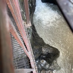
Loved it! Got to cool off with the spray coming off the falls! The kids loved it and you can walk right up to it. read more


More info about Cascade Falls
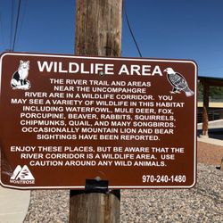
598 8th Ave
Ouray, CO 81427
Directions
(970) 325-4746
Call Now
Hours
Outdoor Amenities


Cascade Falls - hiking - Updated June 2026
Best of Ouray
People found Cascade Falls by searching for…
Trending Searches in Ouray, CO
Boat Rental near Cascade Falls
Fishing Spots near Cascade Falls
Kayak Rental near Cascade Falls
Playgrounds near Cascade Falls
Public Shower near Cascade Falls
Scenic Drive near Cascade Falls
Swimming Holes near Cascade Falls
Swimming Lakes near Cascade Falls
Watch Sunset near Cascade Falls
Browse Articles
Browse Nearby
BEST of Ouray, Colorado Parks near Cascade Falls
BEST of Ouray, Colorado Restaurants near Cascade Falls
BEST of Ouray, Colorado Coffee near Cascade Falls
BEST of Ouray, Colorado Things to Do near Cascade Falls
BEST of Ouray, Colorado Waterfalls near Cascade Falls
BEST of Ouray, Colorado Caves near Cascade Falls
BEST of Ouray, Colorado Campgrounds near Cascade Falls
Browse Brands
Related Searches in Ouray, CO
Best Fishing Locations and Guides in Ouray, Colorado
Best Fun Things to Do in Ouray, Colorado
Best Nature Trails for Hiking in Ouray, Colorado
Best Places for Horseback Riding in Ouray, Colorado
Best Sledding Spots and Fun in Ouray, Colorado
Best Water Parks for Kids in Ouray, Colorado
Best Waterfalls and Swimming Holes in Ouray, Colorado
Check Out Great Playgrounds in Ouray, Colorado
Check Out Off Road Trails in Ouray, Colorado
Discover Popular Bike Trails in Ouray, Colorado
Discover Scenic Waterfall Spots in Ouray, Colorado
Discover Top Nature Parks to Visit in Ouray, Colorado
Discover a Hiking Trail in Ouray, Colorado
Discover the Best Fishing Lake in Ouray, Colorado
Dog-Friendly Hikes With Dogs in Ouray, Colorado
Enjoy Camping Adventures Around Ouray, Colorado
Enjoy Exciting Mountain Biking Adventures in Ouray, Colorado
Enjoy Tent Camping Spots Around Ouray, Colorado
Enjoy the Best Picnic Spots and Ideas in Ouray, Colorado
Enjoy the Best Tubing Experiences in Ouray, Colorado
Experience Stunning Sunset Views in Ouray, Colorado
Explore Beautiful Parks and Green Spaces in Ouray, Colorado
Explore Bike Rentals Throughout Ouray, Colorado
Explore Free Picnic Areas Around Ouray, Colorado
Explore Free Things to Do Around Ouray, Colorado
Explore Fun Activities to Do in Ouray, Colorado
Explore Landmarks & Historical Buildings in Ouray, Colorado
Explore Nature Spots Around Ouray, Colorado
Explore Popular Campgrounds Near Ouray, Colorado
Explore Popular Picnic Areas Around Ouray, Colorado
Explore Popular RV Parks Around Ouray, Colorado
Explore Popular Scenic Overlook Points in Ouray, Colorado
Explore Popular Scenic Views Near Ouray, Colorado
Explore Popular View Points Around Ouray, Colorado
Explore Scenic Lakes to Visit in Ouray, Colorado
Explore Secret Spots Worth Visiting in Ouray, Colorado
Explore Summer Camps for All Ages in Ouray, Colorado
Explore Top Dog Parks in Ouray, Colorado Near You
Explore Top Gyms in Ouray, Colorado Now
Explore Top Water Parks in Ouray, Colorado Today
Explore the Best Swimming Holes Around Ouray, Colorado
Explore the Best Trail Options in Ouray, Colorado
Family Friendly Hiking With Kids in Ouray, Colorado
Find Beautiful Views in Ouray, Colorado
Find Fun Things to Do With Kids in Ouray, Colorado
Find Parks and Recreation Activities in Ouray, Colorado
Find Popular Ziplining Spots Around Ouray, Colorado
Find Top-Rated Waterfalls in Ouray, Colorado Now
People who viewed Cascade Falls also viewed
Bridal Veil Falls trail
9 reviews
San Juan Mountain Guides
34 reviews
Ouray Ice Park
11 reviews
Switzerland of America Lookout Point
1 review
Dennis Weaver Memorial Park
6 reviews
Jackson Outfitters
2 reviews
Shangri-La Soaking Pools
4 reviews
Handies Peak
4 reviews
Ouray Dog Park
4 reviews
San Juan Outdoor Adventures
2 reviews