Chestnut Grove Natural Area Photos


You might also consider
More like Chestnut Grove Natural Area
Recommended Reviews - Chestnut Grove Natural Area


More info about Chestnut Grove Natural Area


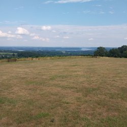
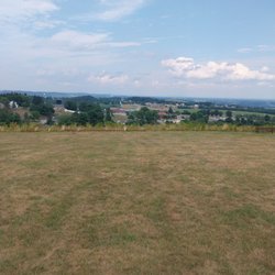


Chestnut Grove Natural Area - hiking - Updated June 2026
Best of Conestoga
People found Chestnut Grove Natural Area by searching for…
Watch Sunset in Conestoga, Pennsylvania
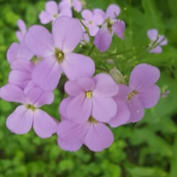
Flower Fields in Conestoga, Pennsylvania
Sunset View in Conestoga, Pennsylvania
River Swimming in Conestoga, Pennsylvania
Scenic Overlook in Conestoga, Pennsylvania
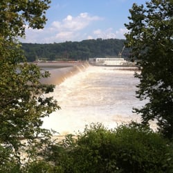
Hiking Trails With Waterfalls in Conestoga, Pennsylvania
Sunrise View in Conestoga, Pennsylvania
Things to Do in Conestoga, Pennsylvania
Beautiful Views in Conestoga, Pennsylvania
Scenic Views in Conestoga, Pennsylvania
Volleyball Courts in Conestoga, Pennsylvania
Secluded Spots in Conestoga, Pennsylvania
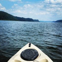
Fishing Spots in Conestoga, Pennsylvania
Places to Take Pictures in Conestoga, Pennsylvania
State Parks Camping in Conestoga, Pennsylvania
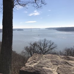
Lookout Points in Conestoga, Pennsylvania
Dog Swimming in Conestoga, Pennsylvania
Swimming Holes in Conestoga, Pennsylvania
Splash Pad in Conestoga, Pennsylvania
Lakes & Ponds in Conestoga, Pennsylvania
Scenic Drive in Conestoga, Pennsylvania
Easy Hikes in Conestoga, Pennsylvania
Trending Searches in Conestoga, PA
Browse Articles
Browse Nearby
Browse Brands
Related Searches in Conestoga, PA
Best Lookout Points to Visit in Conestoga, Pennsylvania
Best Off Leash Dog Parks in Conestoga, Pennsylvania
Best Parks for Parties and Events in Conestoga, Pennsylvania
Best Places for Horseback Riding in Conestoga, Pennsylvania
Best Spots for Star Gazing in Conestoga, Pennsylvania
Best Water Parks for Kids in Conestoga, Pennsylvania
Best Waterfalls and Swimming Holes in Conestoga, Pennsylvania
Check Out Great Playgrounds in Conestoga, Pennsylvania
Check Out Off Road Trails in Conestoga, Pennsylvania
Discover Baseball Fields Around Conestoga, Pennsylvania
Discover Dog Friendly Beaches Near Conestoga, Pennsylvania
Discover Dog Friendly Trails to Explore in Conestoga, Pennsylvania
Discover Fun Toddler Parks in Conestoga, Pennsylvania for Your Little One
Discover Lakes & Ponds to Explore in Conestoga, Pennsylvania
Discover Popular Bike Trails in Conestoga, Pennsylvania
Discover Popular Photo Spots in Conestoga, Pennsylvania
Discover Scenic Mountain Bike Trails Near Conestoga, Pennsylvania
Discover Top Nature Parks to Visit in Conestoga, Pennsylvania
Discover a Hiking Trail in Conestoga, Pennsylvania
Discover the Best Beaches in Conestoga, Pennsylvania
Discover the Best Night Hike Trails in Conestoga, Pennsylvania
Dog-Friendly Hikes With Dogs in Conestoga, Pennsylvania
Effective Stairs Workout Spots in Conestoga, Pennsylvania
Enjoy Camping Adventures Around Conestoga, Pennsylvania
Enjoy River Tubing Adventures in Conestoga, Pennsylvania
Enjoy Scenic Night View Experiences in Conestoga, Pennsylvania
Enjoy Tent Camping Spots Around Conestoga, Pennsylvania
Enjoy the Best Picnic Spots and Ideas in Conestoga, Pennsylvania
Enjoy the Best Walking Trails in Conestoga, Pennsylvania
Exciting Cliff Jumping Spots in Conestoga, Pennsylvania
Explore Beautiful Parks and Green Spaces in Conestoga, Pennsylvania
Explore Easy Hikes Perfect for All in Conestoga, Pennsylvania
Explore Family-Friendly Zoos and Wildlife in Conestoga, Pennsylvania
Explore Free Picnic Areas Around Conestoga, Pennsylvania
Explore Free Things to Do Around Conestoga, Pennsylvania
Explore Landmarks & Historical Buildings in Conestoga, Pennsylvania
Explore Parks With Pull Up Bars in Conestoga, Pennsylvania
Explore Popular Campgrounds Near Conestoga, Pennsylvania
Explore Popular Picnic Areas Around Conestoga, Pennsylvania
Explore Popular RV Parks Around Conestoga, Pennsylvania
Explore Popular Scenic Overlook Points in Conestoga, Pennsylvania
Explore Popular Scenic Views Near Conestoga, Pennsylvania
Explore Popular View Points Around Conestoga, Pennsylvania
Explore Scenic Lakes to Visit in Conestoga, Pennsylvania
Explore Secret Spots Worth Visiting in Conestoga, Pennsylvania
Explore Summer Camps for All Ages in Conestoga, Pennsylvania
Explore Top Dog Parks in Conestoga, Pennsylvania Near You
Explore Top Gyms in Conestoga, Pennsylvania Now
Explore the Best Swimming Holes Around Conestoga, Pennsylvania
People who viewed Chestnut Grove Natural Area also viewed
Tucquan Glen Nature Preserve
8 reviews
Samuel S. Lewis State Park
7 reviews
Heritage Rail Trail
15 reviews
The Serpentine Barrens
2 reviews
Rocky Ridge County Park
6 reviews
Northwest Lancaster County River Trail
8 reviews
Pinnacle Overlook
5 reviews
PPL Holtwood Environmental Preserve
2 reviews
Stonewood Park
2 reviews
Richard M Nixon County Park
13 reviews