Coal Creek Trail Photos


You might also consider
More like Coal Creek Trail
Recommended Reviews - Coal Creek Trail
Start your review...

Reviews With Photos

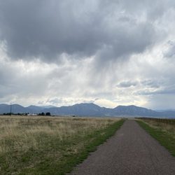
The Coal Creek Trail is a mainly a dirt/ pea gravel trail that runs through the towns of Louisville, Lafayette and Superior. A few years ago a major flood in the area wiped out this trail, Im glad to see that its been repaired. This trail connects up to the new US36 bikeway in Superior next to Grasso park and is down the street from Whole Foods, which makes it an easy place to stop and have a wholesome snack. The difficulty level for the trail would be about a 2.5 out of 5. ( mostly flat with a few steep inclines) This trail runs through wooded areas, open flat prairie land, neighborhoods( but is clearly marked) and a golf course with signs posted along the trail that read " watch for flying golf balls! " Biking the entire trail takes about 2 to 3 hours (depending on your skill level and weather/trail conditions)

2 years ago
This trail is very short and unkempt. It does go along some soccer fields and other playgrounds. Frankly, it was sketchy with evidence of homeless people. Don't get me wrong! I think the homeless deserve a place to rest, but let's protect our children in a park! read more


Beautiful and lengthy trail along the creek. Connects with the Rock Creek Trail and others along the way. In Lafayette, it has a good gradual elevation with a few hills to mix things up. Great place to bike and walk, with a lot of neighborhood access as well. read more


One of our favorite trails to ride bikes, though you can also walk or jog. Wide, well groomed paths or some concrete. There is also a single track for more adventurous mountain bikers. Not only are the views beautiful any time of year, but for this over 50, novice mountain biker the mostly flat with some rolling "hills" is a perfect workout, with some challenge. My family of 3, including a teen boy who loved riding the single track, we rode 11 miles. For me too much not having rode in a long time, but will definietly return. Easy, wide for me, and husband and son can do the single track or ride ahead when I am too slow. Lol. Coming from Firestone, there are many areas to park and enter trail along the way, so routes are numerous for those of us easily bored doing the same thing over and over. Oh...final thought. Yes you can walk your dog, and poop bags all along the way, but sad to see so many don't bother to actually use them read more


10 years ago
The Coal Creek Trail is a mainly a dirt/ pea gravel trail that runs through the towns of Louisville, Lafayette and Superior. A few years ago a major flood in the area wiped out this trail, Im glad to see that its been repaired. This trail connects up to the new US36 bikeway in Superior next to Grasso park and is down the street from Whole Foods, which makes it an easy place to stop and have a wholesome snack. The difficulty level for the trail would be about a 2.5 out of 5. ( mostly flat with a few steep inclines) This trail runs through wooded areas, open flat prairie land, neighborhoods( but is clearly marked) and a golf course with signs posted along the trail that read " watch for flying golf balls! " Biking the entire trail takes about 2 to 3 hours (depending on your skill level and weather/trail conditions) read more


7 years ago
I walk this trail 3-4 times per week. Concrete paths, horse trails in grass, mountain bike paths. Great views, especially in the late afternoon as the sun is setting over the Rockies! read more


More info about Coal Creek Trail
Lafayette, CO 80026
Directions
Hours
Outdoor Amenities


Coal Creek Trail - hiking - Updated June 2026
Best of Lafayette
People found Coal Creek Trail by searching for…
Hiking Trails With Waterfalls in Lafayette, CO
Walking Trails in Lafayette, CO
Running Trails in Lafayette, CO
Parks for Kids in Lafayette, CO
Mountain Bike Trails in Lafayette, CO
Off Leash Dog Hikes in Lafayette, CO
Beautiful Views in Lafayette, CO
Hiking With Kids in Lafayette, CO
Scenic Overlook in Lafayette, CO
Hiking Trails Kid Friendly in Lafayette, CO
Dog Friendly Trails in Lafayette, CO
Scenic Restaurants in Lafayette, CO
Fun Things to Do With Kids in Lafayette, CO
Playgrounds for Kids in Lafayette, CO
Trending Searches in Lafayette, CO
Amusement Parks near Coal Creek Trail
Black Owned Nail Salons near Coal Creek Trail
Boat Rental near Coal Creek Trail
Cliff Jumping near Coal Creek Trail
Dog Friendly Trails near Coal Creek Trail
Fishing Spots near Coal Creek Trail
Free Kids Activities near Coal Creek Trail
Jet Ski Rental near Coal Creek Trail
Outdoor Activities near Coal Creek Trail
Pick Your Own Farms near Coal Creek Trail
Public Shower near Coal Creek Trail
Rock Quarry near Coal Creek Trail
Running Trails near Coal Creek Trail
Scenic Drive near Coal Creek Trail
Secluded Spots near Coal Creek Trail
Soccer Store near Coal Creek Trail
Splash Pad near Coal Creek Trail
Strawberry Picking near Coal Creek Trail
Sunrise View near Coal Creek Trail
Swimming Holes near Coal Creek Trail
Swimming Lakes near Coal Creek Trail
Swimming Pools near Coal Creek Trail
Watch Sunset near Coal Creek Trail
Browse Articles
Browse Nearby
BEST of Lafayette, Colorado Coffee near Coal Creek Trail
BEST of Lafayette, Colorado Restaurants near Coal Creek Trail
BEST of Lafayette, Colorado Things to Do near Coal Creek Trail
BEST of Lafayette, Colorado Breakfast near Coal Creek Trail
BEST of Lafayette, Colorado Parks near Coal Creek Trail
BEST of Lafayette, Colorado Playgrounds near Coal Creek Trail
BEST of Lafayette, Colorado Hot Springs near Coal Creek Trail
Browse Brands
Related Searches in Lafayette, CO
Affordable Kayak Rental Services in Lafayette, Colorado
Best Fishing Locations and Guides in Lafayette, Colorado
Best Nature Trails for Hiking in Lafayette, Colorado
Best Places for Horseback Riding in Lafayette, Colorado
Check Out Off Road Trails in Lafayette, Colorado
Discover Dog Friendly Trails to Explore in Lafayette, Colorado
Discover Kid Friendly Hiking Trails in Lafayette, Colorado
Discover Scenic Bike Paths in Lafayette, Colorado
Discover Scenic Mountain Bike Trails Near Lafayette, Colorado
Discover Scenic Waterfall Spots in Lafayette, Colorado
Discover the Best Night Hike Trails in Lafayette, Colorado
Dog-Friendly Hikes With Dogs in Lafayette, Colorado
Enjoy Camping Adventures Around Lafayette, Colorado
Enjoy Exciting Mountain Biking Adventures in Lafayette, Colorado
Enjoy Kayaking Adventures in Lafayette, Colorado
Enjoy Tent Camping Spots Around Lafayette, Colorado
Enjoy Water Activities and Fun in Lafayette, Colorado
Enjoy a Beautiful Waterfall Hike in Lafayette, Colorado
Enjoy the Best Picnic Spots and Ideas in Lafayette, Colorado
Enjoy the Best Walking Path in Lafayette, Colorado
Enjoy the Best Walking Trails in Lafayette, Colorado
Exciting Cliff Jumping Spots in Lafayette, Colorado
Experience Thrilling White Water Rafting in Lafayette, Colorado
Explore Beautiful Parks and Green Spaces in Lafayette, Colorado
Explore Easy Hikes Perfect for All in Lafayette, Colorado
Explore Fun Activities to Do in Lafayette, Colorado
Explore Popular Campgrounds Near Lafayette, Colorado
Explore Scenic Lakes to Visit in Lafayette, Colorado
Explore the Best Beach Spots in Lafayette, Colorado
Explore the Best Boating Spots in Lafayette, Colorado
Explore the Best Swimming Holes Around Lafayette, Colorado
Explore the Best Trail Options in Lafayette, Colorado
Family Friendly Hiking With Kids in Lafayette, Colorado
Find Beautiful Views in Lafayette, Colorado
Find Popular Ziplining Spots Around Lafayette, Colorado
Find the Best Scenic View Locations in Lafayette, Colorado
Great Places to Walk in Lafayette, Colorado
Hiking Trails With Waterfalls in Lafayette, Colorado
Off Leash Dog Hiking Trails in Lafayette, Colorado
Plan a Scenic Drive Route Near Lafayette, Colorado
Popular Outdoor Activities to Try in Lafayette, Colorado
Popular Picnic Spots to Visit in Lafayette, Colorado
Safe River Swimming Areas in Lafayette, Colorado
Safe and Fun Parks for Kids in Lafayette, Colorado
Top Climbing Spots and Gyms in Lafayette, Colorado
Top Running Trails to Explore in Lafayette, Colorado
Top Swimming Lakes to Enjoy in Lafayette, Colorado
Top Swimming Spots and Pools in Lafayette, Colorado