Devil's Punchbowl Natural Area Photos


You might also consider
More like Devil's Punchbowl Natural Area
Recommended Reviews - Devil's Punchbowl Natural Area
Start your review...

Reviews With Photos


This is a beautiful area, but make sure you are aware of a few things before starting your trip: 1. There is NO cell phone service. Make sure to have a planned meeting time and place as well as paper copies of the map for each member of your group in case you get separated. 2. There is NO shade and NO water. Be prepared and bring plenty of extra water and sunscreen! 3. These hikes are difficult. While the loop trail is "only" a 1 mile hike, there is a large elevation change and the loose gravel/sand on the path makes the terrain difficult. The bathrooms are, essentially, a nicer version of a port-a-potty. I cannot stress enough that there is no water, and that includes handwashing sinks! There was hand sanitizer available during our trip, but it wouldn't hurt to be prepared with your own. Make sure to stop and visit the resident animals, including a lovely bonded pair of ravens! These animals are at the wildlife center directly off the parking lot. You can also find maps and staff members at this center.

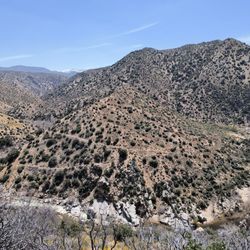
One of my favorite hikes for over 20 years, located on the San Andreas fault line, never disappoints. The trail has challenging climbs, beautiful flora (especially in spring April/May) and panoramic views of the Mojave desert. The Bob cat fire destroyed an abundance of pine trees, which diminished the amount of shade about 90% along the trail, so bring plenty of water and stay hydrated. This time the trail was like an obstacle course in certain areas after the high winds downed an abundance of burnt, dead trees. Round trip approx 8 miles. Pack in pack out.


This is a review of the Devil's Chair Trail which was ~6.9 miles and took ~3.5 hours to complete. There are still some charred remains from the 2020 Bobcat Fire. Ton of inclines / declines so expect a good workout. Trail was narrow for the most part so watch your steps. In addition, the trail was mostly exposed to the sun so make preparations in advance. Short video of the hike: https://www.youtube.com/watch?v=QGE1YfEkF0U

Seems like there was a trend a while back to name odd natural formations after the Lord of the Underworld himself, which is a bit scary and shortsighted when you think about it. Devil's Punchbowl, Devil's Postpile, Devil's Chair....one could go one and on. I prefer to think of this area as Titan's Punchbowl; one could easily imagine a Titan dipping a ladle into this rock-lined basin for a sip of grog. But whatever you want to call it, come for a visit. This Natural Area is stunning, has free parking and admission, and has outdoor activities for all levels. There are several trails, ranging from the Pinon Nature Trail (1/3 of a mile round trip), the Loop Trail (a very strenuous 1 mile round trip into and out the punchbowl), and the Devil's Chair Trail (around 8 miles round trip.) I'd say the best time to visit is fall or spring to avoid weather extremes. Bring water and sunscreen. And, of course, bring your camera. There's a tiny interpretive center that is usually staffed with a ranger or volunteer to answer questions. The trails were in great shape but are not for the easily intimidated. Wear hiking boots (you will need that tread) and bring a hiking stick if you'd like assistance with your balance; the Loop Trail was pretty steep at times. The trails are well-marked. Always call first to ensure road and weather conditions. Thank you LA County for doing something right and preserving this stunning landscape.

Beautiful area! I enjoy the Devil's Chair Trail (be sure to take a snack and LOTS of water). The views at almost any point are beautiful. I wish the restroom facilities were better, but the new facilities are a big improvement over the old portapotties. For the restrooms: adding hand sanitizer stations would be a big help. Overall, the park is recovering nicely from the 2020 Bobcat Fire, and the trails are still amazing.

An absolute gem if you live in the Antelope Valley. It's a 40 minute drive from where I live in Palmdale, and totally worth it. From all the recent rain and melting snow there are a lot of creeks. The views are spectacular right now. I did the devils chair hike which is roughly 7 miles out and back. Not too strenuous, but also not for complete beginners. When you get to the devils chair, there's a cool outlook you can walk to and see some views of the area. The park is closed on Monday and the visitor center burnt down in a fire so they don't have the owls or rattlesnakes anymore. There is a mile loop you can also do and a few other trails, one of which is over 20 miles. Please remember to pack up all your trash and leave the area how you found it.


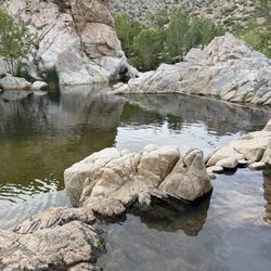
California and all their hidden gems. Another amazing place that's out and away from all the hustle and bustle of the city. Clearly a first for me. Just a little over an hour from LA, you're transplanted into a little realm of nature. You wouldn't have thought this was out here. The crazy thing is, I've driven on the main stretch road plenty of times to and from vegas. And not even know that this place even existed. Getting there it's off the 14 fwy and Pearblossom Rd. Going through pass LittleRock. From there it seems like your just driving on. Then your enter the park. Upon entering, we were greeted with a staff member telling us about the mask safety. There's parking lot inside but also parking can be used on the side of the main road entrance. Porter potties are available at the entrance. There was good amount of people already there. The ranger station was closed but staff members were on hand with any questions. We spoke with Victoria who was such a sweetheart and very helpful. She guided us through the map about the different trails. Mentioned the main one that everyone does, Loop Trail which was perfect for us as it was our first time. Also, told us that how your able to bring food if you wanted to have a snack along the water. But just pick up after yourself. Very friendly and energetic. Before even the hike, we just stood there at the top just in awe of how beautiful this place is. It's amazing how it's like in the middle of nowhere and then this oasis appears. We did the the loop trail which i believe is maybe a mile to 2 the most. Don't quote me on that. The path leading you down was nice. It might be a little slippery as it wasn't much of gravel or hard dirt. Started off with soft sand path. Heading down you could already hear the creek. The view is spectacular. You could do the whole hike pretty fast but it tends to take people as well as myself longer as we like to take in all the scenery. Every bend and turn is a Kodak moment. Once down to the creek, which was a little busy with people. Find yourself a spot, take your shoes off and have a seat with you toes in the water. Just pure bliss. Have a little picnic if you brought something. Just sitting there and listening to the water flowing and nature was just pure bliss. Back to the hike, we encountered and sat and watch a couple of rock climber taking park in a climb. The rock formations reminded me of half dome in Yosemite. Just watching them was very eerie as your like please don't fall. The path starts by leading you down to the creek and then back up to the top. It ends and takes you straight back to the parking lot. There's also a longer hike that's about 6,7 miles roundtrip. That'll be for the next visit. Overall experience, absolutely love this hike. The scenery alone is one in a million. It does get busy so be prepared for that. Mask are required but your able to take off when no one is around you. Just practice common sense. Highly recommend being a pack lunch and enjoying it by the creek.

3.5 stars for the overall hike to Devils chair. Upon finishing, dehydrated after hiking in 90+ degree weather, I could not find one working water fountain around the parking lot and the office was closed (middle of the week middle of the day). I definitely felt defeated. Id give the scenery 4 stars for having, at times, pretty remarkable views... The hike itself didn't seem strenuous at, as it is probably manageable for even the more beginner hikers. BUT, with the heat, the really minimal shade, some parts of the trail that is just completely exposed to the elements... it seemed pretty challenging. There's no water at the devils chair and no water anywhere along the trail so bring more than enough or you WILL regret it. Would I do it again? Probably not...Do I regret it? Not really, maybe just the season or time that I came. I think you can get a lot out of the scenery without making it to the "chair" in my opinion. Hints: Do the 1-mile loop first if you want to explore the actual Punchbowl. Well worth it. Hike early morning to make it back before 1-2pm. Bring extra water as their could be none on the whole trek. Bring lots of sunscreen. There's a soda machine outside the picnic area for refreshments. Hopefully you have at least $1.50.

Very clean and well-maintained park with easy beginner level hiking, also dog-friendly! The elevation gain is only about 1000 feet so you don't even need hiking poles. Wintertime is the best time to hike deserts you get the nice weather and beautiful views with half the sweating. Wear layers as it's cool in the morning but then heats up where you can comfortably hike in just a t-shirt. Even though it states it's about a round trip of 7-8 miles to Devil's Chair from the Natural Area, the distance felt shorter as the path is so level you don't feel exhausted at the end. This hike to Devil's Chair is not a loop but there is a one-mile loop hike perfect for children that goes around the Devil's Punchbowl. The Devil's Chair path is quite narrow in some areas, but is mostly fine dirt and not gravel so easy to hike. At the end of the hike by Devil's Chair, the path does get quite narrow with cliffs on either side so be wary if you have a fear of heights. There is metal railing and fences put up for safety but in some sections due to erosion has been knocked down. Really wonderful almost 360-degree view of the Pearblossom area from the Devil's Chair. Free parking and entrance to this natural area so take advantage, not many parks are completely free. The information center is different with live snakes, gecko, tarantula and honeypot ants on display. Near the information center, there are many picnic tables for larger groups to gather. The bathrooms are kept clean but they are your standard state-park non-flushing outhouse setups (bring hand sanitizer).

2 months ago
It is so beautiful and amazing. The view is surreal. When you go into the nature center and visit the snakes and beetles it's cool but then you walk out to an observatory type deck and it's breathtaking! read more


6 months ago
This review is for the Devil's Chair Trail: Went with two friends and we finished in around 3 hours. The start is the hardest part since there's little to no shade, and there are still burnt trees along the trail. We also ran into a fallen tree on the trail and had to climb over it. I took some photos and one video from our hike. Once we got to the Devil's Chair, the views were nice, just not the most impressive compared to other hikes. Worth doing once, but I wouldn't go out of my way to repeat it which is why I give it 4/5 stars. read more


 - Hiking Near Me - Pearblossom, California")


9 months ago
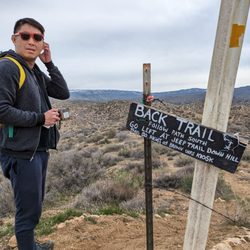
I've been hiking in this area for a few years. I started out with the short loop trail then advanced to the Devil's Punchbowl trail, and then yesterday completed the Devil's Chair trail. I didn't know about the Chair trail until recently. I found that with the short loop trail, since it was reasonably close to the ranger station, the reception was okay. While hiking the Devil's Punchbowl trail there was hardly any reception. I have Verizon as my carrier. The Devil's Chair Trail had great reception. I was able to periodically text my family and update them, letting them know I was okay. When hiking I use Spotify and ensure my songs are downloaded so even offline I can listen to music. This also works well when I want to listen to Audiobooks I've downloaded. The Chair trail was quiet, there wasn't anyone else on the trail or even much wildlife besides lizards and some insects. It wasn't bad at all. The trail was pretty well maintained with some areas needing extra support. Shout-out to the employees who ensured the steep cliffs and the Devil's Chair Trail were safe to walk on. The Chair itself is on a rock so someone had to get there and install the fencing for safety. Thank you, whoever you are! As with many other trails in Southern California there is some fire damage. Some fallen trees. This trail has A LOT of rocks so step gingerly and don't roll your ankles. Most of the trail is not covered so sunscreen/sunblock and proper gear is really important. The trail is roughly 3-5 hours. I clocked about 3 hours 55 minutes moving time on Strava but 4 hours 28 minutes total on AllTrails. I stopped a bit to catch my breath, get water and just observe nature. Everyone says it's a 7 mile trail. I'm not sure what I did but it was 9 miles for me. I am blessed to have been able to enjoy it. read more


2 years ago
This is a beautiful area, but make sure you are aware of a few things before starting your trip: 1. There is NO cell phone service. Make sure to have a planned meeting time and place as well as paper copies of the map for each member of your group in case you get separated. 2. There is NO shade and NO water. Be prepared and bring plenty of extra water and sunscreen! 3. These hikes are difficult. While the loop trail is "only" a 1 mile hike, there is a large elevation change and the loose gravel/sand on the path makes the terrain difficult. The bathrooms are, essentially, a nicer version of a port-a-potty. I cannot stress enough that there is no water, and that includes handwashing sinks! There was hand sanitizer available during our trip, but it wouldn't hurt to be prepared with your own. Make sure to stop and visit the resident animals, including a lovely bonded pair of ravens! These animals are at the wildlife center directly off the parking lot. You can also find maps and staff members at this center. read more


1 year ago
One of my favorite hikes for over 20 years, located on the San Andreas fault line, never disappoints. The trail has challenging climbs, beautiful flora (especially in spring April/May) and panoramic views of the Mojave desert. The Bob cat fire destroyed an abundance of pine trees, which diminished the amount of shade about 90% along the trail, so bring plenty of water and stay hydrated. This time the trail was like an obstacle course in certain areas after the high winds downed an abundance of burnt, dead trees. Round trip approx 8 miles. Pack in pack out. read more


3 years ago
This was a great detour off Pearblossom hwy on our way to Vegas. Great views for a short walk and a hike. read more


2 years ago
This is a review of the Devil's Chair Trail which was ~6.9 miles and took ~3.5 hours to complete. There are still some charred remains from the 2020 Bobcat Fire. Ton of inclines / declines so expect a good workout. Trail was narrow for the most part so watch your steps. In addition, the trail was mostly exposed to the sun so make preparations in advance. Short video of the hike: https://www.youtube.com/watch?v=QGE1YfEkF0U read more


Seems like there was a trend a while back to name odd natural formations after the Lord of the Underworld himself, which is a bit scary and shortsighted when you think about it. Devil's Punchbowl, Devil's Postpile, Devil's Chair....one could go one and on. I prefer to think of this area as Titan's Punchbowl; one could easily imagine a Titan dipping a ladle into this rock-lined basin for a sip of grog. But whatever you want to call it, come for a visit. This Natural Area is stunning, has free parking and admission, and has outdoor activities for all levels. There are several trails, ranging from the Pinon Nature Trail (1/3 of a mile round trip), the Loop Trail (a very strenuous 1 mile round trip into and out the punchbowl), and the Devil's Chair Trail (around 8 miles round trip.) I'd say the best time to visit is fall or spring to avoid weather extremes. Bring water and sunscreen. And, of course, bring your camera. There's a tiny interpretive center that is usually staffed with a ranger or volunteer to answer questions. The trails were in great shape but are not for the easily intimidated. Wear hiking boots (you will need that tread) and bring a hiking stick if you'd like assistance with your balance; the Loop Trail was pretty steep at times. The trails are well-marked. Always call first to ensure road and weather conditions. Thank you LA County for doing something right and preserving this stunning landscape. read more


Beautiful area! I enjoy the Devil's Chair Trail (be sure to take a snack and LOTS of water). The views at almost any point are beautiful. I wish the restroom facilities were better, but the new facilities are a big improvement over the old portapotties. For the restrooms: adding hand sanitizer stations would be a big help. Overall, the park is recovering nicely from the 2020 Bobcat Fire, and the trails are still amazing. read more

3 years ago
An absolute gem if you live in the Antelope Valley. It's a 40 minute drive from where I live in Palmdale, and totally worth it. From all the recent rain and melting snow there are a lot of creeks. The views are spectacular right now. I did the devils chair hike which is roughly 7 miles out and back. Not too strenuous, but also not for complete beginners. When you get to the devils chair, there's a cool outlook you can walk to and see some views of the area. The park is closed on Monday and the visitor center burnt down in a fire so they don't have the owls or rattlesnakes anymore. There is a mile loop you can also do and a few other trails, one of which is over 20 miles. Please remember to pack up all your trash and leave the area how you found it. read more


4 years ago
Still a beautiful place and one of my favorite places in Southern California. Hopefully they will open come April of this year. read more


California and all their hidden gems. Another amazing place that's out and away from all the hustle and bustle of the city. Clearly a first for me. Just a little over an hour from LA, you're transplanted into a little realm of nature. You wouldn't have thought this was out here. The crazy thing is, I've driven on the main stretch road plenty of times to and from vegas. And not even know that this place even existed. Getting there it's off the 14 fwy and Pearblossom Rd. Going through pass LittleRock. From there it seems like your just driving on. Then your enter the park. Upon entering, we were greeted with a staff member telling us about the mask safety. There's parking lot inside but also parking can be used on the side of the main road entrance. Porter potties are available at the entrance. There was good amount of people already there. The ranger station was closed but staff members were on hand with any questions. We spoke with Victoria who was such a sweetheart and very helpful. She guided us through the map about the different trails. Mentioned the main one that everyone does, Loop Trail which was perfect for us as it was our first time. Also, told us that how your able to bring food if you wanted to have a snack along the water. But just pick up after yourself. Very friendly and energetic. Before even the hike, we just stood there at the top just in awe of how beautiful this place is. It's amazing how it's like in the middle of nowhere and then this oasis appears. We did the the loop trail which i believe is maybe a mile to 2 the most. Don't quote me on that. The path leading you down was nice. It might be a little slippery as it wasn't much of gravel or hard dirt. Started off with soft sand path. Heading down you could already hear the creek. The view is spectacular. You could do the whole hike pretty fast but it tends to take people as well as myself longer as we like to take in all the scenery. Every bend and turn is a Kodak moment. Once down to the creek, which was a little busy with people. Find yourself a spot, take your shoes off and have a seat with you toes in the water. Just pure bliss. Have a little picnic if you brought something. Just sitting there and listening to the water flowing and nature was just pure bliss. Back to the hike, we encountered and sat and watch a couple of rock climber taking park in a climb. The rock formations reminded me of half dome in Yosemite. Just watching them was very eerie as your like please don't fall. The path starts by leading you down to the creek and then back up to the top. It ends and takes you straight back to the parking lot. There's also a longer hike that's about 6,7 miles roundtrip. That'll be for the next visit. Overall experience, absolutely love this hike. The scenery alone is one in a million. It does get busy so be prepared for that. Mask are required but your able to take off when no one is around you. Just practice common sense. Highly recommend being a pack lunch and enjoying it by the creek. read more


8 years ago
3.5 stars for the overall hike to Devils chair. Upon finishing, dehydrated after hiking in 90+ degree weather, I could not find one working water fountain around the parking lot and the office was closed (middle of the week middle of the day). I definitely felt defeated. Id give the scenery 4 stars for having, at times, pretty remarkable views... The hike itself didn't seem strenuous at, as it is probably manageable for even the more beginner hikers. BUT, with the heat, the really minimal shade, some parts of the trail that is just completely exposed to the elements... it seemed pretty challenging. There's no water at the devils chair and no water anywhere along the trail so bring more than enough or you WILL regret it. Would I do it again? Probably not...Do I regret it? Not really, maybe just the season or time that I came. I think you can get a lot out of the scenery without making it to the "chair" in my opinion. Hints: Do the 1-mile loop first if you want to explore the actual Punchbowl. Well worth it. Hike early morning to make it back before 1-2pm. Bring extra water as their could be none on the whole trek. Bring lots of sunscreen. There's a soda machine outside the picnic area for refreshments. Hopefully you have at least $1.50. read more


Very clean and well-maintained park with easy beginner level hiking, also dog-friendly! The elevation gain is only about 1000 feet so you don't even need hiking poles. Wintertime is the best time to hike deserts you get the nice weather and beautiful views with half the sweating. Wear layers as it's cool in the morning but then heats up where you can comfortably hike in just a t-shirt. Even though it states it's about a round trip of 7-8 miles to Devil's Chair from the Natural Area, the distance felt shorter as the path is so level you don't feel exhausted at the end. This hike to Devil's Chair is not a loop but there is a one-mile loop hike perfect for children that goes around the Devil's Punchbowl. The Devil's Chair path is quite narrow in some areas, but is mostly fine dirt and not gravel so easy to hike. At the end of the hike by Devil's Chair, the path does get quite narrow with cliffs on either side so be wary if you have a fear of heights. There is metal railing and fences put up for safety but in some sections due to erosion has been knocked down. Really wonderful almost 360-degree view of the Pearblossom area from the Devil's Chair. Free parking and entrance to this natural area so take advantage, not many parks are completely free. The information center is different with live snakes, gecko, tarantula and honeypot ants on display. Near the information center, there are many picnic tables for larger groups to gather. The bathrooms are kept clean but they are your standard state-park non-flushing outhouse setups (bring hand sanitizer). read more


4 years ago
I was here today, Wednesday, August 17th. I arrived around 730am. There were only 2 cars in the parking lot (free parking). There's restrooms near the trailhead and they're clean. We started our hike at 8am and got back to the parking lot at 1030am. It took us 3.5hrs to complete. My Garmin logged in a total of 7.59 miles. We got to see the punchbowl and the rock formations. It was pretty hot. Triple digits hot. There's a bit of shade but it's mostly exposed. There's some incline at the beginning of the trail and on the way back from the "Devil's Chair". The trail is well marked and easy to follow but it's still recovering from the 2020 Bobcat Fire. You can see the aftermath from the fire. Overall, it was a great hike! Happy Hiking! read more


3 years ago
4 years ago
2 years ago
11 years ago
There is one good thing about living near a massive fault line -- enjoying the unique scenery it creates. I've done several hikes along the San Andreas Fault (I realize this doesn't sound very bright), and Devil's Punchbowl Natural Area is one of the best areas I've found. Getting there takes a little bit of effort, and can be confusing, so I would recommend using your GPS. There is a parking lot at the entrance, with plenty of overflow parking along the road. There is no fee for parking, and no special permit needed for hiking. We did the Devil's Chair trail, followed by the loop trail. These two combined ended up being about 8.5 miles. The stats on "elevation gain" won't tell you much about the difficulty level of the hike, as it is one of those that rolls up and down throughout the hike. I would call it moderate, but if you were there on a really hot day, it could feel a lot more difficult. After you've hiked to the chair and back, the one-mile loop near the visitors center is definitely worth the extra mile, but don't go into it thinking it is going to be flat like we did... The trails are well signed and easy to follow, but if you are concerned about directions, they have maps printed-off at the visitors center. The trailhead for most of the hikes, other than the loop trail, is in the picnic area above the parking lot. The scenery is beautiful, and worth the drive. You get a little bit of everything hiking in Southern California has to offer: desert vistas, interesting rock formations, pine trees, and snow-capped peaks in the background. While this isn't the most spectacular hike I have done in Southern California, it is something unusual, and a nice change of pace. read more


Please let it involve liquor. Please let it involve liquor. Please let it involve liquor. It doesn't involve liquor. The punchbowl is a large rocky bowl that I'd more likely call Devil's Dishrack because the gigantic outcropping of stone looks almost like a set of broken dishes. This park, still within the confines of Los Angeles county, is in a quiet area north of recently re-opened Highway 2 and the San Gabriel Mountains. From the parking lot, it's a short walk to the rim of the bowl and there are three hiking trails: third of a mile, one-mile loop, and a 7.5-mile roundtrip trail. The one-mile loop gives you a good vantage point to take photos and it's short enough that you'll still have time for non-hiking activities later. Please let it involve liquor. read more


One of my friends recently did this hike and told me is worth to go.. Its far drive about 75 miles and almost 2 hrs.. Driving on thru curvy road on 2 Hwy Angeles Forest Fwy. Its nice view driving thru but do watch out for bikers. We got there around 11 ish, just hoping it wont be too hot to hike..But surprised, that is cool. Parking a lot is small but lucky we got spot. Bathroom - 1 for Men & 1 for Women.. Pit bathroom. There are also portable bathroom on parking a lot There are water fountain but there no water. Bring own water or water bottle. You could refill water in visitor center Started Pinon Pathway trail - Self Guided Nature Trail - 1/3 mile loop Pinon Pathway Trail continue to Punchbowl Loop Trail - Easy 2 miles Hike. We went off the trail and walk along water steam except is no water. Which is nicer view & cooler . If u don't you get lost, is very easy to back track back to trail. Its good place for beginner rock climber.. The hike was so short we decide to do Devil Chair is about 7.54 miles (in and out trail).. It's easy except last 1 miles. Its have more shade and interesting view of the rocks. I found couple rocks look like human head shape and doggy shape..The colors of the rock are beautiful. Great view at end of Devil Chair. It would be nicer view if there are water. I probably wont go back there unless there are water on stream read more


Awesome place! There is a friendly staff that welcomes you. They have a few life animals such as snakes, owls, ant colony and bee hive that people can observe. The trail is not flat, which keeps it interesting / but it's not "hard" - it's doable for beginners and kids. There are a few picnic tables under the shade for a pleasant picnic. One thing that I must say is.... The bathrooms are TERRIBLE!!! read more


9 years ago
Friday, Nov 10, 2017 was a no school day, we decided to take a family trip to Devil's Punchbowl for a half day outing, Personally, I will do whatever it takes to avoid amusement parks especially when we can experience nature. The drive from the Los Angeles area is approximately 75 miles each way, there is some stop and go traffic along the 5 freeway but once you cross over to Highway 14, speeds increase. The exit to Pearblossom is a nice drive up to the site area, the town has a nice rural feel. The nice thing about this Los Angeles County facility is that it is free to enter and enjoy. Parking is limited to about 30-40 cars, we only saw 6 parked vehicles when we arrived. There are restrooms but it may be best if you stop by the McDonald's on the way up. There is a small visitors center with live snakes and tarantulas behind glass along with a stuffed coyote and fox to view. They have two live owls outside in large cages for viewing, our favorite was the larger one named Squint, he actually hooted for us. The Devil's Punchbowl is a deep canyon caused by the earth's compression along the San Andreas fault, this is what keeps our state from staying flat (like Kansas) but also gives us earthquakes. The hiking trail is a loop, as long as you follow the trail markers and use common sense, it is a safe hike that you can take kids above the age of 7. Most of the trail is easy to moderate though you can lose your footing on steep declines, wearing hiking shoes is suggested over sneakers. The trails do not have hand rails and there are signs of erosion along the path, you need to be careful of these hazards and mind your children or anyone in your party that may slip and fall down hill. Once you reach the bottom of the canyon, the only way back to your car is uphill. I would say the level of difficulty on the way up is mild to moderate depending on your level of fitness and this is definitely a good way for you to get your daily cardio exercise. Try to avoid the hottest part of the day if you can, hiking this canyon after 3pm is much nicer than 12 noon. It took our family about 90 minutes to finish off the loop but we also stopped for photos, looked around, and be still for the peaceful silence. Due to the condition of these trails, we only rated this location a 4 out of 5 in Yelp but please don't let this discourage you from visiting this place. You will still have a nice experience with your visit here but just use common sense. Everyone in our group felt better after visiting this canyon. Tip #1: watch your speeds on the way back from the canyon to Highway 14, there is a slight decline to the road and it is easy to exceed the posted speed limit. Unfortunately, we saw many vehicles pulled over by the California Highway Patrol - this area is a speed trap! Use your cruise control by setting it near the speed limit if you can on the way back. A speeding ticket with fines and fees will easily be over $100 in CA not to mention the traffic school or the possible increase in your auto insurance policy. Tip #2: most of your kids will probably be hungry after the drive up and short hike, there is an In-n-Out Hamburger restaurant on the way back on Highway 14, you cannot miss it. read more


8 years ago
We came out here because of The Devil's Chair, about 7.5 mile roundtrip. You can also access The Devil's Chair from the South Fork Trail. There are some small hikes, but you're not going to drive this far just to do a 1 mile loop. Unless your an local in the area. There is a visitor center, picnic area, and restrooms all near the parking lot. Once you parked, the right side next to a porta potty is the start of Burkhart Trail which will connect to The Devil's Chair Trail. The trail is well marked, but just stay left all the way when you see a split. There are some shades in the area, but plan ahead if hiking during hot summer weather. This is a well maintained trail, I would rate it beginner to moderate. I didn't need my hiking poles, but you can use if needed. The view at The Devil's Chair was beautiful, it was worth the drive time. read more


7 years ago
The Devil's Punchbowl is an amazing place to go hiking. I have went with my dog on the loop trail. I have also went on a field trip here with the kids at my work. They have a ranger that will talk to the kids about the wildlife there. It is beautiful, and when we went today we got to see water and the bottom of the hill. It was great read more


8 years ago
This is definitely a place to spend most or part of the day. There are three hikes in the park and they are as follows: 1) Devil's Chair - 7-mile that I'd rate as beautiful and moderate intensity, 2) Devil's Punchbowl Loop - 1-mile with many spur trails where you could spend hours, & 3) Nature Loop - 1/3 of a mile that is easy for everyone. On the day I went, the Flannel Bush (Fremontia) were in full bloom displaying their bright yellow flowers. Although the hikes are partially shaded, the surrounding area is hot. I recommend getting there early or on a cool day......unless you like the heat. Enjoy! read more


 - supposedly blooms only 2-3 weeks each year. - Hiking Near Me - Pearblossom, California")


9 years ago
First visit and I was very impressed of how clean the area was when you first go in. There is a visiting area on the left and picnic area on your right. Picnic area has plenty of shade from the trees. Before you start your hike there is a list were you write your name and your guest names, time and comments. I'm assuming if anyone doesn't comeback they will go find you. As you walk there are numbers along the way but not enough signs on where to go. Some walking trails are hard to figure out on your way down. Be careful you might step on poo poo from the dogs but other than that it's pretty much clean. I will come back again in the spring time way too hot in the summer. One minus star for some of the confused trails. I highly recommend this place. Bring walking shoes and water! read more


9 years ago
My family and I went a few weeks ago. We did the 1 mile loop in early afternoon. There are 3 different trails to do. We just did the loop. Even though it's just 1 mile it was a little challenge because of the up and down terrain. The views are beautiful. We did go off the trail at the bottom to see the water in the little creek. HIGHLY recommend bringing/carrying water even though it's only a mile. If I were more experienced I would definitely try the " Devil's Chair" which is about 8 miles. I would say the views are worth the hike! Check it out! read more


7 years ago
I enjoyed this trail so much! It was very unique. We clocked approx 9 miles, doing the punchbowl and then to the Devil's chair. The punch bowl is a short easy hike from the parking lot. Heading to the chair is longer. It is a very narrow trail- don't expect to be side by side with your company. You'll be single file. Wear shoes with traction. You do not want to fall! It's a long angled slope beside you and you'll probably get hurt. Bring more than enough water because it does get really hot! We ended up giving water to someone not prepared whom was struggling. Yes, theres a decent amount of shade but where there isn't is pretty brutal. Dog friendly trail! Please look out for rattlesnakes though. There was also a sign for bears but I doubt that. Spray yourself with off spray or some sort of insect repellent. The bugs were horrible, today at least they were. I'd rate the trail as moderate. I mainly just remember it sucking for a little bit after leaving the trail. I felt like that was where most the incline hit us. Going back up. FYI there are portopotties and water fountain at beginning of hike/trailhead. read more


6 years ago
Hike was great! Got there just in time to be able to park in their parking lot. Loved the hike and was able to keep socially distant. Take enough water because it is very hot! Will definitely go back to try the other trails since I did the Devil's Chair this time. read more


10 years ago
I did the hike out to Devil's Chair, which my phone clocked in at just about 8 miles. It was forest-y from the start and you really feel like you are out of the city, especially since there was a dusting of snow on the ground! It's a moderate hike (a bit of elevation and switchbacks), but there are some sketchy areas if you're afraid of heights. While the trail is pretty narrow (it may have seemed more so with it covered in snow), there weren't a lot of people around in December so very manageable. There are some definite climate changes and it got VERY cold in areas so plan accordingly. Of course, bring water, snacks, hiking shoes and sunscreen too. be sure to visit the visitor center while you're out there. They were very friendly and had some wildlife (snakes and owls) to check out! read more


9 years ago
Devil's Chair Hike: Went 4/22/17. AllTrails app says it's 8.3 miles out and back so I'm going with that. There's a slight ascend at the beginning and end of the trail (on the way back) and the middle section has a variety of up/down - nothing too drastic. The beginning of the trail is rocky and it gets sandy right before you get to the "chair." There were a couple of spot with minor rock slide. This was my concern since I have a slight case of vertigo when the ground starts sliding but it wasn't too bad. The trail is mostly exposed so packed enough water and sunblock. The view on the hike was decent but I wasn't super "wowed" by the "Chair." read more


10 years ago
Hike Difficulty: Moderate Approx. Distance: 6 Miles roundtrip This review is specifically for the DEVILS CHAIR route. The punchbowl is nice but you really should do the devils chair hike. It's a good distance with plenty of easy gradual hills, and a lot of pretty sweeping views of the fault line rock formations along the way. The hills are also easy enough that a regular runner would enjoy this as a trail run. Make sure you go go on a cool day. There's not a ton of shade along the route and there's no shortcut back to the park entrance. 3 miles in, and 3 miles out (and felt even longer to me). The steeper hills are at the end - so if you get too hot, don't have water, etc. the trek back won't feel like much fun. I actually had decent cell service through probably 2/3's of the hike so at least if you pass out you have a 66% chance of calling for help :). Better odds than getting married...Am i right??? BA-DUM-TISH! It's an awesome hike and not buried too deep in the forest like a lot of the trails. I'd check this one out. read more


7 years ago
This was my first hike so I was kinda nervous about getting lost on the trail until I started noticing the mile markers...I followed it on my Apple Watch and it was pretty accurate..the distance to the Devils Chair is a bit over 3.7 miles (one way) Made it to the chair and the view was really nice..we stayed there for a few minutes to really take in the accomplishment of making it to the chair on our first hike..my advice, go with somebody that can hold a conversation with you like I did..when we got back down, it felt pretty good completing it on our first try..one last thing about this place, the cell phone reception is terrible..if you plan to meet up with someone, make sure u call them before getting there....learned that the hard way..but it was nice to be somewhere with no distractions.. read more

12 years ago
MINI-ME JOSHUA TREE!! BACKGROUND: Devil's Punchbowl, elevation 4,750 ft (1450 m), is a tilted sandstone formation in Los Angeles County. It is a county park within the Angeles National Forest on the northern slopes of the San Gabriel Mountains, near Littlerock, California. Short trails within the park showcase the geologic features along the Punchbowl and San Andreas Faults. There are connections to major longer trails leading to the high country. The Devil's Punchbowl Nature Center is operated by the Los Angeles County Department of Parks and Recreation. The center focuses on the flora, fauna, and geological features of the park, and the center offers school programs, parties, guided park tours, as well as telescope programs with an 11-inch telescope. STATS: Park Hours: Sunrise to Sunset Nature Center Hours: 9:00 am to 5:00 pm, Closed Mondays Vehicle Entrance Fee: N/A 7.5 miles out and back Elevation Gain: about 1,300-1,500 feet ESSENTIALS: At least 2 liters of water (depends on distance and temp) Know your limits Comfy hiking shoes with good lugs Layered Clothing High protein food/snacks Electrolytes Camera Hat (optional) Gloves to help grip rocks Rock climbing experience OUR ROUTE: I've been to the Devil's Punchbowl several times over the years and to me, it's like a mini Joshua Tree with one exception, there is a civilized trail available. The single track trail is mostly shaded by trees with minimal elevation gain and weaves hikers around the bowl to the Devil's Chair. The views along the trail are spectacular. The earth-toned rocks that jut out of the earth into their current form is breathtaking. At 3.1 miles, the trail turns south, descending a series of switchbacks and reaching a junction .3 miles later. Turning left, the trail goes up and down a bit and finally heads out over a narrow fin into the canyon. A metal protective railing on either side helps on some parts of the trail that are deteriorating. Once at the chair visitors have a 180 degree view that looks out into the 300′ deep canyon of tilted sandstone slabs as well as the valley floor to farmland through the mountain pass. Those adventurous types, there is a trail from the visitors center down to the rock pile where lots of rock hopping and rock climbing can be had. Use caution of direction as well as time. One time several hikers fell far behind and those of us who got out of the pile looked for them from high above. As time passed, we still could not see them and were about to call Search and Rescue. Thankfully, they filling responded to our calls and were able to get out the pile before dark. Trivia: The Australian band Wolfmother recorded their music video for the song "Mind's Eye" at the Devil's Punchbowl. Additionally, German heavy metal band Accept filmed a video for their song "Stampede" at the location. DISCLAIMER: Hiking is not something that can be taken lightly. It can be life-threatening as you see and hear on the news, people die or get lost all time. Please, if you are going to hike, never go alone and prepare for the worst, hope for the best. Remember when going for a hike, no matter how short you think it may be, always be prepared. Carry at least two liters of water for every five miles (more if the weather is warm), protein bar, nuts, and electrolytes. Wear sturdy lug sole shoes and protective clothing. Some areas the weather can change quicker than a fireman can put on his gear. It is also very important, always always always let a family member or friend know where you are going and when you expect to be back. Lastly, have fun when you hike it up. #HIKING #ROCKCLIMBING #ROCKSCRAMBLING #DEVILPUNCHBOWL #DEVILSCHAIR read more


 - Hiking Near Me - Pearblossom, California")


Page 1 of 4
More info about Devil's Punchbowl Natural Area
Ask the Community - Devil's Punchbowl Natural Area
Is this open rn during stage 2 of reopening in la county or is it still closed?
Closed because of the last fire.
Is this hike doable in the winter? What temperature is the water and do you have to cross it to complete the hike?
Yes it is, there is rarely snow at that elevation. The creeks to the chair are usually not that large or swift; you can use logs or rocks to cross but you may get your feet a… Read more
It's been snowing. Is the trail still open?
Of all the trails I've hiked in Angeles Forest, they receive the least amount of snow; there may be patches on the shady side of the mountain but def not requiring crampons.
I don't know the area at all. Do you drive up winding mountain roads, or is it a fairly easy drive?
Winding road on Hwy 2 all the way!
Review Highlights - Devil's Punchbowl Natural Area
You might also consider


Why does Yelp recommend reviews?
4 reviews that are not currently recommended
The reviews below are not factored into the business's overall star rating.
9 years ago
15 years ago
8 years ago
11 years ago
Devil's Punchbowl Natural Area - hiking - Updated June 2026
Best of Pearblossom
People found Devil's Punchbowl Natural Area by searching for…
Hiking Trails With Waterfalls in Pearblossom, California
Lakes in Pearblossom, California
Star Gazing in Pearblossom, California
Free Snow Play in Pearblossom, California
Hot Springs in Pearblossom, California
Things to Do in Pearblossom, California
Parks in Pearblossom, California
Scenic Drive in Pearblossom, California
Rock Climbing in Pearblossom, California
Tourist Attractions in Pearblossom, California
Stairs Workout in Pearblossom, California
Beautiful Views in Pearblossom, California
Off Road Trails in Pearblossom, California
Attractions in Pearblossom, California
Watch Sunset in Pearblossom, California
National Parks in Pearblossom, California
Scenic Overlook in Pearblossom, California
Snow in Pearblossom, California
Scenic Night View in Pearblossom, California
Secret Spots in Pearblossom, California
Running Trails in Pearblossom, California
Dog Friendly Hiking Trails in Pearblossom, California
Browse Nearby
BEST of Pearblossom, California Things to Do near Devil's Punchbowl Natural Area
BEST of Pearblossom, California Restaurants near Devil's Punchbowl Natural Area
BEST of Pearblossom, California Parks near Devil's Punchbowl Natural Area
BEST of Pearblossom, California Swimming Holes near Devil's Punchbowl Natural Area
BEST of Pearblossom, California Coffee near Devil's Punchbowl Natural Area
BEST of Pearblossom, California Breakfast near Devil's Punchbowl Natural Area
BEST of Pearblossom, California Snow Tubing near Devil's Punchbowl Natural Area
BEST of Pearblossom, California Campgrounds near Devil's Punchbowl Natural Area
BEST of Pearblossom, California Glamping near Devil's Punchbowl Natural Area