Don Robinson State Park Photos


More like Don Robinson State Park
Recommended Reviews - Don Robinson State Park
Start your review...

Reviews With Photos

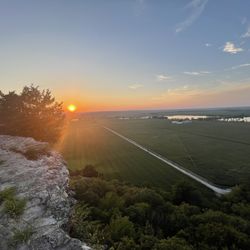
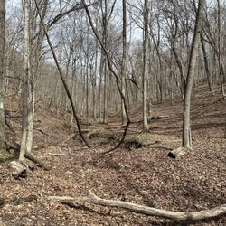
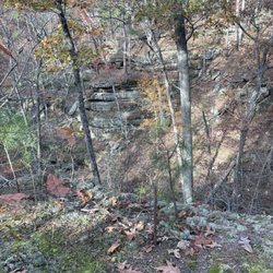
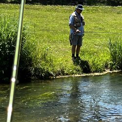
Don Robinson state park is an amazing place to hike and it's less than an hour away from St. Louis (about 45 minutes from my place in south city). The amenities include: a real bathroom with a flushing toilet (not just a porta-potty), well marked trails, and a nice lookout area (with a covered pavilion, picnic tables, and even a few rocking chairs). There are two hikes here: Sandstone Canyon trail and LaBarque Hills trail. LaBarque Hills is nice; it has lots of hills and views, follows a small creek for part of the hike, and is very peaceful. It's a 2.4 mile loop, rated as moderately difficult, and has an estimated hiking time of 1 hour 46 minutes. The reason I wanted to write a review, though, is Sandstone Canyon trail. That's where it's at! This is my absolute favorite hike in the St. Louis area. It's a 3.9 mile loop, rated as moderately difficult, and has an estimated hiking time of 2 hours 53 minutes. It takes you through all these cool rock formations and forest-y area and this amazing canyon part where you can see how the water carved a path through the rock. Some tips to keep in mind: bring water, bring your own trash bag (they don't have trash cans on the trails, only at the bathroom), and if it's been rainy before your hike, wear shoes you don't mind getting dirty. The trail crosses over a little water multiples times and can get real muddy. You're allowed to bring your dog on the trails as long as they're leashed. Sandstone Canyon trail is also paved and ADA accessible for the first 0.6 miles. The only downside to Don Robinson is probably the limited parking. Make sure you get there early if you're going on a weekend!

This is one of the best trails within a half hour of St. Louis and all of Missouri in my humble opinion. Dan Robinson State Park has two different trails that you can hike one is around 5 miles. The other one is about 2 1/2 miles. It has beautiful views and lots of Interesting formations. Don Robinson really gave the state of Missouri a great gift when he left his property to the state. It's somewhere around 5 to 700 acres with some very interesting flora and fauna that you can't find elsewhere in the state. It's a shame to see his old house in the condition it's in. I understand that the state is going to try to rebuild it. I can remember in the 1980s hanging out at Dan's house and skateboarding his enormous in-ground pool. He was quite the character. I highly recommend this park read more


3 years ago
Don Robinson state park is an amazing place to hike and it's less than an hour away from St. Louis (about 45 minutes from my place in south city). The amenities include: a real bathroom with a flushing toilet (not just a porta-potty), well marked trails, and a nice lookout area (with a covered pavilion, picnic tables, and even a few rocking chairs). There are two hikes here: Sandstone Canyon trail and LaBarque Hills trail. LaBarque Hills is nice; it has lots of hills and views, follows a small creek for part of the hike, and is very peaceful. It's a 2.4 mile loop, rated as moderately difficult, and has an estimated hiking time of 1 hour 46 minutes. The reason I wanted to write a review, though, is Sandstone Canyon trail. That's where it's at! This is my absolute favorite hike in the St. Louis area. It's a 3.9 mile loop, rated as moderately difficult, and has an estimated hiking time of 2 hours 53 minutes. It takes you through all these cool rock formations and forest-y area and this amazing canyon part where you can see how the water carved a path through the rock. Some tips to keep in mind: bring water, bring your own trash bag (they don't have trash cans on the trails, only at the bathroom), and if it's been rainy before your hike, wear shoes you don't mind getting dirty. The trail crosses over a little water multiples times and can get real muddy. You're allowed to bring your dog on the trails as long as they're leashed. Sandstone Canyon trail is also paved and ADA accessible for the first 0.6 miles. The only downside to Don Robinson is probably the limited parking. Make sure you get there early if you're going on a weekend! read more


 - Hiking Near Me - Cedar Hill, Missouri")


 - Hiking Near Me - Cedar Hill, Missouri")
2 years ago
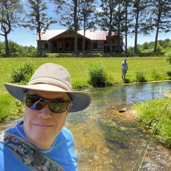
COVID review What a GEM!! Wonderful park close to STL. 800+ acres and 2 nice trails. We did the western loop of the sandstone canyon trail and the kids had a blast. There were tons of streams to cross and caves to explore. We came on a Sunday at 930am and the lot was already filling up. When we left by noon the place was packed! Established in 2012 this is a new park with great paved trails for some parts that are even wheelchair accessible. Also really nice bathrooms that were heated and had warm water to wash your hands!! What a bonus. Can't wait to come back and explore some more. Come check it out and stay safe with social distancing. read more


4 years ago
4 years ago
7 years ago
More info about Don Robinson State Park
Ask the Community - Don Robinson State Park


Why does Yelp recommend reviews?
1 review that is not currently recommended
The reviews below are not factored into the business's overall star rating.
6 years ago
Don Robinson State Park - hiking - Updated July 2026
Best of Cedar Hill
People found Don Robinson State Park by searching for…
Things to Do in Cedar Hill, MO
River Swimming in Cedar Hill, MO
Hiking Trails in Cedar Hill, MO
Beautiful Views in Cedar Hill, MO
Scenic Overlook in Cedar Hill, MO
Places to Take Pictures in Cedar Hill, MO
Off Road Trails in Cedar Hill, MO
Fishing Spots in Cedar Hill, MO
Scenic Views in Cedar Hill, MO
Secret Spots in Cedar Hill, MO
Lakes & Ponds in Cedar Hill, MO
Walking Trails in Cedar Hill, MO
Swimming Lakes in Cedar Hill, MO
Watch Sunset in Cedar Hill, MO
Scenic Drive in Cedar Hill, MO
Dog Friendly Hiking Trails in Cedar Hill, MO
Trending Searches in Cedar Hill, MO
Caves near Don Robinson State Park
Kayak Rental near Don Robinson State Park
Lakes near Don Robinson State Park
Lookout Points near Don Robinson State Park
Off Road Trails near Don Robinson State Park
Outdoor Activities near Don Robinson State Park
Places To Swim near Don Robinson State Park
Public Shower near Don Robinson State Park
River Swimming near Don Robinson State Park
Scenic Overlook near Don Robinson State Park
Secluded Spots near Don Robinson State Park
Splash Pad near Don Robinson State Park
Browse Articles
Browse Nearby
Browse Brands
Related Searches in Cedar Hill, MO
Affordable Kayak Rental Services in Cedar Hill, Missouri
Affordable Long Term RV Parking in Cedar Hill, Missouri
Best Dog Hiking Trails Around Cedar Hill, Missouri
Best Fishing Locations and Guides in Cedar Hill, Missouri
Best Parks for Parties and Events in Cedar Hill, Missouri
Best Places for Horseback Riding in Cedar Hill, Missouri
Best Water Parks for Kids in Cedar Hill, Missouri
Check Out Great Playgrounds in Cedar Hill, Missouri
Check Out Off Road Trails in Cedar Hill, Missouri
Discover Baseball Fields Around Cedar Hill, Missouri
Discover Dog Friendly Trails to Explore in Cedar Hill, Missouri
Discover Lakes & Ponds to Explore in Cedar Hill, Missouri
Discover Popular Bike Trails in Cedar Hill, Missouri
Discover Popular Photo Spots in Cedar Hill, Missouri
Discover Scenic Mountain Bike Trails Near Cedar Hill, Missouri
Discover Soccer Fields in Cedar Hill, Missouri Near You
Discover Top Nature Parks to Visit in Cedar Hill, Missouri
Discover a Hiking Trail in Cedar Hill, Missouri
Discover the Best Beaches in Cedar Hill, Missouri
Discover the Best Fishing Lake in Cedar Hill, Missouri
Discover the Best Night Hike Trails in Cedar Hill, Missouri
Dog-Friendly Hikes With Dogs in Cedar Hill, Missouri
Enjoy Camping Adventures Around Cedar Hill, Missouri
Enjoy Hiking Adventures in Cedar Hill, Missouri
Enjoy Off Leash Dog Hikes in Cedar Hill, Missouri
Enjoy the Best Walking Trails in Cedar Hill, Missouri
Experience Stunning Sunset Views in Cedar Hill, Missouri
Explore Beautiful Parks and Green Spaces in Cedar Hill, Missouri
Explore Bike Rentals Throughout Cedar Hill, Missouri
Explore Children's Museums Near Cedar Hill, Missouri
Explore Easy Hikes Perfect for All in Cedar Hill, Missouri
Explore Free Picnic Areas Around Cedar Hill, Missouri
Explore Fun Activities to Do in Cedar Hill, Missouri
Explore Parks With Pull Up Bars in Cedar Hill, Missouri
Explore Picnic Parks Near Cedar Hill, Missouri
Explore Popular Campgrounds Near Cedar Hill, Missouri
Explore Popular Picnic Areas Around Cedar Hill, Missouri
Explore Popular RV Parks Around Cedar Hill, Missouri
Explore Popular Recreation Centers Around Cedar Hill, Missouri
Explore Scenic Lakes to Visit in Cedar Hill, Missouri
Explore Top Dog Parks in Cedar Hill, Missouri Near You
Explore Top Trampoline Parks in Cedar Hill, Missouri
Explore Top Water Parks in Cedar Hill, Missouri Today
Explore the Best Boating Spots in Cedar Hill, Missouri
Explore the Best Swimming Holes Around Cedar Hill, Missouri
Family Friendly Hiking With Kids in Cedar Hill, Missouri
Find Great Places to Feed Ducks in Cedar Hill, Missouri
Find Parks and Recreation Activities in Cedar Hill, Missouri
Find Popular Ziplining Spots Around Cedar Hill, Missouri
Find Top Skate Parks in Cedar Hill, Missouri for All Skill Levels
People who viewed Don Robinson State Park also viewed
Mastodon State Historic Site
45 reviews
Greensfelder Park
6 reviews
Klondike Park
35 reviews
Chesterfield Central Park
26 reviews
Sherman Beach Park
2 reviews
Rock Hollow Trail
5 reviews
Homer F Stemler Memorial Walking Trail
6 reviews
Bluff View Park
1 review
Al Foster Trail
7 reviews
Monarch-Chesterfield Levee Trail
3 reviews