1. Driftwood At The Beach

    0

    Pistol River, OR

    Cancel

    Open app

    Search

    Driftwood At The Beach

    1.0 (3 reviews)

    Driftwood At The Beach Photos

    You might also consider

    Recommended Reviews - Driftwood At The Beach

    Your trust is our priority, so businesses can't pay to alter or remove their reviews. Learn more about reviews.
    Yelp app icon
    Browse more easily on the app
    Review Feed Illustration

    14 years ago

    Helpful 4
    Thanks 0
    Love this 1
    Oh no 0

    14 years ago

    Helpful 3
    Thanks 0
    Love this 3
    Oh no 0
    Photo of Amy F.
    189
    73
    6

    14 years ago

    Helpful 4
    Thanks 0
    Love this 2
    Oh no 0

    Verify this business for free

    Get access to customer & competitor insights.

    Verify this business

    Lone Ranch Beach

    Lone Ranch Beach

    5.0(14 reviews)
    22.8 mi

    While visiting Redwood National Park from the Bay Area, I decided to go a little further north and…read moresee the Oregon coast. A quick glance at beaches not too far over the border showed Lone Ranch Beach as a quieter local favorite. Well signed turn off took us here right off the 101. There were only a few other cars. What a gorgeous, dramatic beach! Tons of driftwood, sea stacks and forest that comes right up to the water. Walking along here was a lovely, peaceful way to spend an afternoon on the coast. There were several picnic tables on the grassy area before the beach and it seems like a great place to spend the day if you're local. Very glad I found my way up here!

    One of many beaches in Brookings OR…read more The beach is part of the Samuel H. Boardman State Scenic Corridor in Brookings OR, a little further drive down after crossing the CA/OR stateline. We turned in the parking lot but it was full, luckily, we found a spot (well, we kinda made our own spot) LoL! We attempted to walk down to the beach following a trail to the left but it was somewhat unpredictable and a little dangerous so we turned around. The path to the right has a better access to the beach but we didn't go. Instead we just took in the coastal views from atop and watched the crashing ocean waves hit the offshore rocks. The beach features many scenic sea stacks too. There is a picnic area at the site. February weather was exceptionally sunny, no rain in sight, but it was windy. Wish we had time to check out the tide pools but it was high tide when we went. Review #2525

    Photos
    Lone Ranch Beach
    Lone Ranch Beach
    Lone Ranch Beach

    See all

    Endert's Beach

    Endert's Beach

    4.5(16 reviews)
    52.9 mi

    While on a road trip, I had dinner then walked around here. The reason I took 1 star off was…read morebecause of some trash and lots of dead crabs / crab shells on the beach. I did not go into the water, fish or sit around the bon fire, but I am sure those things are fun to do here. It was easy to find parking.

    Years ago, long before Mrs. Picante del Monte and I tied the knot, we took the long drive north to…read moreJedediah Smith Redwoods outside of Crescent City, CA to camp and hike and cook over fire and do boyfriend & girlfriend kinda stuff. An outdoorsy gal to match my own granola-ish tendencies, she chatted up a couple of locals at the gas station about nice beaches in the area. An old gnarly hippie, who most likely spoke Boontling as his native tongue, told us about Enderts Beach on the south side of town, and off we went to seek our own insular Tahiti in the cool, perpetual overcast of extreme NorCal. We pulled off Hwy 101 and started down the long stretch of two lane highway, flanked by blackberry briars and wildflowers, to a nondescript turnout and a deer path heading out toward the dunes. Soon, we were walking through long-standing spider webs, as garter snakes skirted across our path, appearing and disappearing just as quickly in the thick green blanket of grass and blackberry vines. Along the way, we picked handfuls of the wild berries and popped them in our mouths, savoring the sweetness of the fruit, and the equally satisfying beauty and solitude of this place. Just a few yards from the trail, a black bear busied herself with her own berry gorging, seemingly oblivious to our passing. Truly, this was one of the most wild and untouched places we had ever been, and so close to the highway. The beach itself is wide and clean, heavily influenced by the tide and the relentless surf that pounds this part of the California coast into submission. Sand crabs, sand dollars, shorebirds, and--at high tide with the right bait-- red tailed surf perch are plentiful. An osprey hunting fish outside the surfline was a welcome sight, as was the occasional bear that would lumber along where the blackberries met the sand. Lots of driftwood, agates on the rock piles, and sea glass polished by the surf made beach combing productive. SoCal beaches can't even begin to compare to this level of natural beauty, even off the beaten path spots like Padaro, Blacks, and El Capitan. If you ever have the chance to enjoy a beach like Enderts or many other spots from Southern Oregon down along the Lost Coast of California, please take a moment to see nature as the Great Programmer intended it. It truly is a Thin Place-- a location where the distance between heaven and earth are significantly closer than average.
    Photos
    Endert's Beach - A white blackberry blossom and a beach backdrop

    A white blackberry blossom and a beach backdrop

    Endert's Beach - The sandy beach through the pines

    The sandy beach through the pines

    Endert's Beach - Sunset at Endert's Beach/Crescent Beach Picnic Area.

    See all

    Sunset at Endert's Beach/Crescent Beach Picnic Area.

    Myers Creek Beach - Meyers Beach sign next to Route 101.

    Myers Creek Beach

    5.0(1 review)
    8.8 mi

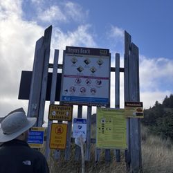
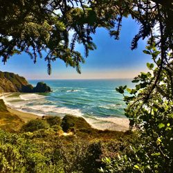
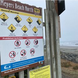
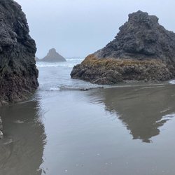
    The spelling of this beach, as shown in the title created by YELP, is not correct. Also, the…read morespelling of this beach, as shown on GOOGLE maps, is not correct. The correct spelling is MEYERS BEACH (please see my photograph of the big sign next to this beach). Strangely enough, the YELP website will not accept any posts unless the name of the place matches the spelling on GOOGLE maps. And so, in order to post this review, I am forced to accept the incorrect spelling, "Myers." Let me put this another way. If I go to YELP, and try to search for my review using the correct spelling, "MEYERS BEACH," YELP will not cooperate. But if I go to YELP and type the incorrect spelling (Myers Creek Beach), then YELP will coopreate. MEYERS BEACH NEXT TO ROUTE 101.   Our road trip to Gold Beach included taking the trail through Lady Bird Grove, taking the Skunk Cabbage Trail at Redwoods National Park, taking the trail up and down Trinidad Head (a sea stack in Trinidad), viewing Battery Point Lighthouse in Crescent City.  At Gold Beach, we stayed at Pacific Reef motel (see my YELP review of this motel).  Early the next day, we returned to Route 101 and headed back home.  As part of this return trip, we took Skunk Cabbage Trail (see my YELP review of this trail) and then stopped at nearby Meyers Beach. PHOTOGRAPHS OF MEYERS BEACH.  My photos show, ( 1 ) MEYERS BEACH sign standing next to Route 101; ( 2 ) View of distant sea stacks from the little trail next to Route 101; ( 3 ) Close up view of three small sea stacks.  I took this photo while standing on the wet sand; ( 4 ) Close-up view of four sea stacks.  I took this photo while standing in the water.  My goal was to get a photograph of the interesting pattern produced when two separate ocean waves (each approaching from a different side of one sea stack) met at the side of the sea stack where I was standing, and crashing into each other;  ( 5 )  Panoramic view of Meyers Beach.  Two birds are at the center of the photo.  It is early morning, and the entire area is covered with fog. ORIGIN OF SEA STACKS.  Sea stacks are formed by erosion of headlands (peninsulas) at the edge of the Pacific Ocean.  As waves approach the shore, they are bent so that, instead of moving towards the shore, they move parallel to the shore.  As a result of the waves moving parallel to the shore the crash into the sides of the peninsula (instead of into the very end of the peninsula).  As a result of this crashing, the sides are completely eroded away, resulting in the free-standing tip of the peninsula.   This free-standing tip is the sea stack.  Regarding the subject of physics of waves, including light waves and ocean waves, the word "refraction" refers to situations where the wave is bent.  Wherever you find a sea stack, it is likely that a ridge projected as a headland only a few thousand years ago (see, Flynn 2003). Sea stacks have particular advantages for use as a tool for measuring erosion of the mainland, where the result of removal is disappearance of beaches and of chunks of cliffs near the seashore.  These advantages are that sea stacks are tall and thin (making it easy to use them as a distinct reference point), and they are widely distributed parallel to the coast.  In addition, the age of sea stacks can be estimated by their distance from the coast (see, McPhillips and Scharer 2021).  Large arches in the ocean originated from sea stacks, where erosion of the sea stack created a tunnel (see, page 33 of Lund).  Using a particular sea stack as a stable marker, it has been determined that erosion of Oregon beaches is about one foot per year (see, page 34 of Dicken).  Some sea stacks are connected to a sea cliff by a thin strip of sand.  This strip of sand is called a, "tombolo" (see, Ehlen).   Squaw Island near Sunset Bay is a sea stack with a tombolo.  In addition to sea stacks, off-shore geological formations include, skerries, marine benches, growlers, and boilers (see, Finkl and Makowski).  A skerry, for example, is a very short sea stack that is too small for human habitation.   REFERENCES  ( 1 ) Kathryn Flynn (Aug. 2003) The Dynamic Oregon Coast: Geologic Features and Where to See them.  Geological Society of America and the USDA Forest Service; ( 2 ) Samuel Dicken (Nov. 1961) ) Some Recent Physical Changes of the Oregon Coast. See, pages 8, 26, 34, and 38, of this 76-page article; ( 3 ) Judi Ehlen (April 1967) Geology of State Parks Near Cape Arago. The Ore Bin. Vol. 29, No. 4 (pages 61-84); ( 4 )  Ernest Lund (Feb. 1971) Coastal Landforms Between Florence and Yachats, Oregon. Vol. 33, No. 2 (28 pages); ( 5 )  McPhillips and Scharer (Sept. 2021) Survey of Fragile Geologic Features and their Quasi-Static Earthquake Ground-Motion Constraints, Southern Oregon.  Bulletin of the Seismological Society of America; ( 6 )  Finkl and Makowski (2021) Along shore classificaiton ad morphometric analysis of coastal belts: The State of Oregon.  J. Coastal Research. 37:238-27

    Photos
    Myers Creek Beach - Myers beach

    Myers beach

    Myers Creek Beach - Big sign reading MEYERS BEACH.   This sign is standing at the edge of Route 101.

    Big sign reading MEYERS BEACH. This sign is standing at the edge of Route 101.

    Myers Creek Beach - View of three sea stacks.  I took this photo while standing on the wet sand.

    See all

    View of three sea stacks. I took this photo while standing on the wet sand.

    Driftwood At The Beach - beaches - Updated September 2026

    Loading...
    Loading...
    Loading...