Gerbode Valley Loop Hike Photos


You might also consider
More like Gerbode Valley Loop Hike
Recommended Reviews - Gerbode Valley Loop Hike
Start your review...

5 years ago
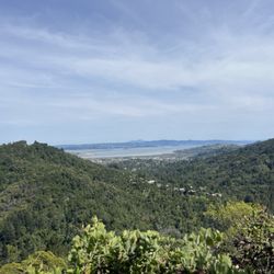
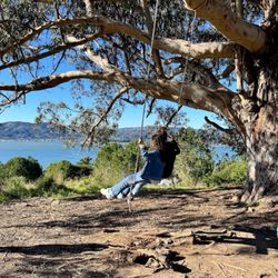
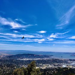
First time ever to this location. Went through a one way tunnel. Easily found the Smith road turnoff to the parking lot. Also great clear signs further up to find the Visitor center near the top of the hill. There are more restrooms there if you need to go. I am not sure if the Visitor Center is open now? But I know there's a nice mini history of natives Museum inside. Anyway my group decided to find easier parking if we just all drove to Smith Road to begin our hike at that main location instead since parking is very limited at Visitor Center. Half the section is only 30 minutes parking. FYI- no cell phone reception in this area since you are surrounded by nature. Make sure your entire group carpool or know the spot to meet up. There's one restroom here. At start of trail we looked at map and we were going to do the 3 hour Gerbode Valley Loop from Bobcat Trail, Milwok Trail and Rodeo Vally Trail. We crossed the nice wooden bridge and started the light incline easy walkable, which was good. Surprised to see a running back down and a cyclists coming up. No shade in this section. I see views of mountains and to the right the tip of a Golden Gate Bridge pops up and you can see some of Downtown SF on right side. Eventually we came to a fork in road. We stopped for photos and then went back on the Bobcat Trail where got some nice shaded part of trees! Nice ! Thank you for the shade! Felt like we were in an another part of a forest, feeling cool, calm collective with fresh air! I loved the views of the Sausalito Bay and Hwy 1. You can just chill and relax here. Then rest of the hike is a nice gradual decline with not shade, so make sure you wear your sun hat. I was happy eating my apples, nuts and snacks and my water bottles to make sure I am well hydrated. I am proud I completed this hike with my buddies. Exercise is important to be healthy! Great hike with good views. Marin has pretty landscape! Will love to come back to explore more like Rodeo Beach and lighthouse! read more


This is the perfect "moderate" hike. Enough climbing to get your heart pumping but at accessible grades, great views of coast and pastoral landscapes, wildflower and wildlife watching, and wide smooth dirt trails with even footing the whole way. There is light traffic (hikers, bikers, and horseback riders) the whole way but it never feels crowded. I think this is a great hike to do with visitors who aren't die hard hikers. read more

More info about Gerbode Valley Loop Hike
931 Bunker Rd
Mill Valley, CA 94941
Directions
Hours
Outdoor Amenities
You might also consider


Gerbode Valley Loop Hike - hiking - Updated June 2026
Best of Mill Valley
People found Gerbode Valley Loop Hike by searching for…
Beaches in Mill Valley, California
View Points in Mill Valley, California
Visitor Centers in Mill Valley, California
Flower Fields in Mill Valley, California
Hiking Trails in Mill Valley, California
Easy Hikes in Mill Valley, California
Lighthouses in Mill Valley, California
Walking Trails in Mill Valley, California
Running Trails in Mill Valley, California
Things to Do in Mill Valley, California
Hiking Club in Mill Valley, California
Redwood Forest in Mill Valley, California
Night View in Mill Valley, California
Lookout Points in Mill Valley, California
Views in Mill Valley, California
Sunset Views in Mill Valley, California
Scenic Overlook in Mill Valley, California
Shaded Hike in Mill Valley, California
Swimming Lakes in Mill Valley, California
Things to See in Mill Valley, California
Photo Spots in Mill Valley, California
Waterfall in Mill Valley, California
Trending Searches in Mill Valley, CA
Beaches near Gerbode Valley Loop Hike
Black Owned Nail Salons near Gerbode Valley Loop Hike
Boat Rental near Gerbode Valley Loop Hike
Cliff Jumping near Gerbode Valley Loop Hike
Dog Friendly Things To Do near Gerbode Valley Loop Hike
Fishing Spots near Gerbode Valley Loop Hike
Free Kids Activities near Gerbode Valley Loop Hike
Jet Ski Rental near Gerbode Valley Loop Hike
Lakes near Gerbode Valley Loop Hike
Outdoor Activities near Gerbode Valley Loop Hike
Parks near Gerbode Valley Loop Hike
Pick Your Own Farms near Gerbode Valley Loop Hike
Picnic Areas near Gerbode Valley Loop Hike
Public Pools near Gerbode Valley Loop Hike
Public Shower near Gerbode Valley Loop Hike
Rock Quarry near Gerbode Valley Loop Hike
Running Trails near Gerbode Valley Loop Hike
Scenic Drive near Gerbode Valley Loop Hike
Secluded Spots near Gerbode Valley Loop Hike
Splash Pad near Gerbode Valley Loop Hike
Strawberry Picking near Gerbode Valley Loop Hike
Summer Camps near Gerbode Valley Loop Hike
Sunrise View near Gerbode Valley Loop Hike
Swimming Holes near Gerbode Valley Loop Hike
Swimming Lakes near Gerbode Valley Loop Hike
Swimming Pools near Gerbode Valley Loop Hike
Watch Sunset near Gerbode Valley Loop Hike
Browse Articles
Browse Nearby
BEST of Mill Valley, California Things to Do near Gerbode Valley Loop Hike
BEST of Mill Valley, California Restaurants near Gerbode Valley Loop Hike
BEST of Mill Valley, California Coffee near Gerbode Valley Loop Hike
BEST of Mill Valley, California Beaches near Gerbode Valley Loop Hike
BEST of Mill Valley, California Breakfast near Gerbode Valley Loop Hike
BEST of Mill Valley, California Picnic Areas near Gerbode Valley Loop Hike
BEST of Mill Valley, California Campgrounds near Gerbode Valley Loop Hike
Browse Brands
Related Searches in Mill Valley, CA
Affordable Kayak Rental Services in Mill Valley, California
Best Fishing Locations and Guides in Mill Valley, California
Best Nature Trails for Hiking in Mill Valley, California
Best Places for Horseback Riding in Mill Valley, California
Check Out Off Road Trails in Mill Valley, California
Discover Dog Friendly Trails to Explore in Mill Valley, California
Discover Kid Friendly Hiking Trails in Mill Valley, California
Discover Scenic Hiking Trails in Mill Valley, California
Discover Scenic Mountain Bike Trails Near Mill Valley, California
Discover Scenic Waterfall Spots in Mill Valley, California
Discover Top Nature Parks to Visit in Mill Valley, California
Discover Walking Parks in Mill Valley, California Near You
Discover a Hiking Trail in Mill Valley, California
Discover the Best Night Hike Trails in Mill Valley, California
Discover the Best Running Track in Mill Valley, California
Dog-Friendly Hikes With Dogs in Mill Valley, California
Enjoy Camping Adventures Around Mill Valley, California
Enjoy Kayaking Adventures in Mill Valley, California
Enjoy Tent Camping Spots Around Mill Valley, California
Enjoy a Beautiful Waterfall Hike in Mill Valley, California
Enjoy the Best Picnic Spots and Ideas in Mill Valley, California
Enjoy the Best Walking Path in Mill Valley, California
Enjoy the Best Walking Trails in Mill Valley, California
Exciting Cliff Jumping Spots in Mill Valley, California
Explore Beautiful Parks and Green Spaces in Mill Valley, California
Explore Easy Hikes Perfect for All in Mill Valley, California
Explore Fun Activities to Do in Mill Valley, California
Explore Popular Campgrounds Near Mill Valley, California
Explore the Best Beach Spots in Mill Valley, California
Explore the Best Swimming Holes Around Mill Valley, California
Explore the Best Trail Options in Mill Valley, California
Family Friendly Hiking With Kids in Mill Valley, California
Find Beautiful Views in Mill Valley, California
Find the Best Parks for Picnics in Mill Valley, California
Find the Best Scenic View Locations in Mill Valley, California
Great Places to Walk in Mill Valley, California
Hike the Popular Waterfall Trail in Mill Valley, California
Hiking Trails With Waterfalls in Mill Valley, California
Off Leash Dog Hiking Trails in Mill Valley, California
Plan a Scenic Drive Route Near Mill Valley, California
Popular Outdoor Activities to Try in Mill Valley, California
Popular Picnic Spots to Visit in Mill Valley, California
Safe River Swimming Areas in Mill Valley, California
Safe and Fun Parks for Kids in Mill Valley, California
Top Climbing Spots and Gyms in Mill Valley, California
Top Running Trails to Explore in Mill Valley, California
Top Swimming Lakes to Enjoy in Mill Valley, California
Top Swimming Spots and Pools in Mill Valley, California
Walk Dog Friendly Hiking Trails in Mill Valley, California
Walk the Best Paved Walking Trails in Mill Valley, California
People who viewed Gerbode Valley Loop Hike also viewed
San Andreas Trail
20 reviews
Sign Hill Park
60 reviews
Painted Rock
1 review
Sea Cliff
Double Cross Trail
5 reviews
Lakeshore
Bay Trail
17 reviews
San Bruno Mountain Watch
5 reviews
Centennial Way Trail
21 reviews
Quarry Road Pedestrian Trail
1 review
Point San Bruno Park
6 reviews
Crane Cove Park
19 reviews
Dogpatch, Potrero Hill