Cancel

    Open app

    Search

    Grice Car and Clearfield Community Museum

    5.0 (1 review)

    Grice Car and Clearfield Community Museum Photos

    More like Grice Car and Clearfield Community Museum

    Recommended Reviews - Grice Car and Clearfield Community Museum
    Your trust is our priority, so businesses can't pay to alter or remove their reviews. Learn more about reviews.
    Yelp app icon
    Browse more easily on the app
    Review Feed Illustration

    4 years ago

    Helpful 1
    Thanks 0
    Love this 1
    Oh no 0

    Verify this business for free

    Get access to customer & competitor insights.

    Verify this business

    Penn's Cave & Wildlife Park - Gift Shop

    Penn's Cave & Wildlife Park

    4.4(123 reviews)
    44.0 mi

    A terrific place to spend a day and an outstanding value…read more My wife and I took a day trip (7/26/26) to visit and would certainly recommend it. We purchased the combo ticket for the cave tour and wildlife experience. Both were excellent. The cave tour is by boat, and we were piloted by a knowledgeable, spirited guide. And the cave is really kind of breathtaking. (We had a noon cave tour) The wildlife park tour is on a bus and again our driver was engaging and fun. The animals are well cared for, and not confined to small cages. They have space to roam and be animals. (Our park tour was 2 pm.... I mention the times so management can credit the guides if they read these reviews and do that sort of thing.) While we went for a couple's road trip, the visitors are definitely mostly families. So there are a fair amount of young ones around. Mostly, they just seemed fascinated with the cave and the animals.

    Penn's Cave has been offering guided boat tours for over 140 years and it's easy to see why it's…read morestill such a popular stop. Located in Centre County, PA (which apparently has over 130 caves!), this unique tour takes you through a beautiful limestone cavern entirely by boat. The cave tour lasts about 45 minutes and costs $25 per person. They also offer a wildlife tour by bus, but we only had time for the cave portion. Be aware there's a fairly large staircase you'll need to go down to reach the cave entrance. Something to keep in mind if anyone in your group has mobility issues. Each boat holds around 22 people, but we visited on a quiet Monday afternoon and only had 8 in our group, which made it feel more personal. Our tour guide was excellent and knowledgeable, engaging, and had a sense of humor. He encouraged questions and had thoughtful answers for everything we threw at him. At the end of the cave, you actually exit into a small lake, take a brief spin around, and then head back through the cave to where you started, very cool and peaceful. There's also a gift shop on-site that sells snacks, drinks, and the usual souvenirs. Tours typically depart every 30 to 60 minutes depending on how busy they are, so timing is pretty flexible. All in all, it's a fun, unique experience that's well worth the stop!

    Photos
    Penn's Cave & Wildlife Park
    Penn's Cave & Wildlife Park
    Penn's Cave & Wildlife Park

    See all

    Laurel Highlands Hiking Trail - Rte. 271 trailhead during 2017 LHHT Ultra marathon.

    Laurel Highlands Hiking Trail

    4.7(3 reviews)
    51.7 mi

    I spent 3.5 days and 3 nights on this trail this past memorial day weekend, my first venture back…read moreinto the backpacking world. This trail begins in Ohiopyle or Johnstown and ends whichever way you choose. If I were to try to pack the entire length I would start at the North end in Johnstown and hike South, to ease up the ankle pain and knee pain :) That comes with packing 20lbs + pack weight and hiking 18-19 miles in one day. Throw in the elevation gain and you will see what I mean. I hiked the South end starting in Ohiopyle and going out to about 26 miles over my time there, then I turned around and came back over two days. Things to note for overnight campers: You can call ranger station at trailhead to make your camping reservation, by credit card it is 4$ a night. Water: there is non drinking water at each campsite, bring a water filter or boil that water as it is not tested. I filtered stream water the whole time and it was fine. Ohiopyle about 6 miles in has the nicest camping ground with access to a large stream, but not all the sites have that. You might want to filter water for night hiking into camp. To save hiking a mile extra back out to get some as I had to do. Firewood, there are fire pits in the shelters if you want to skip the tent but bring something to lock your food up, mice are common in the shelters. I slept in a tent kept my back in the tent with me. There are portapotty type johns at the campsites. Weather: if you check local forecast plan on temps on the trail and at camp at night being around 10 degrees colder because of the elevation change, and storms. Bring rain gear if you're out for more than a day hike! Now for the trail, it is blazed yellow on the trees hard to get lost but a map would have been nice to have. However no maps available in Ohiopyle you have to pay for one at the Laurel State Park office. I did not do that would rather buy a hiking book with the trail in it at a later time. In most places its wide very rocky, lot of tree roots its murder on the soles of your feet, wear boots or stiff soled shoes if hiking for more than one day. Poles could come in handy, I don't use hiking poles but I got caught in little thunderstorm and had to grab a forest walking stick. Some places it looked like they barely blazed a trail at all it was very narrow hard to hike on. Hike with caution. Beautiful river runs stream runs, skyline views, and rock formations. In the first 26 miles views are at mile 6 ish and 24ish, rocks b between 15-20. Lots of birds, and small wildlife I only saw one deer. There is a shooting range at mile 25, just outside the park you will hear lots of gunshots. I would not recommend taking a break or relax day at the Grindle ridge campground out there as I did. Also the campgrounds that have broken water pumps currently are Grindle Ridge and Route 653 shelters campground. This is a lovely hiking trail but steep, be prepared for a challenge in the beginning. Happy Trails!

    How can you not LOVE the LHHT? Its a trail I've frequented quite often in the last 15 years, and…read morehope to explore the entire 70 miles. This picture was taken during the Laurel Highlands Ultra race in June 2017. This race can be run as a relay or individually. They also sponsor a 50k race, which is approx. 30 of the 70 miles. There are many trail heads and shelter areas. The trail is great for day hikes, as well as multiple overnight stays. There are also many ambitious people who hike the entire thing. Its always fun to pass fellow hikers on the trail. Trail stories are always fun to hear, and there are people from all over that you'll meet. Running the trail is quite a challenge, as there's drastic elevation changes at some points and many technical areas. I suggest if you've never run the trail, and expect to run the race, you must do at least 1-2 runs on the trail.

    Photos
    Laurel Highlands Hiking Trail - Rte. 271 trailhead during LHHT Ultra marathon 2017

    Rte. 271 trailhead during LHHT Ultra marathon 2017

    Laurel Highlands Hiking Trail - Finish for 2017 LHHT Ultra Marathon, Rte. 56, Seward, PA

    Finish for 2017 LHHT Ultra Marathon, Rte. 56, Seward, PA

    Laurel Highlands Hiking Trail

    See all

    Historic Hanna's Town

    Historic Hanna's Town

    4.0(3 reviews)
    73.3 mi

    My husband and I were driving home from the Westmoreland County arts and crafts festival and…read morediscovered Hanna's town as we were driving. The place was closing within 15 minutes but I had the opportunity to meet with a couple of staff and learn about the place. Hanna's Town is a national historic site not often noted during the pre and during the Revolutionary War. We learned that it was the first English court west of the Allegheny Mountains and this town had more prominence than Pittsburgh which had yet to be developed. The settlers adapted what was called the Hanna's town resolves which fueled the movement towards independence. It was also was an important site during the war recruiting men for the Continental Army and for the militia that aided the western campaigns against the Indian allies of the British. The actual town itself was burned by Indians and British allies in 1782 and a partial recreated village was built in its place to show the hard lives the early settlers had and the important part they played in achieving American Independence. A lady let us view a one room house with bare floors that had table and chairs, a bed, and a fireplace along with dishes and other things needed for a frontier lifestyle. One can only imagine what life must have been like in that period. I had an opportunity to tour the fort on the grounds and saw various items such as a fireplace, the frame of a TeePee, and a memorial to a 12 year girl by the daughters of the American Revolution who gave her lives to the Indians. With very little time we were allowed into the gift shop where they have additional artifacts about the town itself. They offer tours which last 1 1/2 hours and since they were closing asked us to return for one. Tours are only $5.00 but you can get $1.00 off if you are AAA member or Senior Citizen. I was given a pamphlet where I learned they host events, court reenactments, antique and collectibles markets and other things. This is definitely a must return trip since it will give me an opportunity to learn more about the colonial lifestyle. Located on Forbes Trail Road it is an easy drive to Greensburg.

    I found this on the 'Uncovering PA' facebook page as something to see in Pennsylvania so drove in…read more I loved how it was laid out and enjoyed wandering the fort, then up the hill to the very large rock! Across the street you find the stockade, schoolroom, and visitor center.. Sadly it was closed when I arrived but I did enjoy the buildings. I love history and these old buildings are amazing. I love old forts too ;)

    Photos
    Historic Hanna's Town
    Historic Hanna's Town
    Historic Hanna's Town

    See all

    McGee's Mill Covered Bridge

    McGee's Mill Covered Bridge

    3.0(1 review)
    19.9 mi

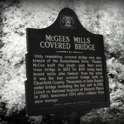
    PASSION - a strong feeling of enthusiasm, excitement or fondness for something…read more ----- I have been asked many times by other yelpers about my love for covered bridges and I didn't really have the answer. So I thought I would take a moment to explore my unconscious reasons and came up with an explanation of sorts. In the simplest of terms and the cleanest of definitions, I have a strong passion for things that last or endure against all odds. I am a total sucker for ANY movie that highlights fighting for what you believe and not letting obstacles and challenges overtake, limit or define you. Shawshank Redemption, Freedom Writers, The Help, The Blind Side, Pursuit of Happyness, Nell, Fault in Our Stars, The Longest Ride, The Color Purple, Wild, Slumdog Millionaire, the animated films UP / Cars / Despicable Me / Inside Out and yup, even Forrest Gump are all examples of a small population of movies that inspire me to love better, see the best in others, learning from my own mistakes and live like I mean it. So when you combine that with my desire for peace and harmony among all man, it makes sense that my love for covered bridges is as natural as breathing. Not only is a bridge symbolic of connecting two sides separated by a barrier or chasm, it can also represent overcoming obstacles and transitioning to a new destination. I suppose a bridge most represents hope, which would also explain why I feel it important to maintain them. ----- The sign near the bridge reads: "This is the last remaining bridge anywhere along the Susquehanna River" which I would assume would give it historical precedence to the local government. Its structural support has been extensively reinforced with steel making it strong enough to remain in service for vehicular traffic, but it could use serious refurbishment to freshen its appearance and extend it's life span. BRIDGE FACTS Year Built: 1873 Builder: Thomas McGee Length: 107 feet Renovated: 1978 & 1994 after being damaged by heavy snowfall Truss type: Burr Arch Location: West Branch of the Susquehanna in Mahaffey, Pennsylvania ----- FINAL THOUGHTS I drove considerably out of my way to view this bridge and found it to be a little disappointing. Despite its appearance in my pictures, this bridge is the very definition of putting lipstick on a pig. Someone has taken the time to paint it to make its appearance more attractive, but it shows signs of serious decay in the wood most exposed to the elements. I have to remind myself that people don't really care about stuff like this anymore. But I wish they did! I wish they cared about connections and bridging chasms not only in historic structures like this, but in our differences as well. Here's to all bridges of any kind and maintaining them. 2016/18

    Photos
    McGee's Mill Covered Bridge
    McGee's Mill Covered Bridge
    McGee's Mill Covered Bridge

    See all

    Grice Car and Clearfield Community Museum - museums - Updated August 2026

    Loading...
    Loading...
    Loading...