Hawaii Loa Ridge Trail Photos


You might also consider
More like Hawaii Loa Ridge Trail
Recommended Reviews - Hawaii Loa Ridge Trail
Start your review...

Reviews With Photos

Great trail, great view. The fog rolled in as we got close to the top but the views on the ways up were amazing the whole time!!!! Roots, rocky, muddy, big steps are included in this hike. You hike in and out of forested shaded areas to hot open areas that give you the views you crave. Only 10 cars are able to be parked at a time. So make sure you get there early. As people leave others can go up. You must have a Hawaiian ID or Mil ID to hike and sign a waiver. Bring water and snacks!!! As this is a climb! You will get thirsty.


Back a second time and still love this challenging trail with amazing views. Must have someone with Hawaii ID or Military ID to show security at private community gate to enter property to drive to trailhead which is on State land. There is limited parking so they limit how many cars come in at one time. We did early on week day hikes and have not had a problem. It nice not to have too many people on the trail especially in the stair section which has close quarters for passing. The conditions were slightly damp toward the top, and made for slightly slower progress, taking time to not slip. The trail is eroded in spots, with high step ups, because of steps missing. One areas was difficult to get up on because of the erosion, but with team work we all made it up. After the steep climb we were treated to an amazing view of the other side of island. Depending on cloud cover you may or may not see it. After sharing our lunch we started our journey down. We did use crampon for the steep section of the trail. We did make better time going back down however still need to be careful on our footing. Of course the young people that could be our grand children's age flew down the trail. We are happy we can still do trails that are rated hard at our age. Two of us near 70 and one over 70. I would not do this trail if raining, can become slick with the potential of water running down the trail. It so worth the challenge and absolutely stunning views.

I underestimated this trail due to it being shorter than Kuliouou Ridge and Wiliwilinui Ridge. In my opinion this trail difficulty is rank between the 2 with Kuliouou being the easiest of these bunch. It took me about 2 hours to get to the summit and another 2 hours going back. Also it started to rain a bit so I took my time along with my crampons and hiking sticks. The summit was covered in the clouds so there was no view. I will definitely go again to see it. The AllTrails app made it seem like you were 70%in the trail at the 45 minute mark. Don't be fooled as the last 10-15% of the trail is the hardest part as the ridge gets into a steep incline. Be ready to get on your butt and your hands dirty as it gets arduous. Theres areas that's sketchy with a hazardous cliffs. So be extra careful especially when it drizzles when you're close to the summit clouds. I will definitely go again to see the view at the summit. As always I bring hiking sticks to help with deceleration when going back down. Knee braces to keep your knees from hurting or slipping. Also bring enough water and snacks. I go on weekdays as the crowd is small and either go in early in the morning for the first batch or parking passes or around 11am - 12pm for the next batch. But you can always try your luck on weekends. Happy hiking!

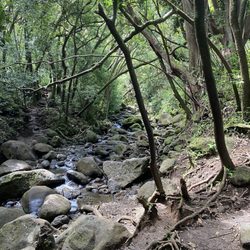
This was a challenging hike for me. Out of wiliwilinui, kuliouou, and hawaii loa ridge, this was the most difficult. We started at 7:30 am and ended almost at noon while taking our time and spending about 20 minutes at the top. Make sure to get there early to get a parking pass. The security guard will ask for your drivers license and have you and the people in your car sign a waiver. The trail itself is very beautiful but some parts are super eroded. I had to pull myself up a few times because my legs were too short to climb some of the stairs. There is also a narrow mud tunnel that was slippery in some parts. I would recommend doing this hike on a clear day and skip it if it's raining. Luckily the clouds cleared a bit at the top. Overall, I'd say the other two ridge hikes offer a similar view, are easier to access, and probably safer if you are a beginner or moderate hiker. Bring lots of water, a hiking stick, and gloves if you can. My hands were dirty and muddy after finishing this hike! I consider myself in decent shape but my legs and upper body hurt afterwards lol.

Having finally completed Wiliwilinui and Kuliouou Ridge Trails, I felt an urgency to complete Hawaii Loa Ridge Trail - the last ridge trail in the area. According to the All Trails app, Hawaii Loa Ridge is 4.5 miles out and back and rated as hard. When I hiked Wiliwilinui the week before, it was super muddy so when the hiking reports said the trails were dry I took off an afternoon off to explore Hawaii Loa Ridge. At the guard shack, you'll need to present your Hawaii state ID and sign a waiver to obtain a parking pass. I hear there are 10 parking passes available. That Thursday afternoon, I had pass #5. The trail is well maintained and easy to follow. Most of it is exposed so I was thankful for the cloud coverage that day. What I liked most about this trail is that there are beautiful views right away. I was pretty excited to be hiking a new trail so I started at a pretty fast pace and then I lost fuel 40 minutes in. That was when I reached the first steps. It took me another 50 minutes to reach the top as I struggled with the steep incline. I had read that when you reach the Hazardous Cliff sign you were steps away. I kept a look out for that sign and I was so happy and relieved when I finally saw it. There was no view at the summit as we were covered with clouds, but experiencing the same thing a week before at the Wiliwilinui summit just made me laugh. I met a couple of other hikers at the top and they were so nice to take my picture. I had to rush back home so I got back to my car in about an hour. It was a challenging hike, but totally possible, especially if you take it slow and steady. The least thing I liked about the trail were the narrow mud walls in some sections. As you can tell, I am not a fan of mud.

I came here at the suggestion of my friend who was staying in the subdivision where the house is located on a house sitting gig. She told me about this amazing hike just up the road from where she's staying that we should check out. I was game, so on a Thursday after work, I picked her up and off we went. Full disclaimer: We did not hike the entire trail. We hiked about 30 minutes of the trail before the views stopped due to entering the bush. Yes, there is a security booth you check in at, but because I went on a Thursday afternoon, there was no issue getting in. All I had to do was show my I.D. and let them know I was picking up my friend. I didn't mention we were going hiking, so perhaps that's why I wasn't required to sign a waiver. Getting up to the park is easy - you just follow the winding road up and up until you get to the top. The park up there is gorgeous - it reminded me of Napali lookout on Kauai. It was really windy when we went, but we didn't let that deter us from exploring the area. There's a small loop trail around the parking area where you can grill out at various grills or sit and enjoy the spectacular view from one of the benches. Once you enter the hike, it's easy to see why it's rated so highly. There's no huge elevation gain to achieve to enjoy payoff views pretty much right away. After coming out on the other side of the first ironwoods forest patch, you're greeted with gorgeous Portlock and Diamond Head views. Picture opportunities are ample. I would love to come back and do more of the ridge sometime. Given our time constraint, this fast and easy stretch of hike we completed was more than worth the drive up the mountain.

Tl;dr: come in dry season. Make sure you have a good couple of days of dry weather before you do it. Why? Because it's SO freaking muddy and slippery on the top 50% otherwise. Long pants are your friends to prevent bush poking. If rain hiking is your thing, wear hiking boots. First 50% of the trail is flat and damp (covered in leaves), and alternates between canopied and exposed. Once you get to the upper 50% it gradually becomes muddier and muddier. You have poorly maintained stairs with exposed nails. All fours are needed to get up certain parts without slipping. The trail also narrows significantly. As you go up the elevation it gets super windy too. When we were close to the top it was so rainy, windy, and muddy that we had to turn back (granted wearing tennis shoes didn't help in that situation). Trail wasn't hard but the muddiness + poorly maintained stairs at the end present real danger if you aren't geared up properly. A few guys we passed advised us to slide down on our butts and they weren't joking - the ass marks on the way down confirmed that LOL. Nice view but I've seen better. I'm all for strenuous hikes but mud just isn't my thing. Not on the top of my list to come back to. PS: the neighborhood surrounding these mountains is beautiful. If I can live anywhere on the island this would be on the top of my list.

This is one of my favorite hikes on Oahu. This hike is great if you are an intermediate or novice hiker. I don't recommend this hike for beginners because it's more than 3 miles long, and takes a bit of strength to get up, not to mention getting back down and out. Even if you are fit, something on your body WILL hurt after this hike, most likely are calves or quads (or perhaps your butt, from falling). More often than not this hike is a little muddy/slippery. I recommend shoes that have a bit of grip, at least a liter of water, and some kind of snack such as a granola or energy bar. The first half of the hike is usually sunny, with some areas that go through a forest of guava trees. If it's a humid day, you'll be inhaling lots of fruit flies. I know, super gross, but still true. If you're like me, I'd like to keep a good pace while hiking, he will most likely be sweating so you'll need a decent amount of water and definitely a snack. at the end. One of the best parts of this hike is about three fourths of the way in, turn around and you'll see beautiful views of the valley. One of my other favorite parts of this hike is the end, where you can sit at the top of the ridge right in the clouds. I definitely recommend this hike on a sunny or overcast day (but never rainy) as the trail gets a lot harder the wetter it is. Give yourself 3 to 4 hours for this hike.

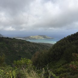
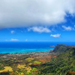
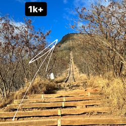
Really nice view at the top, but you gotta work for it; so don't give up half way. An intermediate to med/advanced hike depending on your level of fitness. The beginning is easy and relatively flat but at about 1/4 to 1/3 of the way it gets a bit steep with high stairs and slopes, some parts even have rope to assist you in the assent and more so the decent. The view from the top is just breath taking, a full view of most of the kailua coast, all the way from mokumanu to rabbit island! You can really see the crater too. http://www.yelp.com/biz_photos/fqadg9iecS-LqqYIqA8I-w?select=RijveSa5e6tE9ewRiOXBuw If it's cloudy the view might be obstructed (might not be able to see anything but clouds.) someone put some army men in the trees at the top, see if you can find them its kinda like where's Waldo. http://www.yelp.com/biz_photos/fqadg9iecS-LqqYIqA8I-w?select=LE8hTKhYZGWPiUEC4qd3Ow Hike took me 4 hours with stops and some time to take in the view at the top. Tips: 1. Hawaii State ID REQUIRED to pass the guard shack (Just 1 ID per car is okay) don't waste your time if you don't have one! 2. Only 10 cars allowed at a time so kokua and carpool. 3. Go early to avoid the sun, its difficult enough in the shade. (also because of #2) 4. Lots of water the more out of shape you are, the more water you need. 5. Hiking shoes required, up is okay, it's coming down that you'll really need it. 6. Consider canceling if its wet. Steep inclines and muddy is a bad idea.


Went on this trail a couple of times. The first time the trail was dry. It took our group about 3.5 hours up and back. The second time it was wet from beginning to end and it took us about 5.5 hours. This was with a 20 minute rest at the summit. What I like about this trail is that compared to the other nearby summit trails this is the quickest. Keep in mind that the last part of the trail is very steep! Limited parking at the trail head and once the parking stalls are filled, they won't let any other cars in to park at the trail head.

I think this hike by far the hardest for me because the ridge was too narrow. It is very similar to Wiliwili Nui Ridge but no ropes and steeper. Two of my family made it to the top and the other two including me didn't. And at this point I'm not sure if I will return to finish it. I did 90% of it but feels unaccomplished. Great view! You do have to guard shack at the entrance like Wiliwili Nui ridge and the guard will check for driver's ID and everyone has to sign the liability form. They only give out 10 passes at a time. Read all the information before you go. We came here on Christmas Day and there were only 6 parked cars. This park is well kept. It's probably because of the gated neighborhood that it is in called Hawaii Loa. As other hiker described "Boujee." But no public restrooms. read more


I've been on a hiking "kick" recently. I've never been on this hike, the views were worth it not to mention its a great workout. Get a parking pass from the guard shack when you enter you will need an ID. There's about 10 available stalls...or in my case I got lucky and my aunty's house is right next to the park entrance. It took me about 3.5 hours total but I took pictures, took breaks to catch my breath and ate a spam musubi at the top. The first 45 min or so was relatively easy that last 45 min to the top was more of a workout similar to koko head crater but not as many stairs. I would recommend water, hiking shoes and sunscreen. Hiking pants optional. There's an area that you will walk through foliage but its not thorny type just made my legs itch a little. Gorgeous hike up and the views are worth it! Its not a crowded hike since its limited parking great views! read more

10 months ago
Hawai'i Loa Ridge Trail is the one to do after Kuliouou. The views are even better and it's slightly more challenging. You'll need a Hawai'i-issued ID to get past the security gate, and parking is limited. Don't get discouraged if it's full because spots do open up if you're patient. Or, if you've got friends living up in Hawai'i Loa (lucky you), now's the time to call them. Think of it like Kuliouou, but with less shade, more intensity, and a bigger payoff at the summit. The first 60% is easy and feels more like a stroll. After that, you'll dip down before heading up a tougher stretch to the top. This is where the real workout begins, and where you might start questioning your life choices, but keep going! The views are worth every step. Nothing too technical, but expect stairs, some steep climbs, and possibly muddy sections. Just watch your step, use your hands when needed, and wear good footwear. Best part? Fewer crowds thanks to the access rules. You get incredible views without sharing them with a hundred other hikers. read more


Great trail, great view. The fog rolled in as we got close to the top but the views on the ways up were amazing the whole time!!!! Roots, rocky, muddy, big steps are included in this hike. You hike in and out of forested shaded areas to hot open areas that give you the views you crave. Only 10 cars are able to be parked at a time. So make sure you get there early. As people leave others can go up. You must have a Hawaiian ID or Mil ID to hike and sign a waiver. Bring water and snacks!!! As this is a climb! You will get thirsty. read more


7 months ago
Beautiful scenery awesome it is a long hike although we did not finish it was nice to see and eat lunch read more


Back a second time and still love this challenging trail with amazing views. Must have someone with Hawaii ID or Military ID to show security at private community gate to enter property to drive to trailhead which is on State land. There is limited parking so they limit how many cars come in at one time. We did early on week day hikes and have not had a problem. It nice not to have too many people on the trail especially in the stair section which has close quarters for passing. The conditions were slightly damp toward the top, and made for slightly slower progress, taking time to not slip. The trail is eroded in spots, with high step ups, because of steps missing. One areas was difficult to get up on because of the erosion, but with team work we all made it up. After the steep climb we were treated to an amazing view of the other side of island. Depending on cloud cover you may or may not see it. After sharing our lunch we started our journey down. We did use crampon for the steep section of the trail. We did make better time going back down however still need to be careful on our footing. Of course the young people that could be our grand children's age flew down the trail. We are happy we can still do trails that are rated hard at our age. Two of us near 70 and one over 70. I would not do this trail if raining, can become slick with the potential of water running down the trail. It so worth the challenge and absolutely stunning views. read more


I underestimated this trail due to it being shorter than Kuliouou Ridge and Wiliwilinui Ridge. In my opinion this trail difficulty is rank between the 2 with Kuliouou being the easiest of these bunch. It took me about 2 hours to get to the summit and another 2 hours going back. Also it started to rain a bit so I took my time along with my crampons and hiking sticks. The summit was covered in the clouds so there was no view. I will definitely go again to see it. The AllTrails app made it seem like you were 70%in the trail at the 45 minute mark. Don't be fooled as the last 10-15% of the trail is the hardest part as the ridge gets into a steep incline. Be ready to get on your butt and your hands dirty as it gets arduous. Theres areas that's sketchy with a hazardous cliffs. So be extra careful especially when it drizzles when you're close to the summit clouds. I will definitely go again to see the view at the summit. As always I bring hiking sticks to help with deceleration when going back down. Knee braces to keep your knees from hurting or slipping. Also bring enough water and snacks. I go on weekdays as the crowd is small and either go in early in the morning for the first batch or parking passes or around 11am - 12pm for the next batch. But you can always try your luck on weekends. Happy hiking! read more


 - Hiking Near Me - Honolulu, Hawaii")
This was a challenging hike for me. Out of wiliwilinui, kuliouou, and hawaii loa ridge, this was the most difficult. We started at 7:30 am and ended almost at noon while taking our time and spending about 20 minutes at the top. Make sure to get there early to get a parking pass. The security guard will ask for your drivers license and have you and the people in your car sign a waiver. The trail itself is very beautiful but some parts are super eroded. I had to pull myself up a few times because my legs were too short to climb some of the stairs. There is also a narrow mud tunnel that was slippery in some parts. I would recommend doing this hike on a clear day and skip it if it's raining. Luckily the clouds cleared a bit at the top. Overall, I'd say the other two ridge hikes offer a similar view, are easier to access, and probably safer if you are a beginner or moderate hiker. Bring lots of water, a hiking stick, and gloves if you can. My hands were dirty and muddy after finishing this hike! I consider myself in decent shape but my legs and upper body hurt afterwards lol. read more


Having finally completed Wiliwilinui and Kuliouou Ridge Trails, I felt an urgency to complete Hawaii Loa Ridge Trail - the last ridge trail in the area. According to the All Trails app, Hawaii Loa Ridge is 4.5 miles out and back and rated as hard. When I hiked Wiliwilinui the week before, it was super muddy so when the hiking reports said the trails were dry I took off an afternoon off to explore Hawaii Loa Ridge. At the guard shack, you'll need to present your Hawaii state ID and sign a waiver to obtain a parking pass. I hear there are 10 parking passes available. That Thursday afternoon, I had pass #5. The trail is well maintained and easy to follow. Most of it is exposed so I was thankful for the cloud coverage that day. What I liked most about this trail is that there are beautiful views right away. I was pretty excited to be hiking a new trail so I started at a pretty fast pace and then I lost fuel 40 minutes in. That was when I reached the first steps. It took me another 50 minutes to reach the top as I struggled with the steep incline. I had read that when you reach the Hazardous Cliff sign you were steps away. I kept a look out for that sign and I was so happy and relieved when I finally saw it. There was no view at the summit as we were covered with clouds, but experiencing the same thing a week before at the Wiliwilinui summit just made me laugh. I met a couple of other hikers at the top and they were so nice to take my picture. I had to rush back home so I got back to my car in about an hour. It was a challenging hike, but totally possible, especially if you take it slow and steady. The least thing I liked about the trail were the narrow mud walls in some sections. As you can tell, I am not a fan of mud. read more


I came here at the suggestion of my friend who was staying in the subdivision where the house is located on a house sitting gig. She told me about this amazing hike just up the road from where she's staying that we should check out. I was game, so on a Thursday after work, I picked her up and off we went. Full disclaimer: We did not hike the entire trail. We hiked about 30 minutes of the trail before the views stopped due to entering the bush. Yes, there is a security booth you check in at, but because I went on a Thursday afternoon, there was no issue getting in. All I had to do was show my I.D. and let them know I was picking up my friend. I didn't mention we were going hiking, so perhaps that's why I wasn't required to sign a waiver. Getting up to the park is easy - you just follow the winding road up and up until you get to the top. The park up there is gorgeous - it reminded me of Napali lookout on Kauai. It was really windy when we went, but we didn't let that deter us from exploring the area. There's a small loop trail around the parking area where you can grill out at various grills or sit and enjoy the spectacular view from one of the benches. Once you enter the hike, it's easy to see why it's rated so highly. There's no huge elevation gain to achieve to enjoy payoff views pretty much right away. After coming out on the other side of the first ironwoods forest patch, you're greeted with gorgeous Portlock and Diamond Head views. Picture opportunities are ample. I would love to come back and do more of the ridge sometime. Given our time constraint, this fast and easy stretch of hike we completed was more than worth the drive up the mountain. read more


Tl;dr: come in dry season. Make sure you have a good couple of days of dry weather before you do it. Why? Because it's SO freaking muddy and slippery on the top 50% otherwise. Long pants are your friends to prevent bush poking. If rain hiking is your thing, wear hiking boots. First 50% of the trail is flat and damp (covered in leaves), and alternates between canopied and exposed. Once you get to the upper 50% it gradually becomes muddier and muddier. You have poorly maintained stairs with exposed nails. All fours are needed to get up certain parts without slipping. The trail also narrows significantly. As you go up the elevation it gets super windy too. When we were close to the top it was so rainy, windy, and muddy that we had to turn back (granted wearing tennis shoes didn't help in that situation). Trail wasn't hard but the muddiness + poorly maintained stairs at the end present real danger if you aren't geared up properly. A few guys we passed advised us to slide down on our butts and they weren't joking - the ass marks on the way down confirmed that LOL. Nice view but I've seen better. I'm all for strenuous hikes but mud just isn't my thing. Not on the top of my list to come back to. PS: the neighborhood surrounding these mountains is beautiful. If I can live anywhere on the island this would be on the top of my list. read more


2 years ago
This is one of my favorite hikes on Oahu. This hike is great if you are an intermediate or novice hiker. I don't recommend this hike for beginners because it's more than 3 miles long, and takes a bit of strength to get up, not to mention getting back down and out. Even if you are fit, something on your body WILL hurt after this hike, most likely are calves or quads (or perhaps your butt, from falling). More often than not this hike is a little muddy/slippery. I recommend shoes that have a bit of grip, at least a liter of water, and some kind of snack such as a granola or energy bar. The first half of the hike is usually sunny, with some areas that go through a forest of guava trees. If it's a humid day, you'll be inhaling lots of fruit flies. I know, super gross, but still true. If you're like me, I'd like to keep a good pace while hiking, he will most likely be sweating so you'll need a decent amount of water and definitely a snack. at the end. One of the best parts of this hike is about three fourths of the way in, turn around and you'll see beautiful views of the valley. One of my other favorite parts of this hike is the end, where you can sit at the top of the ridge right in the clouds. I definitely recommend this hike on a sunny or overcast day (but never rainy) as the trail gets a lot harder the wetter it is. Give yourself 3 to 4 hours for this hike. read more


Really nice view at the top, but you gotta work for it; so don't give up half way. An intermediate to med/advanced hike depending on your level of fitness. The beginning is easy and relatively flat but at about 1/4 to 1/3 of the way it gets a bit steep with high stairs and slopes, some parts even have rope to assist you in the assent and more so the decent. The view from the top is just breath taking, a full view of most of the kailua coast, all the way from mokumanu to rabbit island! You can really see the crater too. http://www.yelp.com/biz_photos/fqadg9iecS-LqqYIqA8I-w?select=RijveSa5e6tE9ewRiOXBuw If it's cloudy the view might be obstructed (might not be able to see anything but clouds.) someone put some army men in the trees at the top, see if you can find them its kinda like where's Waldo. http://www.yelp.com/biz_photos/fqadg9iecS-LqqYIqA8I-w?select=LE8hTKhYZGWPiUEC4qd3Ow Hike took me 4 hours with stops and some time to take in the view at the top. Tips: 1. Hawaii State ID REQUIRED to pass the guard shack (Just 1 ID per car is okay) don't waste your time if you don't have one! 2. Only 10 cars allowed at a time so kokua and carpool. 3. Go early to avoid the sun, its difficult enough in the shade. (also because of #2) 4. Lots of water the more out of shape you are, the more water you need. 5. Hiking shoes required, up is okay, it's coming down that you'll really need it. 6. Consider canceling if its wet. Steep inclines and muddy is a bad idea. read more


One of my favorite hikes! Took us about 4 hours round trip. Parking can be limited. There are some shady areas that you walk through and some a straight sun so wear sunscreen. The views at the top were amazing as we went on a clear day. read more


Went on this trail a couple of times. The first time the trail was dry. It took our group about 3.5 hours up and back. The second time it was wet from beginning to end and it took us about 5.5 hours. This was with a 20 minute rest at the summit. What I like about this trail is that compared to the other nearby summit trails this is the quickest. Keep in mind that the last part of the trail is very steep! Limited parking at the trail head and once the parking stalls are filled, they won't let any other cars in to park at the trail head. read more


Of the three ridges in the area: Wiliwilinui, Kuliouou, and Hawaii Loa, this is my favorite. I believe it's the longest, but the most scenic. Wiliwilinui is similar, but unless you have micro spikes, might be especially difficult on a muddy day. The views on all three ridges are amazing...if you don't get socked in, which is pretty common. You will need a local driver's license to receive a parking permit at the guard shack. The stalls are limited, so go early. read more

Lots of misleading info out there and I hope to set record straight. Yes, they only give 10 parking permits at a time. You do need at least 1 person in your group with HAWAII i.d., who will be the "sponsor". Everyone else must have ID, no matter what state or country. We went at 7am good thing because only had 4 more left. Once they are full you need to wait until someone exits to get a spot. So maybe going at 10 or 11 would also be the next turnover. You can also call the guard shack and ask. Ph 373-5303 or 373-5173. The hike is 4.3 miles round trip, half is entirely uphill. Out of the 3 trails similar to this (WiliWili Nui, Kuliouou and Hawaii Loa) I found this to be the easiest. I preferred this over all of them. It was fogged in when we got to the top so we had zero views but that is not the trail's fault. We went for exercise and adventure, the journey. read more

8 years ago
As a local I enjoy beaches and hikes that are not overly crowded. Personally, I prefer to be the only person or group on a hike. Being that they only allow 10 cars in at a time with everyone requiring some form of ID and one person required to have a Hawaii state ID, the hike is never overly crowded. Difficulty level is easy to moderate if you are in shape. I get a semi appreciable workout out of this trail and the views are similar to the surrounding hikes (wililinui, kuliouou and mariners ridge if you know how to access that hike). It's usually foggy most of the time I go but that adds to mystique experience in my opinion. It could be raining when you enter but at a certain point you are hiking "above the clouds" and it no longer is raining on you. It makes you feel like a greek god (or at least it makes me feel that way ;P) Time: 2 hours for me with little to no stops (casual pace with a group with various experience would be 3-possibly 4 hours) read more


Hawaii Loa Ridge was on my bucket list for a looong time but nobody wanted to take that journey with me because the others Yelp reviews scared them away lol. I am so glad I can finally say I did it, it was easier than expected, and we went on a clear blue day with GORGEOUS views. As all the other Yelpers said: the trail can only be accessed by entering a gated community. There are only 10 parking passes so I highly recommend going early OR on a weekday. The driver will need a Hawai'i state or military ID to enter AND all passengers need to sign the waiver of liability. Once you're in, you're gold. Follow the road until you hit a stop sign, pass the stop sign, and park in the small lot on your right. Trail head is at the far right of the lot along the paved path. The trail starts off easy with GORGEOUS views [if it's a clear day] and gradual steady incline with nice shade coverage. After 1.5miles you'll follow the dip in the trail and then slowly make you're steep ascend up the hill. There are several ropes to make this climb easier, but you can just as easily use your hands. There's also SEVERAL steep stairs up to the summit which has breathtaking views of Kailua, Kaneohe, and Lanikai [again, on a clear day]. We were fortunate to go when the trail was dry, but it would be a hot slippery mess if it was wet and muddy. I highly recommend bringing gloves and spikes, as well as a trekking pole if you have weak joints for your return trip down those stairs. Trek on Yelpers! read more


Hawaii Loa Ridge Trail is located in the back of the gated community of Hawaii Loa Ridge. Parking is limited and is first come first serve. Before driving to the trail head, you need to check in with security at their guard shack at the front. Then they give you a pass to go hiking here. The trail itself is long and windy, steep and level, skinny and wide, and shaded and sunny. I have only gone about halfway in, but the views are still fantastic! I really liked seeing the ocean and the mountains at the same time. Because of the limited number of people allowed at a time, it is really nice when you're able to get in to do this hike. You don't see many people on the trail and it's quite peaceful. Just make sure you stay on the trail and don't go wondering in the neighborhood, because they don't like it when you do that here. read more


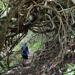
Hawaii Loa Ridge is the fight club I've been looking for: Beautiful, dirty, and it kicked my ass. _____________________________________________ THINGS TO BRING - Driver's License - Sunscreen (No need for bug spray) - Enough water for a 4-5 hour trek - Long, breathable pants if you don't like shrubbery scratching you from time to time _____________________________________________ This hike is so awesome, it's got its own bouncers. The first time I tried to get in with a group of my buddies, we were turned away because the parking lot was full. Come early to pursue this trail. It'll be easier for you to snag a parking stall plus the sun won't be burning down on you, giving you a breezier start. Hawaii Loa is a beautiful hike through and through. The motivational factor for me was seeing what awesome sight was lurking right around the corner. As other reviewers have said, the terrain starts out quiet and is a nice warm up for things to come. I was even able to run through some parts of the trail. Eventually, things start to get steeper when you enter a majestic patch of woods. It's a beautiful place to be alone in. It's the kind of place you'd expect dwarves, elves, and Elijah Wood to dwell in. After coming out of the woods, you'll start to make your way to the steeper parts of the trail and that's when shit gets real for you. There's a bit of rope climbing and the trail gets a little slippery and narrow. If you're a novice, you'll probably fight your way to the top. It's not easy, but as the fictional Bob Kelso once said, "Nothing in this world that's worth having comes easy." You're given a beautiful sight for all your efforts. Trust me on this. Though access is limited, the area at the end is small and can get crowded. Seeing so many people was a slight buzz kill at first, especially having to endure a chatty group of folks who sounded like they were auditioning for Laguna Beach. But, if I've learned anything about hiking in Hawaii, it's that you've got to share the aina with folks. So I waited for those guys to head out and eventually I got the spot all to myself for half an hour. It was a perfect place to have lunch. Overall, it took me about 5 hours, but that's including breaks where I was taking pictures and going "Oooh! Look at that! That's fucking beautiful!" It's a definite must-try and a good place to bring active friends from the mainland if you want to give them a good view of the entire island. read more


6 years ago
I have done this hike multiple times in all different type of weather conditions! This hike most of the time has been very dry and pleasing to walk through but occasionally it is very wet and almost impossible to get through. Choose the right day to go and it is a pure blast to hike! It took me and my sons about 3 hours to get up and down this hike with a short break at the top of the hike. The last part of the hike is pretty steep so be ready to climb some ropes! Other than that it is a gradual climb full of amazing views, some of which I showed my photos for! There isn't much parking at the top so this means the hike is often almost nearly empty which is just perfect for my loud boys haha! read more


You need a Hawaii state ID to access the trailhead for this hike. Driving east on Kalanianaole Hwy, turn right at Jughandle turnoff, to cross over to Pu`u`ikena Drive (no left turn on hwy). You have to show your Hawaii ID at the guard gate. They only allow about 10 cars at a time, so if you're not early enough (or late enough, after people have already left) you won't get in. If you manage to get past this stage, you're in for a great hike. Drive up about 1.5 miles to the parking spaces, and start the hike near the water tower. It's not too challenging a hike - except for the last part, which is pretty steep. There are some ropes to hold on to on the steeper parts, as well as plastic slat-reinforced steps. Total elevation gain, hiking, is about 1700ft (total~2300ft above sea). I hiked this trail when it was dry, but I can imagine the challenge increasing exponentially if the ground is muddy. Cloud cover (or lack of) permitting, the ridge summit offers great views overlooking windward Oahu, from Kailua to Waimanalo. Luckily for us, the weather cooperated, and we had a clear view - this was my 3rd summit hike, and the first time I'd seen an unobstructed view from there. I was really glad that the clouds weren't covering everything, especially since that's how it appeared when we started the hike. About 1 hr 45 mins to top, and another 90mins back. Bring plenty of water - I drank about 3 liters from my camelback... The only reason I'm not giving this 5 stars is because of the hassle of dealing with the security check, and the fact that I had tried once before, but didn't get access because they already filled their quota. There are similar ridge hikes that offer comparable views, Kuliouou, and read more

11 years ago
Out of the three side by side ridge hikes in Hawaii Kai (Hawaii Loa, Wiliwili Nui, and Kuliouou), Hawaii Loa is my least favorite - still a great cardio-driven hike. Hawaii Loa has some natural drawbacks; the trailhead is at the top of a posh gated community...there are only 10 parking passes at the top. Security officers are friendly, but don't think about being an ass and making up some crap like you're visiting someone in the neighborhood...on a typical Saturday or Sunday, prepare to get their by 8 am, or most likely you won't get a pass. The hike itself starts out fairly easy...no extreme inclines, until about 3/4 way through and you'll encounter a bunch of stairs and a couple middy slopes with just a rope...nothing dangerous or too difficult; but I'd say it's an easy to moderate level hike (simply because it may be a little more challenging for small kids; not impossible though). The hike itself is naturally well maintained, with the trailhead situated in a lovely private park. There are benches and a pull up mini gym there, perfect to hang out and eat lunch or breakfast before the hike. While the hike itself is pretty with nice lookback views on the way up, the view at the top is poor...the vegetation isn't maintained at the top for some reason, and is overgrown obstructing the majority of the diamond head side views... Otherwise, a great hike that you should make time for. read more


Lately my mission has been to do trails in Koolau's and Hawaii Loa Ridge had been on my list. I was worried that we wouldn't be able to park since they have a 10 car limit but we went around 1 pm and it turned out to be the perfect time because the guard told us that many of the other people had just left. Make sure that the person driving has his/her Hawaii license. Everyone will also have to sign a waiver. The trail is well maintained and it looked like they were in the process of installing the steps in the last section which is always reassuring. I would rate this trail intermediate. Harder than Mariners Ridge and easier than Lanipo or Ka'au Crater. There are no real "dangerous" (narrow) spots like on Lanipo or Ka'au Crater. The trail was very similar to Lanipo in some sections. You start the trail at a high elevation so you'll see a beautiful view 5 minutes into the hike. You'll also have the chance to see the LOTR like trees and grassy areas. This always makes for some awesome pictures. The last section is steps and ropes. Its probably the most difficult spot because it seems a little never-ending at first but don't worry you'll reach the top and remember how lucky you are to live in Hawaii. The view is unreal like all the other Koolau trails and you'll get to see a 360 view of Kaneohe Bay, Honolulu, Koko Head, and Olomana. It took us about 4 hours round trip which was actually a fairly short hike from what I've been used to lately. Its a nice morning or afternoon hike but it definitely won't take you all day. YELP 365: 120/365 read more


7 years ago
Awesome. Longer than expected. Like others said, get here early Bc they only allow a certain number of cars in to this gorgeous gated community. I brought my blind pup and my other dog, and they had a blast. Easy but long. Beautiful views. Wild absolutely recommend. read more


10 years ago
Been getting into hiking lately. I recently moved to Hawaii Loa Ridge and everyone told me it's a must to do the Hawaii Loa Trail. I must say this is by far the most beautiful hikes ever The hike is about 2 1/2 hours to the other side where you can see the the north scenery. 4-5 hours total. The scenery is stunning. The trail isn't so bad either, as a beginner I find it challenging yet fun because there's always something different every 15-20 minutes. However, it can be dangerous so make sure you go with an experienced hiker and go only on a nice sunny day. I don't recommend going during night or on a windy/rainy day... Happy hiking! :) read more


11 years ago
I would consider this hike to be for intermediate hikers and above. Hiking shoes are highly recommended, and lots of water is a necessity. It can also get very muddy after a rain, so plan accordingly. It took us 75 minutes to get to the top and 60 minutes to get down, with only short breaks for pictures and water. We got to the security gate on Puuikena street around 1015 on a Friday. There were still 2 visitor parking spaces available for hikers at this time. As others have said, make sure the driver has a valid Hawaii ID. We got to the hiking parking lot around 1030 and started the trail shortly thereafter. The trail was pretty easy at first. It goes through some dirt and rock portions with views of the valley and then through a forest section. Next came a portion known as "a walk in the park", and it's named so ironically as this is the first pretty significant inclined portion. DEFINTIELY not a walk through the park. After about an hour of the "easy" portion of the hike, we made it the stairs. Similar to Kuiliouou, the stairs are the last portion of the hike and also the most strenuous. There are about 400 steps up to the end of the trail. This is the "mini kokohead" portion of the hike, and it's definitely a workout. We were sweating pretty good by the time we made it up. We got to the top of the stairs in about 15 minutes with only a few stops. The view was definitely worth it! You can see all the way from town around to Hawaii Kai and then to kailua. Read the tips from others and be aware of the weather. Enjoy! read more

12 years ago
One word - cardio! It's a great work out as I always want to look for a hike that'll make me sweat. The higher you get, the nicer the view behind you of diamond head, Waikiki, and town get. Personally, the view at the viewpoint was kind of anticlimactic - but again, the views behind and of the mountains you've just conquered and the ones besides you make up for it. Definitely recommend the hike. Just be clean and don't be a disturbance to the gated community and hopefully this hike will be open to the public for all the years to come! read more


What's better than a free hike, fresh air and plenty of laughter and positive vibe. Saturday morning hike on Hawaii Loa Ridge trail. Sign in at the guard station with your drivers license and drive all the way to the ridge top where there are about 10 guest parking stalls. Cost is no charge. You get a good workout, talk story with your favorite lender and catch up with the market and escrow. Three hours of work. We got all muddy but it was fun. Can't wait for the next one. read more


Apparently, I live on the same road to this trail but didn't know until my coworker told me. I felt dumb. You will need to come early to secure parking spaces for this trail. I believe there are only 8 slots available and security guard will turn you down if they're all filled. Security guard? Yes, because you will drive through what may be most wealthy neighborhood of Oahu. Houses on Puuikena Drive are all multi-million dollars and will make you wonder what these people do for living. I believe you must hand Hawaii license or state ID to enter, so if your tourists, this is a bad news. Tourists shouldn't spend half day hiking this anyway, go other more touristy hiking trails (Diamond Head, Manoa Falls, Koko Head). Hiking should take about 4 hours for people with right gears and in shape. We had terrible weather when we hiked - the visibility was bad, the trails were muddy and VERY slippery. This made the trail extremely difficult and dangerous. I felt about 14 times and thought was doing mud race. Seriously. The first half of the trail is easy, not so much of uphill battle. However, toward the end of hike, you will go through ropes, big stairs, and narrow roads. Don't look down if you're scared of heights (I am), your legs will start shake and eventually make things more worse. It was extremely foggy when we hiked, so even if I wanted to see bottom, I saw nothing. When we got to the top, we saw nothing. My shirts and shorts are completely muddy and rewards were emtpy. Supposedly, I am to see great view of Waimanalo and its Windward towns. There are many hiking trails nearby and offer similar views and difficulties. If you can't get through security guards, try Mariner's Ridge. read more


8 years ago
Nice place to park up top. But only ten slots. Make sure you have ID to get though the security gate. Military or Hawaii ID required. The hike was a lot harder than I expected. The trail is well maintained so you can see exactly where you're supposed to go. I don't mind the slippery roots or the mud on my shoes. I dont mind that I had to climb some very narrow ridges and up a bunch of stairs because to me that's all part of the adventure. It's worth the amazing views and getting to stand in the clouds when you get to the top! Take lots of water!! read more


Page 1 of 3
More info about Hawaii Loa Ridge Trail
Puuikena Dr
Honolulu, HI 96821
Directions
Hours
Indoor Amenities
Outdoor Amenities
Hawaii Loa Ridge Trail Reviews in Other Languages
Ask the Community - Hawaii Loa Ridge Trail
Review Highlights - Hawaii Loa Ridge Trail
You might also consider


Why does Yelp recommend reviews?
Hawaii Loa Ridge Trail - hiking - Updated July 2026
Best of Honolulu
People found Hawaii Loa Ridge Trail by searching for…
Hiking Trails in Honolulu, Hawaii
Scenic Night View in Honolulu, Hawaii
Things to Do in Honolulu, Hawaii
Hiking Club in Honolulu, Hawaii
Flower Fields in Honolulu, Hawaii
Rope Swing in Honolulu, Hawaii
View Points in Honolulu, Hawaii
Dog Friendly Beaches in Honolulu, Hawaii
Night Hike in Honolulu, Hawaii
Full Moon Hike in Honolulu, Hawaii
Stair Climbing in Honolulu, Hawaii
Abandoned Places in Honolulu, Hawaii
Dog Friendly Hiking Trails in Honolulu, Hawaii
Dog Friendly Things to Do in Honolulu, Hawaii
Sunrise View in Honolulu, Hawaii
Scenic Overlook in Honolulu, Hawaii
Lakes & Ponds in Honolulu, Hawaii
Running Routes in Honolulu, Hawaii
Easy Hikes in Honolulu, Hawaii
Waterfall Hike in Honolulu, Hawaii
Walking Trails in Honolulu, Hawaii
Trending Searches in Honolulu, HI
4th Of July Fireworks near Hawaii Loa Ridge Trail
Boat Rental near Hawaii Loa Ridge Trail
Cliff Jumping near Hawaii Loa Ridge Trail
Day Trips near Hawaii Loa Ridge Trail
Dog Friendly Trails near Hawaii Loa Ridge Trail
Fireworks near Hawaii Loa Ridge Trail
Jet Ski Rental near Hawaii Loa Ridge Trail
Kayak Rental near Hawaii Loa Ridge Trail
Lakes & Ponds near Hawaii Loa Ridge Trail
Outdoor Activities near Hawaii Loa Ridge Trail
Parks For Picnics near Hawaii Loa Ridge Trail
Places To Walk Around near Hawaii Loa Ridge Trail
Public Pools near Hawaii Loa Ridge Trail
Public Shower near Hawaii Loa Ridge Trail
River Swimming near Hawaii Loa Ridge Trail
Rock Quarry near Hawaii Loa Ridge Trail
Scenic Night View near Hawaii Loa Ridge Trail
Scenic Overlook near Hawaii Loa Ridge Trail
Secluded Spots near Hawaii Loa Ridge Trail
Soccer Store near Hawaii Loa Ridge Trail
Splash Pad near Hawaii Loa Ridge Trail
Strawberry Picking near Hawaii Loa Ridge Trail
Sunrise View near Hawaii Loa Ridge Trail
Swimming Holes near Hawaii Loa Ridge Trail
Swimming Lakes near Hawaii Loa Ridge Trail
U Pick Farms near Hawaii Loa Ridge Trail
Watch Sunset near Hawaii Loa Ridge Trail
Browse Articles
Browse Nearby
BEST of Honolulu, Hawaii Coffee near Hawaii Loa Ridge Trail
BEST of Honolulu, Hawaii Restaurants near Hawaii Loa Ridge Trail
BEST of Honolulu, Hawaii Things to Do near Hawaii Loa Ridge Trail
BEST of Honolulu, Hawaii Breakfast near Hawaii Loa Ridge Trail
BEST of Honolulu, Hawaii Parks near Hawaii Loa Ridge Trail
BEST of Honolulu, Hawaii Walking Trails near Hawaii Loa Ridge Trail
BEST of Honolulu, Hawaii Campgrounds near Hawaii Loa Ridge Trail
BEST of Honolulu, Hawaii Sightseeing near Hawaii Loa Ridge Trail
BEST of Honolulu, Hawaii Airport near Hawaii Loa Ridge Trail
Browse Brands
Related Searches in Honolulu, HI
Affordable Kayak Rental Services in Honolulu, Hawaii
Best Fishing Locations and Guides in Honolulu, Hawaii
Best Nature Trails for Hiking in Honolulu, Hawaii
Best Places for Horseback Riding in Honolulu, Hawaii
Best Waterfalls and Swimming Holes in Honolulu, Hawaii
Check Out Off Road Trails in Honolulu, Hawaii
Discover Dog Friendly Trails to Explore in Honolulu, Hawaii
Discover Kid Friendly Hiking Trails in Honolulu, Hawaii
Discover Scenic Hiking Trails in Honolulu, Hawaii
Discover Scenic Waterfall Spots in Honolulu, Hawaii
Discover Walking Parks in Honolulu, Hawaii Near You
Discover a Hiking Trail in Honolulu, Hawaii
Discover the Best Night Hike Trails in Honolulu, Hawaii
Dog-Friendly Hikes With Dogs in Honolulu, Hawaii
Enjoy Camping Adventures Around Honolulu, Hawaii
Enjoy Kayaking Adventures in Honolulu, Hawaii
Enjoy Tent Camping Spots Around Honolulu, Hawaii
Enjoy a Beautiful Waterfall Hike in Honolulu, Hawaii
Enjoy a Peaceful Nature Walk in Honolulu, Hawaii
Enjoy the Best Picnic Spots and Ideas in Honolulu, Hawaii
Enjoy the Best Walking Path in Honolulu, Hawaii
Enjoy the Best Walking Trails in Honolulu, Hawaii
Exciting Cliff Jumping Spots in Honolulu, Hawaii
Explore Beautiful Parks and Green Spaces in Honolulu, Hawaii
Explore Easy Hikes Perfect for All in Honolulu, Hawaii
Explore Fun Activities to Do in Honolulu, Hawaii
Explore Popular Campgrounds Near Honolulu, Hawaii
Explore the Best Beach Spots in Honolulu, Hawaii
Explore the Best Swimming Holes Around Honolulu, Hawaii
Explore the Best Trail Options in Honolulu, Hawaii
Family Friendly Hiking With Kids in Honolulu, Hawaii
Find Popular Ziplining Spots Around Honolulu, Hawaii
Find the Best Parks for Picnics in Honolulu, Hawaii
Find the Best Scenic View Locations in Honolulu, Hawaii
Great Places to Walk in Honolulu, Hawaii
Hike the Popular Waterfall Trail in Honolulu, Hawaii
Hiking Trails With Waterfalls in Honolulu, Hawaii
Off Leash Dog Hiking Trails in Honolulu, Hawaii
Plan a Scenic Drive Route Near Honolulu, Hawaii
Popular Outdoor Activities to Try in Honolulu, Hawaii
Popular Picnic Spots to Visit in Honolulu, Hawaii
Safe River Swimming Areas in Honolulu, Hawaii
Safe and Fun Parks for Kids in Honolulu, Hawaii
Top Climbing Spots and Gyms in Honolulu, Hawaii
Top Paddleboarding Activities in Honolulu, Hawaii
Top Places for Snorkeling in Honolulu, Hawaii
Top Running Trails to Explore in Honolulu, Hawaii
Top Swimming Spots and Pools in Honolulu, Hawaii
People who viewed Hawaii Loa Ridge Trail also viewed
Kuliouou Ridge Trail
410 reviews
Wiliwilinui Ridge Trail
159 reviews
Mount Olympus via Kolowalu
27 reviews
Manoa
Mo'ole Valley
5 reviews
Kulepeamoa Ridge Hike
9 reviews
Niu Valley
Koko Crater Trail
918 reviews
Hawaii Kai
Moanalua Valley Trail
69 reviews
Kanealole Trail
8 reviews
Moleka Trail
3 reviews
Friendship Garden
74 reviews