Holbert Trailhead Photos


You might also consider


More like Holbert Trailhead
Recommended Reviews - Holbert Trailhead
Start your review...


Reviews With Photos

A "moderately challenging" trail that can be done in under 2 hours! Holbert trail is my most-travelled trail (I've gone at least 5 times in 2025). Doesn't matter the time of day, or day of the week, you're bound to find other hikers on the first half of the trail (at least through where it leads to Dobbins Lookout). And once you get to the trailhead, you can take other nearby trails like National Trail -- which spans over 14 miles!


This trail is okay. Compared to other hikes I've done in Phoenix, this one was the least rewarding in terms of scenic landscape. The trail is pretty easy and you can see the city from the lookout. On the day I went there were lots of people blaring their music on this trail and Dobbins Lookout was occupied by a group that drove up there to exercise inside the structure. Underwhelming compared to Tom's Thumb or Peralta trail, but great if you are looking for some exercise close to the city
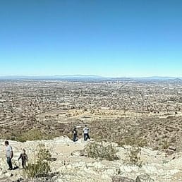

I have to start out by saying, I LOVED THIS HIKE! Do. It. Now. Here are the facts: 1100 feet elevation change, difficult rating, 2.5 miles one way, 5 miles round trip. To put it in perspective, it is actually less of a climb than Camelback Mountain but a longer distance; which I LOVE! The scenery at the top is gorgeous and there is a cool rock house to relax in the shade, enjoy a snack, and take a quick break before heading back down. There were people of all ages doing this hike and even our 10 year old sheepie made the trek! It was a gorgeous day when we hiked and I felt like I had the best workout when we were finished. I have never done any of the South Mountain hikes but I can definitely say that we'll be back! :) There is also a TON of parking and bathrooms at the bottom, which is so great!


This trail was so fun! My family and I stumbled along this trail when looking for hiking during our trip to Phoenix. It was a great moderate climb as the first half of the trip was completely up hill and then you come back down on the second half. Even though it was uphill for the first half I did not feel that it was too hard. We saw many young families doing and completing this trail. The only thing that I would be cautious with if your wanting to do this with younger kids, is the trail does have a lot of rocks so you have to really watch your footing. The trial also is on the edge of a steep hill for most of the climb. There is a lookout point about half way up the trial as well. At the top you get to Dobbins Lookout. It was very cool to see above the city. I absolutely loved this trail (about 4.5 miles overall or 2.25 each way)
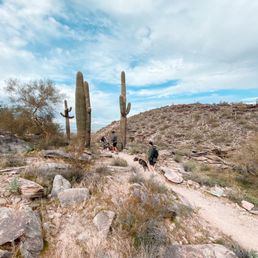

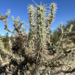
Best. Trail. Ever!! It's hard finding a nature trail that both offers a challenging and great views, but Holbert Trailhead did not disappoint! Firstly, bring lots of water! It gets pretty hot on the trail, so be sure to hydrate. Secondly, bring sunscreen, because like I said: HOT! I put on 70 spf sunscreen and still got a mild sunburn ): this trail is pet friendly, but please keep them on a leash. While hiking with our fur babies we encountered not one, not two, but a whole family of coyotes. Majestic as they are, we were pretty scared to see them crossing right in front of us! The climb up is about 1000ft in elevation, but this would be an easy hike compared to Tom's Thumb since the climb is gradual rather than a continuous steep upward climb. If you don't feel like hiking, there's a drive up to Dobbin's peak where the view is spectacular! We also saw lots of cacti along the way and met some amazing people. Follow the trail markers, because it is easy to get lost! At one point we didn't see any trail markers and ended up going the wrong way, but as long as you end up at the top, it's worth it!


Not sure if I should be reviewing this listing or the one for the South Mountain Activity Complex, but I'll do this one since I came here for the Holbert trail. I've been here a handful of times, but not too often since it's pretty far from home. I was planning to stop by a local coffee shop in this area, so I decided to do an early morning hike beforehand. It's pretty easy to get to this trailhead, and their hours year-round are 5am - 11pm (gates open and close). I wish they would open a bit earlier during the summer, but I got there a few minutes after 5 anyways. I'm always surprised at how few people/cars I see in the lot, I anticipate it being busier. They recently completely construction here and there's a beautiful pavilion now. Several restrooms and water fountains, which is great. Last time I came here, they had rerouted the beginning of the trail to the northernmost part of the parking lot, so that's where I thought it would be. Took me a few minutes to orient myself from the map because I didn't realize there were multiple bathrooms. Holbert trail is nice and there are a few switchbacks before connecting to Dobbins Lookout, which can be reached by car and has a parking lot. I decided to make the small detour to the lookout and spend a few minutes walking around; I like the little house they have. I really didn't like all the trash I saw lying around; I picked up a few napkins, straws and bottles. Not sure if it's flying out of the trash cans or people just being lazy, but it made me sad. I continued on the trail to the National trail, and made it a loop by connecting to the Kiwanis trail and finally Las Lomitas back to the trailhead. I ran into maybe a dozen people, tops. There are so many parking spots available here and the only time I've seen it full is when I did the Phoenix Summit Challenge in November last year. There are probably other times when it gets busy, like when there are events and such, but usually it's so empty. Maybe because it's the hottest part of the summer. This is one of the trailheads that will close from 8am - 5pm when there is an extreme heat warning from the National Weather Service, so be aware of that. I do want to explore the National trail more, so I plan to be back. read more


On a Saturday afternoon, I checked out Holbert Trailhead at South Mountain Park. Finding the trail isn't super easy as it's a bit hidden but here are instructions on how to get there: enter the park and follow the signs that point you to the visitor's center. After passing by the visitor's center, follow the road until you hit an area under construction. The road will make you turn left and then it will bring you into the parking lot. In the corner of the parking lot by the construction, you'll find the entrance to the trail. Now that we've gotten that out of the way, let's get to the good stuff. Holbert Trailhead is listed as a "moderate difficulty" trail on AllTrails. By the way, if you don't use AllTrails, I highly recommend that you download the app. It keeps track of where you're at on a trail (to make sure you stay on track) and also keeps track of some cool stats for you like the amount of time you've spent on the trails, the number of miles you've hiked, the elevation, etc. Rating Holbert as a moderate trail is fair. The first half of the hike is at an incline as you're scaling the mountain. You'll come across a lot of uneven rocks so it's not easy. Make sure to bring plenty of water. You'll eventually reach a fork where one path will continue on Holbert and the other will take you to Dobbins Lookout. Take the path on the right to get to Dobbins Lookout which is one of the most spectacular nature views in Phoenix. To get to Dobbins, depending on your pace, it will take you about an hour and a half. Once you arrive, you'll be rewarded with spectacular views of Phoenix and surrounding suburbs. And you'll have the satisfaction of knowing that you walked there instead of driving there like a bunch of other people you'll see at Dobbins. From there, you'll return along the same path to get to the beginning of the trail again. The return trip will be quicker as you're going on a decline. It will be harder on your knees and you'll have to be careful with your footing, but it will be less strenuous. All in all, it should take you anywhere between two and a half to three and a half hours depending on how long you chill at Dobbins. All in all, a top hike! read more


4 months ago
Good trail to see downtown from afar, has good views. Is a winding trail, can be sandy, rocky, and inclines. Bring water, hat, and good hiking shoes. Follow the signs and start from the new South Mountain Activity Center. read more


A "moderately challenging" trail that can be done in under 2 hours! Holbert trail is my most-travelled trail (I've gone at least 5 times in 2025). Doesn't matter the time of day, or day of the week, you're bound to find other hikers on the first half of the trail (at least through where it leads to Dobbins Lookout). And once you get to the trailhead, you can take other nearby trails like National Trail -- which spans over 14 miles! read more


2 years ago

This trail is okay. Compared to other hikes I've done in Phoenix, this one was the least rewarding in terms of scenic landscape. The trail is pretty easy and you can see the city from the lookout. On the day I went there were lots of people blaring their music on this trail and Dobbins Lookout was occupied by a group that drove up there to exercise inside the structure. Underwhelming compared to Tom's Thumb or Peralta trail, but great if you are looking for some exercise close to the city read more


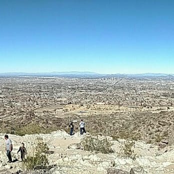
I have to start out by saying, I LOVED THIS HIKE! Do. It. Now. Here are the facts: 1100 feet elevation change, difficult rating, 2.5 miles one way, 5 miles round trip. To put it in perspective, it is actually less of a climb than Camelback Mountain but a longer distance; which I LOVE! The scenery at the top is gorgeous and there is a cool rock house to relax in the shade, enjoy a snack, and take a quick break before heading back down. There were people of all ages doing this hike and even our 10 year old sheepie made the trek! It was a gorgeous day when we hiked and I felt like I had the best workout when we were finished. I have never done any of the South Mountain hikes but I can definitely say that we'll be back! :) There is also a TON of parking and bathrooms at the bottom, which is so great! read more

5 years ago
This trail was so fun! My family and I stumbled along this trail when looking for hiking during our trip to Phoenix. It was a great moderate climb as the first half of the trip was completely up hill and then you come back down on the second half. Even though it was uphill for the first half I did not feel that it was too hard. We saw many young families doing and completing this trail. The only thing that I would be cautious with if your wanting to do this with younger kids, is the trail does have a lot of rocks so you have to really watch your footing. The trial also is on the edge of a steep hill for most of the climb. There is a lookout point about half way up the trial as well. At the top you get to Dobbins Lookout. It was very cool to see above the city. I absolutely loved this trail (about 4.5 miles overall or 2.25 each way) read more


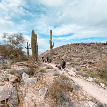
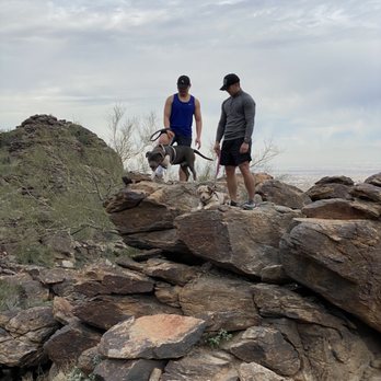
Best. Trail. Ever!! It's hard finding a nature trail that both offers a challenging and great views, but Holbert Trailhead did not disappoint! Firstly, bring lots of water! It gets pretty hot on the trail, so be sure to hydrate. Secondly, bring sunscreen, because like I said: HOT! I put on 70 spf sunscreen and still got a mild sunburn ): this trail is pet friendly, but please keep them on a leash. While hiking with our fur babies we encountered not one, not two, but a whole family of coyotes. Majestic as they are, we were pretty scared to see them crossing right in front of us! The climb up is about 1000ft in elevation, but this would be an easy hike compared to Tom's Thumb since the climb is gradual rather than a continuous steep upward climb. If you don't feel like hiking, there's a drive up to Dobbin's peak where the view is spectacular! We also saw lots of cacti along the way and met some amazing people. Follow the trail markers, because it is easy to get lost! At one point we didn't see any trail markers and ended up going the wrong way, but as long as you end up at the top, it's worth it! read more


7 years ago

7 years ago
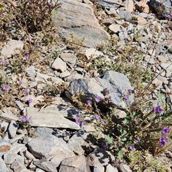
Great trail that offers some level walking along with steep hiking. It is a great trail for beginners to just do the first half and then work your way up to the really steep hills. Scenery is great when you get to the top. If you go all the way to the top, the view is beautiful. I attached a picture of the less elevated stopping point. read more


More info about Holbert Trailhead
Ask the Community - Holbert Trailhead
Review Highlights - Holbert Trailhead
You might also consider






























Why does Yelp recommend reviews?
2 reviews that are not currently recommended
The reviews below are not factored into the business's overall star rating.

1 year ago
10 years ago
Holbert Trailhead - hiking - Updated August 2026
Best of Phoenix
People found Holbert Trailhead by searching for…
Hiking Trails With Waterfalls in Phoenix, AZ
Easy Hiking Trails in Phoenix, AZ
Hiking With Kids in Phoenix, AZ
Dog Friendly Hiking Trails in Phoenix, AZ
Places to Take Pictures in Phoenix, AZ
Dog Friendly Things to Do in Phoenix, AZ
Mountain Bike Trails in Phoenix, AZ
Free Things to Do in Phoenix, AZ
Trending Searches in Phoenix, AZ
Barbers near Holbert Trailhead
Bike Shop near Holbert Trailhead
Cliff Jumping near Holbert Trailhead
Consignment Shops near Holbert Trailhead
Cruising Spots near Holbert Trailhead
Dog Friendly Things To Do near Holbert Trailhead
Ear Piercing near Holbert Trailhead
Eyebrow Threading near Holbert Trailhead
Flower Fields near Holbert Trailhead
Hair Braiding near Holbert Trailhead
Kids Haircut near Holbert Trailhead
Mini Golf near Holbert Trailhead
Pedicure near Holbert Trailhead
Permanent Makeup near Holbert Trailhead
Picnic Areas near Holbert Trailhead
Preschools near Holbert Trailhead
Public Golf Courses near Holbert Trailhead
Rock Quarry near Holbert Trailhead
Running Trails near Holbert Trailhead
Scenic Night View near Holbert Trailhead
Scenic Overlook near Holbert Trailhead
Sunrise View near Holbert Trailhead
Swimming Holes near Holbert Trailhead
Trading Card Shops near Holbert Trailhead
Uniforms near Holbert Trailhead
Used Furniture Stores near Holbert Trailhead
Browse Articles
Browse Nearby
BEST of Phoenix, Arizona Restaurants near Holbert Trailhead
BEST of Phoenix, Arizona Coffee near Holbert Trailhead
BEST of Phoenix, Arizona Things to Do near Holbert Trailhead
BEST of Phoenix, Arizona Parks near Holbert Trailhead
BEST of Phoenix, Arizona Breakfast near Holbert Trailhead
BEST of Phoenix, Arizona Horseback Riding near Holbert Trailhead
Browse Brands
Related Searches in Phoenix, AZ
Affordable Kayak Rental Services in Phoenix, Arizona
Best Dog Hiking Trails Around Phoenix, Arizona
Best Fishing Locations and Guides in Phoenix, Arizona
Best Nature Trails for Hiking in Phoenix, Arizona
Best Places for Horseback Riding in Phoenix, Arizona
Best Sightseeing Experiences Available in Phoenix, Arizona
Check Out Off Road Trails in Phoenix, Arizona
Discover Dog Friendly Trails to Explore in Phoenix, Arizona
Discover Easy Hiking Trails Near Phoenix, Arizona
Discover Kid Friendly Hiking Trails in Phoenix, Arizona
Discover Popular Bike Trails in Phoenix, Arizona
Discover Scenic Mountain Bike Trails Near Phoenix, Arizona
Discover Walking Parks in Phoenix, Arizona Near You
Discover a Hiking Trail in Phoenix, Arizona
Discover the Best Night Hike Trails in Phoenix, Arizona
Dog-Friendly Hikes With Dogs in Phoenix, Arizona
Enjoy Camping Adventures Around Phoenix, Arizona
Enjoy Kayaking Adventures in Phoenix, Arizona
Enjoy Off Leash Dog Hikes in Phoenix, Arizona
Enjoy Scenic Places to Walk in Phoenix, Arizona
Enjoy Tent Camping Spots Around Phoenix, Arizona
Enjoy a Beautiful Waterfall Hike in Phoenix, Arizona
Enjoy the Best Walking Path in Phoenix, Arizona
Enjoy the Best Walking Trails in Phoenix, Arizona
Explore Beautiful Parks and Green Spaces in Phoenix, Arizona
Explore Easy Hikes Perfect for All in Phoenix, Arizona
Explore Fun Activities to Do in Phoenix, Arizona
Explore Popular Campgrounds Near Phoenix, Arizona
Explore Top Dog Parks in Phoenix, Arizona Near You
Family Friendly Hiking With Kids in Phoenix, Arizona
Find Cozy Camping Cabins in Phoenix, Arizona
Find Top-Rated Waterfalls in Phoenix, Arizona Now
Find the Best Parks for Picnics in Phoenix, Arizona
Hiking Trails With Waterfalls in Phoenix, Arizona
Off Leash Dog Hiking Trails in Phoenix, Arizona
Perfect Spots to Watch Sunset in Phoenix, Arizona
Plan a Scenic Drive Route Near Phoenix, Arizona
Popular Outdoor Activities to Try in Phoenix, Arizona
Popular Picnic Spots to Visit in Phoenix, Arizona
Popular Waterfall Hiking Trails in Phoenix, Arizona
Safe and Fun Parks for Kids in Phoenix, Arizona
Top Hiking Trails to Explore in Phoenix, Arizona
Top Playgrounds for Kids to Enjoy in Phoenix, Arizona
Top Running Trails to Explore in Phoenix, Arizona
Top Swimming Lakes to Enjoy in Phoenix, Arizona
Top Swimming Spots and Pools in Phoenix, Arizona
Top-Rated Camping Sites in Phoenix, Arizona


