1. Homestead Ranch Park

    1. Homestead Ranch Park

    0

    Peyton, CO

    Cancel

    Open app

    Search

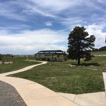
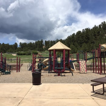
    Homestead Ranch Park

    4.8 (5 reviews)
    Open 5:00 am - 9:00 pm

    Homestead Ranch Park Photos

    Recommended Reviews - Homestead Ranch Park

    Your trust is our priority, so businesses can't pay to alter or remove their reviews. Learn more about reviews.
    Yelp app icon
    Browse more easily on the app
    Review Feed Illustration
    Photo of Mike G.
    582
    1149
    3819

    2 years ago

    Helpful 1
    Thanks 1
    Love this 0
    Oh no 0
    Photo of Mary S.
    0
    12
    10

    6 years ago

    Helpful 0
    Thanks 0
    Love this 0
    Oh no 0

    6 years ago

    Helpful 0
    Thanks 0
    Love this 0
    Oh no 0

    4 years ago

    Great park nearby and nice hiking trails! Love taking our dog on walks. Very peaceful!

    Helpful 0
    Thanks 0
    Love this 0
    Oh no 0

    10 years ago

    Helpful 1
    Thanks 0
    Love this 1
    Oh no 0

    Ask the Community - Homestead Ranch Park
    Stanley Canyon Trail

    Stanley Canyon Trail

    4.2
    (6 reviews)
    17.4 mi

    I feel this route needs a solid review from someone who is mathematically, grammatically and…read morealpinistically (I just made that up), "inclined". First of all, this is probably the most beautiful yet somewhat challenging short hike in town. If you want a snapshot of the grandeur awaiting you beyond the I25 corridor (and cell phone range) this is it! Absolutely beautiful. The short: for the average person of moderate or lacking fitness level, it should absolutely be doable. I would say the normal person could knock it out in less than 4 hours (with picture/selfie taking along the way and up top). Decent fitness levels should be up and down in less than 2 hours... Don't bring the cat-dog looking micro mutt as you will either be carrying it or burying it somewhere about the first hour of hiking. There is water throughout the trail so regular dogs should have a blast here. There is an issue with dog poo littering the parking lot and trails (despite free poo bags being offered at trail head... This hike is no joke. Wear proper shoes with decent traction. You can get hurt here! I would bring at least a liter (Nalgene bottle) of water during hot days. Although covered with trees throughout, the sun will beat down on you throughout the hike. I only say this because I passed a family of 5 about half way with no water. As far as short local hikes go, Stanley Canyon gets a Five from me. Awesome!

    This hike is not for the faint of heart. It's a pretty steep hike up and coming back down can be…read morevery difficult if you have bad knees or don't have excellent tread on your hiking boots. Scree for days! But it's a beautiful one and a great workout.

    Photos
    Stanley Canyon Trail
    2.2 miles (one way) of American greatness..(yes, that is the trail)

    See all

    2.2 miles (one way) of American greatness..(yes, that is the trail)
    Paint Mines Interpretive Park

    Paint Mines Interpretive Park

    4.5
    (96 reviews)
    13.4 mi

    We planned a camping weekend specifically so we could get an early start at Paint Mines. Hindsight,…read moreI would want to start a bit earlier even next time. We were on the trail at 8. Use sunscreen, wear a hat and bring water. The trails are well marked as are the areas that they are protecting from humans. My husband and I had a great time seeing all the formations. We started from the southernmost parking lot. Either lot works as a start point. The southern lot does not have bathroom or port-a-pot. We saw antelope on the drive there. Deer while on the trail as well as many types of birds. The wildflowers were blooming here and there and some cactus had flowers. Once we got back to our vehicle, we drove around to the overlook parking lot and did that vantage point as well. Highly recommend doing this as you get such a different perspective from being down amongst the formations and then seeing more of a composite from above. It is a worthy visit and hike. Be prepared for it to get hot, quick. Hence wanting an earlier start next time. Would do again!

    I wanted to try something new and something different and it was definitely worth the wait to try…read morethis out. It's a perfect walk. The views are spectacular!! It's definitely a must try if you're in town and want to try something different!! No dogs are allowed here that's the only downfall but other than that it's really good to experience!

    Photos
    Paint Mines Interpretive Park
    Paint Mines Interpretive Park
    Paint Mines Interpretive Park

    See all

    Trail Gems Geology Tours

    Trail Gems Geology Tours

    5.0
    (3 reviews)
    23.9 mi

    We went to CO to visit family and experience the beautiful outdoors, and a Geological Hike, the…read moreVolcanic Gems Geology Hike, with Dr. Rox was our first excursion on the weekend. Dr. Rox was fantastic. Both my wife and I are teachers, and so we loved how academic the hike was as Dr. Rox would pause and explain the rock cycle, tectonic movement, or the birth of the Rocky Mountains. We were also delighted that our two teenage sons asked a bunch of questions and were obviously engaged in, not only the Geology lesson, but also the local flora and fauna. Dr. Rox answered every question, and, when she didn't know the name of a plant, she pulled out a trusty book and looked it up. She kept things light, but we definitely learned a lot as well. When we reached the end of the hike where the zeolite crystals had grown in the geodes, we climbed all over the rocks finding crystal after crystal. It was certainly an impressive site. We really loved both the scenery and our guide, and I would recommend this hike to anyone with any interested in geology. A big thanks to Dr. Rox for making our hike so fun and educational!

    The overview summary of Trail Gems encapsulates it for me: "guiding you through the incredible…read morebeauty of Colorado's wilderness." I live in Colorado, but I do not appreciate its beauty enough. I also never knew the story behind the beautiful rock formations and natural landscapes I pass by everyday. Rox provides context and explanation for a natural history of the beautiful sights of Colorado. Rox is also very organized and thoughtful, making sure we had water, snacks, and umbrellas. We got to look, touch, break, and collect all different kinds of rocks in a variety of gorgeous locations. It was fun to explore and engage in a tactile activity. In our modern world where so much of our lives are spent behind screens, this was a truly relaxing yet exciting activity and exploration tour in the outdoors. It was creative and fun. I felt like a kid again!

    Photos
    Ancient landscapes geology hike
    Ancient landscapes geology hike
    Exploring fossils
    Exploring fossils
    Trail Gems Geology Tours

    See all

    Seven Falls

    Seven Falls

    3.4
    (396 reviews)
    24.7 mi

    Seven Falls was absolutely, positively beautiful in every way. Words can't even describe it, but…read morehopefully these photos can convince you. Seven Falls started out with a semi-short shuttle ride to the actual scenery. From there, it just got more amazing. I understand how the steps could be strenuous for many, and it definitely wasn't easy, but a little stop to catch your breath is provided about midway through. I saw a couple people who didn't feel up to finishing the steps stopping at the rest point, taking some photos, and coming back down. The views were still stunning from that height. Heck, they're stunning from any height or viewpoint. There was also a little shop with delicious popsicles located before the steps. Clean bathrooms along the way as well. It all just seemed very well-thought-out. This was also partially due to the employees, who were all very helpful and pleasant. To put it simply, Seven Falls has it all-it's beautiful, clean, and unique. Amazing in every aspect, stunning from every angle. I felt immersed in the mountainscape from the first step out of that shuttle.

    Overrated. The parking is 20 minutes from the actual falls. Waited 45+ minutes for our shuttle bus…read moreto arrive in 90 degree heat. Finally the bus showed up & it was a 20 minute ride to the falls. Get off the bus, then walk up hill half a mile, then half to walk over 200 steps in order to get to the waterfalls and trails. When you're done, you have to go the opposite direction and do it all over again. They charge $5 a piece for any beverage (water, Gatorade, etc.) and $5 a piece for an ice cream bar. If you get tickets, get them in advance on the website. Afternoon tickets after 1pm are cheaper. You do not have the option to drive to the location yourself & taking the shuttle is a requirement. Overall, not worth the price for the wait and hassle.

    Photos
    Seven Falls
    Seven Falls
    Seven Falls

    See all

    St. Mary's Falls

    St. Mary's Falls

    4.7
    (11 reviews)
    29.9 mi

    We loved our hike to st marys falls. St Marys is a moderate hike around 6.5 miles and 1394 feet of…read moreelevation gain. The main road to the falls parking lot is closed and you have to take gold camp road over. This is around 3 miles of dirt. Its narrow with some pot holes and also 2 tunnels you will need to go through. A lot of the road is very narrow and really only wide enough for just one car. So be prepared for a little bit of a hairy ride. it will be the 2nd parking lot on your right. There is a fairly large parking lot, however it fills up quickly especially on a weekend. If you want to do this you will want to arrive sooner rather than later. Dogs are allowed but are supposed to be on a leash. The parking lot for saint marys is the same as for some other trails over there, seven bridges and silver cascades being 2 of them. You will have to walk around 1 1/4 miles up a dirt road until you get to the trailhead. The trail follows a creek most of the trail. It is rocky and at times a little slick with the loose rock. It is beautiful, surrounded by forest. It was very magical and lovely. it felt so nice to be out in the woods. Mountain bikes and motorcycles are also allowed to use this trail. We did not see any motorcycles but there were a few mountain bikers. And they dont necessarily signal so well beware. There is a trash can at the trail head. Be sure to PACK out what you pack in! My friend and i were picking up garbage that people had left along the trail :( There is no reason to leave your garbage. Please take it with you.

    Inadvertently found this trail while looking for a different place to hike with the pup, who is…read moreyoung and just learning how to be a good off leash hiking dog. I'm not 100% certain, but I think that you are allowed to take your dogs off leash on this trail. I certainly never saw any signs stating otherwise and out of maybe 10 dogs we saw, half were on leash and a half off. It was a beautiful hike however we were not prepared and did not have water or maybe a hiking stick for me, at least. The beginning part of the trail is a wide open fire lane, but once you get back there it's a trail with a gradual uphill climb the entire way that turns even steeper towards the end. I was definitely asking "how much longer" for the last half-hour and really regretting that I didn't have water with me as my sensitive back started to ache. On our way down as we passed other hikers, they were asking the same question about "how much longer". The gradual uphill climb the entire way can be a little much if you're not prepared for it and the journey back down to the car is much quicker since it's basically downhill the whole way. Took half the time to get down than it did to get up. The waterfall and stream were beautiful and soothing. Walking with shady tree cover much of the way and a stream next to us was a plus for the pup to get his first experience of playing in a stream. The pup definitely enjoyed himself most of all. We took this hike in early June and on our way back we got hit with a rainstorm that dropped the temperature about 20° and we were freezing and poured on by the time we got back to the car, so be prepared when coming here in the summertime!

    Photos
    Trail
    Trail
    Trail
    Trail
    At the Falls. Beautiful view

    See all

    At the Falls. Beautiful view
    Manitou Incline

    Manitou Incline

    4.7
    (366 reviews)
    26.8 mi

    Manitou Incline... Have a day!…read more This is an epic CO hike and *can be conquered by anyone with a little intestinal fortitude... It's virtually straight up (2200+ ft vertical) then 4 miles down, no filling stations, and no shade, but is an absolute blast of a hike. It takes about 1.5 hours up and about 2-3 hours down, depending on your individual fitness level. The best part are the summit views and if you go up another 200M and take the backside Barr Trail down, the views get even better. Make sure to bring tons of water, wear good hikers (there are lots of switchbacks on the way down), and put on sun screen because it's 90+ degrees with no shade on a normal CO summer day... Don't be "that guy" or "that girl" that shows up without any gear (there were a ton of those people out there, and it's completely mind boggling), because Vegas odds are 3/2 you'll be a casualty. My best advice is take a minimum of 3L of water (I took 4L and went through all them from top to bottom, granted I sweat like a Vegas hooker in a Catholic Church), take two "tough pills" before you start, and take it slow and steady up... #slowissmoothandsmoothisfast. Make it to the top, take some great mountain pics, enjoy the trek down, and go get a celebratory cold CO crafty at one of the cool bars in Manitou springs after words.

    5/5 stars?? I know, I'd have said 0/5-do not recommend, but for this:…read more If you want a serious workout, this is for you. It's been on my bucket list for a wee bit, though I'm not sure exactly why--perhaps the grueling challenge this offers, if only to challenge myself. I had no time constraints, just get to the top and back down again. I did it! I was no record-setter by any means, and I'm okay with that. Did I "train?" No. Did I acclimatize myself (being a flatlander from Kansas), yes! I brought lots of water and electrolytes and of course SNACKS, because, hello!! It's a hike and all hikes need snacks; not to mention it's grueling and your body needs the fuel. I went up to the top the first time and down Barr Trail--that is no joke either. Switchbacks and seemingly "huge" step downs--it has its own "obstacles." The sun was shining full strength so it was toasty--doable as I had a sun hoodie on, but also a tad miserable. Second time, slightly over halfway with a friend, we walked down a hundred steps to the bailout at 1300. That was absolutely fabulous! Gorgeous scenery and that day was nice and cool and foggy! Loved it! Switchbacks too, but seemingly not as bad as what the Barr Trail has. People on this trail?? Well, they're exceptionally wonderful. Everyone--EVERYONE--was supportive, encouraging and kind. People from just about everywhere. Would I do it again? Yes. When the weather is foggy and cool. Would I want to go down the 1300 step bailout, yes. The transition of trail grades is easier than on Barr Trail IMHO, but going down the Incline is sketchy--people do it, but it's steep and the recommendation is to NOT do so. It was questionable as to whether a permit was needed. I signed up--self-proclaimed rule follower that I am--only to find no one was checking anything!! So, you do you. It might be a way to have the state of CO see how many people and from where and to sign a waiver, but otherwise no one checked. I parked at a paid lot and took a free shuttle to The Incline and back--I later found out via word of mouth that there is free parking at a park nearby where the bus stops. **As an aside, I learned the day before I was planning on going that this is no joke, people have died or have been injured on this trail--please take necessary precautions for your health and wellbeing.**

    Photos
    Manitou Incline
    Manitou Incline
    Manitou Incline
    Manitou incline halfway up during sunrise.

    See all

    Manitou incline halfway up during sunrise.
    Goose Creek Trail in Lost Creek Wilderness

    Goose Creek Trail in Lost Creek Wilderness

    4.8
    (4 reviews)
    46.6 mi

    It's a tough thing to be from CO and recommend great trails. Coloradans naturally want to gatekeep…read morebeautiful secrets, but had to write a review for this incredible hiking trail (which I'm sure isn't really a secret). Took my 12 year old daughter backpacking on this trail and we had a fantastic time. There are plenty of areas to set up a tent along the creek for the first 2 miles. After that the elevation climbs and you have to wait until 4 miles or so and you aren't as close to water. There were hardly any mosquitos, but a lot of flies. The flies were relentless, and only one type seemed to bite. Some bug spray helped a little. The scenery was beautiful. Greener than a lot of spots in CO due to the creek and massive boulders everywhere. There's a lot of bird activity including humming birds. There wasn't a ton of foot traffic either. The trail is narrow but maintained. I do not suggest going on the unmaintained trail on the other side of the creek. We hiked the maintained trail in and the unmaintained trail out and there were several spots that were difficult with a 40 lb backpack on due to loose dirt and gravel. Just stay on the main trail especially if you have kids packing in. The water level was pretty low in some areas and the only fish we saw in our spot were tiny ones, so it's probably not great for anglers. The road leading there is a long dirt road and goes down to a single lane in some spots so take it slow. One driver was being very irresponsible and driving as fast as possible and taking turns quickly so as to spin out and nearly hit us! You can't see around curves and there are steep drop offs, so please drive cautiously. There's no cell service out there (AT&T), so remember the turns you made driving and landmarks like campgrounds and ranches. Beautiful spot. Would recommend.

    I did this as part of a larger loop last weekend. The trail conditions for this segment were really…read moregood. It's a long trail, but not too difficult for a reasonably in shape person. Usually, you can walk two abreast and the river crossings are not hard. Lots of nice campsites every mile or so, visible right next to the trail. Once you get away from the trailhead, firewood is plentiful. Some camp sites are right next to water, so you can filter it and you're good. Others, you may have to carry water there. We did have some wet weather, which wasn't bad if you have good raincoats. Naturally, if you go to higher elevations, the rain comes down as snow, or hail, even in June. If you're just doing Goose Creek, within the first 7-8 miles, it's super easy to follow. However, good maps are available for free from the USGS web site. We also had a good map for Lost Creek from Amazon. Not too hard to get to the trail head, although you do have to drive about 15 miles of windy dirt road. It takes about 45 minutes for that part, especially if you have to back up to let someone go the other way on one of the single lane parts.

    Photos
    Goose Creek Trail in Lost Creek Wilderness
    Goose Creek Trail in Lost Creek Wilderness
    Goose Creek Trail in Lost Creek Wilderness

    See all

    Homestead Ranch Park - hiking - Updated July 2026

    Loading...
    Loading...
    Loading...