Cancel

    Open app

    Search

    Hopeland Trails

    4.0 (1 review)

    Hopeland Trails Photos
    You might also consider

    Recommended Reviews - Hopeland Trails

    Your trust is our priority, so businesses can't pay to alter or remove their reviews. Learn more about reviews.

    Yelp app icon
    Browse more easily on the app
    Review Feed Illustration

    4 years ago

    Helpful 5
    Thanks 0
    Love this 7
    Oh no 0

    Verify this business for free

    People searched for Parks 1,128 times last month within 15 miles of this business.

    Verify this business

    Staatsburgh State Historic Site

    Staatsburgh State Historic Site

    4.6
    (18 reviews)
    0.7 mi

    6/26/26: Staatsburgh can give many of the Newport mansions a run for their money…read more On the drive up to the mansion, you'll see a beautiful sculpture of Diana the huntress. We made reservations online. Upon entry, you'll check in and pay at the gift shop in the rear of the estate. Lindsay was very helpful. Inside the gift shop, there's wonderful items for serving tea and historical books on area mansions. Our wonderful docent was Faith. She was so passionate and highly knowledgeable of all the estate decor and family history. Think Faith is one of the best docents ever! The tour group starts out in a very low-keyed way. During that time, you're learning about the history of the estate in a fun way. Out of nowhere, the Gilded Age Opulence appears. YOU'RE WOWED! Unfortunately, Staatsburgh doesn't receive the accolades like the other well known area mansions. If you're going to see one estate in the area, make it Staatsburgh!

    The Staastsburgh Estate grounds are simply beautiful, expansive and extremely well maintained. The…read morelong canopied tree-lined paved driveway winds its way up to the mansion and down to and along the Hudson River. There is a smaller unpaved road that leads to the carriage house and around to several gardens and eventually up to the front entry way of the mansion. We didn't go inside as we had spent 40 minutes walking the grounds but plan to do so on a future visit.

    Photos
    Driving up seeing Staatsburg for the first time.
    Driving up seeing Staatsburg for the first time.
    Ice Box Room.
    Ice Box Room.
    Inside.

    See all

    Inside.
    Kaaterskill Falls

    Kaaterskill Falls

    4.6
    (166 reviews)
    22.0 mi

    The falls are truly incredible…read more The trail down to the bottom of the falls, is a bit tricky. But so incredibly worth it. I would suggest not to believe the sign saying 189 steps.... it is definitely more! Take drinking water because you'll need that for sure. We went back in August and the heat was definitely there. The parking lot was pretty packed but throughout the trails people were pretty evenly spaced out. Not so much at the base of the falls themselves but there was still plenty of room to move around freely.

    One of the tallest waterfall in NY, similar height to Taughannock Falls. Physical requirement is…read moredifferent tho, Kaaterskill Falls has about 500foot of elevation change and a lot of slippery stone steps at the end, if you come here when the weather is still cold. Parking: most people park at the Laurel-House Road parking area, because it is the closest. Or you can park at Mountain Top Historical Society, the old train station, which an extra mile. Starting from the old railroad station is nice, you can still see some old tracks on the ground. Walk to the overlook is fairly easy, once you get to the start point of Lower falls junction, it is where you need to be prepared. I recommend hiking shoe, especially in colder months where the ground is wet and iced. When you reach to the stone steps, they can get slippery. I am surprised no one fell in late March. Half of the steps were cover in ice and people were wearing regular sneakers. Once you reach the base of the two tier falls, the view is tremendous. If water levels are high, you can feel the energy of the water. There is a lot of spray from the falls when you get close. There is short trail to the middle tier pool. It was iced up during winter, spikes will definitely be useful. The end was amazing too. So close to the lead of the waterfall. You can keep going and follow Escarpment trail and follow the edge of the valley. There is monument for fireman Frank Layman who died during firefighting in 1900, at his monument, you can see route 23A bend around mountain. And if you keep going, there are a couple viewpoint to overlook the valley. Nice break points to enjoy the view and rest your legs.

    Photos
    View Of Stream
    View Of Stream
    Kaaterskill Falls
    Kaaterskill Falls

    See all

    Margaret Lewis Norrie State Park

    Margaret Lewis Norrie State Park

    3.2
    (35 reviews)
    1.9 mi

    This a a fantastic area to camp in, there are SO MANY things you can do in the neighborhood…read more(Vanderbilt mansion, CIA, Roosevelt presidential library and museum, orchards and farms, walkway over the Hudson). In terms of the campground, the bathrooms and showers are great. The actual campsite are way too close together and there are these little seed pod things that get everywhere and are harmless, but kind of suck anyway.

    Well well, Norrie State Park was the first discovery for me when I was on a field trip during my…read morehigh school career when we visited the Norrie Point Environmental Center. This review is going toward the hiking me and my friend experienced, and it was a good one. We parked at the closet entrance, which is on the left. We took the blue trail which is 4.59 miles to exist (making it the longest trail). Some of the markers along the way are not clearly marked as we ended up going the wrong way, making it confusing. One of the blue markers on a tree was facing at the wrong angle. We then figured it out later on thankfully, as we saw the marker up ahead. With me being good with maps and getting around, we ended up going off the path onto the main road to the Hudson River close up. There are a couple of spaces for parking. We got back on the blue trail as it did a big loop and got on the red trail for a bit, until reaching the main road and followed that to the parking lot where we parked. There are multiple trails along the way to take in, as the white trail, according to the map follows the river, which looks appealing. That will be for another visit. To keep life simple, there should be more maps provided along with updated signage for trail colors, which will then bring up my rating.

    Photos
    Camp site 44, we had a six person tent. Short walk to the rest rooms and showers
    Camp site 44, we had a six person tent. Short walk to the rest rooms and showers
    Camp site 44
    Camp site 44
    Margaret Lewis Norrie State Park

    See all

    TR Gallo Waterfront Park

    TR Gallo Waterfront Park

    4.0
    (2 reviews)
    4.9 mi

    When you factor in just the nearest park setting, this park tends to be a little small - with few…read morebenches. But when you factor in the expansive area just outside the park - this waterfront park can be huge. It's centerpiece is it's monument dedicated to kingston members of the armed forces who've risked their lives and died - found at the corner nearest the waterfront bathrooms near the Rip Van Winkle boat. I myself have found the ability to feed the birds and ducks that go by here often. It can be so serene and these poultry know it. You can often find electric fish coming up from the water below to catch food floating on the water's surface. Then you add in the few benches that exist, and you will get a park. It's gotten worse over the years. Many years ago, there used to be live bands playing on the stages, but it seems like they've all be told to find other gigs elsewhere. A person who sits on the benches, will sometimes hear the soundtrack from what's inuse at Mariners Harbor nearby, but this isn't even the best. There's little - if any - parking existing for this park that is free. You either have to pay for sidewalk-like parking, or you can go into the lot (which often is full of cars from the Landing added to the cars from the nearby businesses), or if you see a non-handicap spot nearest the Rip Van Winkle boat (isn't often), you can take one there. Your best bet is to park somewhere else in Kingston and Uber-down to the park (or Uber to Mariners Harbor and walk). I don't come down here that often, if it isn't for some peace and quiet in busy times, but it can be a necessary place at times.

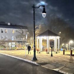
    Boats creeks and…read moreplaques T.R, Gallo Park was developed in 1984 and renovated and expanded in the years since then. Not a very large park but it is connected to a river walk so it's possible to walk for several miles along the water. The park is located on Roundout Creek and has nice views of the water and boats at the marina. You can even see a couple of very cool lighthouses if you really try. The park has a nice gazebo, picnic tables, benches and a memorial to all those brave souls that have been lost at sea. Lots of events are held at the park in the warm months and there is even a little place to launch kayaks and other small craft. Not a large park but one in a great location. A great use of the open space down by the marina and water.

    Photos
    ''Twas The Night After Christmas
    ''Twas The Night After Christmas
    Beautiful fall foliage!
    Beautiful fall foliage!
    UnderCover @ Nite: (@ The Gazebo)

    See all

    UnderCover @ Nite: (@ The Gazebo)
    Minnewaska State Park Preserve

    Minnewaska State Park Preserve

    4.5
    (169 reviews)
    19.7 mi

    Great trail maintenance, accurate mapping, crystal clear water - I was impressed. We will return.read more

    I made my Gunks debut yesterday and was pretty impressed despite the very meh weather situation…read more This is about 90 minutes from my HQ so probably right at the limit of a convenient day hike, and somehow I've never really been in this area before beyond travelling past it going up and down the NY Thruway. Definitely returning when the sun is actually out. I did the 8.7-mile Castle Point hike (my gut says it wasn't QUITE that long, but I don't want to argue with my book) from the Awosting parking lot down the Mossy Glen Trail (yellow blazes), making a left onto and up Blueberry Run (blue) to Castle Point itself, and then went basically straight down the cliff on the Scenic Trail (lavenderish and formerly light blue), down the Rainbow Falls Trail (orange) and finally making a right on the Lower Awosting Carriageway back to the parking lot. Wasn't crazy about the $10 fee to park - nature shouldn't cost anything - but it is what it is. It's really a shame the weather was crappy because I could tell that viewpoint at Castle Point is legit - it's sprawling and you can see for miles in almost every direction. That's a very cool spot and easily the highlight of the hike. There are some interesting viewpoints throughout the rest of the adventure, but I'd say they're primarily of rock formations and water features, which have their selling points but nothing beats a view at the top. I'm in decent hiking shape right now, and this was just not particularly challenging for me. The only part where I was even a little out of breath (and it was humid, so grain of salt in that regard) was on Blueberry Run, which was a pretty steady incline up, but really not hardcore at all from my perspective. The drop down from Castle Point on the Scenic Trail IS a little tricky and you really want to spend some time there figuring out where your foot is going to go next. Compared to other parks in the tristate area, this one definitely has more hazards, cliffs you could potentially fall down, etc. But same token, it has a ton of these completely flat carriageways as well. It rained while I was on the Rainbow Falls trail and I DID slip/fall on some of the rocks at one point, but that's on me since I willingly came over here knowing what the forecast was. Wasn't impressed by the Rainbow Falls themselves, and neither were the other hikers who were there at the time. Maybe it was just not an ideal situation for them, but it's been rainy the last few days so unclear when you should take advantage of the optics there. The trail blazes were EXCELLENT, easily some of the best I've ever encountered. Each official trail had an accompanying sign that not only gave you the name of the trail, but a map of the nearby area, the grade profile so you can see what types of inclines/declines you'll experience on that trail and tons of basic facts. Really well done stuff. The bathroom situation was pretty good as well, with ample restroom options in the parking lot albeit without plumbing. You get what you get, but I'll take a clean bathroom situation in a heartbeat, regardless. Okay wildlife sightings. The rain I'm sure kept some of the good quality shizzle away, but I got a cool shot of a black vulture and saw an edgy newt. Worth the trek and will return for further investigation shortly.

    Photos
    Zagbolt 5/1/24
    Zagbolt 5/1/24
    Ice Caves | Instagram: @telephonesmoothie
    Ice Caves | Instagram: @telephonesmoothie
    Minnewaska State Park Preserve

    See all

    Hopeland Trails - parks - Updated July 2026

    Loading...
    Loading...
    Loading...