
Indio Hills Badlands Trailhead Photos


You might also consider
More like Indio Hills Badlands Trailhead
Recommended Reviews - Indio Hills Badlands Trailhead
Start your review...

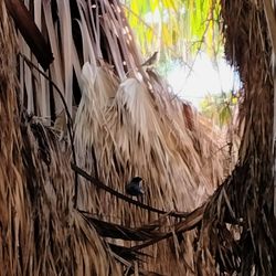
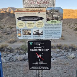
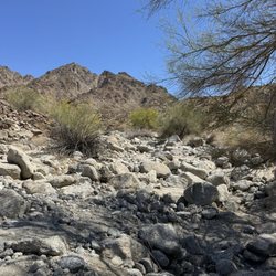
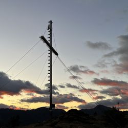
Reviews With Photos

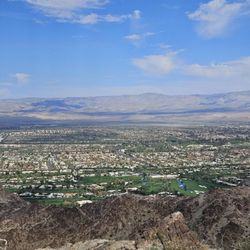
Amazing views of the desert. Well.maintained trails. Some trails have concrete. My lifelong friend & I went to the left on a desert sand trail. We hiked to the cross. I was totally surprised to see a bunch of homes with a lake between them. I was taken by how clean everything was. I have never seen anything so beautiful in the desert. I love the clouds and the mountain formations. I didn't even feel like I was exercising. My friend & I just took in all of the beauty. I am in awe.

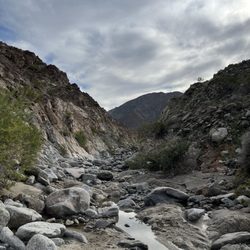
This trail is AWESOME. It is so engaging, beautiful, and ... maybe playful is the right word? See the pictures and videos attached to get a good sense of it. If you go clockwise, the hike starts with ascending *into* the badlands where you're weaving through the landscape by walking up rock stairs, through mountainous crags, and starting to approach the mountaintop. NOTE: When you get to the trailhead and start the hike, take the trail left, directly away from the golf course, where the marker sign is. Soon enough you'll see a lake/pond and housing community in the distance. You will turn to the right 90* to head toward the badlands. However, either we missed the marking sign, or there isn't one. Try to look for a dead straight path that goes under the power lines. If you walk toward the lake/pond/housing community enough that you see the big Cross in the ground, you've gone too far. Once you ascend to the mountaintop via the switchbacks, you'll traverse the top for a mile or so. Beautiful views on a sunny day. The descent is quick but not difficult. We went in Feb and it was perfect temperature, sunny, and windy. Long sleeves and shorts were perfect. There were no spots left in the small parking lot, so we parked on the street just outside the parking lot.

1 year ago
Nice place for a walk and the scenery was great. I will admit I didn't follow all the posts showing the trail, I ended up walking an extra 2 miles. I'm not complaining though. The walk is well marked, slot canyons and all. I'm glad I did it early morning, used 1.5 liters of water. I'd like to walk it again read more


5 months ago
This review is for the East Indio Hills Badlands which was a ~5.2 mile round trip that took ~ 2.5 hours to complete. Parking is on the dirt road. This trailhead seemed popular especially since it's close to the city. For this particular trail, you follow the signs for Indio Hills Badlands. It's straightforward for the most part but also recommend downloading the map from AllTrails in case you need it. Trail was comprised of sand and dirt. Plenty of rock formations throughout the hike and awesome views at higher elevation. This hike sort of reminds me of a mix of Slot Canyon in Anza Borrego and Vasquez Rocks in Agua Dulce. Short video of the hike for those interested! https://youtu.be/1VuvNgk-sJg read more


Amazing views of the desert. Well.maintained trails. Some trails have concrete. My lifelong friend & I went to the left on a desert sand trail. We hiked to the cross. I was totally surprised to see a bunch of homes with a lake between them. I was taken by how clean everything was. I have never seen anything so beautiful in the desert. I love the clouds and the mountain formations. I didn't even feel like I was exercising. My friend & I just took in all of the beauty. I am in awe. read more


This trail is AWESOME. It is so engaging, beautiful, and ... maybe playful is the right word? See the pictures and videos attached to get a good sense of it. If you go clockwise, the hike starts with ascending *into* the badlands where you're weaving through the landscape by walking up rock stairs, through mountainous crags, and starting to approach the mountaintop. NOTE: When you get to the trailhead and start the hike, take the trail left, directly away from the golf course, where the marker sign is. Soon enough you'll see a lake/pond and housing community in the distance. You will turn to the right 90* to head toward the badlands. However, either we missed the marking sign, or there isn't one. Try to look for a dead straight path that goes under the power lines. If you walk toward the lake/pond/housing community enough that you see the big Cross in the ground, you've gone too far. Once you ascend to the mountaintop via the switchbacks, you'll traverse the top for a mile or so. Beautiful views on a sunny day. The descent is quick but not difficult. We went in Feb and it was perfect temperature, sunny, and windy. Long sleeves and shorts were perfect. There were no spots left in the small parking lot, so we parked on the street just outside the parking lot. read more


2 years ago
I was here enjoyed my hike there is always a good amount of people. Nice time of the year to go hiking. read more


2 years ago
3 years ago
More info about Indio Hills Badlands Trailhead
Ask the Community - Indio Hills Badlands Trailhead
You might also consider


Why does Yelp recommend reviews?
1 review that is not currently recommended
The reviews below are not factored into the business's overall star rating.
4 months ago
Indio Hills Badlands Trailhead - hiking - Updated July 2026
Best of Indio
People found Indio Hills Badlands Trailhead by searching for…
Trending Searches in Indio, CA
Boat Tours near Indio Hills Badlands Trailhead
Cliff Jumping near Indio Hills Badlands Trailhead
Cruising Spots near Indio Hills Badlands Trailhead
Day Trips near Indio Hills Badlands Trailhead
Dog Friendly Things To Do near Indio Hills Badlands Trailhead
Jet Ski Rental near Indio Hills Badlands Trailhead
Kayak Rental near Indio Hills Badlands Trailhead
Kids Activities Indoor near Indio Hills Badlands Trailhead
Lakes near Indio Hills Badlands Trailhead
Off Road Trails near Indio Hills Badlands Trailhead
Outdoor Activities near Indio Hills Badlands Trailhead
Peach Picking near Indio Hills Badlands Trailhead
Places To Walk Around near Indio Hills Badlands Trailhead
Public Shower near Indio Hills Badlands Trailhead
Rainy Day Activities near Indio Hills Badlands Trailhead
River Swimming near Indio Hills Badlands Trailhead
Rock Quarry near Indio Hills Badlands Trailhead
Scenic Night View near Indio Hills Badlands Trailhead
Scenic Overlook near Indio Hills Badlands Trailhead
State Parks near Indio Hills Badlands Trailhead
Surf Shop near Indio Hills Badlands Trailhead
Swimming Holes near Indio Hills Badlands Trailhead
Swimming Lakes near Indio Hills Badlands Trailhead
Things To Do On A Rainy Day near Indio Hills Badlands Trailhead
Tubing near Indio Hills Badlands Trailhead
Watch Sunset near Indio Hills Badlands Trailhead
Browse Articles
Browse Nearby
BEST of Indio, California Things to Do near Indio Hills Badlands Trailhead
BEST of Indio, California Restaurants near Indio Hills Badlands Trailhead
BEST of Indio, California Parks near Indio Hills Badlands Trailhead
BEST of Indio, California Coffee near Indio Hills Badlands Trailhead
BEST of Indio, California Lakes near Indio Hills Badlands Trailhead
BEST of Indio, California Breakfast near Indio Hills Badlands Trailhead
BEST of Indio, California Campgrounds near Indio Hills Badlands Trailhead
BEST of Indio, California Taxis near Indio Hills Badlands Trailhead
Browse Brands
Related Searches in Indio, CA
Best Dog Hiking Trails Around Indio, California
Best Fishing Locations and Guides in Indio, California
Best Nature Trails for Hiking in Indio, California
Best Places for Horseback Riding in Indio, California
Best Sightseeing Experiences Available in Indio, California
Check Out Off Road Trails in Indio, California
Discover Dog Friendly Trails to Explore in Indio, California
Discover Easy Hiking Trails Near Indio, California
Discover Kid Friendly Hiking Trails in Indio, California
Discover Popular Bike Trails in Indio, California
Discover Scenic Mountain Bike Trails Near Indio, California
Discover a Hiking Trail in Indio, California
Discover the Best Night Hike Trails in Indio, California
Dog-Friendly Hikes With Dogs in Indio, California
Enjoy Camping Adventures Around Indio, California
Enjoy Exciting Mountain Biking Adventures in Indio, California
Enjoy Kayaking Adventures in Indio, California
Enjoy Off Leash Dog Hikes in Indio, California
Enjoy Scenic Places to Walk in Indio, California
Enjoy Tent Camping Spots Around Indio, California
Enjoy a Beautiful Waterfall Hike in Indio, California
Enjoy the Best Walking Path in Indio, California
Enjoy the Best Walking Trails in Indio, California
Explore Beautiful Parks and Green Spaces in Indio, California
Explore Easy Hikes Perfect for All in Indio, California
Explore Fun Activities to Do in Indio, California
Explore Popular Campgrounds Near Indio, California
Explore Top Dog Parks in Indio, California Near You
Family Friendly Hiking With Kids in Indio, California
Find Beautiful Views in Indio, California
Find Top Dog Friendly Parks to Visit in Indio, California
Find Top-Rated Waterfalls in Indio, California Now
Find the Best Parks for Picnics in Indio, California
Find the Best Playgrounds to Visit in Indio, California
Hiking Trails With Waterfalls in Indio, California
Off Leash Dog Hiking Trails in Indio, California
Plan a Scenic Drive Route Near Indio, California
Popular Outdoor Activities to Try in Indio, California
Popular Picnic Spots to Visit in Indio, California
Safe River Swimming Areas in Indio, California
Safe and Fun Parks for Kids in Indio, California
Top Hiking Trails to Explore in Indio, California
Top Playgrounds for Kids to Enjoy in Indio, California
Top Running Trails to Explore in Indio, California
Top Swimming Lakes to Enjoy in Indio, California
Top Swimming Spots and Pools in Indio, California
People who viewed Indio Hills Badlands Trailhead also viewed
La Quinta Cove Hike
43 reviews
Bump and Grind Trail, Mike Schuler Trail Head
97 reviews
Coachella Valley Preserve
122 reviews
Martinez Mountain
2 reviews
Oswit Canyon Loop Trail
1 review
Tahquitz Canyon
250 reviews
Cactus to Clouds Hike, Mt. San Jacinto Peak
75 reviews
Randall Henderson Loop
11 reviews
Butler Abrams Trail
1 review
Willis Palms Oasis
1 review